
Where Flight Simulation Enthusiasts Gather from Around the World!
AVSIM Library - Search Results

| Category: Flight Simulator X - Aircraft Repaints, Textures and Modifications | |
| FSX FA-18 2024 Aerodynamic Performance Upgrade |

|
Images related to this file:
File Description:

This is a performance mod/upgrade for the FSX Acceleration/Steam FA-18 Hornet. This will also work with both the "Sludge Hornet" and with the "Combat" add-ons. The inspiration for this "Upgrade" came from the YouTube vids of the AWESOME Swiss and Finnish F-18C Hornet Demos at RIAT RAF Fairford! After seeing those, I went to work modifying the "aircraft.cfg" and "FA-18.air" files and got the "old" FSX Hornet to fly like a NEW jet! Think of it like fixing up an old sports car, putting in a new engine, suspension, and when you're done it drives better than when it was new! I've made the upgrade instructions easy and it should only take just a couple minutes to complete. THEN your FSX FA-18 Hornet will look and fly like the ones in those videos!! And it won't just be great at airshow flying, it will also fly smooth and stable around the carrier, and will be LOTS of fun "free flying" through the mountains at 500ft and 500kts! I've also included new/upgraded afterburner textures, and a Shockwave exterior light upgrade. And as a BONUS, I've included BOTH the Swiss J-5011 and Finland HN-411 RIAT Airshow repaint textures.
| Filename: | FSX_FA18_2024_Aerodynamic_Performance_Upgrade.zip |
| License: | Freeware |
| Added: | 16th January 2024, 14:26:37 |
| Downloads: | 127 |
| Author: | Daniel Gregory |
| Size: | 7.29 MB |
| Category: Flight Simulator 2002 - Scenery | |
| Mikonos and Ikaria Island Airports |
|
File Description:
FS2002 Mikonos LGMK and Ikaria LGIK of the Aegean sea in Greece. Two typical summer holiday destinations in Hellas. The scenery represents Mikonos and Ikaria Island Regional Airports. Several objects like trucks, houses, stones, fences, and proper photorealistic textures have been used to make this airport as real as it gets and help the scale perception of the pilot. Special care has been taken for night lighting. Ikaria, a mountainous, thickly forested island, perpetuates the myth of Ikarus and his fall into the sea near its south shores after his bold attempt to reach the sun with his waxen wings. Mikonos in the center of Aegean sea, has been one of the best keeper of traditional Aegean architecture and is well known for it's popular golden sandy beaches and ecstatic nightlife. It is called "The island of winds" and indeed it is. Most frequent North winds have no physical barrier, all the way from Northern Greece, to weaken them and the constant seabed from there helps the increase of wind's speed by the time it reaches Mikonos. Beware of steep rising terrain and the wind gusts and downdrafts on short finals. Use this scenery preferably tohether with the free Greek Mesh Scenery by Babis Perivolas.
| Filename: | Mikonos_and_Ikaria_Island_Airports.zip |
| License: | Freeware |
| Added: | 12th November 2002, 19:49:45 |
| Downloads: | 6,075 |
| Author: | Vangelis Generalis |
| Size: | 2.93 MB |
| Category: Orbiter - Spaceships | |
| Pioneer 4 Add-on for Orbiter |
|
File Description:
Pioneer 3 and 4 were early satellites designed to be lofted toward Earth's Moon. They were equipped with Geiger counters to measure radiation in space. Pioneer 3 was launched from Cape Canaveral, Florida, on December 6, 1958.
Because of a slight error in the satellite's velocity and angle after burnout of the Juno II rocket, it did not reach the Moon; instead it achieved a peak altitude of 102,320 kilometers (63,580 miles). The satellite did, however, discover a second radiation belt around Earth during its flight. Pioneer 3 reentered Earth's atmosphere over equatorial Africa a day after launch.
Pioneer 4 was launched March 3, 1959, and successfully passed within 60,000 kilometers (37,300 miles) of the Moon the following day. The satellite was tracked for 82 hours to a distance of 655,000 kilometers (407,000 miles) from Earth, a record at that time. Pioneer 4 is now orbiting the Sun, the first U.S. spacecraft placed in solar orbit.
The Orbiter version will do a little better than get you within 60,000 kilometers like the real one achieved. The flight profile included usually will get you to within 8,000 kilometers, and sometimes, depending on the mood of your copy of Orbiter, may even impact the moon! However since installations may vary, your distance to the moon on arrival, or even impacting the moon, is not guaranteed. Just like the real thing!
| Filename: | Pioneer_4_Addon_for_Orbiter.zip |
| License: | Freeware |
| Added: | 19th October 2004, 19:59:22 |
| Downloads: | 682 |
| Author: | Jim Williams |
| Size: | 530.42 KB |
| Category: Flight Simulator X - Scenery | |
| RNAS Anthorn (HMS Nuthatch) - Cumbria, UK |
|
File Description:
This scenery is a representation of RNAS Anthorn (HMS Nuthatch) prior to runway and taxiway upgrades completed in 1948. It is not 100% accurate and no claim is being made that it is.
The scenery was made using ADE and is intended for use in FSX along with Horizon GenX VFR scenery but should work ok in Basic FSX.
Some History: Anthorn air field (also known as RAF Anthorn, RNAS Anthorn and HMS Nuthatch) was an airfield approximately 430 KM north-northwest of London
The airfield was built in february 1918 as a Fleet Air Arm (FAA) airfield. It was abandoned after World War I ended, however. The RAF reinstated the airfield at the beginning of World War II as an emergency landing ground for nearby RAF Silloth.
The site was taken over by the Royal Navy in December 1942, and renamed the site RNAS Anthorn. It was commissioned in September 1944 as 'HMS Nuthatch'.
The airfield served as No. ARDU (Aircraft Receipt and Dispatch Unit), a unit that accepts aircraft from their manufacturers and prepares them for operational use.
The last official flight took off from the airfield in November 1957. It was then put on Care and Maintenance, before it closed down in March 1958.
In 1961 the site was chosen to become a NATO VLF transmitting site for communicating with submarines. Construction of the site, by Continental Electronics of Dallas, U.S.A., began in 1962.
The station was accepted on behalf of the MoD in November 1964.
| Filename: | RNAS_Anthorn_HMS_Nuthatch__Cumbria_UK.zip |
| License: | Freeware |
| Added: | 1st March 2015, 23:11:58 |
| Downloads: | 435 |
| Author: | Mark Byers |
| Size: | 21.34 MB |
| Category: Miscellaneous Files - General Utilities | |
| Flight plan management table |
|
File Description:
THe Flight management table is an excel file which will help you to monitor weights and time of your flight plan.
You can insert the following info:
-Departure
-Arrival
-Callsign
-Flight number
-Route distance
-Number of pax
-Cost index
-Cruise altitude
-Block fuel, taxi fuel, trip fuel, extra fuel, reserve fuel
You can also manage time by inserting simulation date, start time, cockpit preparation time and many more.
The file also gives you an advice if you make a mistake and will calculate the fuel you have to burn if you have to perform an emergency landing but you are above the max landing weight.
The excel file will then calculate zero fuel weight, gross weight, takeoff and landing weights based on the "active aircraft management table".
It will also calculate off and on block time as well as takeoff and landing time.
You can use this file with any aircraft by adding tamplates to it or using one that is already in the file. At present the tamplates available are:
X plane
-Flight Factor A320 Ultimate
-Zibo mod B738
-IXEG B733
-Aerobask Eclipse 550NG
Prepar3d/Flight sim X
-PMDG B738 NGX
-Majestic Dash 8 Q400
Creating a new tamplate is easy. All you need to do is having weights info about the aircraft you wish to add in hand.
The file is under development which means that I am going to add new feature to it.
A good breefing is the first step for a good flight.
| Filename: | Flight_plan_management_table.zip |
| License: | Freeware |
| Added: | 9th August 2018, 14:21:41 |
| Downloads: | 336 |
| Author: | Luca Tessieri |
| Size: | 17.92 KB |
| Category: Flight Simulator X - Aircraft Repaints, Textures and Modifications | |
| North American P-51D Mustang "Hell-er Bust" |
|
Images related to this file:
File Description:
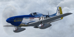
A repaint only for the payware Warbirdsim product 'Mustang Tales'. This repaint depicts the restored P-51D-20-NA 44-72438, "Hell-er Bust", registered N7551T. This specific aircraft is known to have been delivered to the 8th Air Force in England in late January 1945, however no available records indicate any combat time or what, if any, Fighter Group the aircraft was assigned. Following the end of WWII the aircraft served with the Swedish AF as Fv26131, and then with the Dominican AF as FAD 1920. After being imported back into the U.S. in the 1980's, the aircraft was purchased by Selby Burch and given a ground-up restoration. Finished in 118th TRS markings, the aircraft won the Grand Champion WWII Warbird award at Sun 'N Fun 1997. The aircraft was later purchased by Bob Jepson/Lady Alice Corporation and first repainted as 'Lady Alice' and then as 'Hell-er Bust'. In 2006 the aircraft was obtained by the Historic Aircraft Foundation and based at Paine Field, near Seattle, WA. Since 2009, the aircraft has been owned by Mark Peterson/Mustang High Flight LLC, based at Boise, Idaho, and remains finished as 'Hell-er Bust'. The markings depict an original wartime mount of Lt. Col. Edwin L. 'Ed' Heller, a P-51D-10-NA (44-14696) of the 486th FS, 352nd FG. This repaint features new bump maps, wheel well, gun bay, and cockpit textures.
| Filename: | North_American_P51D_Mustang_Heller_Bust.zip |
| License: | Freeware |
| Added: | 14th April 2013, 21:42:25 |
| Downloads: | 215 |
| Author: | John Terrell |
| Size: | 25.84 MB |
| Category: Civil Flight Simulators - Micro Flight | |
| Micro Flight 5 |
|
File Description:
Micro Flight is a state of the art flight simulator specializing in simulating ultralight flying vehicles and micro meteorological conditions.
Unlike other flight simulators, Micro Flight simulates the intricate flow of air over the ground and the effects of thermals created by the sun, making it ideal for simulating gliders of all types.
Micro Flight also simulates types of vehicles not simulated by other general aviation programs, such as: Hanggliders, Paragliders, Gyroplanes, Helicopters, Trikes, Balloons and more.
Flight instrumentation and navigational aids were made to resemble real ones, this includes the hand held GPS, standard flight instruments, head up display and more.
The whole enviroment which the user interacts with is three dimentional, even operating the instruments in the cockpit is made by manipulating them with the mouse and not just by pressing keys.
The terrain model used is detailed and optimized, giving the terrain a photorealistic look while still maintaing a high frame rate during run.
The program supports a wide variety of scenery formats, and can import aerial photography and USGS digital elevation data directly.
The program includes flight recording and anaylis, giving the user the ability to study the flight in detail and export it's path in digital form for any purpose.
The program has netplay mode which enables users to fly and communicate with each other.
All this and more make the program a unique and valueable tool for flight simulation.
Copyright Ilan Papini 1999 - 2004 ©
| Filename: | Micro_Flight_5.zip |
| License: | Commercial demo |
| Added: | 16th December 2004, 04:03:44 |
| Downloads: | 543 |
| Author: | Ilan Papini |
| Size: | 6.46 MB |
| Category: Flight Simulator X - Aircraft Repaints, Textures and Modifications | |
| B-24 USAAF 376th BG "Lady be Good" |
|
File Description:
Following an April 4, 1943 bombing raid on Naples, Italy, conducted by the 376th Bomb Group, the Lady Be Good of the 514th Bomb Squadron failed to return to base. After attempts to locate the plane, its nine crewmen were classified as MIA, and presumed dead, believed to have perished after crashing in the Mediterranean.
Almost 16 years later on Nov. 9, 1958, several British geologists were flying over the desolate, sun-baked Libyan Desert. At approximately 400 miles south of Soluch, they spotted an aircraft on the sand. A ground party that reached the site in March 1959 discovered the plane to be a B-24D. The "Lady Be Good" had been found.
Evidence at the site indicated that the crew had become lost in the dark on return from Naples and had flown over their base and southward into the desert. As their fuel supply became depleted, the nine men aboard had bailed out but had disappeared while attempting to walk northward to civilization.
Intensive searches were made for clues as to the fate of the crew, and in 1960 the remains of eight were found, one near the plane and the other seven far to the north. Five had trekked 78 miles across the tortuous sand before perishing and one had gone an amazing 109 miles. In addition, they had lived eight days rather than only two expected of men in this area with little or no water. The body of the ninth man was never found.
Repaint for the Alphasim B-24 by Jan Kees Blom.
| Filename: | B24_USAAF_376th_BG_Lady_be_Good.zip |
| License: | Freeware |
| Added: | 11th October 2008, 13:11:09 |
| Downloads: | 386 |
| Author: | Jan Kees Blom |
| Size: | 7.61 MB |
| Category: Flight Simulator 2004 - Scenery | |
| Replacement Dynamic Water Textures v11 |
|
File Description:
Replacement dynamic water texture-sets for FS2004 (VERSION 11). These newer version 11 moon light textures are a completely new type than my earlier versions. The results are much improved and there is also a "new moon" texture in this version which is a more realistic and darker blue/black which contrasts nicely with my moon light textures. This compares quite drastically to the default over lit pinkish brown tones the default FS9 uses for a new moon. Now when you fly by moonlight you can actually see the moon kissed water and even see some wave action. It actually feels like you are there! There are 2 moon light textures in this download. The default reflections and water colors leave a lot to be desired in FS2004. As an example; The default milky "bright green" overcast texture is highly unrealistic in overcast conditions. The replacement textures will change this dramatically to a much more convincing and realistic "blue/grey", cast, with improved lighting and reflections in respect to the sun. These replacement textures will generally give a much more realistic tone and color to the water effects in FS2004. The change is quite dramatic and transforms the flight sim experience to a much greater level of realism. It is important to stress the default FS9 textures are fully compatible with these new textures and they can be used in any combinations and can be mixed and matched with the new textures. For example it may be that some users want to keep some of the water environment textures as they are by default but change only one or two textures. The choice is yours. As a further added bonus a voice control file has been included for "Shoot" which will control FS2004 by voice. It is brilliant and it's free.
| Filename: | Replacement_Dynamic_Water_Textures_v11.zip |
| License: | Freeware |
| Added: | 11th January 2004, 20:38:03 |
| Downloads: | 3,057 |
| Author: | Peter Wilding |
| Size: | 3.49 MB |
| Category: Miscellaneous Files - Miscellaneous Files | |
| CPS-NG RC 5 |
|
File Description:
CPS-NG (Concorde Performance System New Generation) is the successor to CPS-X, the essential flight preparation utility created in 2011
and discontinued in 2018.
Since the end of its development, still present on AVSIM despite a large number of unavailable functions, it has been downloaded more
than 3000 times.
This new CPS opus will satisfy the most demanding Concorde simulation enthusiasts.
CPS-NG now makes it possible to plan Concorde flights with the following simulators:
FsLabs Concorde X for FSX, and P3D up to version 3.
Colimata Concorde FXP for X-Plane and Gaston Reif's beautiful mod, Heritage Concorde Avionics Package.
With these simulators, CPS-NG can export waypoints to INS, payload and fuel to aircraft.
Like its illustrious predecessors, CPS-NG uses authentic Air France data and charts.
It offers a map of the flight including the navigation points, the points to protect from the supersonic bang, on departure and on
arrival
The flight preparation stages are done in a user-friendly way.
the subsonic levels are configurable, the anti-noise procedures are calculated as in reality. The loading of the plane is modifiable by
the user in order to obtain the ideal centering.
The fuel is calculated as in reality and its distribution in the 11 tanks of Concorde complies with the filling law of Air France and
British Airways.
CPS-NG like its previous version also offers the user a flight report in the form of a PDF document which contains all the elements
necessary for the preparation of the aircraft.
it also offers Concorde-specific settings such as initial climb angle, time until anti noise procedure, throttle levers angle during
anti noise procedure, fuel flow, maximum pressure in P7,
trim adjustment and everything a pilot and flight engineer could want for a perfect flight.
CPS-NG also offers in the flight report, Take-off and landing forms in accordance with the real documents and the user has the choice
between the Air France form and the British Airways one.
Finally, CPS-NG allows the use of real-time weather from NOAA, personalized weather or the one generated by Active Sky 2016,
Active Sky for P3D and Active Sky for X-Plane 11 or 12.
In summary, here you have the ultimate tool for Concorde simulation.
You dreamed it, we did it!
Break the sound barrier.
| Filename: | CPSNG_RC_5.zip |
| License: | Freeware |
| Added: | 10th August 2023, 15:48:00 |
| Downloads: | 72 |
| Author: | Pierre Chassang |
| Size: | 19.49 MB |
© 2001-2026 AVSIM Online
All Rights Reserved
Privacy Policy |