
Where Flight Simulation Enthusiasts Gather from Around the World!
AVSIM Library - Search Results

| Category: Fly! II - Aircraft | |
| De Havilland Canada DHC2 Beaver (on floats with retracts) |

|
File Description:
IBM PC VERSION ONLY. This file contains DLL's that are not Mac. compatible.
A total of over 1500 aircraft were built. With double slotted full span flaps (drooping ailerons) and 1000lbs payload, its STOL capability, along with having a float version with retracts, made it an ideal "Bushplane" with unparalelled performance from any contempory aircraft. Many Beavers are still in use today.
The model was built using Truespace 4.3 and Chris Wallace's 3ds to S3d converter. Photorealistic interior views are used with auto switching day-time/night-time main panel.
The model requires that you have the Tri default aircraft installed.
A few non-standard features have been included to improve the ease of operation.
1. nose wheel steering (the original uses differential braking and castoring nose gears)
2. an electric pump for hydraulics (optional on the original )
3. a simple GPS that can be slaved to the auto pilot. (unheard of during the production life of the original but very likely to be found on any survivng present day aircraft.
4. a transponder has been added to enable IFR flights
| Filename: | De_Havilland_Canada_DHC2_Beaver__on_floats_with_re.zip |
| License: | Freeware, limited distribution |
| Added: | 31st August 2008, 07:45:53 |
| Downloads: | 314 |
| Author: | Paul Simpson, Laurent Claudet, Randall Rocke, Roger Mazengarb |
| Size: | 4.85 MB |
| Category: Flight Simulator 2004 - Scenery | |
| WLP-HQ |
|
File Description:
WLP HQ is a basic simple scenery. It's a fictous bush-airport and camp in northern Tanzania, just west of the famous Lake Natron.
WLP stands for "Wild Life Protection". WLP is a fictous project and is refering to J.T. Chance's latest adventure novel. Max Stein, a bushpilot and adventurer, is hunting down smuggling and illegal hunting gangs. This project stands for a complete new approach by making the reader a part of the story ... kind like interactiv action if you will say so. The book invites you to fly it's hero adventures in your flightsim, therefore you got maps, flightplans and so on with the book. (No need for a specific flightsim version.)
WLP HQ is the main base of these operations. You'll take over from there and you follow the storyline on your own yoke. There is no need to download any further files to do so. This scenery is freeware of course, the adventure may be purchased (inexpensive paper-back or even cheaper PDF download) on lulu.com
| Filename: | WLPHQ.zip |
| License: | Freeware |
| Added: | 19th January 2007, 01:32:36 |
| Downloads: | 457 |
| Author: | J.T. Chance |
| Size: | 3.37 MB |
| Category: Flight Simulator 2004 - Gauges | |
| TerraVue: Moving Map, Ground Proximity, Information pages |
|
File Description:
FS2004 Gauge: TerraVue. This gauge contains a moving map display with a terrain elevation legend color-keyed to the FS9 map. The legend allows the elevation of terrain lying ahead of the aircraft to be taken into account. TerraVue can display the FS map in seven ranges from 4 NM to 160 NM. The Map mode also employs animation to show the proximity between the aircraft and ground in a graphical and digital display with indicators showing whether the distance is increasing or decreasing. The gauge can be switched to the Information mode which will display up to four individual pages of data that is created by you. These scrollable pages may contain checklists, airport diagrams, approach plates, strip charts, etc. Fully functional, free software to help quickly construct these pages is included along with an illustrated tutorial that demonstrates the simple copy/paste process that tailors these pages to include whatever data you wish. For panel or separate window installation with TerraVue Icon gauge. By Glenn Copeland
| Filename: | TerraVue_Moving_Map_Ground_Proximity_Information_p.zip |
| License: | Freeware |
| Added: | 24th June 2006, 15:13:12 |
| Downloads: | 5,078 |
| Author: | Glenn Copeland |
| Size: | 1.92 MB |
| Category: Flight Simulator 2004 - Original Aircraft | |
| A.V.I.A. L.3 (Part 1) |
|
Images related to this file:
File Description:

The L.3 was a partially failed attempt to create a very simple and cheap monoplane trainer, better suited to the entire basic training syllabus of Regia Aronautica pilots from 1940 onwards. This open cockpit version was also adopted for 'lead in' training, by the Croatian Air Force, and eventually the Luftwaffe, and by the A.N.R. for assault glider pilot training. Some also served as 'unit hacks' during WW2. Full details are in the supplied contextual history.
This release (Part 1) provides two open cockpit MDLs, with different landing gear, many relevant liveries, a combined contextual history of both the open and closed cabin versions, and an illustrated Student Training Manual to allow realistic simulation of the wartime Axis 'lead in' training syllabus. The Part 2 of this release will later feature the enclosed cabin version.
VC only. It also works subject to some limitations within in FSX. GMax Models and Skins by Manuele Villa, Flight dynamics by FSAviator. By Manuele Villa/MVG3D, January 2015.
| Filename: | AVIA_L3_Part_1.zip |
| License: | Freeware |
| Added: | 29th January 2015, 21:21:19 |
| Downloads: | 665 |
| Author: | Manuele Villa |
| Size: | 40.4 MB |
| Category: Flight Simulator 2004 - Scenery | |
| Airports of Iran V1.1 |
|
Images related to this file:
File Description:

This package creates a simple basic scenery of airports of Iran and it is purposed to have the maximum technical match with the reality, not necessarily the exact scenery textures. The most of Iranian airports in FS2004 have a very poor, out of date and incomplete design, some are only a runway and some do not even exist! No model design has been performed using for this package and all the scenery objects are the available free-ware objects on the online libraries. The main purpose of PERSIAN-SIM | Airports of Iran is to create a maximum match of the airports technical elements with the reality, e.g. the size and location of the buildings, dimensions and distances of runways, taxiways, aprons, stands, gates etc. and also airports lighting systems and NAVAIDs. The technical information including Comm. Frequencies, navigation systems, NAVAIDs, TWYs and RWYs characteristics and dimensions are designed and updated using Iran AIP and other valid up-to-date aviation resources. Special thanks to John Stinstrom and Sidney Schwartz for their permission and helps.
| Filename: | Airports_of_Iran_V11.zip |
| License: | Freeware, limited distribution |
| Added: | 15th January 2013, 17:27:17 |
| Downloads: | 2,614 |
| Author: | Behnam Zamani / PERSIAN-SIM |
| Size: | 25.88 MB |
| Category: Flight Simulator X - Scenery | |
| South China Sea Bases |
|
File Description:
This file contains five man-made bases with helipads which have been created in recent times by China, AND one man-made island airport with a large runway in the same area. The South China Sea is an area with disputed claims, with no natural land the UN has made several rulings. Many nations conduct what is called 'Right of Navigation' covered by the UNCLOS Part VII, which allows freedom of overflight and navigation. Also included is the Fuluo North East AB on Hainan Island. Note these are simple basic sceneries to allow flying around the area in FSX. There was nothing in FSX, and many dont have ICAO IDs assigned. These are not payware quality, however they were created with ADE. Thanks goes to them.
Included are
++ AG882 - Fuluo NE AB - large Air base
++ ZCUA - Huayang Jiao (Cuarteron Reef) Helipad
++ ZGAV - Nanxun Jiao (Gaven Reef) Helipad
++ ZHUG - Dongmen Jiao (Hughes Reef) Helipad
++ ZJOH - Chigua Jiao (Johnson South Reef) Helipad
++ ZMIS - Meiji Jiao (Mischief Reef) Large Airport
++ ZSC2 - Sin Cowe Island - Helipad
| Filename: | South_China_Sea_Bases.zip |
| License: | Freeware |
| Added: | 5th August 2017, 22:54:53 |
| Downloads: | 464 |
| Author: | Sean Harrison |
| Size: | 280.77 KB |
| Category: Flight Simulator X - Utilities | |
| FSX/P3D Quick ILS Utility Ver 3.1.5 **UPDATE ** |
|
Images related to this file:
File Description:
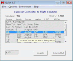
This utility was written to simplify the process of finding the ILS frequency when ATC assigns an ILS approach. Operation is simple. Enter the ICAO, click the Search button and a list of all runways, runway lengths and runway ILS frequencies for that ICAO are displayed. Here's the quick part... Just double click on a runway and the ILS frequency will instantly be set in the Nav1 radio. You can also start Flight Simulator, load a flightplan and then start Quick ILS. It will automatically read the flightplan and then display the destination airport's runway data. Again, just double click on the assigned runway to set the Nav1 radio for the ILS approach. ILS data aside, General Aviation fans may want to use Quick ILS to get information about possible destination airports. Enter an ICAO and you can quickly view the runways available, their length, the surface (ie grass, gravel, paved...) and the runway headings. Version 3.1.5 adds the ILS ID to the display. Freeware by Dave Westbury.
| Filename: | FSXP3D_Quick_ILS_Utility_Ver_315_UPDATE_.zip |
| License: | Freeware |
| Added: | 12th August 2014, 10:25:51 |
| Downloads: | 3,578 |
| Author: | Dave Westbury |
| Size: | 457.35 KB |
| Category: Flight Simulator X - Aircraft Repaints, Textures and Modifications | |
| North American P-51D Mustang "Hell-er Bust" |
|
Images related to this file:
File Description:
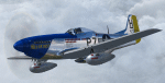
A repaint only for the payware Warbirdsim product 'Mustang Tales'. This repaint depicts the restored P-51D-20-NA 44-72438, "Hell-er Bust", registered N7551T. This specific aircraft is known to have been delivered to the 8th Air Force in England in late January 1945, however no available records indicate any combat time or what, if any, Fighter Group the aircraft was assigned. Following the end of WWII the aircraft served with the Swedish AF as Fv26131, and then with the Dominican AF as FAD 1920. After being imported back into the U.S. in the 1980's, the aircraft was purchased by Selby Burch and given a ground-up restoration. Finished in 118th TRS markings, the aircraft won the Grand Champion WWII Warbird award at Sun 'N Fun 1997. The aircraft was later purchased by Bob Jepson/Lady Alice Corporation and first repainted as 'Lady Alice' and then as 'Hell-er Bust'. In 2006 the aircraft was obtained by the Historic Aircraft Foundation and based at Paine Field, near Seattle, WA. Since 2009, the aircraft has been owned by Mark Peterson/Mustang High Flight LLC, based at Boise, Idaho, and remains finished as 'Hell-er Bust'. The markings depict an original wartime mount of Lt. Col. Edwin L. 'Ed' Heller, a P-51D-10-NA (44-14696) of the 486th FS, 352nd FG. This repaint features new bump maps, wheel well, gun bay, and cockpit textures.
| Filename: | North_American_P51D_Mustang_Heller_Bust.zip |
| License: | Freeware |
| Added: | 14th April 2013, 21:42:25 |
| Downloads: | 215 |
| Author: | John Terrell |
| Size: | 25.84 MB |
| Category: Civil Flight Simulators - Micro Flight | |
| Micro Flight 5 |
|
File Description:
Micro Flight is a state of the art flight simulator specializing in simulating ultralight flying vehicles and micro meteorological conditions.
Unlike other flight simulators, Micro Flight simulates the intricate flow of air over the ground and the effects of thermals created by the sun, making it ideal for simulating gliders of all types.
Micro Flight also simulates types of vehicles not simulated by other general aviation programs, such as: Hanggliders, Paragliders, Gyroplanes, Helicopters, Trikes, Balloons and more.
Flight instrumentation and navigational aids were made to resemble real ones, this includes the hand held GPS, standard flight instruments, head up display and more.
The whole enviroment which the user interacts with is three dimentional, even operating the instruments in the cockpit is made by manipulating them with the mouse and not just by pressing keys.
The terrain model used is detailed and optimized, giving the terrain a photorealistic look while still maintaing a high frame rate during run.
The program supports a wide variety of scenery formats, and can import aerial photography and USGS digital elevation data directly.
The program includes flight recording and anaylis, giving the user the ability to study the flight in detail and export it's path in digital form for any purpose.
The program has netplay mode which enables users to fly and communicate with each other.
All this and more make the program a unique and valueable tool for flight simulation.
Copyright Ilan Papini 1999 - 2004 ©
| Filename: | Micro_Flight_5.zip |
| License: | Commercial demo |
| Added: | 16th December 2004, 04:03:44 |
| Downloads: | 543 |
| Author: | Ilan Papini |
| Size: | 6.46 MB |
| Category: Miscellaneous Files - General Utilities | |
| Flight plan management table |
|
File Description:
THe Flight management table is an excel file which will help you to monitor weights and time of your flight plan.
You can insert the following info:
-Departure
-Arrival
-Callsign
-Flight number
-Route distance
-Number of pax
-Cost index
-Cruise altitude
-Block fuel, taxi fuel, trip fuel, extra fuel, reserve fuel
You can also manage time by inserting simulation date, start time, cockpit preparation time and many more.
The file also gives you an advice if you make a mistake and will calculate the fuel you have to burn if you have to perform an emergency landing but you are above the max landing weight.
The excel file will then calculate zero fuel weight, gross weight, takeoff and landing weights based on the "active aircraft management table".
It will also calculate off and on block time as well as takeoff and landing time.
You can use this file with any aircraft by adding tamplates to it or using one that is already in the file. At present the tamplates available are:
X plane
-Flight Factor A320 Ultimate
-Zibo mod B738
-IXEG B733
-Aerobask Eclipse 550NG
Prepar3d/Flight sim X
-PMDG B738 NGX
-Majestic Dash 8 Q400
Creating a new tamplate is easy. All you need to do is having weights info about the aircraft you wish to add in hand.
The file is under development which means that I am going to add new feature to it.
A good breefing is the first step for a good flight.
| Filename: | Flight_plan_management_table.zip |
| License: | Freeware |
| Added: | 9th August 2018, 14:21:41 |
| Downloads: | 336 |
| Author: | Luca Tessieri |
| Size: | 17.92 KB |


© 2001-2026 AVSIM Online
All Rights Reserved
Privacy Policy |