
Where Flight Simulation Enthusiasts Gather from Around the World!
AVSIM Library - Search Results

| Category: Flight Simulator 2002 - AI Flight Plans | |
| Ecuadorian Real AI Traffic |

|
File Description:
This software contains real ecuadorian callsigns,
AI aircrafts and routes according to real airline
schedules of the most popular Ecuadorian Airlines.
This is the Version 1.0 and includes TAME and
Aerogal. This will bring "life" to Quito Scenery
as well as the entire Ecuador, including the
Galapagos Islands.
VoicePack 2.x, and traffic tools required.
| Filename: | Ecuadorian_Real_AI_Traffic.zip |
| License: | Freeware |
| Added: | 23rd April 2003, 12:29:21 |
| Downloads: | 1,166 |
| Author: | Pablo Garzon, Santiago Larreategui and Cristian Caicedo, ECUASIM |
| Size: | 3.64 MB |
| Category: Flight Simulator X - Aircraft Repaints, Textures and Modifications | |
| Cessna C172R (G-NWFC) |
|
Images related to this file:
File Description:
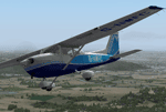
G-NWFC is a C172P operated by the North Weald Flying Group based at......North Weald! The North Weald Flying Group is currently a four Cessna and one Piper aircraft membership flying group based at the historical North Weald Airfield (EGSX).
This paint is freeware, for the payware ($US50) A2A C172R available from...https://www.a2asimulations.com/
| Filename: | Cessna_C172R_GNWFC.zip |
| License: | Freeware |
| Added: | 27th September 2013, 20:40:43 |
| Downloads: | 284 |
| Author: | Ron Attwood |
| Size: | 19.59 MB |
| Category: Flight Simulator 2004 - AI Aircraft | |
| Lao Central Air, Boeing 737-400 (RDPL-34183) |
|
Images related to this file:
File Description:

High quality Repaint of Lao Central Air Boeing 737-400 RDPL-34183 To be used with the Aardvark 737-400 Base Files package available separately.
| Filename: | Lao_Central_Air_Boeing_737400_RDPL34183.zip |
| License: | Freeware |
| Added: | 4th January 2012, 20:48:47 |
| Downloads: | 421 |
| Author: | Doug Roth, GWAI team, Aardvark |
| Size: | 764.37 KB |
| Category: Flight Simulator 2004 - Aircraft Repaints, Textures and Modifications | |
| BR Central, Cessna Grand Caravan C208 (PT-MEI) |
|
Images related to this file:
File Description:
Repaint for the Feelthere Cessna Grand Caravan. Texture Only! Owned and operated by BR Central. A licensed copy of the Feelthere Grand Caravan is required.
| Filename: | BR_Central_Cessna_Grand_Caravan_C208_PTMEI.zip |
| License: | Freeware |
| Added: | 1st February 2010, 11:06:52 |
| Downloads: | 465 |
| Author: | Diogo Luiz Ceccon |
| Size: | 3.45 MB |
| Category: Flight Simulator 2004 - Scenery | |
| Northern Los Angeles Scenery |
|
File Description:
This scenery contains ground scenery for the area of central and northern Los Angeles, SMO, BUR and VNY in standard FS-resolution of 4.7m/pixel.
| Filename: | Northern_Los_Angeles_Scenery.zip |
| License: | Shareware, honor system |
| Added: | 17th August 2006, 03:52:59 |
| Downloads: | 17,065 |
| Author: | Gottfried Razek |
| Size: | 39.6 MB |
| Category: Flight Simulator 2004 - Aircraft Repaints, Textures and Modifications | |
| Lao Central Airlines Boeing 737-400 |
|
Images related to this file:
File Description:

This is an Boeing B737-4K5 of Lao Central Airlines. Registration: RDPL-34183, Repaint by: Mathieu Vos (APSS), Model by: Vistaliners. Also compatible with FSX.
| Filename: | Lao_Central_Airlines_Boeing_737400.zip |
| License: | Freeware |
| Added: | 2nd February 2016, 23:26:59 |
| Downloads: | 203 |
| Author: | Mathieu Vos (APSS) |
| Size: | 4.06 MB |
| Category: Flight Simulator X - Scenery | |
| RAF Topcliffe - Yorkshire, England |
|
File Description:
RAF Topcliffe (ICAO: EGXZ) is a Royal Air Force station in North Yorkshire, England. It is a satellite station serving in the role of a Relief Landing Ground for Tucano aircraft of the Central Flying School (CFS) based nearby at RAF Linton-on-Ouse (one of two, the other being Dishforth Airfield). As such, no RAF personnel are based permanently at the airfield and airfield services are provided by personnel assigned to RAF Linton-on-Ouse.
Topcliffe is also used by the Air Training Corps as a motor glider airfield for Gliding induction courses and Gliding scholarships.
| Filename: | RAF_Topcliffe__Yorkshire_England.zip |
| License: | Freeware |
| Added: | 1st January 2016, 17:50:08 |
| Downloads: | 404 |
| Author: | Terry Boissel |
| Size: | 1.34 MB |
| Category: Flight Simulator 2004 - Scenery | |
| Joplin Regional Airport |
|
Images related to this file:
File Description:
FS9 Scenery - Joplin Regional Airport (IATA: JLN, ICAO: KJLN) is a public airport located four miles (6 km) north of the central business district (CBD) of Joplin, a city in Jasper County, Missouri, USA. The airport covers 970 acres (393 ha) and has three runways. It offers commercial airline service subsidized by the Essential Air Service program. Joplin Regional Airport is owned by the City Of Joplin. The longest runway is a paved runway extending 6503 feet. The facility is at an elevation of 981 feet. This scenery was created using Instant Scenery by John B. Loney, Jr.
| Filename: | Joplin_Regional_Airport.zip |
| License: | Freeware, limited distribution |
| Added: | 30th December 2009, 21:53:28 |
| Downloads: | 618 |
| Author: | John B. Loney, Jr. |
| Size: | 1019.39 KB |
| Category: Flight Simulator X - Scenery | |
| Mach Loop Markers: Fast Jets |
|
Images related to this file:
File Description:
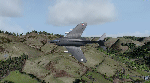
A series of markers around the famous "Mach Loop" in Wales to help sim flyers find and fly the
route.
The Mach Loop is a series of valleys in the United Kingdom in west-central Wales, notable for
their use as low-level training areas for fast aircraft. The system of valleys lies 13 km (8
mi) east of Barmouth between the towns of Dolgellau to the north and Machynlleth to the south,
from the latter of which it takes its name.
It is usually flown in an anti-clockwise direction.
Works in FSX and P3D.
| Filename: | Mach_Loop_Markers_Fast_Jets.zip |
| License: | Freeware |
| Added: | 10th October 2022, 14:02:20 |
| Downloads: | 85 |
| Author: | Peter J Forster |
| Size: | 2.31 MB |
| Category: Flight Simulator 2004 - Scenery | |
| Mt Taranaki/Egmont, NZ, Photoreal Scenery |
|
File Description:
40 x 50 kilometres of photo-real scenery. Fully autogenned, daytime summer textures only. (It will display throughout the year though.)
This showcases the amazing volcanic Mt Taranaki. Like many New Zealand mountains it has both a Maori and European name. Mt Taranaki dominates the Taranaki landscape, and is a spectacular example of of how the central North Island has been effected by volcanic activity.
This is a remake of the original Godzone Taranaki scenery adjusted to match the new elevaton meshes. It is best with the Geographx 20m elevation mesh, and the minimum recommended mesh is the Geographx 75m.
| Filename: | Mt_TaranakiEgmont_NZ__Photoreal_Scenery.zip |
| License: | Freeware, limited distribution |
| Added: | 16th January 2006, 05:57:36 |
| Downloads: | 4,873 |
| Author: | Robin Corn |
| Size: | 40.09 MB |
© 2001-2026 AVSIM Online
All Rights Reserved
Privacy Policy |