
Where Flight Simulation Enthusiasts Gather from Around the World!
AVSIM Library - Search Results

| Category: Flight Simulator 2004 - Scenery | |
| Nanisivik CYSR and Arctic Bay CJX7 in Nunavut, Canada |

|
Images related to this file:
File Description:
Nanisivik is an airfield in the north of Baffin Island, 470 miles north of the Arctic circle. It was built to service a zinc and lead mine that was opened in 1976 as Canada's first Arctic mine, now closed and dismantled. The deep water Strathcona Sound has been ear-marked by the Canadian government for development as a naval base, so I have left the large ore storage shed and the jetty in place. The airfield is at 2,106 feet on the top of the Borden Peninsula hills with a lighted 6,400 feet of 150 feet wide gravel runway runway aligned 11/29. There is a terminal and other maintenance buildings, and First Air have a building there from when the mine generated a lot of traffic and jets were used. Arctic Bay is a village 11 miles west of Nanisivik airfield with a population of around 690 which also uses the Nanisivik airfield. There is another gravel strip much closer to the village that is called Arctic Bay CJX7, but this is smaller with only 1,500' of 50' wide gravel and has no facilities of any sort. The village is partly dependent on visiting sports hunters and other limited tourist visits. At almost 73 degrees north the average year will have only four or even three months where the average high is above freezing. The buildings on the field have been modelled specifically for this scenery, and as in real life there is only JetA available. The AI visiting aircraft are a Kenn Borek Twin Otter and a First Air 42-300. As Nanisivik is in the "Northern Domestic Airspace" the runway is signed in "true" bearings and not magnetic as magnetic compasses become unreliable close to the magnetic pole.
| Filename: | Nanisivik_CYSR_and_Arctic_Bay_CJX7_in_Nunavut_Cana.zip |
| License: | Freeware, limited distribution |
| Added: | 28th May 2011, 19:59:18 |
| Downloads: | 494 |
| Author: | Roger Wensley |
| Size: | 2.64 MB |
| Category: Flight Simulator X - Scenery | |
| KMKJ - Mountain Empire Airport - Virginia, USA |
|
Images related to this file:
File Description:
Mountain Empire Airport (ICAO: KMKJ, FAA LID: MKJ) is a public use airport in Smyth County, Virginia, United States.[1] It located nine nautical miles (10 mi, 17 km) northeast of the central business district of Marion (in Smyth County)[1] and 13 nautical miles (15 mi, 24 km) west of Wytheville (in Wythe County).[2] The airport is situated between Interstate 81 and U.S. Route 11 (Lee Highway), near Groseclose. It is owned by Smyth Wythe Airport Commission.
This is a complete re-work of the airport. Added taxiway, additional parking aprons and custom buildings.
Created with Airport Design Editor by ScruffyDuck Software using current FAA documentation and Google Earth measurements, this package offers a replacement for FSX's stock airport. All these enhancements are as close to the real airport as I can get with stock library objects and custom buildings.
| Filename: | KMKJ__Mountain_Empire_Airport__Virginia_USA.zip |
| License: | Freeware |
| Added: | 25th January 2015, 15:55:52 |
| Downloads: | 308 |
| Author: | Wayne Roberts |
| Size: | 339.5 KB |
| Category: Flight Simulator X - Scenery | |
| YLEA Leeman, Western Australia (Snag Island) airstrip and town |
|
File Description:
YLEA Leeman - formerley Snag Island is a tiny fishing village which is ideal for fishermen and holiday makers eager to get away from the more commercialised centres. Calling itself the 'Home of Western Australia's Dhufish' the settlement boasts huge and dramatic white sand dunes, good beach and offshore fishing, safe beaches for surfing, swimming and sailboarding, and superb displays of wildflowers in the spring. Leeman is home to a crayfish (lobster) fishing fleet which plies the fishing grounds off the coast in the season. The industry developed in the 1950s and has since become one of the most important on the Central West coast. It is also a dormitory suburb for the nearby sand mining town of Eneabba. REQUIRES Blencowe_LibraryKit.zip
REQUIRES blencowe_librarykit_309494.zip (Available HERE)
| Filename: | YLEA_Leeman_Western_Australia_Snag_Island_airstrip.zip |
| License: | Freeware |
| Added: | 28th February 2013, 13:54:58 |
| Downloads: | 229 |
| Author: | Alan Blencowe |
| Size: | 1.39 MB |
| Category: Flight Simulator 2004 - Aircraft Repaints, Textures and Modifications | |
| Air Rhodesia, Vickers Viscount 700 circa 1979 |
|
Images related to this file:
File Description:
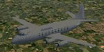
Air Rhodesia was originally formed as a subsidiary of Central African Airways in June 1964, but became an independent corporation on September 1, 1967. This V.748D (C/N 100) was built for CAA as VP-YNC and first flew on Thursday, 24 May 1956. In 1979 it was painted in grey anti-missile livery after a SAM attack on Viscount VP-YND (C/N 101), and fitted with deflectors on the engine jet pipes to try and prevent a SAM missile from locking on using its heat sensors. In conjunction with special operational procedures when climbing and descending, they achieved the desired safety effect: no more aircraft were lost to missile attacks. You need Rick Piper's Vickers Viscount 700 model which you can download at: http://www.cbfsim.org/cbfsim/cbfs_lib/displayimage.php?album=9&pos=0. Repaint by Andre Reimers.
| Filename: | Air_Rhodesia_Vickers_Viscount_700_circa_1979.zip |
| License: | Freeware |
| Added: | 21st May 2011, 18:20:39 |
| Downloads: | 106 |
| Author: | Andre Reimers |
| Size: | 657.12 KB |
| Category: Flight Simulator X - AFCAD Files | |
| The Ohio State University Airport (KOSU) |
|
File Description:
The Ohio State University Airport (OSU) is one of the leading general aviation facilities in the nation, providing educational opportunities to university students and aircraft services to many of central Ohio's pilots and businesses.
The OSU Airport is home to 230 aircraft, including single- and multi-engine, piston and turbine engine aircraft and rotorcraft. The OSU Airport oversees an estimated 100,000 operations per year, including corporate activity, student training, and pleasure flying. By comparison, the OSU Airport generally ranks in the top five airports in Ohio in the number of take-offs and landings with Cleveland Hopkins, Port Columbus, Dayton, and Cincinnati Lunken.
This file includes enhancements to KOSU taxiways and aprons, adds additional airport scenery/buildings, and increases the available parking from 15 ramps in the stock FSX airport to over 180+ ramps (based on actual airport parking).
| Filename: | The_Ohio_State_University_Airport_KOSU.zip |
| License: | Freeware, limited distribution |
| Added: | 19th January 2008, 13:27:57 |
| Downloads: | 924 |
| Author: | Tom Bastress |
| Size: | 16.12 KB |
| Category: Prepar3D V1-4 - Aircraft Repaints, Textures and Modifications | |
| Qantas Empire Airways Douglas C-47 (VH-EAL) |
|
Images related to this file:
File Description:
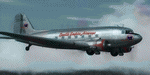
This folder contains a repaint for version 3.14 of the Douglas C-47 by Manfred Jahn and colleagues in the colors of VH-EAL of Qantas Empire Airways. Originally C-47A-20-DK c/n 13084 42-93199, it flew with the RAAF as A65-49 VH-CIE before joining Qantas in 1946 as VH-EAL (this paint), and later VH-EBH and VH-EBW. It went to Brain & Brown as VH-BAA (an earlier paint) in 1960 and flew with them until 1979. It was then taken to the Warbirds Aviation Museum in Mildura, but was moved to Alice Springs in 1995 to join the Central Australian Aviation Museum, where it is now painted in the colors of VH-EWE of Connair. Repaint by Jan Kees Blom for Manfred Jahn's C-47 version 3, based on the paintkit by Gman5250.
| Filename: | Qantas_Empire_Airways_Douglas_C47_VHEAL.zip |
| License: | Freeware |
| Added: | 9th September 2018, 03:43:43 |
| Downloads: | 325 |
| Author: | Jan Kees Blom |
| Size: | 17.66 MB |
| Category: Flight Simulator X - Scenery | |
| KMFV - Accomack County Airport - Melfa, Virginia, USA |
|
Images related to this file:
File Description:
Accomack County Airport (IATA: MFV, ICAO: KMFV) is a county-owned public-use airport located 1 mile (1.6 km) west of the central business district of Melfa. The airport was built by the United States Army Air Forces about 1942, and was known as Melfa Flight Strip. It was an emergency landing airfield for military aircraft on training flights. It was closed after World War II, and was turned over for local government use by the War Assets Administration (WAA).
This is a complete re-work of the airport with added taxiways, parking and custom buildings. Created with Airport Design Editor by ScruffyDuck Software using current FAA documentation and Google Earth measurements, this package offers a replacement for FSX's stock airport. All these enhancements are as close to the real airport as I can get with stock library objects and custom buildings.
| Filename: | KMFV__Accomack_County_Airport__Melfa_Virginia_USA.zip |
| License: | Freeware |
| Added: | 16th February 2015, 11:56:40 |
| Downloads: | 427 |
| Author: | Wayne Roberts |
| Size: | 292.84 KB |
| Category: Flight Simulator X - AFCAD Files | |
| MROC - Juan Santamaria International Airport - San Jose, Costa Rica |
|
Images related to this file:
File Description:
Juan SantamariÂa International Airport (Spanish: Aeropuerto Internacional Juan Santamaria) (IATA: SJO, ICAO: MROC) is the primary airport serving San Jose, the capital of Costa Rica. It is the busiest airport in the country and the second busiest in Central America. The airport serves as a hub for Avianca Costa Rica(formerly TACA) and Sansa and a focus city for Copa Airlines.
Features:
*Taxiways properly designed and signs updated
*Expanded parking apron
*Redesigned terminal building to match most recent renovations
*Relocated control tower (old one was demolished)
*Accurate gate assignments
*Runway markings and lighting corrected
*Parking spots for commercial traffic
*Separate parking area for GA traffic
*Misc airport buildings added
*Cargo ramp
*Airport vehicles and objects throughout the airport
*Fuel service vehicles
*Static aircraft
| Filename: | MROC__Juan_Santamaria_International_Airport__San_J.zip |
| License: | Freeware |
| Added: | 8th July 2014, 03:40:05 |
| Downloads: | 1,519 |
| Author: | Jaison Diaz / Endeavour AI |
| Size: | 97.25 KB |
| Category: Flight Simulator X - Scenery | |
| JZZ - Koliganek Airport - Alaska, USA |
|
Images related to this file:
File Description:
Koliganek Airport (IATA: KGK, ICAO: PAJZ, FAA LID: JZZ) is a state-owned, public-use airport located one nautical mile (1.85 km) east of the central business district of Koliganek,in the Dillingham Census Area of the U.S. state of Alaska. Scheduled airline service to Dillingham Airport is provided by Peninsula Airways (PenAir).The airport opened in 1997.
Increased length of runway 9/27 from 3,000 feet to 3,300 feet.Added runway 17/35 (3,300 feet and 75 feet wide). Changes were based on 2011 construction plans.
Created with Airport Design Editor 9x by ScruffyDuck Software using current FAA documentation and Google Earth measurements, this package offers a replacement for FSX's stock airport. All these enhancements are as close to the real airport as I can get with stock library objects and custom buildings.
| Filename: | JZZ__Koliganek_Airport__Alaska_USA.zip |
| License: | Freeware |
| Added: | 25th December 2014, 01:15:29 |
| Downloads: | 597 |
| Author: | Wayne Roberts |
| Size: | 214.91 KB |
| Category: Prepar3D V1-4 - Scenery | |
| Panmunjom Corea N37.55.98 E126.41.23 |
|
File Description:
Panmunjom Corea N37.55.98 E126.41.23. It is a village on the border between North Korea and South Korea, where the 1953 armistice was signed which ended the Korean War. President Moon Jae-in of the Republic of Korea and the chairman of the State Democratic People's Republic of Korea Commission Kim Jong Un held an inter-Korean Summit at the 'House of Peace' in Panmunjom on 27 April 2018.
Within the downloaded package you will find readme files for scenery installation. Good fly VFR. Pasquale Marrulli.
| Filename: | Panmunjom_Corea_N375598_E1264123.zip |
| License: | Freeware |
| Added: | 6th May 2018, 01:05:06 |
| Downloads: | 108 |
| Author: | Pasquale Marrulli |
| Size: | 290.7 KB |
© 2001-2026 AVSIM Online
All Rights Reserved
Privacy Policy |