
Where Flight Simulation Enthusiasts Gather from Around the World!
AVSIM Library - Search Results

| Category: Flight Simulator 2002 - Original Aircraft | |
| Lockheed Hercules C130J (v.2) |

|
File Description:
The Lockheed C130 J Hercules is the newest version of the trusty military transport aircraft. With its six-blade propellers and more powerful engines, it can fly higher, faster and further than any previous Hercules. This is my second version of this aircraft (with more than 11 000 downloads of the first one) with an all-new FSDS model. It features animation of all control surfaces, landing gear and propellers; full lighting effects; opening front door and rear cargo ramp as well as a pilot getting into- and out of the aircraft as it takes off and a flight attendant opening and closing the front door. The panel is a photo-realistic rendition, designed from photographs downloaded from the Lockheed-Martin website. It includes a Heads Up Display ("HUD"), WORKING radar unit and Multi Function Display ("MFD") for the engine-instruments ("EICAS"). A sound pack is also included. An experienced Hercules pilot checked the flight dynamics to ensure that flying this aircraft is AS REAL AS IT GETS!
| Filename: | Lockheed_Hercules_C130J_v2.zip |
| License: | Freeware |
| Added: | 1st January 2003, 13:49:53 |
| Downloads: | 8,243 |
| Author: | Vasco Ferreira |
| Size: | 8.99 MB |
| Category: Flight Simulator 2004 - Scenery | |
| Himalayas LOD9 Base Mesh, Volume 1 - Southeastern Ranges |
|
Images related to this file:
File Description:
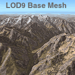
Detailed terrain mesh of the Southeastern Himalayan Ranges, N26-32 E90-98. The files in this package are based on Shuttle Radar (SRTM) Version 2 data but with many of the void areas, especially the most significant sections, filled with elevation data generated from topographic maps by Jonathan de Ferranti. While Jonathan's work is unrelated to flight simulation he kindly gave me permission to compile his data for use in FS. The result is a wonderful improvement in detail and accuracy over any existing mesh file, freeware or commercial, based on SRTM or DTED data alone.
Due to the large area of the Himalayas I've compiled the source data as two separate series: the "Himalayan Peaks" series covers prominent mountains and ranges in higher detail and locally overrides any existing LOD9 terrain mesh. In addition, a LOD9 "base mesh" series, with LOD8 and LOD7 "buffer" mesh files, covering the entire Himalayas, is meant for those who do not yet have an add-on terrain mesh of these beautiful mountains.
| Filename: | Himalayas_LOD9_Base_Mesh_Volume_1__Southeastern_Ra.zip |
| License: | Freeware, limited distribution |
| Added: | 29th May 2010, 09:01:26 |
| Downloads: | 10,298 |
| Author: | Holger Sandmann, Jonathan de Ferranti |
| Size: | 71.82 MB |
| Category: Flight Simulator 2004 - Aircraft Repaints, Textures and Modifications | |
| USAF/MATS Convair CV-240 VBF |
|
Images related to this file:
File Description:

FS2004 USAF/MATS Convair CV-240 VBF in colors of 1952. The Convair with cn 264 was one of a bunch of T-29B-CO (CV-240-27) delivered to the U.S. Air Force September 16, 1952 and on July 15, 1953 assigned to the 1299 Transport Squadron of Military Air Transport Service (MATS). She was equipped with standard high density seating for staff transport and painted in the typically MATS livery of the early fifties. On July 13, 1956 she was converted to VC-131A standard and fitted with the weather mapping radar used extensively on the model CV-440 and on many CV-340 models. The last operator of this Convair was the 86th Tactical Fighter Wing based at Stuttgart (Germany). She came to AMARC on May 06, 1975 and was sold off for scrap on November 23, 1994. Textures and associated model file included only. Requires cv240VBFmilitary_basepack_010.ZIP. Original by Greg Pepper & Tom Gibson, upgraded by Georg Hauzenberger (model) and Hans Hermann (textures) Virtual Birds Factory, March 2011
| Filename: | USAFMATS_Convair_CV240_VBF.zip |
| License: | Freeware, limited distribution |
| Added: | 29th March 2011, 00:54:27 |
| Downloads: | 814 |
| Author: | Georg Hauzenberger and Hans Hermann |
| Size: | 4.76 MB |
| Category: Flight Simulator 2004 - Scenery | |
| Himalayas LOD9 Base Mesh, Volume 2 - Southcentral Ranges |
|
Images related to this file:
File Description:

Detailed terrain mesh of the Southcentral Himalayan Ranges, N26-32 E82-90. The files in this package are based on Shuttle Radar (SRTM) Version 2 data but with many of the void areas, especially the most significant sections, filled with elevation data generated from topographic maps by Jonathan de Ferranti. While Jonathan's work is unrelated to flight simulation he kindly gave me permission to compile his data for use in FS. The result is a wonderful improvement in detail and accuracy over any existing mesh file, freeware or commercial, based on SRTM or DTED data alone.
Due to the large area of the Himalayas I've compiled the source data as two separate series: the "Himalayan Peaks" series covers prominent mountains and ranges in higher detail and locally overrides any existing LOD9 terrain mesh. In addition, a LOD9 "base mesh" series, with LOD8 and LOD7 "buffer" mesh files, covering the entire Himalayas, is meant for those who do not yet have an add-on terrain mesh of these beautiful mountains.
| Filename: | Himalayas_LOD9_Base_Mesh_Volume_2__Southcentral_Ra.zip |
| License: | Freeware, limited distribution |
| Added: | 29th May 2010, 09:05:56 |
| Downloads: | 9,447 |
| Author: | Holger Sandmann, Jonathan de Ferranti |
| Size: | 90.25 MB |
| Category: Flight Simulator 2004 - Scenery | |
| Himalayas LOD9 Base Mesh, Volume 4 - Kashmir and Jammu |
|
File Description:
Detailed terrain mesh of the Kashmir and Jammu Ranges, N30-39 E76-78. The files in this package are based on Shuttle Radar (SRTM) Version 2 data but with many of the void areas, especially the most significant sections, filled with elevation data generated from topographic maps by Jonathan de Ferranti. While Jonathan's work is unrelated to flight simulation he kindly gave me permission to compile his data for use in FS. The result is a wonderful improvement in detail and accuracy over any existing mesh file, freeware or commercial, based on SRTM or DTED data alone.
Due to the large area of the Himalayas I've compiled the source data as two separate series: the "Himalayan Peaks" series covers prominent mountains and ranges in higher detail and locally overrides any existing LOD9 terrain mesh. In addition, the LOD9 "base mesh" series, with LOD8 and LOD7 "buffer" mesh files, covering the entire Himalayas, is meant for those who do not yet have an add-on terrain mesh of these beautiful mountains.
| Filename: | Himalayas_LOD9_Base_Mesh_Volume_4__Kashmir_and_Jam.zip |
| License: | Freeware, limited distribution |
| Added: | 22nd February 2006, 20:32:50 |
| Downloads: | 7,503 |
| Author: | Holger Sandmann, Jonathan de Ferranti |
| Size: | 29.24 MB |
| Category: Flight Simulator 2004 - Scenery | |
| Himalayas LOD9 Base Mesh, Volume 3 - Southwestern Ranges |
|
Images related to this file:
File Description:

Detailed terrain mesh of the Southwestern Himalayan Ranges, N28-37 E78-82. The files in this package are based on Shuttle Radar (SRTM) Version 2 data but with many of the void areas, especially the most significant sections, filled with elevation data generated from topographic maps by Jonathan de Ferranti. While Jonathan's work is unrelated to flight simulation he kindly gave me permission to compile his data for use in FS. The result is a wonderful improvement in detail and accuracy over any existing mesh file, freeware or commercial, based on SRTM or DTED data alone.
Due to the large area of the Himalayas I've compiled the source data as two separate series: the "Himalayan Peaks" series covers prominent mountains and ranges in higher detail and locally overrides any existing LOD9 terrain mesh. In addition, the LOD9 "base mesh" series, with LOD8 and LOD7 "buffer" mesh files, covering the entire Himalayas, is meant for those who do not yet have an add-on terrain mesh of these beautiful mountains.
| Filename: | Himalayas_LOD9_Base_Mesh_Volume_3__Southwestern_Ra.zip |
| License: | Freeware, limited distribution |
| Added: | 30th May 2010, 10:00:26 |
| Downloads: | 155,808 |
| Author: | Holger Sandmann, Jonathan de Ferranti |
| Size: | 62.16 MB |
| Category: Flight Simulator 2004 - Scenery | |
| Himalayas LOD9 Base Mesh, Volume 5 - Hindu Kush and Pamir |
|
Images related to this file:
File Description:

Detailed terrain mesh of the Hindu Kush and Pamir Ranges, N32-40 E70-76. The files in this package are based on Shuttle Radar (SRTM) Version 2 data but with many of the void areas, especially the most significant sections, filled with elevation data generated from topographic maps by Jonathan de Ferranti. While Jonathan's work is unrelated to flight simulation he kindly gave me permission to compile his data for use in FS. The result is a wonderful improvement in detail and accuracy over any existing mesh file, freeware or commercial, based on SRTM or DTED data alone.
Due to the large area of the Himalayas I've compiled the source data as two separate series: the "Himalayan Peaks" series covers prominent mountains and ranges in higher detail and locally overrides any existing LOD9 terrain mesh. In addition, the LOD9 "base mesh" series, with LOD8 and LOD7 "buffer" mesh files, covering the entire Himalayas, is meant for those who do not yet have an add-on terrain mesh of these beautiful mountains.
| Filename: | Himalayas_LOD9_Base_Mesh_Volume_5__Hindu_Kush_and_.zip |
| License: | Freeware, limited distribution |
| Added: | 29th May 2010, 08:57:29 |
| Downloads: | 7,603 |
| Author: | Holger Sandmann, Jonathan de Ferranti |
| Size: | 85.72 MB |
| Category: Flight Simulator 2004 - Original Aircraft | |
| Lockheed L-1049 Super G Constellation |
|
Images related to this file:
File Description:

Lockheed L-1049G Super Constellation V2 - This re-uploaded version integrates the changes of the 20 May 2009 Update pack released elsewhere.
First flown in December 1954, the "Super G" was the most successful and
prestigious civil variant of Lockheed's Super Constellation series. It could
carry up to 99 passengers, and optional wing-tip tanks holding 600 gallons
each enabled it to comfortably fly the popular long-distance routes.
Included in the package are four models representing aircraft with and
without radar noses and tip tanks.
Natural metal TWA and Eastern textures by
Eric Joiner, KLM texture by Marcel Ritzema, panel textures and additional
gauges by Diego S. Barreto. Model, VC, and texture basics by Manfred Jahn,
panels, gauges, and animations by Hansjoerg Naegele, flight dynamics by Luis
Pallas, wingview angles by Bill Tyne and Andreas Trapp, lights and exhaust
effects by Roland Berger, checklist and documentation by Volker Boehme,
flight test and handling research by Stefan Werner. The 1049 project is
hosted by Tom Gibson's Calclassic forum at
http://calclassic.proboards55.com.
| Filename: | Lockheed_L1049_Super_G_Constellation.zip |
| License: | Freeware |
| Added: | 11th December 2009, 00:50:19 |
| Downloads: | 7,737 |
| Author: | Manfred Jahn and Team 1049 |
| Size: | 31.33 MB |
| Category: X-Plane - Utilities | |
| XTouchDownRecorder V7 |
|
File Description:
XTouchDownRecorder
Improve your landing skill? This is the plugin you must have
X-Plane 10/11 aircraft landing touch down flight recorder
it is used for aircraft landing data analysis
it supports Windows, Mac, Linux x64 only
Feature
touch ground times
landing fpm, pitch, G force, ground speed
max fpm,pitch, G force around landing, ground speed
landing log will be automatically written to log file XTouchDownRecorderLog.txt
automatically pop up while you are taxing
button/key assignment
mouse movable chart window
Installation
unzip and move XTouchDownRecorder to X-Plane 11\Resources\plugins\
re-start X-Plane
check X-Plane Plugin menu, there will be a "XTouchDownRecorder"
even if your airplane touched the ground several times, XTouchDownRecorder will give you a beautiful chart for landing analsysis
Joystick button/key assignment
assign button/key to cpuwolf/XTouchDownRecorder/Toggle TouchDownRecorder Chart
Support Me
https://www.paypal.me/cpuwolf
https://www.patreon.com/cpuwolf
Contact
http://x-plane.vip/
QQ群:378072629
| Filename: | XTouchDownRecorder_V7.zip |
| License: | Freeware |
| Added: | 28th December 2018, 00:13:51 |
| Downloads: | 107 |
| Author: | Wei Shuai |
| Size: | 395.52 KB |
| Category: X-Plane - Utilities | |
| XTouchDownRecorder V8 |
|
File Description:
XTouchDownRecorder Improve your landing skill? This is the plugin you must have X-Plane 10/11 aircraft landing touch down flight recorder it is used for aircraft landing data analysis it supports Windows, Mac, Linux x64 only Feature touch ground times landing fpm, pitch, G force, ground speed max fpm,pitch, G force around landing, ground speed landing log will be automatically written to log file XTouchDownRecorderLog.txt automatically pop up while you are taxing button/key assignment mouse movable chart window Installation unzip and move XTouchDownRecorder to X-Plane 11\Resources\plugins\ re-start X-Plane check X-Plane Plugin menu, there will be a "XTouchDownRecorder" even if your airplane touched the ground several times, XTouchDownRecorder will give you a beautiful chart for landing analsysis Joystick button/key assignment assign button/key to cpuwolf/XTouchDownRecorder/Toggle TouchDownRecorder Chart Support Me https://www.paypal.me/cpuwolf https://www.patreon.com/cpuwolf Contact http://x-plane.vip/ QQ群:378072629
| Filename: | XTouchDownRecorder_V8.zip |
| License: | Freeware |
| Added: | 16th January 2019, 23:29:37 |
| Downloads: | 97 |
| Author: | Wei Shuai |
| Size: | 674.97 KB |
© 2001-2026 AVSIM Online
All Rights Reserved
Privacy Policy |