
Where Flight Simulation Enthusiasts Gather from Around the World!
AVSIM Library - Search Results

| Category: Fly! II - Scenery | |
| Los Angeles International Airport (KLAX) - v2.0 |

|
File Description:
TerraModels Scenery Development System by Allen Kriesman was used to create the scenery for Los Angeles International Airport (KLAX), California - version 2. Biber Salsa models were also used to create this scenery. No custom models were created for this scenery. There are dynamic vehicles moving in this scenery.
| Filename: | Los_Angeles_International_Airport_KLAX__v20.zip |
| License: | Freeware |
| Added: | 13th March 2003, 02:48:24 |
| Downloads: | 619 |
| Author: | Wayne Roberts |
| Size: | 650.31 KB |
| Category: Flight Simulator 2004 - Scenery | |
| Long Island Mac Arthur Airport, Islip, New York (KISP) |
|
File Description:
This scenery is built for FS2004. This scenery was created with Abacus EZ Scenery. You will need the RWY12 Libraries installed as well as a few EZ scenery libraries (see readme). This scenery adds many many things, including a terminal replacement, parking spots, and vehicles, GA Hangars, and more.
| Filename: | Long_Island_Mac_Arthur_Airport_Islip_New_York_KISP.zip |
| License: | Freeware |
| Added: | 3rd March 2008, 01:49:52 |
| Downloads: | 2,703 |
| Author: | Brandon DePalo and Ray Lunning / Watsup Sceneries |
| Size: | 2.55 MB |
| Category: Flight Simulator 2004 - Scenery | |
| Cleveland Hopkins International Airport (KCLE) |
|
Images related to this file:
File Description:

Scenery upgrade for the Cleveland Hopkins International Airport scenery (CLE2004). This upgrade extends the runway 6L/24R to its full length, and also builds in some small fixes. (Requires installation of scenery CLE2003 and CLE2004u. See readme for details) [NOTE: Reupload of previous scenery - not a new scenery]
| Filename: | Cleveland_Hopkins_International_Airport_KCLE.zip |
| License: | Freeware, limited distribution |
| Added: | 8th January 2010, 21:02:19 |
| Downloads: | 8,333 |
| Author: | Shehryar Ansari |
| Size: | 177.13 KB |
| Category: Flight Simulator 2004 - Scenery Design | |
| Oil Rig #2 |
|
File Description:
Scenery Object for placement using such programes as EZ-Scenery
| Filename: | Oil_Rig_2.zip |
| License: | Freeware |
| Added: | 27th August 2008, 00:08:23 |
| Downloads: | 573 |
| Author: | Godfrey Tier |
| Size: | 310.26 KB |
| Category: Flight Simulator 2004 - Scenery Design | |
| Wool/Hay Bales |
|
Images related to this file:
File Description:
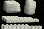
Scenery object for use in program such as EZ-Scenery.
| Filename: | WoolHay_Bales.zip |
| License: | Freeware |
| Added: | 2nd September 2011, 23:37:21 |
| Downloads: | 206 |
| Author: | Godfrey Tier |
| Size: | 47.38 KB |
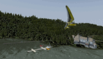
| Category: Flight Simulator X - Utilities | |
| NSW Heli spots for HeliTraffic |
|
Images related to this file:
File Description:

NSW Heli spots for HeliTraffic 2009 by Flight 1, Covers OZx scenery, FTX scenery & Standard FSX scenery. Requires HeliTraffic 2009 by Flight 1
| Filename: | NSW_Heli_spots_for_HeliTraffic.zip |
| License: | Freeware |
| Added: | 5th December 2011, 08:44:32 |
| Downloads: | 171 |
| Author: | Matt Levi |
| Size: | 6.37 KB |
| Category: Flight Simulator X - Scenery Design | |
| (Version 2.0) KEFD -Ellington 2025 Refresh FSX (Circa 2006-2010)- Johnson Space Center Houston |
|
Images related to this file:
File Description:
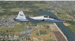
Version 2.0 covers landclass across the entire greater Houston area, with a large increase in LOD. This version significantly tightens up and improves the landclass from version 1.0, and adds a vast amount of scenery objects that brings the Bay Area-KEFD area into the modern era. This improves and adds a highly accurate runway 17 approach with accurate placement of buildings and scenery around the year 2011-modern day. In addition, includes several new files including a new airport/helipad via Houston Clear lake regional airport, T41 La Porte Municipal and surrounding shipping ports, Kemah Boardwalk, and a giant improvement to Johnson Space Center Houston. Rundway 35 and Runway 22 landclass is significantly increased, and more accurate as well. You can fly an accurate VFR approach or set up an ILS for any one of KEFD's runways with ease with this improvement.List of Version 2.0 additions and changes: - I added a ton of scenery objects and tightened up the landclass at Johnson Space Center Houston- NASA Control Center--- Added Talon Park with T38s (via static objects)--- Added Gemeni V rocket and 747 for the shuttle transporter--- And a whole bunch of vegetation, new buildings, and tour buses.- Added Kemah boardwalk and several boat docks- Removed a TON of highrise textures and replaced with medium and large city suburb landclass.- Added Clear Lake regional Hospital with helipad and surrounding scenery by Walter Reed Park- Added El Jardin or "Bayport Container port" with several scenery objects and significantly tightened up landclass.-- Looks great when setting up ILS approach for RWY 22- Tightened up Bay Area BLVD landclass, "adding" University of Houston Clear Lake"-- UHCL was semi already present, just made it more pronounced.- Made Red Bluff road landclass super recognizable!-- Red Bluff road is used to set up VFR approach and or field break for RWY 22 and RWY 17 R.----- Its common to see private jets and the USAF doing a break along Red Bluff road.- Added First Baptist Church, and water tower to Pasadena Convention center- Made Fairmont Parkway pronounced with landclass- Added Houston Port Authority at Morgan's Point--- Another Landmark for the RWY 22 ILS approach, NASA religiously uses this to line up the 10 mile ILS.- Tightened up landclass at Village Grove East and along Fairmont Parkway- Added a TON of scenery objects and landclass corrections for approach of RWY 17 L and 17 R.---- Added Home Depot, Lowes, Walmart Super center, Guitar center etc.---- added South Main Baptist Church--- Bondy Jr High, Turner Elementary, and Pasadena Memorial High School--- Added Saint Luke's Hospital--- Added Hampton Inn Suites and HCA rehab hospital--- Added a ton to the container facility behind best buy and storage facility--- Added smaller churches on RWY 17 approach--- Added a ton of scenery at the base of RWY 17 R, i.e., concrete plant, containers, trucks-- Added gas stations on the corner of beltway 8 and genoa red bluff-- Significantly changed and tightened up landclass at the base of RWY 22 and RWY 17 L and 17 R-- Made several roads and Beltway pronounced------ This decision looks AWESOME at night, really adds demarcation to the roads.**All of this makes the RWY 17 approach super recognizable** RWY 22 approach landclass is much more accurate.- Significantly changed and tightened up landclass near southbelt ellington and interstate 45.- Added Grace Church-- I wanted to do San Jacinto College south, but seemed over kill at that point.- SIGNIFICANTLY tightened up landclass for RWY 35 approach and near baybrook mall.-- Along I45- Added TDECU stadium at the University of Houston Main Campus---- So you can practice flybys for Cougar games!- Added the Battleship at San Jacinto Monument- I also "borrowed" T41 La Porte Municipal's tower camera to make a SWEET view of KEFD.- I included landclass for Sealy Texas this time, as well as my significant enhancements of Austin, Texas greater area as well (optional, but recommended!)---------------------------------------------------------------------------Version 1.0 originally added:- Added the Johnson Space Center Houston, which is now greatly enhanced and blended.- San Jacinto Community College-Central- Pasadena Convention Center- Pasadena Water Treatment Facility- NASA Bouncy Lab- Pasadena Shopping center, now greatly enhanced and blended.- Baybrook Mall and other shopping spots.- Significant Landclass improvements across the entire greater Houston Area File also includes landclass and scenery improvements for the greater Austin, Texas Area (optional), KIAH, KDWH, and Sealy, Texas. Each of these projects combined covers roughly 15,000 square miles of landclass improvement. Allowing you to fly entirely from Houston to Austin, or Houston to San Antonio in accurate landclass. -Enjoy!DJN
| Filename: | Version_20_KEFD_Ellington_2025_Refresh_FSX_Circa_2.zip |
| License: | Freeware |
| Added: | 12th October 2025, 16:15:47 |
| Downloads: | 66 |
| Author: | Dan Nelson |
| Size: | 277.28 MB |
| Category: Fly! II - Scenery | |
| Mineta San Jose International Airport (KSJC) - v2.0 |
|
File Description:
TerraModels Scenery Development System by Allen Kriesman was used to create the scenery for Mineta San Jose International Airport (KSJC), California. Biber Salsa models were also used to create this scenery. Taxiway signs have been included. No custom models were created for this scenery. There are dynamic vehicles in this scenery.
| Filename: | Mineta_San_Jose_International_Airport_KSJC__v20.zip |
| License: | Freeware |
| Added: | 2nd June 2003, 23:47:22 |
| Downloads: | 238 |
| Author: | Wayne Roberts |
| Size: | 348.42 KB |
| Category: Flight Simulator X - Scenery | |
| "Womack Resort at Bull Run Lake" |
|
Images related to this file:
File Description:
An addon scenery area for use with Microsoft FSX and the ORBX "FTX NA BLUE" Pacific Northwest scenery package. Includes scenery created with the Flight 1 Instant Scenery maker. You will need Runway 12 object libraries and other object libraries to see this scenery. Copyright 2010 by Brad Allen. FREEWARE ONLY.
| Filename: | Womack_Resort_at_Bull_Run_Lake.zip |
| License: | Freeware |
| Added: | 18th March 2010, 09:15:48 |
| Downloads: | 763 |
| Author: | Brad Allen |
| Size: | 217.44 KB |
| Category: Fly! II - Scenery | |
| Deblois Flight Strip (43B) |
|
File Description:
TerraModels Scenery Development System by Allen Kriesman was used to create the scenery for Deblois Flight Strip (43B), Maine. Biber Salsa models were also used to create this scenery. No custom models were created for this scenery.
| Filename: | Deblois_Flight_Strip_43B.zip |
| License: | Freeware |
| Added: | 4th June 2003, 02:12:10 |
| Downloads: | 113 |
| Author: | Wayne Roberts |
| Size: | 131.06 KB |
© 2001-2026 AVSIM Online
All Rights Reserved
Privacy Policy |