
Where Flight Simulation Enthusiasts Gather from Around the World!
AVSIM Library - Search Results

| Category: Flight Simulator X - AFCAD Files | |
| Greenwood Lake Airport (4N1), NJ |

|
File Description:
Located 01 miles E of West Milford, New Jersey on 150 acres of land, Greenwood Lake Airport is a public asphalt strip that services small to medium GA air traffic. The second runway that used to be there has been re-paved and now serves as extra aircraft parking. You can park anywhere on the closed runway, along the edge of the main tarmac where the terminal building is, or between any two white cones (50 foot max wingspan) that mark tie-down locations in the middle of the main tarmac. A helicopter start is provided as well. For parking, Small GA spaces are for craft with wingspans of less than 50 feet; Medium GA spaces are for craft with wingspans from 50-60 feet. The glide slope for Runway 24 has been adjusted up from 3.5 degrees to 4 degrees as in real life the runway sits higher than the ground the trees grow from so this will give you proper clearance on approach. Fuel is available by stopping near the tank on the main tarmac. Scenery constructed with use of satellite images/streetview/aerial photos - the author has not been there in person. This scenery is meant to be used in conjunction with MegaScenery Earth New York 005. It is not required, but apron use is minimized to allow satellite scenery to show through as much as possible, and objects are placed based on the MSE textures - lack of it may make scenery look out of place.
| Filename: | Greenwood_Lake_Airport_4N1_NJ.zip |
| License: | Freeware |
| Added: | 22nd July 2011, 03:59:26 |
| Downloads: | 479 |
| Author: | Drew Sikora |
| Size: | 1.98 MB |
| Category: Flight Simulator X - Helicopters | |
| CH-47D Chinook Hellenic Army Aviation |
|
File Description:
Greece has 15 CH-47D. The 9 of them are upgraded CH-47C to CH-47DG in 1995. The other 6 are CH-47SD. In 1980 Greece ordered 10 CH-47C Chinook. The first arrived in Greece in 1983. The first Greek Chinooks formally were belonged to Iran but after the fallen of Shahs, they were given to Greece. In 1984 took place the first accident of the Greek Chinooks when the ÅÓ-006 had a heavy landing in Samos Island, during the transportation of a radar. After that the 006 was used as a source. The other 9 in the period of 1992-1994 were upgraded to D (Super D). After the Imia night, the Greek Government wanted to order 11 Chinooks helicopter, 9 SD and 2 SD for the Special Forces. Later 7 Chinooks were ordered. They have analogue cockpit and not glass cockpit in order to be same with the old DG. Also they have the better engine T55-L714A (4.868hp). This Chinook package is only for the FSX, but in case you want to fly it on your FS2004,then the majority of the Gauges will not be appeared. The package is complete. Features: model, Virtual Cockpit, new Panel, Sounds, rework Flight Dynamics, two Textures olive green and a dessert camo. The Original Model belongs to Mark Adams & Tom Woods, the reworked Flight Dynamics to Marwan Latif. The textures represent the olive green witch have now the Hellenic Chinooks and the dessert witch appeared until the upgraded of the CH-47C to CH-47DG.
| Filename: | CH47D_Chinook_Hellenic_Army_Aviation.zip |
| License: | Freeware, limited distribution |
| Added: | 3rd January 2007, 19:23:13 |
| Downloads: | 15,891 |
| Author: | Thanasis Delizisis, Panagiotis Delizisis |
| Size: | 10.75 MB |
| Category: Flight Simulator X - Scenery | |
| Whale Island (Hi Resolution Photo and mesh), New Zealand |
|
Images related to this file:
File Description:
Whale Island (Maori Name: Moutohora) is a small island located off the Bay of Plenty coast of New Zealand's North Island. It is located about 12 kilometers north of the town of Whakatane. A whaling station existed on the island during the 19th century. The 1.43 km island is a remnant of a complex volcano which has eroded, leaving two peaks. This is still an area of volcanic activity and there are hot springs on the island in Sulphur Valley, McEwans Bay, and Sulphur Bay.
This Hi Resolution scenery was created from a 0.25m pixel resolution Ortho-rectified Aerial mosaic owned by Environment Bay of Plenty (The Bay of Plenty Regional Council) and flown in 2007. The imagery has been slightly de-sampled for use in Flight Simulator X and utilizes the a custom hi resolution 5m Mesh derived from photogrammetry data off the photos. The textures are intended for summer daylight flying only, although due to the evergreen nature of New Zealand's native bush, the Islands appearance remains relatively constant throughout the year.
The island contains a small helicopter pad which is used for checking the various radio antennas on the Island. There is also a small Department of Conservation hut near the south western tip of the Island. These objects have been added from the FSX library of objects. Make sure to turn up your graphics sliders to make the most of this data! To find the Island fly north from Whakatane airport.
| Filename: | Whale_Island_Hi_Resolution_Photo_and_mesh_New_Zeal.zip |
| License: | Freeware, limited distribution |
| Added: | 20th January 2010, 10:12:14 |
| Downloads: | 4,650 |
| Author: | Tim Barnes |
| Size: | 9.94 MB |
| Category: Flight Simulator X - Scenery | |
| KAFW Fort Worth Alliance Airport - Texas, US |
|
Images related to this file:
File Description:
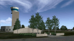
Ft. Worth Alliance Airport opened in 1989 and was billed as the world's first purely industrial airport. It is located around 14 miles North of the central business district of Ft. Worth and is also nearby the Dallas/Ft. Worth International Airport (KDFW). The airport serves general aviation, corporate jet, cargo, and military air traffic on a daily basis and it's proximity to the Texas Motor Speedway (only a few miles) brings extra dense traffic on race weekends. The airport is home to the American Airlines 777 and 767 maintenance base, FedEx Southwest Regional Sort Hub, Bell-Helicopter Training Center, DEA Air Operations Center and DynCorp International. Sadly the American Airlines maintenance base is set to close at the end of 2012 but is being kept alive in FSX!
This scenery features custom 3d buildings and objects bringing you a very accurate rendition of Ft. Worth Alliance Airport. Requires FSX Acceleration for the all scenery objects to display correctly.
Note: These files MUST be installed for the scenery to work correctly (otherwise there will be missing scenery objects at the airport):
-Filename: fsx_lts.zip - Ramp Lighting for FSX by Jim Dhaenens
-Filename: dlfcorelibraries2fsx.zip - Dan French Core Library Vol. 2
-Filename: lightstoo.zip - Jim Dhaenens Airfield Lighting
-Filename: objlib-jgse-fsx.zip - John Stinstrom JGSE Yellow Objects - this newer file replaces the older FS9 libraries with FSX versions
-Filename: objlib-ggse-fsx.zip - John Stinstrom GGSE Green Objects - this file also replaces FS9 libraries with FSX versions
| Filename: | KAFW_Fort_Worth_Alliance_Airport__Texas_US.zip |
| License: | Freeware, limited distribution |
| Added: | 12th December 2012, 16:56:36 |
| Downloads: | 2,932 |
| Author: | Brandon Thetford |
| Size: | 439.24 MB |
| Category: Flight Simulator X - Aircraft Repaints, Textures and Modifications | |
| Agusta Westland EH-101 v2 - Updated |
|
Images related to this file:
File Description:
FSX Agusta Westland EH 101 v2 Updated. The EH101 one of the world's best helicopters, but Microsoft did not put much effort into this model and it lacked a lot of stuff. The helicopter has been reworked to make it more like the real world aircraft. Reworked the aircraft configuration flight dynamics to stabilize the engine surging that occurs with the default aircraft. Reworked the air file to make the aircraft handle more realistically. Added a couple of landing lights on the rear struts found on the Asian and S.O.P. operators of aircraft. Added heat and exhaust effects to all three engines. Added new reflective strobes that double flash off body of aircraft. Added two working radars that will track aircraft. First the pilot's radar has tracking for aircraft only. Second the co-pilot's Radar has tracking for airports, land mass terrain following, aircraft, NDBs, VORs, airport ID. Added radar controls for both systems within the VC. Added easy to read MFD and PFD screens. Moved engine read gauges to lower level. Added Helmet Mount Display (HMD or HmountD) with mouse clickable switches with ground speed that will read in negative (reverse) flight and useable timer. Added radios (default Extra 300). Added pop-up GPS. Added pop-up door control gauge, for quick access to aircraft. Added pop-up light switch. Added switch-able vocal ground proximity warning system with fire alert, rotor low / high alert, under carriage alert, altitude alert Added auto-hover gauge. Added pop-up radar control for ground track system.
| Filename: | Agusta_Westland_EH101_v2__Updated.zip |
| License: | Freeware |
| Added: | 22nd August 2013, 22:49:01 |
| Downloads: | 1,684 |
| Author: | David Robles |
| Size: | 118.15 MB |
| Category: Flight Simulator 2004 - Scenery | |
| Thompson CYTH in northern Manitoba, Canada |
|
Images related to this file:
File Description:
Thompson is a city with around 13,000 inhabitants, located in northern Manitoba beside the Burntwood River. It serves as the administration centre for a large area of Manitoba and has industrial activities centred around mining and the processing of mined products. The version of the airport upon which this modification is based is the original posting in 2004 by CanUK Scenery. I would have made new buildings and a totally new scenery but I have the same problem as Sid and Pete in their later Thompson scenery: almost no photos!?! The update modifies the short end of the mainly gravel runway to asphalt (it was upgraded because it is regularly used as a taxiway) and also adds a later (2010?) gravel taxiway. The other ground modifications add allocated parking spots for fire fighting CL415 planes that are in the new AI, plus a lot more ga parking. You should already have some AI that includes Calm Air to see CYTH as it really is, the HQ of Calm Air. There are other additions including car parks and the usual sundry bits and pieces that inhabit every airfield. The CL415's with Manitoba textures are adaptations of what were originally Ontario planes and included with my post of Geraldton, not the most recent post in 2013, the one in 2007. If you don't have the planes get them from my Geraldton post. The AI version was made from the original piloted version which was by Massimo Taccoli. The AI helicopter was included in my post of Alma CYTF.
| Filename: | Thompson_CYTH_in_northern_Manitoba_Canada.zip |
| License: | Freeware, limited distribution |
| Added: | 23rd September 2018, 15:24:22 |
| Downloads: | 223 |
| Author: | Roger Wensley |
| Size: | 6.4 MB |
| Category: Flight Simulator X - Scenery | |
| FSX-DTTJ-Djerba |
|
File Description:
Well it starts like always, I can't find a usable freeware airport in this
case for the DTTJ Djerba-Zarzis so I'll build it myself again.........
well what can I say here it is built as real as possible with many details
with the standard scenery after a lot of work ..........
So fly to Tunisia to the island of Djerba, of course with an Airbus A321 or
a Boeing 737. There you change to a helicopter or a smaller plane and
look around the area...Tip: Zarzis is near the port a helipad......
Installation:
copy the folder DTTJ Djerba Scenery into the addon folder of the FSX,
start the FSX go to settings, scenery library, add area, press OK, then
you can already start.............
Extras: to be able to see people, I deliver the file 3DPeoble_Lib, copy it
into the Addon Scenery folder and activate it in FSX as described during
the installation and you can already see people......
the same applies to all files that are supplied to see more details in the
FSX folder Addon Scenery copy individually and activate in FSX you
should have already activated one of these files! You don't need to install
it again! EZ-Scenery-Object Files ( for extra buildings and accessories )
...... RCJ-Neoplan............( Buses ). airport_restaurants_ss_fsx..........
( extra building ) Parking lots_large_ss_Fsx.Bgl........( vehicles and
parking lots) Lightobj.bgl......lights and light poles......... more about it on
my youtube channel https://www.youtube.com
/channel/UC7vHXQMa3hhU2iGtODXlkHw/videos
Support:Questions and help on my YouTube channel or by email to
[email protected] And now have fun In Djerba Jamaica
| Filename: | FSXDTTJDjerba.zip |
| License: | Freeware |
| Added: | 18th September 2023, 14:53:38 |
| Downloads: | 393 |
| Author: | Wagner Ewald alias Jamaika |
| Size: | 84.97 MB |
| Category: Flight Simulator 2004 - Scenery | |
| Quesnel CYQZ in British Columbia, Canada |
|
File Description:
Quesnel is around 65 miles south of Prince George, at the junction of the Fraser and Quesnel Rivers. It has a population of less than 10,000 and is reliant on the timber industry and tourism (hiking, canoeing, fishing, hunting) in the surrounding area for it's income. The date for this scenery is, once again, around 2010. The airport is on the northern edge of the town and has a runway of 5,500 feet aligned 13-31 with PAPI at both ends. Because of the surrounding terrain runway 13 has a right hand VFR circuit. Parking for GA aircraft is organised by the Quesnel Flying Club in a grassed area adjacent to the concrete and asphalt apron. Also adjacent to the apron is the extraordinary terminal building, and next to that is the comparatively very ordinary building that houses the flying club. There are the usual airfield and plane maintenance buildings, and at the southern end of the runway two private hangars. There is also a Fire Base housing personnel that either drive from the base or fly by helicopter to deal with local forest fires at ground level. The AI included here is for Central Mountain Air and GA. I added to and adjusted the CYXS AI so that there are GA flights between CYXS and CYQZ, so just replace your current CYXS AI with this new one. Please email me if you find faults, such as a plane without textures. Note my newish email address at the end of these notes.
| Filename: | Quesnel_CYQZ_in_British_Columbia_Canada.zip |
| License: | Freeware, limited distribution |
| Added: | 19th December 2022, 19:27:14 |
| Downloads: | 145 |
| Author: | Roger Wensley |
| Size: | 9.49 MB |
| Category: Flight Simulator 2004 - Scenery | |
| Alaska South Slope 10; Port Clarence KPC |
|
Images related to this file:
File Description:
There are four main northwestern Alaska towns which are serviced by Alaska Airlines, and from which local flights spread out. The northernmost is Barrow. Southwest of Barrow is Kotzebue, then Nome, and the furthest south is Bethel (not yet made). This is the third in a series for local flights from Nome, and it is on the coast around 40 miles east of Wales, and 65 miles northwest of Nome. There are two other airfields around a large lagoon that is almost totally enclosed from the sea, and Port Clarence is on the end of the enclosing spit. Port Clarence was, until the LORAN navigation system went out of use, a Coastguard Station that had a LORAN transmitter, with an impressive mast that was 1,350 feet tall. It "was" as the mast was demolished in 2010, after the LORAN systems had been closed down in stages (LORAN-A in 1980 in the US, LORAN-C in 2010). In the meantime the runway had been lengthened to around 8,500 feet, and continued to be used by the Coastguard. Port Clarence has a population of 24, in theory, though presumably the census information refers to Coastguard personnel in the buildings of the LORAN station. The date for this scenery is anytime you like so long as it is before 2010 as the mast is still there. The AI includes Coastguard C-130 Hercules and helicopter flights, plus a weekly fuel delivery by Everts Air Fuel in a fancy colour scheme (Wednesday) and a daily visit by Bering so Coast Guards can go to civilisation in Nome.
| Filename: | Alaska_South_Slope_10_Port_Clarence_KPC.zip |
| License: | Freeware, limited distribution |
| Added: | 23rd October 2016, 18:53:14 |
| Downloads: | 231 |
| Author: | Roger Wensley |
| Size: | 3.05 MB |
| Category: Flight Simulator X - AFCAD Files | |
| Hammonton Municipal Airport (N81) NJ |
|
File Description:
Located 03 miles NE of Hammonton, New Jersey on 107 acres of land, Hammonton Municipal Airport is a public asphalt strip 3601' in length. It has recently been renovated with all-new taxiways and aprons and this update is depicted in this version with the big change being the extension of the main apron to join the previously-separated north and south tarmacs. The airport's magnetic variation, traffic pattern height, and PAPI glide slope and location have also all been accurately adjusted. All tie down parking locations are located on either the North or South tarmacs. Parking spots marked as RAMP_GA are occupied by static aircraft/objects and should not be chosen to start in (although all static objects have collision disabled). North parking spots can accommodate wingspans up to 50' while South parking spots should only be used by aircraft with wingspans of 40' or less. The one DOCK_GA location in the hangar start that can accommodate aircraft with wingspans up to 45'. The helicopter start location will place you on the North tarmac in front of the main hangar. Fuel is available by stopping on the concrete area on the North tarmac or by the fuel truck on the South tarmac in front of the hangars. Please see the ReadMe for known issues regarding AI aircraft parking.
Scenery constructed with use of satellite images/streetview/aerial photos - the author has not been there in person.
This scenery is meant to be used in conjunction with MegaScenery Earth New Jersey/Delaware 003. It is not required, but apron use is minimized to allow satellite scenery to show through as much as possible, and objects are placed based on the MSE textures - lack of it may make scenery look out of place.
| Filename: | Hammonton_Municipal_Airport_N81_NJ.zip |
| License: | Freeware |
| Added: | 5th June 2011, 06:22:53 |
| Downloads: | 202 |
| Author: | Drew Sikora |
| Size: | 897.82 KB |
© 2001-2026 AVSIM Online
All Rights Reserved
Privacy Policy |