
Where Flight Simulation Enthusiasts Gather from Around the World!
AVSIM Library - Search Results

| Category: Flight Simulator X - Flight Plans | |
| A Normal Day Over Nepal...or " Hope the God Buzzard don´t get you" !!!!!! |

|
File Description:
Captain Jackson Kungfu-Larz has been flying the Lukla route for around
21 years. Flying tourists and mountain climbers to this little mountain town is just
one of those things. Today he and his co-pilot, you, will abbandon the regular route
and take a "supply" plane from Lukla to Tumlingtar where you´ll will pick up
spare parts for a Polish Motorcicle group out in a mountain road, then you fly to Gutaba where
you will transfer to a Helicopter to carry these, food and purified
water to some arqueologists out in some old Temples and other stuffs for a group of tourists
out in a very old Buddist Monastery spending the weekend. You will return after delivery of all this
to Gutaba and fly two Engineers to Ku-Kle where the trip ends, either in the tarmac or against the mountain
....So get to speed with the old Twin Otter or similiar aircraft and be prepared to pray several times to
the Lord Budda for this "trip" is a "rock breaker". (Shalam sum quan Pin, lip sum turog) Translation:
When the buzzard squaks so loud is because his feathers feel the moon......PD. Nepalese old saying
which no one knows what it means.
| Filename: | A_Normal_Day_Over_Nepalor__Hope_the_God_Buzzard_do.zip |
| License: | Freeware, limited distribution |
| Added: | 3rd June 2008, 19:59:40 |
| Downloads: | 1,679 |
| Author: | Gera Godoy Canova |
| Size: | 838.12 KB |
| Category: Flight Simulator 2004 - Scenery | |
| TNCS - Juancho E. Yrausquin Airport - Saba, Netherlands Antilles |
|
Images related to this file:
File Description:
This island is the smallest municipality of the Netherlands. Saba is just under 30 miles south of St. Maarten, the island that was split between France and the Netherlands; to the southeast and 20 miles away is the small island of St. Eustatius, then St Kitts and then Nevis. The island comes out of the water like the top of Everest and keeps going, and there is no large space for a runway and no possibility of creating one with landfill with those steep sea cliffs. So what you have is a small runway (aligned 12/30) of 1,000 feet plus over-runs at each end that have small "closed" markings (see the white crosses) for a usable total of around 1,300 feet.
The airport restricts access as there is only space for four planes to park, plus a helicopter. And of course there is also the short runway to contend with. Landings are carried out under waivers issued by the Netherlands Civil Aviation Authority, and will always be on runway 12 as the southeast trade winds predominate. Twotters land there but only in real life; FS9 AI Twotters don't seem to find it adequate. There is no fuel or any other facility except for a small terminal building and a car park.
| Filename: | TNCS__Juancho_E_Yrausquin_Airport__Saba_Netherland.zip |
| License: | Freeware, limited distribution |
| Added: | 8th May 2013, 02:52:26 |
| Downloads: | 1,494 |
| Author: | Roger Wensley |
| Size: | 3.09 MB |
| Category: Flight Simulator X - Scenery | |
| Frankfurt Main Airport (EDDF) v7 - auto install |
|
Images related to this file:
File Description:
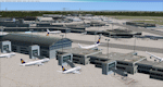
This major update represents EDDF in the December 2012 timeframe.
With the increasing development of the proposed Terminal 3 area now in use as extended apron parking, this update provides operational ramps for G and H gates including ramp parking for both airline and cargo aircraft, helicopter parking at gates H8 and H12, apron night lighting, vehicular traffic etc. In addition this update features a new Gmax custom fuel tank farm along with custom Frankfurt logos, the recently opened A-plus terminal (7 new gates including 4 A380 gates) in October 2012, a new Air Rail Center model and a new set of cargo offices/buildings that have been placed in the South Cargo area as well as the replacement of the standard FSX blast fences with a new Gmax fence model which adds even further realism to this scenery.
Also, a first time feature for this scenery, it now supports GSX (Ground Services for FSX). The G and H aprons have been customized to support GSX functionality with the correct positioning of the ground service vehicles and pushback operations based on scenery topology. The associated airport .ini file is supplied in this package.
Default FSX scenery is required. See readme/help file for more details.
| Filename: | Frankfurt_Main_Airport_EDDF_v7__auto_install.zip |
| License: | Freeware |
| Added: | 23rd December 2012, 22:28:57 |
| Downloads: | 12,700 |
| Author: | Mark Aldridge |
| Size: | 13.43 MB |
| Category: Flight Simulator 2004 - Scenery | |
| Komakuk Beach & Storm Hills DEW sites in Yukon and Northwest Territories, Canada |
|
Images related to this file:
File Description:
These are DEW line sites in northern mainland Canada, to the west of Tuktoyaktuk.
Komakuk Beach CWKB is not included in FS9 and is in the Yukon, only 20 miles from the Alaska border. It is, as the name suggests, close to the sea, and the gravel runway 3,600' by 125' has its western end almost on the beach.
There is no lighting and no signage and the airfield is officially listed as closed, but in fact is used during the annual maintenance and refuelling of the automated NWS (North Warning Station) close by and for any unscheduled servicing. This replaced the previous much older DEW station that was manned year round and had a lot more buildings.
Storm Hills CWSH is in the Northwest Territories, 43 miles south-southwest of Tuktoyaktuk, up on higher land at 810 feet ASL. The NWS (there was no previous DEW station at this site) is serviced by helicopter from Tuktoyaktuk and has a gravel landing pad on the north side of the station. It will show on a gps and it is 5 miles west of the distinctively shaped and large Parsons Lake. This too was not in FS9.
| Filename: | Komakuk_Beach__Storm_Hills_DEW_sites_in_Yukon_and_.zip |
| License: | Freeware, limited distribution |
| Added: | 16th July 2012, 18:56:09 |
| Downloads: | 304 |
| Author: | Roger Wensley |
| Size: | 1.68 MB |
| Category: Flight Simulator 2004 - Scenery | |
| Mackenzie CYZY in British Columbia, Canada |
|
Images related to this file:
File Description:
Mackenzie is around 120 miles west of Peace River and the BC/Alberta border, at the southern end of Williston Lake. The lake is 135 miles long and the population of the town is about 3,500; those figures illustrate typical Canada, a huge area enjoyed by the few. The main occupations relate to timber and mining in some form, plus tourism (in particular winter sports tourism). The airport is 2 miles southwest of the town, with no regular scheduled flights but it is not unusual to find Central Mountain Air there delivering either charter passengers or freight. The single runway is aligned 16-34 and 100 feet wide lit asphalt that is just over 5,000 feet long, with (in 2010 or so) an additional 1,500 feet of gravel. There is PAPI at both ends of the asphalt. The largest operation based at the airfield is a helicopter company, at the northern end of the apron. There is a "mandatory frequency" of 123.5 which is a Canadian invention; you MUST have a radio. There is no control tower at the actual airfield, and if or when there is no response from further afield then you announce your intentions etc. In FS9 there is no way to "switch off or on" the monitoring of a MF radio frequency so you will find that this one is always silent.
| Filename: | Mackenzie_CYZY_in_British_Columbia_Canada.zip |
| License: | Freeware, limited distribution |
| Added: | 27th December 2018, 20:19:05 |
| Downloads: | 131 |
| Author: | Roger Wensley |
| Size: | 19.81 MB |
| Category: Flight Simulator 2004 - Scenery | |
| PASN St Paul Island in Alaska |
|
Images related to this file:
File Description:
This is St Paul Island airport, plus the town and the harbour which has featured alongside Dutch Harbor in the tv series Deadliest Catch.
St Paul is in the Pribilof group of five islands around 250 miles north of Dutch Harbour. The town has a population of less than 600, so a lot smaller than Dutch Harbour and with only one processing plant, Trident.
The Ai includes a PenAir flight, a Coast Guard C-130, and Coast Guard helicopters; sea AI includes a fishing boat and a Coast Guard cutter. The Coast Guard C-130 and helicopter flights are to Dutch Harbor, so both sceneries are required to make it work as it should. The airport has 6,500 feet of 150 feet wide asphalt with 1,000 feet of over-run at each end, aligned 36/18, lit, and with two aprons at the southern end. There is no hangerage except for Coast Guard helicopters. Runway 36 has at its northern end a hill.
In real life the runway slopes up to the north by over 60 feet, but in FS9 it doesn't; hence the change in airport elevation to 80 feet ASL to get the northern end at least partly out of a box canyon. There is fuel available and it is dispensed from a truck, there are no pumps.
| Filename: | PASN_St_Paul_Island_in_Alaska.zip |
| License: | Freeware, limited distribution |
| Added: | 12th August 2012, 17:39:02 |
| Downloads: | 1,100 |
| Author: | Roger Wensley, Sidney Schwartz |
| Size: | 4.06 MB |
| Category: Flight Simulator X - Aircraft Repaints, Textures and Modifications | |
| Dutch Army Pilatus PC-6C H2 |
|
Images related to this file:
File Description:
Pilatus PC-6C H2 Turbo Porter for FSX by Tim Conrad in a fictional Royal Netherlands Army livery. The PC-6C Turbo Porter has been an amazing contribution to the STOL aircraft fleet around the world for decades. It's robust airframe and excellent aerodynamics make the plane very popular for para-drops, but also for supply missions in remote area's throughout the globe. Despite it's age the aircraft is still widely in use. This repaint represents a "what-if" livery for the Royal Netherlands Army (RNLA). In the far past the RNLA could depend on the Beaver and similar aircraft for light support and small batch para-drops (later the Fokker F-27's performed these tasks). Nowadays they are performed by the Dutch "Defence Helicopter Command" (AS-532U2 Cougar's and CH-47D Chinook's) and by the 336 Sqn C-130's. This livery resembles a fictional light utility aircraft registred to the Dutch Army, with corresponding low-visibility (and night-ops optimal) color scematics. The emblem and aircraft name belong to the "Korps Commando Troepen", the Dutch Army Special Forces based at Rosendaal. The name "Achnacarry" denotes the place in Scotland where the Dutch Commando Unit was founded in WWII. You need the excellent freeware PC-6C H2 Turbo Porter by Tim Conrad in order to use this repaint. Enjoy!
| Filename: | Dutch_Army_Pilatus_PC6C_H2.zip |
| License: | Freeware |
| Added: | 7th September 2010, 21:15:56 |
| Downloads: | 424 |
| Author: | Rene Spaan |
| Size: | 6.71 MB |
| Category: Flight Simulator 2004 - Scenery | |
| Nicholson Peninsula CWNP & Liverpool Bay CWLB DEW sites in Northwest Territories, Canada |
|
Images related to this file:
File Description:
These are DEW line sites in northern mainland Canada, to the east of Tuktoyaktuk.
Nicholson Peninsula is 100 miles east of Tuktoyaktuk and was not included in FS9. The peninsula is sometimes more like an island than a peninsula as it is barely connected to the mainland and at times is not connected at all (see the current Gogle Earth!). At the northern end there is another long and narrow gravel bar that is formed by the tide and currents and the gravel runway is on the top of this. It is now officially closed, but is still usable. The annual refuelling and maintenance to the NSW station up on the hills is carried out from a barge that lands tanker trucks onto the shore for the drive up the existing gravel roads that have been there since the early DEW station was established.
Liverpool Bay is 50 miles east of Tuktoyaktuk, up on higher land at around 300 feet ASL. The NWS (there was no previous DEW station at this site) is serviced by helicopter from Tuktoyaktuk or from a barge a mile away on the beach. There is a gravel landing pad on the north side of the station. To answer your question, the three little houses on stilts are actually fuel tanks for the generators, shaped to shed snow.
| Filename: | Nicholson_Peninsula_CWNP__Liverpool_Bay_CWLB_DEW_s.zip |
| License: | Freeware, limited distribution |
| Added: | 17th July 2012, 18:55:24 |
| Downloads: | 236 |
| Author: | Roger Wensley |
| Size: | 1.84 MB |
| Category: Flight Simulator 2004 - Scenery | |
| Haines Junction CYHT in Yukon Territory Canada |
|
Images related to this file:
File Description:
Haines Junction is a village in the Yukon Territory, Canada, amid the Rocky Mountains and around 80 miles west of Whitehorse. It is sited at the junction of the Haines Highway and the Alaska Highway, hence the name. The village was established in 1942 when the Alaska Highway was under construction, and the Haines Highway was built over the Chilkat Pass to connect to the town of Haines on the Alaska coast.
The date of this scenery is, as usual, around 2010. At that time there was a regular service (not always a daily one, depending on the time of year) by Yukon Air North, and in this case it is by an ATR 42-300. There is a helicopter company based at the airfield, Trans North Helicopters, and there is also Kluane Glacier Air Tours, which, as the name suggests, takes you to a glacier so you can stroll around on ice. And then brings you back. The gravel runway is 5,000 feet long and aligned 04-22, and is lit, with PAPI at both ends. Right hand circuits are required for runway 04 as the terrain is not flat.
This post will be followed by two other airfields to the northwest, Silver City and Burwash, both of which are on or close to the Alaska Highway.
| Filename: | Haines_Junction_CYHT_in_Yukon_Territory_Canada.zip |
| License: | Freeware, limited distribution |
| Added: | 22nd January 2022, 21:53:16 |
| Downloads: | 115 |
| Author: | Roger Wensley |
| Size: | 20.46 MB |
| Category: Flight Simulator X - Scenery | |
| 63 AI Ships and AI Ship Traffic for South America and Europe V1 |
|
Images related to this file:
File Description:

Plenty of good designers have created beautiful navy ships and aircraft carriers for FSX, but only few have created container ships, tankers, off-shore supply ships, tugs, or bulk carriers and put them to sail around the globe in FSX. With this package I intend to fill a part of this gap and to bring more life to the mostly empty oceans in FSX by providing AI ships and AI traffic files with a fleet of modern merchant ships travelling through some of the most heavily trafficked sea routes in the world. The pack contains 63 AI ships based on more than 35 different GMAX models. Around one third are equipped with landable helicopter decks. Most ships have simple animations like rotating radars and most have custom light, smoke and wake effects. The pack also contains traffic files for the east coast of South America and the coasts of North West Europe: In South America ships visit Belem, Sao Louis, Natal, Recife, Salvador, Macae, Rio de Janeiro, Santos, Florianopolis, Pelotas, Porto Alegre, Montevideo, Buenos Aires and Puerto Madryn. In Europe ships visit Gibraltar, Algeciras, Lissabon, Bordeaux, La Rochelle, Saint Nazaire, Brest, Le Havre, Antwerp, Rotterdam, Amsterdam, Thamesport, Felixstowe, Bremerhaven, Hamburg, Esbjerg, Oslo, Aarhus, Copenhagen and St.Petersburg. For map of coverage, routes and ship details see the PDF manual.
| Filename: | 63_AI_Ships_and_AI_Ship_Traffic_for_South_America_.zip |
| License: | Freeware |
| Added: | 3rd March 2013, 16:37:41 |
| Downloads: | 23,946 |
| Author: | Henrik Nielsen |
| Size: | 17.24 MB |
© 2001-2026 AVSIM Online
All Rights Reserved
Privacy Policy |