
Where Flight Simulation Enthusiasts Gather from Around the World!
AVSIM Library - Search Results

| Category: Flight Simulator 2004 - AFCAD Files | |
| Dieppe (LFAB) AFCAD & Traffic Files (CoBOY) |

|
File Description:
New AFCAD and Traffic files for LFAB. Adds parking, taxi routes, backtracking for Runway 13 takeoffs, several local flights and TNG flights for the Aero-Club de Dieppe Flying School. All registrations are fictional!
| Filename: | Dieppe_LFAB_AFCAD__Traffic_Files_CoBOY.zip |
| License: | Freeware |
| Added: | 7th May 2006, 14:17:09 |
| Downloads: | 353 |
| Author: | Ron Peckham |
| Size: | 1.23 MB |
| Category: Flight Simulator 2004 - Scenery | |
| Area 51 - Groom Lake Facility FS2004 |
|
File Description:
The mysterious and intriguing Nevada Test
Site airport that is not charted or
included with FS2004.
Made with public domain satellite imagery
and AFCAD. Includes correct runways, even
the combination runway/taxiway 30/12.
| Filename: | Area_51__Groom_Lake_Facility_FS2004.zip |
| License: | Freeware |
| Added: | 29th August 2005, 19:21:45 |
| Downloads: | 3,756 |
| Author: | TJ Synkral |
| Size: | 2.41 MB |
| Category: Prepar3D V1-4 - Scenery | |
| KXWA Williston Basin International Airport (2020) |
|
Images related to this file:
File Description:
A framerate friendly design of Williston Basin International Airport (XWA/KXWA). Modeled on recent OSM data. Includes accurate gate positions, taxiways, designators and signs at runway hold positions. Optimized for use with ORBX packages.
| Filename: | KXWA_Williston_Basin_International_Airport_2020.zip |
| License: | Freeware, limited distribution |
| Added: | 9th January 2021, 23:22:15 |
| Downloads: | 146 |
| Author: | Luc Maaskant |
| Size: | 84.53 KB |
| Category: Flight Simulator 2004 - Scenery | |
| Brasília Airport (SBBR) |
|
File Description:
FS2004 Scenery -- Brasilia Airport (SBBR), Brazil, including the new runway (11R/29L), updated and improved, operational since 2006, January and other fixes on the taxiways and parking areas. Also includes a new control tower.
| Filename: | Braslia_Airport_SBBR.zip |
| License: | Freeware |
| Added: | 1st August 2006, 01:30:30 |
| Downloads: | 5,393 |
| Author: | Luiz Beneduzi |
| Size: | 1.74 MB |
| Category: Flight Simulator X - AFCAD Files | |
| KTIK - Tinker Air Force Base - Oklahoma City, Oklahoma USA v3.0 |
|
Images related to this file:
File Description:
This is an update of my 2.0 release of 2012-01-20. It contains significant infrastructure enhancements, runway renumbering, new signage, new land masks, and provides expanded parking for MAIW's B-52H AI models.
| Filename: | KTIK__Tinker_Air_Force_Base__Oklahoma_City_Oklahom.zip |
| License: | Freeware |
| Added: | 18th January 2014, 07:53:14 |
| Downloads: | 1,526 |
| Author: | Allen Laughmiller |
| Size: | 31.71 KB |
| Category: Flight Simulator 2004 - Scenery | |
| Algiers Real Scenery version 1.01 |
|
Images related to this file:
File Description:
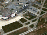
FS2004 Algiers Real Scenery version 1.01 by Riad GHENIM
Algiers DAAG, Algeria, Houari Boumedienne Airport with new parking marks and PAPI for Runway 05.
This scenery needs Algiers City PhotoTerrain scenery available on www.avsim.com
| Filename: | Algiers_Real_Scenery_version_101.zip |
| License: | Freeware |
| Added: | 3rd June 2011, 22:22:18 |
| Downloads: | 12,262 |
| Author: | Riad Ghenim |
| Size: | 19.53 MB |
| Category: Flight Simulator 2004 - Scenery | |
| Joslin-Magic Valley Regl KTWF |
|
File Description:
FS2004 Scenery-Joslin Field - Magic Valley Regl Airport (KTWF) serves Twin Falls, ID and Twin Falls County and is owned by the City & County Of Twin Falls. The airport has more than one runway. The longest is a paved runway extending 8703 feet. The facility is at an elevation of 4151 feet at a distance of about 4 miles from Twin Falls. Created with EZ Scenery, Rwy12 and Lago's FSE with AFCAD2 and Traffic Tools. Textures for custom EZ Scenery objects included. By John B. Loney, Jr.
| Filename: | JoslinMagic_Valley_Regl_KTWF.zip |
| License: | Freeware |
| Added: | 3rd July 2006, 01:48:04 |
| Downloads: | 1,094 |
| Author: | John B. Loney, Jr. |
| Size: | 891.05 KB |
| Category: Miscellaneous Files - General Utilities | |
| Boeing Autobrake Calculator |
|
File Description:
This little console application is intended for Boeing 737, however, it is highly likely the data it uses in this very first release will also work correctly for other Boeing models. The only difference is lack of Autobrake 4 setting. Input data are speed, runway and weather conditions. The program calculates necessary autobrake setting for full stop landing, as well as setting allowing to vacate using desired rapid exit or normal taxiway. Wind speed limitations for 737 and contaminated runway factor are also implemented.
| Filename: | Boeing_Autobrake_Calculator.zip |
| License: | Freeware, limited distribution |
| Added: | 5th July 2007, 16:15:10 |
| Downloads: | 553 |
| Author: | Michal Kwiecinski |
| Size: | 8.55 KB |
| Category: Flight Simulator 2004 - Scenery | |
| Black Pond Airstrip - N46 |
|
Images related to this file:
File Description:
Welcome to Black Pond airstrip. This is an airstrip located in Farmers Mill, NY. It is a privately owned airstrip and it has a very mysterious history. Farmer's Mill is located east of KPOU and on the other side of the Hudson River east from KSWF near the Taconic state parkway. This is the first airport I have ever created. It includes one 3500' tarmac runway, 1000' grass strip, and a 4500' water runway. This was created for FS2004, but it might work with FSX. Happy flying!
| Filename: | Black_Pond_Airstrip__N46.zip |
| License: | Freeware |
| Added: | 11th October 2010, 00:02:03 |
| Downloads: | 273 |
| Author: | Sean Zottarelli |
| Size: | 87.5 KB |
| Category: Flight Simulator 2004 - AFCAD Files | |
| Updated AFCAD for Concord Regional, North Carolina (KJQF) |
|
Images related to this file:
File Description:
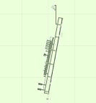
If you are like me, maybe you have broken out of the clouds on an ILS approach to JQF and find that the runway in front of you is almost 2,000 feet shorter than the one on your current airport diagram. This file will take care of that (and then some). Lengthens the runway to 7,400 feet, adds new taxiways and buildings, updates all taxiway signs, and adds the north taxiway/buildings for Ganassi Racing. Uses all generic scenery items--requires no additional files. Enjoy!
| Filename: | Updated_AFCAD_for_Concord_Regional_North_Carolina_.zip |
| License: | Freeware |
| Added: | 1st July 2011, 22:00:21 |
| Downloads: | 289 |
| Author: | Derek Herchko |
| Size: | 7.85 KB |


© 2001-2026 AVSIM Online
All Rights Reserved
Privacy Policy |