
Where Flight Simulation Enthusiasts Gather from Around the World!
AVSIM Library - Search Results

| Category: Civil Flight Simulators - Looking Glass Flight Unlimited 3 | |
| SanFran 2006 |

|
File Description:
SanFran 2006 is a complete upgrade of the San Francisco scenery region, and includes AI modifications to the Unicom and tower controlled airports, a significant upgrade of San Jose International airport, a version of Oakland International airport that has been split into two separate components, hundreds of trees at virtually all of the airports and airfields, five extra real airfields (including a fully operational, tower controlled version of Hamilton AFB), a new version of Byron Municipal airport, six Unicom airports upgraded to tower control (Byron Municipal, Davis Woodland Winters, Half Moon Bay, Nut Tree, Rio Vista, and University), an animated objects package, and lots of interesting objects scattered throughout the region (marinas, parks, ports, bridges, oil terminals, electricity pylons, electrical substations, water towers, radio masts, fire lookout towers, lighthouses, and wind turbines).
| Filename: | SanFran_2006.zip |
| License: | Freeware, limited distribution |
| Added: | 15th November 2005, 19:47:59 |
| Downloads: | 968 |
| Author: | Christopher Low and Jon Point |
| Size: | 5.27 MB |
| Category: Flight Simulator X - Scenery | |
| Descobrir Portugal X |
|
File Description:
This is the first version of DESCOBRIR PORTUGAL for FSX.
My intention is to create a new global scenery for the Portuguese territory, with new coast lines, roads, railroads, landclass, airports and local landmarks, lighthouses, bridges, castels and many other improvements.
In this first attempt for FSX:
Complete Scenery for: LPMU Mogadouro, LPCS Cascais Tires, LPEV Évora, LPPM Portimão.
Incomplete scenery for: LPBR Braga, LPBG Bragança, LPPR Oporto Intl, LPHR Horta; LPCE Cerval.
Realistic afcads for: LPVL Maia, LPVR Vila Real, LPMR Monte Real AB, LPSR Santarem, LPAT Almoster, LPMX Machede, LPLG Lagos, LPTV Tavira, LPAP Armação de Pera, LPPV Praia Verde, LPPI Pico.
150 Kms. Of replaced coastlines.
6200 Kms2 of realistic landcass, roads, Rivers, landmarks, etc.
Any comments and suggestions are wellcome.
ONLY for flight Simulator X.
| Filename: | Descobrir_Portugal_X.zip |
| License: | Freeware |
| Added: | 24th February 2007, 22:52:09 |
| Downloads: | 13,262 |
| Author: | José Maia |
| Size: | 24.29 MB |
| Category: Flight Simulator 2004 - Scenery | |
| FREEflow Bermuda v1.3 |
|
File Description:
FREEflow Bermuda is a FREE scenery addon for Microsoft Flight Simulator: ACOF which will transform the Islands of Bermuda. Features include: Land class scenery which accurately reflects vegetation and population of the Islands of Bermuda. Water class scenery which properly reflects vibrant tropical reefs of Bermuda. Completely new ocean coasts, bays, and ponds accurately placed using Landsat imagery. All new detailed Bermuda International Airport (TXKF) with accurate AFCAD. Accurately placed, custom GMax models for many landmarks in Bermuda, including both lighthouses and many historic buildings. All major roads, highways and bridges. AI surface traffic including a custom designed ferry system with accurate scheduling, and many others. A configuration utility to tailor this scenery to your system and personal preferences. v1.3 adds taxiway signs to TXKF and addresses a number of minor problems.
| Filename: | FREEflow_Bermuda_v13.zip |
| License: | Freeware, limited distribution |
| Added: | 7th October 2005, 18:38:50 |
| Downloads: | 13,345 |
| Author: | FS-FREEflow (Scott Gridley, Joe Watson, Jim Campisi, Ron Jeffers, Bob Brown, Barry Wells) |
| Size: | 19.77 MB |
| Category: Flight Simulator 2004 - Scenery | |
| Central Europe 1961 |
|
Images related to this file:
File Description:

This scenery package contains twelve airports in Germany, nine in the Netherlands, one in Luxembourg, three in Switzerland , and three in Austria - providing taxiways and details as they were at the beginning of the 1960's.
We also created the harbors of Rotterdam, Hamburg and Den Helder, all the lighthouses along the Dutch coast and some along the German coast, and created the island of Helgoland from scratch. Although most of the airports of the package are for civil use, we also produced some Dutch military bases with AI and static aircraft. At many of the airports you will find moving crash tenders and at Amsterdam moving airport buses. Although we did not always have enough photos and information we tried to come as close as possible. Our goal was to reflect something of the atmosphere and feel of that period, prior to the all-jet era of today.
| Filename: | Central_Europe_1961.zip |
| License: | Freeware, limited distribution |
| Added: | 17th May 2013, 20:07:54 |
| Downloads: | 6,637 |
| Author: | Wolfgang Gersch, Harry Biard, Michael Schneider,Jaap de Baare, Nikko Yaginuma, Tom Gibson, Bernard Leuenberger and Mike Stevens |
| Size: | 55.23 MB |
| Category: Flight Simulator 2004 - Scenery | |
| Glacier Bay - Alaska/Canada, Version 2, Part 1 of 2 |
|
Images related to this file:
File Description:
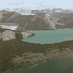
Glacier Bay v2 is a complete replacement of the default FS2004 landscape and scenery of more than 90,000 square kilometers (36,000 sq miles) of Southeast Alaska and adjacent areas of Yukon and British Columbia. File 1 of 2 (also requires glbayv2b.zip)
Landscape enhancements include high-resolution terrain mesh, detailed shorelines, rivers, lakes, and glaciers, and accurate land cover data with custom seasonal ground textures. Inland water bodies can be made to "freeze over" via an on/off switch. Other landmarks include the settlements of Juneau, Haines, Skagway, Yakutat, Atlin, and Carcross as well as road and railroad networks, cabins, lodges, and lighthouses. We modeled or enhanced 16 main airfields (plus one fictitious airstrip), 20 unlisted airstrips, 16 seaplane bases, and seven heliports. We've also included AI ship traffic in various locations as well as optional flightplans for GA and floatplane AI traffic.
Glacier Bay v2 is fully compatible with other third-party add-ons, including terrain mesh (FSGlobal, FS Genesis, etc.), ground textures (Ground Environment, BEV, FScene, etc.), and landscape enhancements (Ultimate Terrain Canada/Alaska, Misty Fjords, Tongass Fjords, Freight Dogs). A configurator panel (requires .Net Framework!) allows users to set compatibility options and to choose levels of scenery detail. We provide an autoinstaller and detailed documentation with a sectional map of the coverage area and a list of weblinks to real-world information.
For feedback and questions, please visit the Glacier Bay v2 support forum at http://forums.fsaddon.eu/viewforum.php?f=10. This project is a collaboration of nine FS developers from Germany, Austria, USA, and Canada, logging more than 1000 hours of work over the past 14 months. We acknowledge the kind support of FSAddon.com. However, this project is independent of any commercial company or product. Enjoy!
| Filename: | Glacier_Bay__AlaskaCanada_Version_2_Part_1_of_2.zip |
| License: | Freeware, limited distribution |
| Added: | 28th May 2010, 19:34:54 |
| Downloads: | 41,280 |
| Author: | Holger Sandmann, Rainer Duda, Michael Eder, Scot Fraser, Manfred Herz, Jay Langham, Jon Patch, Larry Silsbee, and Jim Vile |
| Size: | 56.46 MB |
| Category: Flight Simulator 2004 - Scenery | |
| Glacier Bay - Alaska/Canada, Version 2, Part 2 of 2 |
|
Images related to this file:
File Description:

Glacier Bay v2 is a complete replacement of the default FS2004 landscape and scenery of more than 90,000 square kilometers (36,000 sq miles) of Southeast Alaska and adjacent areas of Yukon and British Columbia. File 2 of 2 (also requires glbayv2a.zip)
Landscape enhancements include high-resolution terrain mesh, detailed shorelines, rivers, lakes, and glaciers, and accurate land cover data with custom seasonal ground textures. Inland water bodies can be made to "freeze over" via an on/off switch. Other landmarks include the settlements of Juneau, Haines, Skagway, Yakutat, Atlin, and Carcross as well as road and railroad networks, cabins, lodges, and lighthouses. We modeled or enhanced 16 main airfields (plus one fictitious airstrip), 20 unlisted airstrips, 16 seaplane bases, and seven heliports. We've also included AI ship traffic in various locations as well as optional flightplans for GA and floatplane AI traffic.
Glacier Bay v2 is fully compatible with other third-party add-ons, including terrain mesh (FSGlobal, FS Genesis, etc.), ground textures (Ground Environment, BEV, FScene, etc.), and landscape enhancements (Ultimate Terrain Canada/Alaska, Misty Fjords, Tongass Fjords, Freight Dogs). A configurator panel (requires .Net Framework!) allows users to set compatibility options and to choose levels of scenery detail. We provide an autoinstaller and detailed documentation with a sectional map of the coverage area and a list of weblinks to real-world information.
For feedback and questions, please visit the Glacier Bay v2 support forum at http://forums.fsaddon.eu/viewforum.php?f=10. This project is a collaboration of nine FS developers from Germany, Austria, USA, and Canada, logging more than 1000 hours of work over the past 14 months. We acknowledge the kind support of FSAddon.com. However, this project is independent of any commercial company or product. Enjoy!
| Filename: | Glacier_Bay__AlaskaCanada_Version_2_Part_2_of_2.zip |
| License: | Freeware, limited distribution |
| Added: | 28th May 2010, 19:36:31 |
| Downloads: | 40,552 |
| Author: | Holger Sandmann, Rainer Duda, Michael Eder, Scot Fraser, Manfred Herz, Jay Langham, Jon Patch, Larry Silsbee, and Jim Vile |
| Size: | 85.99 MB |
| Category: Flight Simulator 2004 - Scenery | |
| Ría de Vigo (Bay of Vigo) |
|
File Description:
Comprehensive revision of the area surroinding the Bay of Vigo, near the Vigo Airport (LEVX, aprox. at 42º18'N 8º38'W), in Galicia, Spain, including a more accurate coastline, from the Ría de Aldán until Toralla Island, plus the San Simon Island and other minor islands, detailed piers in Vigo and Cangas, several beaches, and a lot of 3D VFR references (more than 180 macros added), such as buildings (the City Hall, the Hospital Xeral, the Balaídos Stadium, the Castro stronghold...), working lighthouses, several monuments and statues, some main streets redrawn, a new version of my Rande Bridge, now with collision detection and landable surface, and a handfull of eye-candies I can't even remember! -
Completa revisión da costa da Ría de Vigo, dende a Ría de Aldán ata pasada a Illa de Toralla, incluíndo, por suposto, á Illa de San Simón e outros pequenos illotes, praias (Samil, Nerga...), os peiraos de Cangas e de Vigo, dende o Areal ata Bouzas, unha morea de novas referencias visuais (máis de 180 macros), con edificios (o Concello, o Hospital Xeral, o estadio de Balaídos, o castelo do Castro, o lazareto de San Simón...), faros (nas Cíes e na costa...), algún que outro monumento, unha revisión do trazado dalgunhas das vías principais, unha nova versión da miña Ponte de Rande, con detección de colisións e superficie "aterrable", e moitas cousas máis que xa nin eu mesmo lembro. -
Completa revisión de la costa de la Ría de Vigo (Galicia, España, aprox. en 42º18'N 8º38'O), desde la Ría de Aldán hasta pasada la Isla de Toralla, incluyendo la Isla de San Simón y otros pequeños islotes, playas (Samil, Nerga...), los muelles de Cangas y de Vigo, desde el Areal hasta Bouzas, un montón de nuevas referencias visuales (más de 180 macros), con edificios (el Ayuntamiento, el Hospital Xeral, el estadio de Balaídos, el castillo del Castro, el lazareto de San Simón...), faros (en las Cíes y en la costa...), algún que otro monumento, una revisión del trazado de algunas de las vías principales, una nueva versión de mi Puente de Rande, con detección de colisiones y superficie "aterrizable", y muchas cosas más de las que ni yo mismo me acuerdo.
| Filename: | Ra_de_Vigo_Bay_of_Vigo.zip |
| License: | Freeware |
| Added: | 16th May 2004, 23:48:38 |
| Downloads: | 4,478 |
| Author: | Rubén Castiñeiras |
| Size: | 366.85 KB |
© 2001-2026 AVSIM Online
All Rights Reserved
Privacy Policy |