
Where Flight Simulation Enthusiasts Gather from Around the World!
AVSIM Library - Search Results

| Category: X-Plane - Scenery | |
| WPDL Dili International Airport v1.0.0 |

|
Images related to this file:
File Description:

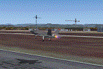
This is an X-Plane 11 scenery for Presidente Nicolau Lobato International Airport (WPDL/DIL) in Dili, East Timor (Timor Leste). This airport may serve as a stopover for flights between Java and Papua, for the Susi Air scenery package. Susi Air is pictured in the 2014 TV mini-series "Worst Place to be a Pilot", that follows the highs and lows in the lives of the young British pilots who work for Susi Air, as they fly and land their planes in some of the most breath-taking, remote and dangerous locations on earth. For more info, search for "Worst Place to be a Pilot" in YouTube. This scenery was tested and is operational (as of January 16, 2017) in "X-Plane 11 Public Beta #6 64 bit", Windows 10 Home. It was also tested and is operational (as of January 16, 2017) in "X-Plane 10.51 Public Beta #3 64 bit", Windows 10 Home. In XP10, you may have a scenery error message saying the sceney may not look correct. This is due to one file used from XP11 native library. If you see this message, just ignore it, bypassing it by clicking "understood". The scenery will load and will be operational in XP10 users (as a courtesy), despite being created natively for XP11 users.
| Filename: | WPDL_Dili_International_Airport_v100.zip |
| License: | Freeware |
| Added: | 17th January 2017, 02:52:15 |
| Downloads: | 110 |
| Author: | Rui Mesquita |
| Size: | 4.38 MB |
| Category: Flight Simulator 2004 - Scenery | |
| Peace River CYPE in northwest Alberta, Canada UPDATED |
|
Images related to this file:
File Description:
This is an updated version of the original post (from 2014) made in November 2018. It provides missing textures, and deals properly with an ai problem that I thought I had already fixed. It also adds extra objects to the apron area and adds a third gate. It is complete in itself and can be installed as-is if you do not have the original post. The Peace River flows east from the Rockies, joining up with the Slave River to empty into Great Slave Lake. The town is on both banks close to a bend where the Peace turns to the north, 245 miles northwest of Edmonton. The population is 7,000 and the surrounding area is either farmland or forest. The airport is just over 3 miles west of the town. The runway is 5,000 feet of wide asphalt (150 feet) aligned 04/22, lit, and with PAPI. There is a second runway to the south of the main runway, 1,900 feet of grass and aligned 08/26. The apron is to the north of the runway at the eastern end and is large; there is a purpose-built terminal building, plus other hangar buildings along taxiway C that extends westward from the apron. The airport is experiencing an increase in scheduled and GA flights in the last few years.
| Filename: | Peace_River_CYPE_in_northwest_Alberta_Canada_UPDAT.zip |
| License: | Freeware, limited distribution |
| Added: | 10th December 2018, 17:33:25 |
| Downloads: | 127 |
| Author: | Roger Wensley |
| Size: | 24.27 MB |
| Category: Flight Simulator X - Aircraft Repaints, Textures and Modifications | |
| FSX/P3D Ethiopian Airlines 707-379C 1968 |
|
Images related to this file:
File Description:
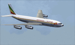
This is a repaint of the 707-379C in Ethiopian Airlines colors. The payware 707-300C by Captain Sim is needed for this repaint. Ethiopian Airlines was established in 1946 by the Emperor Haile Sellassie, and TWA which provided technical and managerial support. Regular operations commenced on April 8 1946 with a fleet of 6 ex USAAF DC-3s. Later in 1950, 2 Convair CV-240s entered the fleet. Then in 1958, the first DC-6B arrived on the scene. On January 1 1959 Ethiopian officially became a member of IATA. The first jet services started in 1963 after the delivery of the carrier's first Boeing 720s. The 720s replaced the DC-6Bs on the European routes. In 1964, Ethiopian started a new pilot training school, installed a large IBM computer system, and also established the largest jet overhaul facility in Africa. 707s, 727s, and 737s, joined the fleet in the ensuing years. Today Ethiopian ranks as Africa's supreme air carrier with a safe and reliable service, notwithstanding the 737 Max 8 tragedy, and has a vast route network. The cherry on top was when in 2014, Ethiopian dethroned South African Airways as the "Best African Airline". Textures are 32 bit dds and DXT5 textures are included as well. This repaint was tested FSX-SE. It should work on FSX & P3Dv1-3.
| Filename: | FSXP3D_Ethiopian_Airlines_707379C_1968.zip |
| License: | Freeware |
| Added: | 20th September 2019, 16:33:20 |
| Downloads: | 131 |
| Author: | Ted Giana |
| Size: | 20.14 MB |
| Category: Prepar3D V1-4 - Scenery | |
| TNCC - Curaçao International Airport |
|
File Description:
This is my first scenary, any problem or sugestion send-me an e-mail ([email protected]). The scenery was made using the Airport Design Editor, SketchUp 2017 an others.
Curaçao International Airport (IATA: CUR, ICAO: TNCC), (Dutch: Hato Internationale luchthaven) also known as Hato International Airport (formerly Dr. Albert Plesman International Airport), is the only airport for the island of Curaçao.
The airport is located on the north coast of Curaçao, 12 kilometres (7.5 mi) from the capital Willemstad. Curaçao International Airport services flights from the Caribbean region, South America, North America and Europe and has the third longest commercial runway in the Caribbean region after Rafael Hernández Airport in Puerto Rico and Pointe-à -Pitre International Airport in Guadeloupe.
The airport serves as a main base for Divi Divi Air, Jetair Caribbean as well as EZAir; it formerly served as a main base for ALM, KLM, DCA, DAE and Insel Air.
Located on the Dutch Caribbean island of Curaçao, connects Europe, the Americas and the Caribbean. Curaçao International Airport is served by several airlines.
The Curaçao International Airport has one of the longest runways in the Caribbean, accommodating up to a Boeing 747. In the early fall of 2014, Curaçao International Airport opened a new General Aviation Center offering premier service in a separate building with a private entrance and exit and special amenities.
| Filename: | TNCC__Curaao_International_Airport.zip |
| License: | Freeware |
| Added: | 8th March 2021, 19:00:36 |
| Downloads: | 552 |
| Author: | Eduardo Puelker |
| Size: | 7.24 MB |
| Category: Flight Simulator X - Utilities | |
| Flight Simulator First Officer V2.2 |
|
Images related to this file:
File Description:
Flight Simulator First Officer is a generic virtual copilot for FSX and FS9. The primary function of FSFO is to assist the Pilot In Command (PIC) to fly the aircraft safely while adhering to Standard Operating Procedures (SOPs). This is accomplished via virtual checklist and sharing of cockpit duties/responsibilities. Specifically, the First Officer reads the following configurable checklist: Before Start, After Start, Before Takeoff, In-Range, After Landing and Shutdown. After reading the checklist items, the Copilot will wait to ensure you (i.e. the pilot) have configured the aircraft correctly before proceeding to the next item. Also, the Virtual copilot is capable of performing the following actions: Call Vspeeds based on your input, Raise the Landing Gear on Takeoff, Retract the Flaps, Manage the taxi/landing lights, Land the Aircraft, Tune the ILS frequencies, Call Climb Power based on your input, Reset Vertical Speed when the Aircraft is within 1000 ft of the programmed altitude, IAS warning (e.g. Aircraft is above 250 IAS while below 10000 ft), GS Warnings (e.g. Aircraft is above 25 knots while taxing), Resets the altimeter to standards when passing TA, Engage Heading Hold on Takeoff, Engage Altitude Hold on Takeoff, Reset Speed on Takeoff, Engage Speed Hold on Takeoff, Engages Rev Thrust on Landing, Ground Proximity Warning System (GPWS) and much more...
View the change log to view what's new with V2.2: http://flightsimaddons.proboards.com/thread/32/change-log-updated-july-2014
This is a complete installer; you DO NOT need FSFO V2.*. If upgrading from 2.*, please read the attached readme.txt file for instructions
| Filename: | Flight_Simulator_First_Officer_V22.zip |
| License: | Freeware, limited distribution |
| Added: | 12th July 2014, 08:19:29 |
| Downloads: | 2,356 |
| Author: | Matthew King |
| Size: | 67.17 MB |
| Category: Flight Simulator 2004 - Aircraft Repaints, Textures and Modifications | |
| World Fish & Agriculture Inc. "Winkys Fish" Lockheed R7V-1 / C-121J |
|
Images related to this file:
File Description:
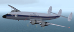
Textures for Lockheed R7V-1/C-121J by Team 1049 - Roland Berger, Volker Boehme, Manfred Jahn, Luis Pallas, Bill Tyne and Stefan Werner. Repainted by Manfred Meyer.
A working installation of the G and H Super Constellation packs (L1049H.ZIP, L1049GZIP and r7v-1.ZIP)is required, use the 1049vc_rf model for this textures!
This aircraft was built 1953 as a R7V-1 BuNo 131643 for US Navy (c/n 4144) and 1960 redesignated as C-121J. Serving whis the Point Mugu Missile Range it was known as the "Ole Blue from Point Mugu". 1974 withdrawn from use and stored at Davis Monthan, she was sold in May 1981 to William "Winky" Crawfords Northern Peninsula Fisheries Corp. and reg. N4247K for hauling salmon in Alaska. After modification work to civil freighter in 1987 the Connie went to World Fish & Agriculture Inc. Cold Bay Alaska, another Crawford Company. Now it was the plan to hauling thunafish from Palau Island to Nagoya in Japan. It was intend to carry 38 000 lbs of fish per trip but only 33 000 lbs were practial. But the contract could not be fullfiled because no high grade AVGAS was available at Nagoya. The aircraft has to carry return fuel in drums, which reduced the payload further to only 15 000 lbs.
Only a few roundtrips were flown in 1988 and then the Connie was impounted and stored at Manila apt. due to lawsuit actions with the contractors. She remains abandonded in open storage at Manila until 2014 as the Quantas Museum from Australia bought her in auction for spares.
| Filename: | World_Fish__Agriculture_Inc_Winkys_Fish_Lockheed_R.zip |
| License: | Freeware |
| Added: | 17th November 2014, 22:44:15 |
| Downloads: | 155 |
| Author: | Manfred Meyer |
| Size: | 5.62 MB |
| Category: Flight Simulator 2004 - Scenery | |
| Grande Prairie CYQU in Alberta, Canada, Updated |
|
Images related to this file:
File Description:
This is a new version of the original post from March 2014, made in 2018. It was made mainly to provide some missing textures, but has been modified to also add parked trucks and floodlights to the de-icing area (the floodlights are inoperative as they will not be on when there is no de-icing in progress) and also street and car parking lighting, a few more parked planes, and some further objects on the terminal apron area. The runway approach lighting was also corrected; moving the airport so that the ILS on 29 did not coincide with the roads would have been nice, but meant too many complications at this stage. The scenery is complete in itself and can be installed as-is if you do not have the original post. Grande Prairie is at 2,195 feet asl, 65 miles southeast of Dawsons Creek, 90 miles southwest of Peace River and around 60 miles east of the Rockies. The town has a population of around 55,000 and growing. The name comes from the wide expanse of prairies all around the town, and there is also a large forested area to the southwest leading up to the Rockies which supplies raw material for industries in the town. The airport is just to the west of the town. It was originally a military base, built during WW2. The two runways are 07-25 and 11-29 and 6,200 and 6,500 feet respectively, both 200 feet wide; runway headings had changed by 2010 in real life but take this as it was in 2008. When one is the active runway then the other is used as a taxiway. Taxiway A is very wide with in real life a repaired central section marked out for use.
| Filename: | Grande_Prairie_CYQU_in_Alberta_Canada_Updated.zip |
| License: | Freeware, limited distribution |
| Added: | 13th December 2018, 04:12:11 |
| Downloads: | 207 |
| Author: | Roger Wensley |
| Size: | 34.97 MB |
| Category: Flight Simulator 2004 - Aircraft Repaints, Textures and Modifications | |
| Italian Air Force "S.M.Luigi Gorrini" AerMacchi C.205 VELTRO (Greyhound) |
|
Images related to this file:
File Description:
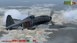
Regarded as the best Italian aircraft of World War II together with the Fiat G-55 Centauro,the Macchi-Castoldi C.205 proved to be extremely effective in action, destroying a large number of Allied bombers and capable of successfully clashing on equal terms with such renowned fighters as the North American P-51D Mustang.Although the C.205 was able to match the best Allied opponents both in speed and maneuverability,it was introduced late during the conflict.Moreover,due to the poor Italian industrial capability of the time,only a small production run was delivered to combat units before the end of the war.Famous C.205 pilots are Italy's highest scoring ace Adriano Visconti and the top scoring C.205 Sergente Maggiore pilota (Sargeant Major pilot) Luigi Gorrini.To date,there's still debate about
Gorrini's score,since Regia Aeronautica preferred crediting units over individual combat achievements.
Gorrini's official aerial combat score is 19 victories,but,according to his memories,he achieved 7 more during his service with Aeronautica Nazionale Repubblicana (A.N.R.), flying a Macchi C.205. These victories did not enter his officiall tally due to political reasons,since the A.N.R. fought by the side of the German Luftwaffe after the Italian September 8th,1943 armistice.These bring his total tally to 26 victories,making him the top scoring Italian fighter ace of WWII.For his combat record with the A.N.R he was awarded twice by the Luftwaffe with the Iron Cross First and Second Class.Luigi Gorrini was also awarded for his actions,after the end of the war,with the highest Italian military decoration,the "Medaglia d'Oro al Valor Militare" (M.O.V.M.,Gold Medal for Military Valour).Last surviving Italian fighter pilot of WWII,he died recently at the age of 97 and this repaint is dedicated to his memory.
Repaint by Manuele Villa/MVG3D, November 2014.
Requires the previous installation of the base Aermacchi C.205 Veltro package by Manuele Villa (C205_V01.zip).
| Filename: | Italian_Air_Force_SMLuigi_Gorrini_AerMacchi_C205_V.zip |
| License: | Freeware |
| Added: | 25th November 2014, 08:39:29 |
| Downloads: | 128 |
| Author: | Manuele Villa |
| Size: | 4.31 MB |
| Category: X-Plane - Scenery | |
| Susi Air Sceney Package Indonesia East Timor v1.0.0 |
|
Images related to this file:
File Description:

This is an X-Plane 11 scenery package in Indonesia and East Timor, 30 airfields in total, all of them are destinations for "PT ASI Pujiastuti Aviation", operating as Susi Air, an Indonesia airlines established in late 2004 by Mrs. Susi Pudjiastuti. Ideal for bush flight lovers, who like to have new challenges outside of the box. Susi Air is pictured in the 2014 TV mini-series "Worst Place to be a Pilot", that follows the highs and lows in the lives of the young British pilots who work for Susi Air, as they fly and land their planes in some of the most breath-taking, remote and dangerous locations on earth. For more info, search for "Worst Place to be a Pilot" in YouTube. This scenery package was tested and is operational (as of January 21, 2017) in "X-Plane 11 Public Beta #8 64 bit", Windows 10 Home. It is meant, primarilly, for XP11 use. However, it was also tested and is partially operational (as of January 21, 2017) in "X-Plane 10.51 64 bit", Windows 10 Home. Most of them will work 100% well in XP10, but a few of them will present mesh issues, once XP11 mesh is improved before the old XP10 mesh files.
List of airfields:
- WA0B Susi Air Idedua Airstrip
- WABI Susi Air Nabire
- WABP Susie Air Timika
- WABX Susi Air Bilai Airstrip
- WAJD Susi Air Wakde Airstrip
- WAJJ Susi Air Jayapura
- WAJW Susi Air Wamena Airport
- WICN Susi Air Headquarters
- WIHH Susi Air Jakarta
- WIPB Susi Int'l Pangandaran Beach Airstrip
- WPDL Dili International Airport
- WT17 Susi Air Siriwo Airstrip
- WT66 Susie Air Wewak Airstrip
- WT75 Susi Air Yogosem Airstrip
- WW01 Susi Air Makki Airstrip
- WW32 Susi Air Nevere
- WW56 Susi Air Pass Valley Airstrip
- WW68 Susi Air Pogapa Airstrip
- WX15 Susi Air Apowo Airstrip
- WX37 Susi Air Beoga Airstrip
- WXAR Susi Air Armopa Road Airstrip
- WXPJ Susi Air Puncak Jaya Mining Airstrip
- WXPN Susi Air Pulau Nurseen Airstrip
- WXRA Mount Rinjani Airstrip Lombok Island Indonesia
- WXTA Mount Tambora Airstrip Sumbawa Island
- WXTC Susi Air Teluk Cendrawasih Beach Airstrip
- WXZ5 Susi Air Kapeso Airstrip
- WXZ8 Susie Air Tsinga Mulu
- WZ31 Susi Air Kasonaweja Airstrip
- WZ38 Susi Air Kegata Airstrip
| Filename: | Susi_Air_Sceney_Package_Indonesia_East_Timor_v100.zip |
| License: | Freeware |
| Added: | 21st January 2017, 19:12:17 |
| Downloads: | 196 |
| Author: | Rui Mesquita |
| Size: | 6.98 MB |
| Category: Flight Simulator 2004 - Scenery | |
| Cameri and Turbigo sceneries (rev. 3) - north Italy |
|
Images related to this file:
File Description:
The following files are required by this file:
http://library.avsim.net/esearch.php?DLID=163723&UploadID=&Name=&FileName=&Author=&CatID=root
http://library.avsim.net/esearch.php?DLID=186350&UploadID=&Name=&FileName=&Author=&CatID=root
This scenery includes a global review of the previous Sceneries of Cameri Military airport (rev.2 Oct 2011), Cameri Museum (rev. 2 Oct 2011), Cameri Babini (rev. 2 oct 2011), Turbigo power station (rev. 2 Sep 2011 and update rev. 2.1 Oct 2014). All the above ARE NOW INCLUDED in this new unique scenery. Contents: Terrain in new version photo-realistic multi-seasons/night; adapted to Western Europe special elevation meshes; cover area of over 120 sqkm from Bellinzago-Oleggio (NW) to Magnago-Bienate (NE), from Novara (SW) to Cuggiono-Inveruno (SE); all the terrain has been restorated with 3D buildings, either through autogen that with specific dedicated objects (by GMax) and with significant addition of library objects ("dva51" and other existings). This scenery (located on the final approach to the Milan Malpensa international airport) includes the Cameri's Mil Airport with the Babini closed Army area and the planes of the Historical Museum of the airport; it is also included the thermoelectric power station of Turbigo. All the buildings are placed to recreate cities and villages covered in the photo-realistic terrain, including Bellinzago, Bienate, Buscate, Caltignaga, Cameri, Castano Primo, Castelletto Ticino, Cuggiono, Galliate, Inveruno, Magnago, Malvaglio, Nibbia, Novara, Oleggio, Pernate, Robecchetto, Romentino, Sant'Anna, San Pietro Mosezzo, Turbigo , Vanzaghello, and the covered Turin-Milan highway.
Details of the new buildings for the care and maintenance to F35 completely recreated, as obtainable from the current satellite view.
It REQUIRES the use of the following, to be downloaded separately :
- the libraries dva51 - the system of vegetations TreePlanter - the West Europe Meshes of Daniele Lanfranchi. See the Readme file. Enjoy!
Videos available here:
https://dl.dropboxusercontent.com/u/38829151/FS9/Cameri_Turbigo_v3%20shots.WMV
http://youtu.be/yVI2KeJKS5o
http://youtu.be/oKa0e_5kxIk
| Filename: | Cameri_and_Turbigo_sceneries_rev_3__north_Italy.zip |
| License: | Freeware |
| Added: | 21st January 2015, 21:32:36 |
| Downloads: | 991 |
| Author: | Aldo Della Vedova, Daniele Lanfranchi and Gian Mario Verga |
| Size: | 103.7 MB |
© 2001-2026 AVSIM Online
All Rights Reserved
Privacy Policy |