
Where Flight Simulation Enthusiasts Gather from Around the World!
AVSIM Library - Search Results

| Category: Flight Simulator 2002 - Original Aircraft | |
| Douglas DC-3 Val-U-Prop CargoLiner Plane and Panel |

|
File Description:
Val-U-Prop is a rogue airline based in Bloomington, Indiana, that flies everything from VIPs to sheep manure anyplace and anytime. VP's motto is "No job too small; No fee too large," and our DC-3's, DC-4's, DC-6's and DC-8's can be seen hedge-hopping into various obscure airports throughout the world. This aircraft is an all-aluminum re-paint of the fabulous DC-3 OH-LCH by Jan Visser, Erik Ellis, Roy Chaffin, Ian Roper and Bill Rambow, to which FS2002 lights have been added. It has military capability, including machine guns and NUCLEAR/GPS/JDAM guided bomb launch. Panel includes everything on main panel, except for GPS and (optional) default radios, so there is no tabbing. The very aluminal wing views were shot by Thomas Klein, and the vintage C-47 cabin was photographed by Tom Turner. Gauges by James Underwood, Ernie Kennedy and Dai Griffiths. A-bomb and machine guns by Chris Trotter. All of this brought to you by Val-U-Prop - http://home.bluemarble.net/~jcumus/index.html - where WE VAL-U-YOU!
| Filename: | Douglas_DC3_ValUProp_CargoLiner_Plane_and_Panel.zip |
| License: | Freeware, limited distribution |
| Added: | 11th March 2003, 02:19:37 |
| Downloads: | 2,594 |
| Author: | James Underwood |
| Size: | 6.64 MB |
| Category: Flight Simulator 2004 - Scenery | |
| MRE Mara Serena, Kenya |
|
File Description:
Googly scenery for Mara Serena, Kenya, a small airfield serving the Mara Serena
Safari Lodge in the Masai Mara National park. The original metalled runway has
fallen into disuse and these days a rough dirt runway alongside it is used by
the twice daily flights of Air Kenya Express to and from Nairobi and the
occasional light aircraft.
Flight Simulator 2004 has made no provision for traffic with only a runway
provided and this scenery seeks to redress the situation. The airport has no
ICAO code (MRE is the IATA code) but Microsoft Flight Simulator has created an
unofficial ICAO of HK0A.
The scenery does not purport to be ultra-accurate. Based on high quality
satellite imagery from Google Earth, the layout is proportionally correct but the
added airport features, such as buildings, are built from default Microsoft objects
and add-on libraries so will not look exactly like the real thing.
You are not obliged to download and install any additional scenery libraries,
but to enjoy this scenery in its entirety, you may wish to. It will work fine,
with or without.
| Filename: | MRE_Mara_Serena_Kenya.zip |
| License: | Freeware |
| Added: | 16th April 2008, 19:19:33 |
| Downloads: | 988 |
| Author: | John Hinson |
| Size: | 68.01 KB |
| Category: Flight Simulator 2004 - Scenery | |
| YEVD Evans Head Memorial, Australia |
|
File Description:
Googly scenery for YEVD Evans Head Memorial, a former RAAF Training base in
New South Wales, Australia, now reduced to a single runway and small apron.
In its heyday it was home to the RAAF No 1 Bombing and Gunnery and the RAAF No 1
Air Observers Schools and it was said to be the largest training base in the
southern hemisphere - at that time it had four runways.
Flight Simulator 2004 has made no provision for traffic with only a runway
provided and this scenery seeks to redress the situation so that you and your
"AI" traffic can use the airport.
The scenery does not purport to be ultra-accurate. Based on high quality
satellite imagery from Google Earth, the layout is proportionally correct but the
added airport features, such as buildings, are built from default Microsoft objects
and add-on libraries so will not look exactly like the real thing.
You are not obliged to download and install any additional scenery libraries,
but to enjoy this scenery in its entirety, you may wish to. It will work fine,
with or without.
| Filename: | YEVD_Evans_Head_Memorial_Australia.zip |
| License: | Freeware |
| Added: | 19th April 2008, 10:23:02 |
| Downloads: | 544 |
| Author: | John Hinson |
| Size: | 71.78 KB |
| Category: Flight Simulator 2004 - Scenery | |
| Cape Dorset CYTE, Baffin Island, Nunavut, Canada |
|
Images related to this file:
File Description:
Cape Dorset is a village of 1,300 or so inhabitants at N 64 13 W 76 31 on Dorset Island, off the southwest corner of Baffin Island. It's Inuit name is Kinngait, which means "High Mountains"; watch out if you fly there in low clouds. The village (again) does not feature in FS9 but is included in this scenery with approximately the right shape, or shapes as there are separate parts. The airfield runway is just under 4,000 feet of gravel 100 feet wide at 158 feet above sea level. There is a double gradient to it, but unfortunately this cannot be replicated in FS.
Cape Dorset had a Hudson Bay Company store as long ago as 1913, and is now known as a centre for Inuit art. I added the roads, a new airfield background, a pond between apron and runway, plus of course there is the scenery file and the AFCAD and AI, which has two planes visiting, a First Air HS748 and a Canadian North Dash 8-100, as per real life.
| Filename: | Cape_Dorset_CYTE_Baffin_Island_Nunavut_Canada.zip |
| License: | Freeware, limited distribution |
| Added: | 9th December 2010, 18:45:06 |
| Downloads: | 1,014 |
| Author: | Roger Wensley |
| Size: | 2.75 MB |
| Category: Flight Simulator X - Scenery | |
| Barbados Island Scenery V2 |
|
File Description:
UPDATED 01/05/2017
Photoscenery for Barbados island for FSX/P3D
Thank you for downloading my first scenery.
I've decided to make my first scenery of my home island Barbados, am very proud of my work and I hope you enjoy it.
UPDATE:
Fixed the Blendmask
Fixed the watermask
added rivers, port and more to the watermask
Barbados is a sovereign island country in the Lesser Antilles, in the Americas. It is 34 kilometres (21 miles) in length and up to 23 km (14 mi) in width,
covering an area of 432 km2 (167 sq mi). It is situated in the western area of the North Atlantic and 100 km (62 mi) east of the Windward Islands and the Caribbean Sea;[6] therein,
it is about 168 km (104 mi) east of the islands of Saint Vincent and the Grenadines and 400 km (250 mi) north-east of Trinidad and Tobago. Barbados is outside of the principal Atlantic hurricane belt.
Its capital is Bridgetown. Barbados is 1,600 mi (2,600 km) Southeast of Miami.
| Filename: | Barbados_Island_Scenery_V2.zip |
| License: | Freeware |
| Added: | 6th January 2017, 08:36:45 |
| Downloads: | 1,789 |
| Author: | Shakur Jones |
| Size: | 80.48 MB |
| Category: Flight Simulator X - AFCAD Files | |
| LGRX - Araxos Airforce Base, Greece |
|
File Description:
LGRX - Araxos AB is a large Hellenic Airforce base located near Araxos Cape, Achaea Prefecture and serves the city of Patras as well as the western part of the Peloponese region. It is the home of the 116 Combat Wing. It is used by a few civilian airlines, mainly for the tourist industry.
The stock airport shows three runways in use, however in reality only one runway is currently used the centre runway is now the main taxiway.
I have added the civilian apron and terminal buildings and various buildings and hangers throughout the base, all are Generic Buildings. Parking for Military and Civilian use, a cargo ramp and lots of trees. As usual I used the fantastic ADE (Airport Design Editor) to design this airport but you should download the great lights package by Jim Dhaenens as I have used some of his Apron Lights. I have provided ILS in one version for simmers who like to fly with it, although there is no ILS at Araxos.
| Filename: | LGRX__Araxos_Airforce_Base_Greece.zip |
| License: | Freeware |
| Added: | 1st July 2013, 18:04:18 |
| Downloads: | 620 |
| Author: | Mike Major |
| Size: | 31.04 KB |
| Category: Prepar3D V1-4 - Scenery | |
| SEATTLE X DEMO - the City and the Airports |
|
Images related to this file:
File Description:

SEATTLE X DEMO features an extremely detailed scenery of large area of Seattle, USA, fully compatible with FSX, FSX SE, P3D v1/v2/v3/v4 and FSW by Dovetail.
With Seattle X you are free to fly to any of 5 airports: KSEA Tacoma, KPAE Paine Field, KBFI Boeing Field, KRNT Renton, S50 Auburn, admire some of the world-renowned landmarks, bridges, harbours, heliports, seaplane bases, ships, etc.
This Demo version features both - the City and the Airports packages (commercial poducts) and includes some downtown buildings as well as all airports with terminals but with low resolution textures, non-animated jetways and generally much less details. This ensures no problems with online (VATSIM, IVAO and multiplayer) flying in case some users have the payware scenery and some don't.
It's equipped with an automatic installer, which means that the scenery will be automatically added to the Flight Simulator Scenery Library.
Please uninstall all previous versions of the above-mentioned airports you may have installed before. Please make also sure that no duplicated AFCAD files are installed.
Enjoy your virtual flying with Drzewiecki Design!
| Filename: | SEATTLE_X_DEMO__the_City_and_the_Airports.zip |
| License: | Freeware, limited distribution |
| Added: | 1st May 2018, 15:50:13 |
| Downloads: | 942 |
| Author: | Drzewiecki Design |
| Size: | 90.12 MB |
| Category: Prepar3D V1-4 - Scenery | |
| EPKK KRAKOW BALICE X V2 DEMO |
|
Images related to this file:
File Description:
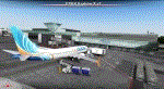
EPKK KRAKOW BALICE X V2 DEMO features the scenery of EPKK Krakow Balice airport and Krakow City, Poland, fully compatible with FSX, FSX:SE, FSW, P3Dv1-v4.
It's a fully functional DEMO version of the commercial payware product. It features same airport layout as in the full version but with limited 3D objects and low resolution textures. Using this free demo ensures no problems with online (VATSIM, IVAO, multiplayer etc.) flying in case some users use the payware scenery and some don't.
John Paul II International Airport Krakow-Balice (KRK / EPKK) is an international airport located near Krakow, in the village of Balice, 11 km (6.8 mi) west of the city centre, in southern Poland. The airport has one concrete runway, number 07/25, 2550x60m.
It's equipped with an automatic installer, which means that the scenery will be automatically added to the Flight Simulator Scenery Library.
Please uninstall all previous versions of this airport you may have installed before. Please make also sure that no duplicated AFCAD files are installed.
Enjoy your virtual flying with Drzewiecki Design!
| Filename: | EPKK_KRAKOW_BALICE_X_V2_DEMO.zip |
| License: | Freeware, limited distribution |
| Added: | 22nd November 2018, 00:56:01 |
| Downloads: | 521 |
| Author: | Drzewiecki Design |
| Size: | 12.67 MB |
| Category: Flight Simulator 2004 - AI Aircraft | |
| Kuwaiti Air Force A-4KU Skyhawk |
|
Images related to this file:
File Description:
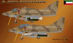
Kuwaiti Air Force A-4KU Skyhawk; for retro AI traffic. This package represents the original delivery batch of Skyhawks to Kuwait which served through the 1980s, until severely reduced during the Iraqi invasion of Kuwait in 1990. This package uses the Nick Black base model set, but these models have been heavily modified by me from the FSDS source. I have added a lot of new things to create two virtually new base models, please refer to the enclosed readme file for a list of adds and changes. All models retain Nick's original XML animations, plus some new ones I created. The aircraft also uses the unaltered (save for one light position change), original FDE by Mike MacIntyre. This package has two main aircraft models, the A-4KU and TA-4KU; and includes 36 serials with many loadout options. The included readme file includes instructions, notes, disclaimers, credits, and anything else I can think of. Original aircraft and source by Nick Black, FDE by Mike MacIntyre, expert mentoring by Frank Safranek and Steve Holland, model modifications and repaints by Michael Pearson.
| Filename: | Kuwaiti_Air_Force_A4KU_Skyhawk.zip |
| License: | Freeware |
| Added: | 25th August 2011, 00:46:16 |
| Downloads: | 362 |
| Author: | Michael Pearson |
| Size: | 12.87 MB |
| Category: Flight Simulator 2004 - Scenery | |
| OPDB Dalbandin, Pakistan |
|
Images related to this file:
File Description:

Googly scenery for OPDB Dalbandin, Pakistan - a quiet domestic airport for
which no operational facilities are provided in Flight Simulator 2004. These
scenery files add/correct the runways, apron, taxiways, buildings and other
airport features so that you and your "AI" traffic can land, taxi, park
and take off in a realistic manner.
The airport appears to be served all of once per week by ATRs of Pakistan
International Airways so will hardly buzz with activity, but you will be
assured of a friendly welcome when you arrive.
The scenery does not purport to be ultra-accurate. Based on high-detail satellite
imagery from Google Earth, the layout is proportionally correct but the added
airport features, such as buildings, are built from default Microsoft objects
and add-on libraries so will not look like the real thing.
You are not obliged to download and install any additional scenery libraries,
but to enjoy this scenery in its entirety, you may wish to. It will work fine,
with or without.
[File re-uploaded at the request of AVSIM]
| Filename: | OPDB_Dalbandin_Pakistan.zip |
| License: | Freeware |
| Added: | 5th May 2010, 22:32:37 |
| Downloads: | 1,017 |
| Author: | John Hinson |
| Size: | 65.99 KB |


© 2001-2026 AVSIM Online
All Rights Reserved
Privacy Policy |