
Where Flight Simulation Enthusiasts Gather from Around the World!
AVSIM Library - Search Results

| Category: Flight Simulator 2002 - Scenery | |
| Palisades SRTM Altitude Mesh |

|
File Description:
Ever wanted to fly down the VFR corridor over the Hudson River and gawk at all the skyscrapers in New York City? ... in your dreams! The Department of Fatherland Security has closed it down.
But, we still have Flight Simulator. Unfortunately, the altitude mesh for this area is somewhat lacking in detail.
This Palisades altitude mesh remedies that. Covers the Palisades cliffs, of course (but no Amusement Park, sniff), and also Riverside, Morningside, and Washington Heights, and Fort Tryon. In fact, all 5 Boroughs of New York City are covered, as well as most of central and northern New Jersey (visit beautiful downtown Hoboken!), and the larger part of Long Island. Also Rockland, Westchester, Orange, Putnam counties and more. And even Bear Mountain State Park.
Approximate coverage: N40* to N42* and W73* to W75*.
Made from NASA Shuttle Radar Topography Mission data (3 arc-second resampled to LOD9 - horizontal resolution of 76.4 meters) using SRTM to BGL by Matthew Styles (available in the AvSim library.) Very easy to use - give it a try.
BONUS: includes simple instructions so that anyone can make altitude mesh for their area from SRTM data using SRTM to BGL by Matthew Styles. Sorry, SRTM data only available for the Americas at the moment. The rest of the world coming soon. Check inside for more details.
No support of any kind is offered for this package - very sorry.
| Filename: | Palisades_SRTM_Altitude_Mesh.zip |
| License: | Freeware |
| Added: | 12th June 2003, 16:09:26 |
| Downloads: | 2,165 |
| Author: | Luis, scenery design forum |
| Size: | 3.48 MB |
| Category: Flight Simulator 2004 - Scenery | |
| North Haledon |
|
File Description:
North Haledon is a small town in Northern New Jersey, USA. This is Chopper Friendly scenery, folks. It wasn't designed to be flown over at 10,000 feet - although, if you like to fly heavy iron into the major New York/New Jersey airports, you'll notice that it replaces the terrain elevation of Northern New Jersey with all the hills and valleys that the default scenery left out. No, this is interactive scenery. Built to be explored low and slow. Want to perfect your landing skills in a huge playground of rooftops, irregular terrain, and tight spaces? This is the place. You won't find any unlandable surfaces or false crashes here - just hundreds of places to touch down ranging from beginner, through expert, to downright sick! There's a police station with landable helipad, four schools, ballfields, an optional forest fire (with a scenic lake nearby for refilling), too many highly detailed houses and buildings to count, and much more.
| Filename: | North_Haledon.zip |
| License: | Freeware, limited distribution |
| Added: | 25th April 2006, 02:48:26 |
| Downloads: | 1,924 |
| Author: | Mick Posch |
| Size: | 13.14 MB |
| Category: Flight Simulator X - AFCAD Files | |
| Matthews Airport (NJ09), NJ |
|
File Description:
Located 03 miles S of Belvidere, New Jersey, Matthews Airport is a private turf strip 2000' in length. No services are offered for transient aircraft. A parking spot is available for users to start on the concrete pad in front of the hangar. Field is not lit, daytime VFR only is recommended.
Scenery constructed with use of satellite images/streetview/aerial photos - the author has not been there in person.
This scenery is meant to be used in conjunction with MegaScenery Earth New York 007. It is not required, but apron use is minimized to allow satellite scenery to show through as much as possible, and objects are placed based on the MSE textures - lack of it may make scenery look out of place.
| Filename: | Matthews_Airport_NJ09_NJ.zip |
| License: | Freeware |
| Added: | 14th June 2011, 06:09:05 |
| Downloads: | 272 |
| Author: | Drew Sikora |
| Size: | 572.92 KB |
| Category: Flight Simulator X - AFCAD Files | |
| Markle Airport (2NJ6), NJ |
|
File Description:
Located 05 miles N of Phillipsburg, New Jersey, Markle Airport is a private turf strip. No transient services are offered. Trees are summertime ONLY. 30ft trees and some houses surround the runway to the south and the west, the eastern threshold is on the edge of a steep ravine leading down to the Delaware River.
Scenery constructed with use of satellite images/streetview, the author has not been there in person.
This scenery is meant to be used in conjunction with MegaScenery Earth New York 007. It is not required, but apron use is minimized to allow satellite scenery to show through as much as possible, and objects are placed based on the MSE textures - lack of it may make scenery look out of place.
| Filename: | Markle_Airport_2NJ6_NJ.zip |
| License: | Freeware |
| Added: | 29th October 2010, 21:31:35 |
| Downloads: | 172 |
| Author: | Drew Sikora |
| Size: | 329.68 KB |
| Category: Flight Simulator X - AFCAD Files | |
| Newton Airport (3N5), NJ v1.0.1 |
|
File Description:
Located 03 miles S of Newton, New Jersey on 90 acres of land, Newton Airport is a public airstrip. No services are offered for transient aircraft. Trees are summertime ONLY.
Scenery constructed with use of satellite images/streetview, the author has not been there in person.
This scenery is meant to be used in conjunction with MegaScenery Earth New York 005. It is not required, but apron use is minimized to allow satellite scenery to show through as much as possible, and objects are placed based on the MSE textures - lack of it may make scenery look out of place.
Visit http://www.blade-edge.com/MSEAirports/?page_id=223 for more information and pictures.
Revision Notes: Moved mis-placed start location to runway
| Filename: | Newton_Airport_3N5_NJ_v101.zip |
| License: | Freeware |
| Added: | 15th January 2011, 02:43:50 |
| Downloads: | 213 |
| Author: | Drew Sikora |
| Size: | 884.5 KB |
| Category: Flight Simulator X - Scenery | |
| Saratoga County Airport v2.0 - 5B2 |
|
Images related to this file:
File Description:

5B2 - Saratoga County Airport v2.0 for FSX Acceleration. Located in the foothills of the Adirondack Mountains in upstate NY, USA. This facility is owned by Saratoga County, formerly housed Rich Air and currently houses North American Aviation. 5B2 is a non-controlled airfield catering to small engine a/c up to a few private jet daily traffic serving 'The Northcountry' and Saratoga Springs, New York.
All Objects fully designed and completely redone in GMAX using high resolution photo-real textures. Optional seasonal files included. Also includes new ADEX file, more accurate airport grounds perimeter, satellite photo-real grounds, custom taxiways, taxi-signs and taxi lights. ADEX file also designed to support general aviation AI. All textures mipmapped for performance.
| Filename: | Saratoga_County_Airport_v20__5B2.zip |
| License: | Freeware, limited distribution |
| Added: | 2nd May 2012, 09:00:25 |
| Downloads: | 1,107 |
| Author: | Ed 'Geneer' Cox |
| Size: | 23.4 MB |
| Category: Prepar3D V1-4 - Aircraft Repaints, Textures and Modifications | |
| North American P-51D 52nd FG WD-L "Seneca Chief" |
|
Images related to this file:
File Description:
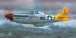
This folder contains a repaint for the 'Little Friends' package of the Warbirdsim P-51D Mustang in the colors of #44-63799 WD-L "Seneca Chief" as flown by Lt.Hugh Ottley, of the 4th FS/ 52nd FG from Madna, Italy during the winter of 1944/45. He named the aircraft after his hometown of Seneca Castle, New York. He related that when he flew the aircraft to the Naples depot at the end of the war it was 'saying goodbye to an old friend'.
Repaint by Jan Kees Blom, based on the repaint kit by Warbirdsim.
| Filename: | North_American_P51D_52nd_FG_WDL_Seneca_Chief.zip |
| License: | Freeware |
| Added: | 30th July 2018, 18:13:55 |
| Downloads: | 62 |
| Author: | Jan Kees Blom |
| Size: | 12.22 MB |
| Category: Flight Simulator 2004 - Aircraft Repaints, Textures and Modifications | |
| Britavia Handley Page HP-81 Hermes 4 (G-ALDU) |
|
Images related to this file:
File Description:
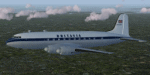
Handley Page HP81 Hermes 4 c/n 21 G-ALDU. Formerly 'Halcyone' of BOAC, purchased by Britavia on 27 May 1954. In November 1955 it became the first Hermes to cross the Atlantic. It left Blackbushe on November 14th and reached New York in 17 hr 15 min flying time via Shannon and Gander, returning via Gander in 16 hr 9 min. Transferred to Silver City Airways in July 1959. Withdrawn from use in October 1962 and broken up. These are texture files only. Prior installation of Jens B. Kristensen's Handley Page HP81 Hermes is required. Repaint by Andre Reimers.
| Filename: | Britavia_Handley_Page_HP81_Hermes_4_GALDU.zip |
| License: | Freeware |
| Added: | 25th August 2013, 21:25:23 |
| Downloads: | 96 |
| Author: | Andre Reimers |
| Size: | 3.01 MB |
| Category: Flight Simulator 2002 - Flight Plans | |
| KJFK-LIRF Original AA Flight PLan |
|
File Description:
This is the original flight plan for American Airlines flight 166 from New York Kennedy (KJFK) to Rome Fiumicino (LIRF) on May-10-03 departing at 1800L. It includes SID & STAR procedures. Note, however, that it was not planned for the default rwys in FS2002 (it is actually for RWY 13R/13L at JFK & 16C/16L at FCO) and that some waypoints and jetways are not in the FS2002 Navaid database so they were input manually. This flight was flown originally on AA B767-300ER reg. N384AA. If you have any questions feel free to e-mail me.
| Filename: | KJFKLIRF_Original_AA_Flight_PLan.zip |
| License: | Freeware |
| Added: | 20th June 2003, 04:01:25 |
| Downloads: | 424 |
| Author: | Andres Ardila |
| Size: | 672 B |
| Category: Flight Simulator 2004 - Utilities | |
| gates.to/FSNet Platform |
|
File Description:
The first and only software available today allowing you to reproduce a real cockpit environment over an Internet connection or a local LAN within FS2004. You can finally synchronize your systems so that you are able to fly the same aircraft from different locations: for example, you lower the gear while sitting in front of your PC in New York and your co-pilot gets the gear lowered on his system in Sydney as well! Having such a system finally allows for realistic pilot/co-pilot flights: doing checklists and taking care of your own duties reproducing what happen in the real world!
| Filename: | gatestoFSNet_Platform.zip |
| License: | Shareware, time limited |
| Added: | 30th December 2005, 04:36:39 |
| Downloads: | 1,130 |
| Author: | Maurizio M. Gavioli and Ugo Grandolini |
| Size: | 1.4 MB |


© 2001-2026 AVSIM Online
All Rights Reserved
Privacy Policy |