
Where Flight Simulation Enthusiasts Gather from Around the World!
AVSIM Library - Search Results

| Category: Flight Simulator X - Missions | |
| The Most Dangerous Airports: Narsarsauq |

|
Images related to this file:
File Description:
I have created the next in The Most Dangerous Airports Mission Series, namely Narsarsauq. The airport has a very unique feature, it is hidden inside a fjord and oh yes, most of the time the weather is really bad and during the long winter, the airport is closed. You have to approach from the south west and land on runway 7. You can fly the mission with the default king Air 350 or download the DHC Dash 7, it has a few gauges problems but the 3D cockpit works well.
| Filename: | The_Most_Dangerous_Airports_Narsarsauq.zip |
| License: | Freeware |
| Added: | 3rd February 2010, 02:24:37 |
| Downloads: | 1,378 |
| Author: | Robbie Albers |
| Size: | 2.82 MB |
| Category: Flight Simulator X - Missions | |
| The Most Dangerous Airports: Toncontin |
|
Images related to this file:
File Description:
I have created the next in, The Most Dangerous Airport Mission Series: namely Toncontin. The missions are real and hectic, both for you and the aircraft. The flight is a scheduled Continental Airlines flight. The Toncontin Intl is rated by some as the most dangerous airport, due to it's approach, it has a 180�° left bank, just before landing on runway 02. The airport is not so famous for this approach and numerous accidents have closed the airport in 2008 but it has been reopened after a serious upgrade.
The setting are as follows: Time and weather are set as Online Day Weather and Stormy FSX Day weaqther. Due to the runway 02 approach not being programmed into FSX, ignore the ATC vectoring and fly the approach indicated on the GPS and mission pointer. The approach is adapted from the real approach charts.
| Filename: | The_Most_Dangerous_Airports_Toncontin.zip |
| License: | Freeware |
| Added: | 24th February 2010, 05:10:45 |
| Downloads: | 2,187 |
| Author: | Robbie Albers |
| Size: | 15.9 MB |
| Category: Flight Simulator 2004 - AFCAD Files | |
| Taiwan Airports Parking, Phase 1 |
|
File Description:
This package contains AFCAD2 files to add parking spaces to default Chiayi (RCKU), Makung (RCQC), Taichung (RCLG), and Tainan (RCNN) Airports in Taiwan. The correct numbers of gates and parking spaces were used whenever possible, though the positions are purely speculative. Generated using AFCAD2 Ver. 2.11 by Lee Swordy.
| Filename: | Taiwan_Airports_Parking_Phase_1.zip |
| License: | Freeware |
| Added: | 10th December 2003, 04:48:18 |
| Downloads: | 2,564 |
| Author: | Mike Huang |
| Size: | 13.64 KB |
| Category: Flight Simulator 2004 - AFCAD Files | |
| Florida Airports KDTS and KPFN |
|
File Description:
Package includes (KDTS) Destin-Fort Walton Beach Airport, Destin, FL and (KPFN) Panama City-Bay County International Airport, Panama City, FL. Coded parking for airlines.
| Filename: | Florida_Airports_KDTS_and_KPFN.zip |
| License: | Freeware |
| Added: | 17th April 2006, 01:49:20 |
| Downloads: | 1,011 |
| Author: | Eliot Jacobs |
| Size: | 84.01 KB |
| Category: Flight Simulator 2004 - Scenery | |
| Suriname some airports and airstrips |
|
File Description:
There were missing mostly airports and airstrips in Suriname country. I created most missing and some aren't links in data. They have Blue Wings Airlines and Gum Air flying in Suriname area.
| Filename: | Suriname_some_airports_and_airstrips.zip |
| License: | Freeware |
| Added: | 14th October 2018, 17:02:15 |
| Downloads: | 376 |
| Author: | Stuart John Gilbert II |
| Size: | 8.57 MB |
| Category: Flight Simulator 2004 - Scenery | |
| Cape Verde Islands Domestic Airports |
|
Images related to this file:
File Description:
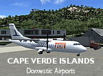
Googlyafcads and simple scenery for five airports in the Cape Verde Islands, all
of which are served by regular domestic flights of TACV - Transportes Aereos de
Cabo Verde. Each of these has been "overlooked" by Microsoft in Flight Simulator
2004 and are provided with nothing other than a runway. These scenery files add
aprons, taxiways, buildings and other airport features to Flight Simulator's bland
representation and allow you and "AI" traffic to land, taxi, park and take off
in a realistic manner.
The airports represented are: GVBA Rabil, GVMA Maio, GVSF Sao Filipe, GVSN Preguica and GVSV Sao Pedro.
The scenery does not purport to be ultra-accurate. Based on high-detail satellite
imagery from Google Earth (except Sao Filipe), the layout is proportianally correct
but the added airport features, such as buildings, are built from default Microsoft
objects and add-on libraries so will not look like the real thing. Sao Filipe is
largely imaginary owing to poor quality of the satellite image, but has been created
to be similar to other airports of like size.
You are not obliged to download and install any additional scenery libraries,
but to enjoy this scenery in its entirety, you may wish to. It will work fine,
with or without.
[File re-uploaded at request of AVSIM]
| Filename: | Cape_Verde_Islands_Domestic_Airports.zip |
| License: | Freeware |
| Added: | 15th June 2010, 01:00:46 |
| Downloads: | 7,000 |
| Author: | John Hinson |
| Size: | 84.1 KB |
| Category: Flight Simulator X - Scenery | |
| Cina International Airports: ZBHH Hohhot |
|
File Description:
Airport of Hohhot (ZBHH) in the province of Inner Mongolia, PR China, in its present state, layout based on satellite images and actual charts, buildings made with GMAX.
| Filename: | Cina_International_Airports_ZBHH_Hohhot.zip |
| License: | Freeware, limited distribution |
| Added: | 28th September 2021, 04:00:12 |
| Downloads: | 523 |
| Author: | Winfried Orthmann |
| Size: | 64.32 MB |
| Category: Flight Simulator X - Scenery | |
| Bhutan Airports and Paro Valley |
|
Images related to this file:
File Description:
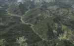
This project adds and updates all of the airports of Bhutan. Bathpalathang (VQBT) and Gelephu (VQGP) are added, Yongphulla (VQ10) is updated and recoded as VQTY, and Paro (VQPR) is fully updated to reflect current satellite imagery. These are all fully functioning AI airports as well. Special attention was given to the entire Paro Valley, and numerous road/river vectors were updated around Gelephu. Accurate coastlines, lakes, road and river data, as well as corrected landclass are provided based on the latest available satellite imagery. They are optimized to fit seamlessly with FTX Vector's roads/water, but they should be fully functional in all FSX configurations.
GA-encoded flight plans for the Buddha Air/Kathmandu charter are provided to enhance service to Paro. NASA SRTM Global 3 arc second terrain mesh is also included for all of Bhutan. Updates were created or rebuilt in a manner which carefully aligned airport data with current satellite imagery, when available. Scenery was created using Airport Design Editor X v1.61.5298, SBuilderX 3.13, and the FSX Object Placement Tool. Scenery objects were added and modified from stock FSX scenery to resemble as closely as possible the actual airports.
| Filename: | Bhutan_Airports_and_Paro_Valley.zip |
| License: | Freeware |
| Added: | 19th January 2015, 06:09:17 |
| Downloads: | 11,429 |
| Author: | Carlyle Sharpe |
| Size: | 21.4 MB |
| Category: Flight Simulator X - AFCAD Files | |
| Australian Capital Cities & Regional Airports |
|
File Description:
This is a basic update of FSX default Australian Capital City & Regional Airports BGL airport files.
Many gates have been resized where possible to enable larger aircraft such as b747s, A380s park in the international terminals. I have also added several gates to a number of airports and assigned ATC (airline) parking codes to all the parking spots. These parking codes have been aligned to the correct terminals. Military parking spots have also been added to many airports.
Note Melbourne airport (YMML) has also been updated from my last posting.
The airports included in this pack include:
Melbourne Intl - YMML; Canberra - YSCB (includes military); Sydney Intl - YSSY; Brisbane Intl - YBBN; Darwin Intl - YPDN (includes military); Perth Intl - YPPH; Adelaide Intl - YPAD; Hobart Intl - YMHB; Albury - YMAY; Cairns Intl - YBSC; Townsville - YBTL (includes military); Gold Coast - YBCG; Launceston - YMLT; Devonport - YDPO; East Sale (Military) - YMES
These BGL AFCAD files has been tested with VOZ, PAI and RAAF AI aircraft.
There are 15 BGL AFCAD files in this download.
| Filename: | Australian_Capital_Cities__Regional_Airports.zip |
| License: | Freeware |
| Added: | 13th October 2007, 10:38:57 |
| Downloads: | 6,354 |
| Author: | Garry Appleby |
| Size: | 2.09 MB |
| Category: Flight Simulator X - Missions | |
| The Most Dangerous Airports: Lukla |
|
Images related to this file:
File Description:
I have created the next in, The Most Dangerous Airport Mission Series: namely Lukla. This is a mission is a simulation of Yeti Arlines flight into Lukla. The Lukla approach is very unusual because there is no turn-around one attempt and one landing. Pratice before hand is in order.
| Filename: | The_Most_Dangerous_Airports_Lukla.zip |
| License: | Freeware |
| Added: | 3rd June 2010, 01:39:40 |
| Downloads: | 1,849 |
| Author: | Robbie Albers |
| Size: | 17.89 MB |


© 2001-2026 AVSIM Online
All Rights Reserved
Privacy Policy |