
Where Flight Simulation Enthusiasts Gather from Around the World!
AVSIM Library - Search Results

| Category: Flight Simulator 2004 - Scenery | |
| FS9 Fort St John CYXJ in BC Canada |

|
File Description:
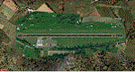
Fort St John is close to the border between British Columbia and Alberta, around 40 miles north-northwest of Dawson Creek. The airport was originally a Royal Canadian Air Force base, associated with the wartime construction of the Alaska Highway. The airfield was part of this construction effort and the wartime ferrying of planes to Russia. It is currently named "North Peace Regional Airport", or "North Peace Airport"; apparently there has been no final decision?
The date for this scenery is around 2006. I was given an old video tape cassette which was filmed on an uncertain date, but which had to be before the terminal building was renovated in 2007 and totally changed in appearance. The only way to view the video was to play it in the camera and watch it on a small screen. After I had completed everything except the buildings I started to view the video to establish the building appearances and within an hour or so the camera died. It was so old there was no way to repair it, so I then made some new buildings from memory of the video and what was available online. I also used some that I had already made for other scenery but which were similar. I may replace the terminal building that is in this version with a build of the new one, as I know this one is not a very accurate reproduction. The replacement, if I do it, will be towards the end of this year.
The AI included here is for GA, Air Canada Jazz, and two helicopter companies that were (and still are?) based there. One is at the western end of the apron and the other is at the eastern end but separated from the apron. To gain access to the taxiways and runways (so that all airport users follow the same procedures, for safety reasons) the eastern end helicopters just taxi across the grass. The helicopters are used for maintenance trips to the oil and gas fields in the surrounding area. My screenshots show Westjet at the terminal; this is because I have later Canadian AI installed, while the AI included here is only for the time around 2000 to 2010, when Westjet were not flying to Fort St John.
The airport is square in plan, with the apron running along the northern side and two runways forming diagonals. The two runways are 11-29 (6,882 feet long and 200 feet wide, with ILS at the 29 end and PAPI at the other) and 02-20 (6,684 feet long and 200 feet wide, and with PAPI at each end). The eastern side taxiway that runs north-south is not used. The western side taxiway is in use but only as a race track for cars.
Please email me if you find faults, such as a plane without textures.
| Filename: | FS9_Fort_St_John_CYXJ_in_BC_Canada.zip |
| License: | Freeware, limited distribution |
| Added: | 10th October 2022, 14:03:38 |
| Downloads: | 210 |
| Author: | Roger Wensley |
| Size: | 37.49 MB |
| Category: Flight Simulator 2004 - AI Aircraft | |
| Singapore Airlines Airbus A300 in 1980's livery |
|
File Description:
Repaint of the Fspainter Airbus A300 in 1980's Singapore Airlines livery for retro ai traffic. Flightplans by Stefan Fisher should be available soon from retroai.org
| Filename: | Singapore_Airlines_Airbus_A300_in_1980s_livery.zip |
| License: | Freeware |
| Added: | 11th October 2007, 22:19:42 |
| Downloads: | 320 |
| Author: | Nick Prestwich |
| Size: | 469.93 KB |
| Category: Flight Simulator X - Aircraft Repaints, Textures and Modifications | |
| Indian Navy Boeing P-8I Neptune (IN 321) |
|
Images related to this file:
File Description:

Indian Navy P-8I Neptune IN321 for the payware PMDG 737 NGX. Textures only you must own the PMDG NGX 8/900 base pack and have updated to version 1.10.6461 that included the US Navy P-8A. Livery Manager install.
The Boeing P-8I Neptune is the Indian Navy's custom variant of the US Navy's P-8A Poseidon. There are to be at least eight P-8I's, 6 of which have already been delivered. An Indian P-8I was recently involved in the search for MH-370.
| Filename: | Indian_Navy_Boeing_P8I_Neptune_IN_321.zip |
| License: | Freeware, limited distribution |
| Added: | 26th July 2015, 11:49:49 |
| Downloads: | 623 |
| Author: | John O'Duffy |
| Size: | 22.39 MB |
| Category: Flight Simulator 2004 - Aircraft Repaints, Textures and Modifications | |
| F8 Crusader in a fictional Blue Angels scheme |
|
Images related to this file:
File Description:
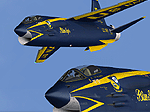
Re-uploaded ALPHASIM F8 Crusader in a fictional Blue Angels scheme.
| Filename: | F8_Crusader_in_a_fictional_Blue_Angels_scheme.zip |
| License: | Freeware |
| Added: | 11th May 2010, 23:26:41 |
| Downloads: | 328 |
| Author: | Repaints by pierre lheureux - Plane by Alphasim |
| Size: | 3.25 MB |
| Category: Flight Simulator X - Scenery | |
| Air Station Poznan Lawica in the interwar years |
|
File Description:
Air Station Poznan-Lawica is one of the oldest airports in Poland. Built in 1913 as an Imperial German airbase (Fliegerstation Lawitz). During the Wielkopolskie (Greater Poland) Uprising on January 6, 1919 was captured by insurgents. As the first insurgent air unit, began to play a very important role in the development of Polish aviation and Polish Air Force.
The Air Station Poznan-Lawica was one of the most important Polish airports in the interwar years.
| Filename: | Air_Station_Poznan_Lawica_in_the_interwar_years.zip |
| License: | Freeware, limited distribution |
| Added: | 28th October 2014, 12:33:07 |
| Downloads: | 645 |
| Author: | Rob Kowalski |
| Size: | 16.05 MB |
| Category: Flight Simulator X - Miscellaneous Files | |
| Creating VIP Parking in FSX - an Illustrated Guide. |
|
File Description:
Creating VIP Parking in FSX - an Illustrated Guide. After landing your favorite FSX aircraft, are you frustrated by ATC directing you to a gate which is nowhere near a logical spot? This guide shows how to create a reserved parking gate at any airport and have ATC direct you properly to that gate. This concept will work for a specific aircraft of your choice. The technique is based upon investigations and information developed by Jim Vile and Reggie Fields. Please unzip to a temporary folder and read the directions carefully. Compiled in Doc and PDF formats for your flying enjoyment by David "Opa" Marshall.
| Filename: | Creating_VIP_Parking_in_FSX__an_Illustrated_Guide.zip |
| License: | Freeware |
| Added: | 27th August 2008, 00:06:13 |
| Downloads: | 2,182 |
| Author: | Jim Vile & David "Opa" Marshall |
| Size: | 770.29 KB |
| Category: Flight Simulator 2004 - Scenery | |
| Maurice Bishop TGPY on Grenada in the Caribbean |
|
Images related to this file:
File Description:
Grenada island is 17 miles south of the southernmost island of the Grenadines, Carriacou; there are some smaller islands between the two. Grenada is 18 miles long and around 8 miles wide, has an estimated population of 110,000, and produces a very large part of the world's annual nutmeg harvest. The capital, St Georges, is by far the largest town and is at the southern end of the island, with the airport close by.
The airport is now called Maurice Bishop, but for some years was called Point Salines. The runway is just over 9,000 feet long and oriented 10/28. Point Salines replaced Pearl Airport, which is on the east coast 12 miles northeast of St Georges and was difficult to expand as the runway had mountains at one end and the sea at the other. Pearl is now closed; it is included here but only as a visual landmark with "closed" markings. There are regular international flights from North America and Europe, some of which are seasonal only (Air Canada for instance) and local connecting flights by LIAT and SVG. I retained the default control tower as it is some distance away. In real life it is also some distance away and on a hill northwest of the terminal. Which is why I did not take photos from which I would have made the real one. The hill does not feature in FS9.
| Filename: | Maurice_Bishop_TGPY_on_Grenada_in_the_Caribbean.zip |
| License: | Freeware, limited distribution |
| Added: | 11th June 2013, 23:28:17 |
| Downloads: | 825 |
| Author: | Roger Wensley |
| Size: | 7.38 MB |
| Category: Flight Simulator 2004 - Scenery | |
| Lost Cities in FS2004: Cities & Towns Of Island |
|
File Description:
Lost Cities in FS2004: Island - Keflavik & Co
In the default scenery of FS2004 many Cities do not exist. This time I represent you the follwoing lost towns of Island
in the near of Keflavik Airport, including: Keflavik, Byjarsker, Vogar, Grinfavik, Njardhvikur and more.
Also pay attention to my other files by Dave Sheffield:
Lost Cities of Malta
Real Landclass of Nürnberg
Real Landclass of Dublin incl. the Town of Swords
Real Landclass of Manchester
| Filename: | Lost_Cities_in_FS2004_Cities__Towns_Of_Island.zip |
| License: | Freeware |
| Added: | 31st August 2008, 22:52:45 |
| Downloads: | 2,615 |
| Author: | Dave Sheffield |
| Size: | 6.15 KB |
| Category: Flight Simulator 2004 - Scenery | |
| Alaska North Slope 10; Kivalina KVL in Alaska |
|
Images related to this file:
File Description:
The town of Barrow is in the far north of Alaska, and these are coastal villages or radar installations to the west, south, and east of Barrow on the North Slope. There will be further additions. Kivalina is a small village (population around 350) midway in the 150 mile gap between Point Hope to the north and Kotzebue to the south. The village is on a spit of land that is growing smaller and smaller with every year of erosion and the rise of sea level. The runway is 3,500 feet of gravel aligned 12-30 to the north of the village on the same spit. It was expected that 2025 would see the end of both village and runway, and possibly also the natural harbour that is the reason for the village's location. The modified width of the spit shown here is halved from the original FS9, and erosion has continued, enough that a sea defence wall has now been built. The AI has a daily flight by an ERA Alaska Cessna 208B, and some GA; read the note about the 208 to be downloaded and/or properly installed.
| Filename: | Alaska_North_Slope_10_Kivalina_KVL_in_Alaska.zip |
| License: | Freeware, limited distribution |
| Added: | 27th July 2016, 21:12:15 |
| Downloads: | 242 |
| Author: | Roger Wensley |
| Size: | 2.87 MB |
| Category: Flight Simulator 2004 - Scenery | |
| "Caiolo" Sondrio Airport, Valtellina, North Italy |
|
Images related to this file:
File Description:
In this airport reside AvioValtellina and VolaValtellina, as well as the operational base of the Health Service 118 and Mountain Rescue. It also base of the Aeroclub Sondrio with its Flight School VDS. Site at the beginning of the Valtellina, in Caiolo municipality (N46 09.0 E09 48.0), has an asphalt runway from 1050x23 mts, ground communication frequency 129.50; ICAO code: LILO. It is also enclosed the base of INAER Aviation, located in Colico-Piantedo (N46 08.18 E09 24.19 - code LIEI), that operates in Medical Emergency, rescue operations in the mountains and off-shore. Scenery realized on the real cooordinates of the airport (except for elevation) including the scenery of the heliport INAER Colico. Requires the use of the libraries' dva51 "and the system of vegetations "TreePlanter".
Enjoy!
A presentation video is available here.
| Filename: | Caiolo_Sondrio_Airport_Valtellina_North_Italy.zip |
| License: | Freeware |
| Added: | 25th October 2014, 11:52:25 |
| Downloads: | 856 |
| Author: | Aldo Della Vedova |
| Size: | 29.5 MB |
© 2001-2026 AVSIM Online
All Rights Reserved
Privacy Policy |