
Where Flight Simulation Enthusiasts Gather from Around the World!
AVSIM Library - Search Results

| Category: Flight Simulator X - Miscellaneous Files | |
| Flight Simulator X in Google Earth |

|
File Description:
This zip contains all the airports & navaids for Flight Simulator X and includes all comms and nav frequencies, runway details along with any relevant ILS information. Extracted from the default FSX BGL scenery files in Nov 2006.
| Filename: | Flight_Simulator_X_in_Google_Earth.zip |
| License: | Freeware |
| Added: | 16th November 2006, 20:53:45 |
| Downloads: | 9,763 |
| Author: | Ian Niblo |
| Size: | 2.16 MB |
| Category: Flight Simulator 2004 - Scenery | |
| Union Island TVSU in the Grenadines |
|
Images related to this file:
File Description:
Union Island is in the southern tail of the chain of islands known as St Vincent and the Grenadines, between Canouan and Carriacou. Union is another small island, 3.5 miles long and at its widest 1.5 miles wide; the resident population is around 3,000, mostly in the two towns Clifton and Ashton.
The airport is at the eastern end of the island, and has been extended into the sea on landfill. The runway is now around 2,480 feet long, aligned 08 (and with the southeast trade winds it is unlikely that you will find yourself using 26) and with a displaced threshold of 530 feet due to the hill to the west. The terminal is adjacent to a rather small apron; there is parking on the grass north of the taxiway. There are connecting flights by SVG to Barbados and the other islands and these are reflected in the AI. The airport has no lighting, and flights are obliged to land and depart in daylight hours only, outside of which the airport is closed.
| Filename: | Union_Island_TVSU_in_the_Grenadines.zip |
| License: | Freeware, limited distribution |
| Added: | 11th June 2013, 23:26:50 |
| Downloads: | 434 |
| Author: | Roger Wensley |
| Size: | 2.02 MB |
| Category: Flight Simulator X - Scenery | |
| Roros Airport (ENRO) in Roros, Norway |
|
Images related to this file:
File Description:
Roros Airport (IATA: RRS, ICAO: ENRO; Norwegian: Roros lufthavn) is a regional airport located 2 kilometers (1.2 mi) from the town of Roros, Norway. The asphalt runway has the physical dimensions 1,740 by 40 meters (5,710 by 130 ft) and is aligned 14/32. Scheduled services are provided to Oslo by Wideroe. The main general aviation user is Rørosfly, a pilot school, and the aviation club Roros Flyklubb. (Source of information: Wikipedia August 20, 2016)
| Filename: | Roros_Airport_ENRO_in_Roros_Norway.zip |
| License: | Freeware |
| Added: | 20th August 2016, 15:40:59 |
| Downloads: | 680 |
| Author: | Hans Christian Knudsen and Knudsenair Simulations |
| Size: | 121.82 KB |
| Category: Flight Simulator X - AFCAD Files | |
| Luena airport (ICAO: FNUE) in Angola |
|
File Description:
The Luena airport (ICAO: FNUE) in Angola.
Create the apron, the taxiways, add default buildings and signs.
The stock FSX airport has only the runway and nothing else.
Made it with Airport Design Editor
| Filename: | Luena_airport_ICAO_FNUE_in_Angola.zip |
| License: | Freeware |
| Added: | 24th November 2017, 17:25:37 |
| Downloads: | 340 |
| Author: | Giannis Dedes |
| Size: | 3.23 KB |
| Category: Flight Simulator 2004 - Scenery | |
| Nenana Municipal Airport PANN in Alaska |
|
Images related to this file:
File Description:
Nenana is a village on the river of the same name around 40 miles west of Fairbanks, which is the second largest urban area in Alaska after Anchorage. Nenana, as a result of this proximity, is served by road and railway and unlike other Alaskan villages is not reliant on air cargo for necessities. The current population is just under 400, which is way down from its peak of 5,000 in the 1920's when gold was being mined and the railroad being built. Nenana's main claim to fame is as the starting point for the 1925 mushing delivery to Nome of the serum to combat an outbreak of diphtheria. Any Nenana Municipal Airport history is difficult to find, even the date of construction. It has two runways 3L-21R and 3R-21L, the first being asphalt and just under 5,000 feet with PAPI at both ends, the second grass and 1,800 feet. Both are lit. It also has a further water runway similarly aligned and 3,000 feet long. Maintenance is available and there is also fuel at the end of the northern apron, close to the crashed and stripped DC4 that sits among other unwanted items that are too large to make it worth the cost of moving them off the site. There are no regular scheduled flights to the airport, with air taxi or owner operated being in the majority. The scenery, in addition to the terrain, town, bridges, and airport items also modifies the terrain in an area further south where FS9 depicted as a city an Air Force base that is mainly concerned with radar and communications and in fact has very few buildings. The AI includes some Beavers on floats that were used in previous BC scenery with the kind permission of FSAddon. As I have already posted them I have not included them again here. The float plane AI uses the same radio frequency as the land based planes, but they fly to PANX and not to PANN as FS9 has problems with getting floats and wheels separated. Or maybe I just haven't worked out how to cope with FS9. A note here about my scenery making. There will not be many more to follow this as I am almost at the end of the photos I either took or found for scenery purposes, plus I expect to move on from FS9 at some point during next year.
| Filename: | Nenana_Municipal_Airport_PANN_in_Alaska.zip |
| License: | Freeware, limited distribution |
| Added: | 2nd December 2019, 18:12:42 |
| Downloads: | 154 |
| Author: | Roger Wensley |
| Size: | 7.36 MB |
| Category: Flight Simulator 2004 - Scenery | |
| Baker Lake CYBK in Nunavut, Canada |
|
Images related to this file:
File Description:
Baker Lake is the only Nunavut community that is not next to the sea. It is, as you might have guessed, on the shore of Baker Lake and 160 miles west and a bit north of Rankin Inlet on the shore of Hudson Bay (a recent post by Sid and Pete). The Hudson Bay Company opened a trading post there in 1916 and the town slowly developed, though as recently as 1946 the population was still only 32. These days the airfield is the support field for several nearby mines and there are now nearly 1,800 folks in Baker Lake using the stores, schools, churches, hospital, etc. The runway is almost 4,200' of 100' wide gravel and lighted; the alignment is 162T and 342T as this is in northern domestic airspace and bearings are given as 'true" and not "magnetic". Both JETA and 100LL fuel is available. The town is to the northeast of the airfield and is made up of a landclass without autogeneration, as this would mean a bunch of trees that would be, to say the least, unrealistic.
| Filename: | Baker_Lake_CYBK_in_Nunavut_Canada.zip |
| License: | Freeware, limited distribution |
| Added: | 23rd November 2011, 09:21:56 |
| Downloads: | 513 |
| Author: | Roger Wensley |
| Size: | 2.45 MB |
| Category: Flight Simulator 2004 - Scenery | |
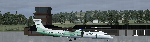
| Port of Spain waterfront in Trinidad |
|
File Description:
Port of Spain is the capital of Trinidad and Tobago and happens to be where I am right now. As the flying down here is completely different to Canada (the only direction to go is north up the chain of islands, unless you want to be a suspected drug smuggler) and there aren't a whole bunch of airfields to model I turned my attention to the waterfront as a place where a floatplane would tie up. The result is here, and makes the harbour and some of the city more realistic. I had to use Lago for some of the buildings in the city itself but if you've never been to Trinidad then it won't make any diference to you if they're missing.
| Filename: | Port_of_Spain_waterfront_in_Trinidad.zip |
| License: | Freeware |
| Added: | 20th October 2007, 17:05:30 |
| Downloads: | 2,196 |
| Author: | Roger Wensley and Jim Turner |
| Size: | 1.29 MB |
| Category: Flight Simulator 2004 - Aircraft Repaints, Textures and Modifications | |
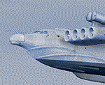
| Grumman A6E intruder in NATC colors |
|
Images related to this file:
File Description:
Re-uploaded AlphaSim Grumman A6E intruder in NATC colors, NAval Air Test Center, Patuxent River.
| Filename: | Grumman_A6E_intruder_in_NATC_colors.zip |
| License: | Freeware |
| Added: | 13th May 2010, 21:09:42 |
| Downloads: | 497 |
| Author: | Repaints by pierre lheureux - Plane by Alphasim |
| Size: | 3.65 MB |
| Category: Flight Simulator 2004 - Aircraft Repaints, Textures and Modifications | |
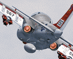
| Ekranoplan "LUN" in Soviet Navy scheme |
|
Images related to this file:
File Description:
Re-uploaded Soviet Navy scheme for Alphasim Ekranoplan "LUN".
| Filename: | Ekranoplan_LUN_in_Soviet_Navy_scheme.zip |
| License: | Freeware |
| Added: | 13th May 2010, 21:08:23 |
| Downloads: | 232 |
| Author: | Repaints by pierre lheureux - Plane by Alphasim |
| Size: | 1.92 MB |
| Category: Flight Simulator 2004 - Scenery | |
| Small Airports in the Chilean Patagonia |
|
File Description:
AIRDROMES TTE. JULIO GALLARDO AND TTE vIDAL, IN CHILE,
FOR FS2004 - ACOF
These are the regional airports of the cities of Coyahique and Puerto Natales in southern Chile. Pto. Natales is the center of operations for those visiting the famous national park Torres de Paine. Coyahique is a small city in the cattle region of Chile surrounded by mountains and lush vegetation; this airdrome is a lot of fun to fly to. Includes a very detailed reproduction of terminal buildings, grounds, and other installations. All the most important buildings and airport facilities are recreated with realistic Day/Night time effects. File 1 of 2 (Requieres Patagon3.zip).
By Cesar Carrasco; NYC
| Filename: | Small_Airports_in_the_Chilean_Patagonia.zip |
| License: | Freeware |
| Added: | 26th February 2006, 04:11:32 |
| Downloads: | 1,463 |
| Author: | César Carrasco |
| Size: | 225.44 KB |
© 2001-2026 AVSIM Online
All Rights Reserved
Privacy Policy |