
Where Flight Simulation Enthusiasts Gather from Around the World!
AVSIM Library - Search Results

| Category: Flight Simulator 2004 - Scenery | |
| New Terrain Mesh of the Province of Quebec in LOD09 (2/4) |

|
File Description:
The files in this package contain terrain mesh files of the province of Quebec (N45 to N53) to be used with my Quebec enhanced sceneries for FS2004 (Scenes_du_Quebec_2k4.zip). The public data sources are the Shuttle Radar Topography Mission (SRTM-3, 90m) and the Canadian Digital Elevation Data (CDED - 0.75s/arc - 23m). (QC09_2k4a.zip to QC09_2k4d.zip - 4 parts)
***********************
Les fichiers de ces archives contiennent les donnees d'elevation de terrain (mesh files - lod09), pour FS2004, du territoire de la province de Quebec sous le 53ieme degre de latitude nord. Ils ont ete crees pour etre utilises avec mes nouvelles scenes du Quebec contenues dans Scenes_du_Quebec_2k4.zip. Les donnees sources sont du domaine public et proviennent de la Shuttle Radar Topography Mission (SRTM-3, 90m) et des donnees numerique d'elevation du Canada (DNEC - 0.75s/arc -23 m). (QC09_2k4a.zip to QC09_2k4d.zip - 4 parties)
| Filename: | New_Terrain_Mesh_of_the_Province_of_Quebec_in_LOD0.zip |
| License: | Freeware, limited distribution |
| Added: | 1st November 2009, 06:47:09 |
| Downloads: | 4,628 |
| Author: | Gilles Gauthier |
| Size: | 27.78 MB |
| Category: Prepar3D V1-4 - Scenery | |
| Bloukrans and Storms River (Paul Sauer) bridges – South Africa |
|
Images related to this file:
File Description:
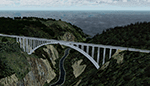
The Bloukrans and Paul Sauer (over the Storms river) bridges are on the N2 highway between Plettenberg Bay and Port Elizabeth on the scenic garden route in the Eastern Cape, South Africa. I made the custom scenery to try some Blender techniques using the P3D 4.5 SDK and tested it in P3D V5 using the ORBX Africa LC and Pilots NG2020 mesh products (I included a fix for the default V5 mesh). You will find the world's highest commercial bungee jump from the Bloukrans bridge, 216m above the river below. Take off from FAPG and fly a heading of 95 degrees for 32 km to get to the Bloukrans bridge (just off the coast). Follow the highway further east for another 26 km to get to the 120m high Paul Sauer bridge, where I included some additional eye candy.
| Filename: | Bloukrans_and_Storms_River_Paul_Sauer_bridges__Sou.zip |
| License: | Freeware |
| Added: | 14th July 2020, 19:15:53 |
| Downloads: | 180 |
| Author: | Johan Pienaar |
| Size: | 26.95 MB |
| Category: Flight Simulator 2004 - Scenery | |
| Igloolik CYGT update (to FSGenesis 76m North Canada Terrain Mesh revision) |
|
Images related to this file:
File Description:
These are replacement bgl's and textures to correct the already posted Igloolik CYGT for use with the FSGenesis 76m terrain mesh for northern Canada. I noticed after posting that the PAPI were incorrectly positioned, and after fixing that I went on and updated the windsocks, added the wheeled roller/snow clearer that all gravel fields need in the north, and updated the signage to give the true headings for the runway. This is not stand-alone, and the presumption is that you have already downloaded and installed the previously posted scenery. Installation consists solely of replacing the existing scenery bgl's with the new, and adding the new signage textures.Any comments regarding further corrections that are required would be welcomed.
| Filename: | Igloolik_CYGT_update_to_FSGenesis_76m_North_Canada.zip |
| License: | Freeware, limited distribution |
| Added: | 30th September 2017, 20:11:03 |
| Downloads: | 84 |
| Author: | Roger Wensley |
| Size: | 1.03 MB |
| Category: Flight Simulator 2004 - Scenery | |
| Backcountry airfields for 19m terrain mesh in Idaho USA series 2 |
|
Images related to this file:
File Description:
These backcountry fields are for use with the FSGenesis 19m mesh of Idaho; they almost certainly do not work without it. The six airfields are a follow-on series to the previous four, ranging from Stanley that has a village and airfield buildings of one sort or another and even a length of asphalt runway, to Bruce Meadows that has two bathrooms. The full list from northwest to southeast is Bruce Meadows U63, Garden Valley U88, Warm Springs Creek 0U1, Stanley 2U7, Graham U45, and Smiley Creek U87. These airfields compensate for the loss of airfield flattens after the removal of AF917150 and AF917160, but there remain some now-unflattened airfields I have not included here, whether for reason of the impossibility of realistically creating it (as in the case of Flying B) or just a total lack of anything interesting about it. There may be some more follow-on fields that are new, to the north of the original four; these six are all to the south. The landclass files either change forested areas, as in Bruce Meadows, or add a village, as in Stanley. Although these are stand-alone, the presumption is that you have already installed the original four for use with the FS Genesis 19m terrain mesh, and there is a correction for Big Creek where I missed spotting a lack of flatten in one area.
| Filename: | Backcountry_airfields_for_19m_terrain_mesh_in_Idah.zip |
| License: | Freeware, limited distribution |
| Added: | 29th May 2017, 04:20:10 |
| Downloads: | 111 |
| Author: | Roger Wensley |
| Size: | 9.09 MB |
| Category: Flight Simulator 2004 - Scenery | |
| Vance W. Amory International Airport, St Kitss and Nevis (TKPN), Update to version 1.1 |
|
Images related to this file:
File Description:
This zip-file contains a update to version 1.1 of my scenery for the Vance W. Amory International Airport in St. Kitts and Nevis. Original version 1.0 is required. Update contains:
- Removed flatten-area which conflicted with default FS9 mesh terrain settings.
- Corrected AFCAD file
- Fixed some small bugs
- New displaced threshold markings
- Modified windsocks
- Added working marshalers on parking spot 1 & 2 (front of the terminal)
| Filename: | Vance_W_Amory_International_Airport_St_Kitss_and_N.zip |
| License: | Freeware, limited distribution |
| Added: | 2nd April 2010, 01:24:50 |
| Downloads: | 1,828 |
| Author: | Marcel Ritzema |
| Size: | 57.77 KB |
| Category: Flight Simulator 2002 - Scenery | |
| The Cornwall China Clay Pits |
|
File Description:
This scenery represents the China clay pits at St Austell, Cornwall UK
It features the huge white clay tips and deep open cast mines in that area.
Know as the white mountains in Cornwall it is a very visible VFR object, excellent
for lining up for StMawgan AB.
Designed for use with addon mesh terrain such as Visual Flight's UKie2a and Lago's Terramesh
for the UK.
| Filename: | The_Cornwall_China_Clay_Pits.zip |
| License: | Freeware |
| Added: | 20th November 2002, 13:07:34 |
| Downloads: | 748 |
| Author: | Nick Ryall |
| Size: | 25.85 KB |
| Category: Flight Simulator 2002 - Scenery | |
| Italy Altiports Chamois and Tonal |
|
File Description:
Chamois and Tonal Passo are two Italian altisurfaces with sharp sloped bush runways. Chamois is located in the Valley of Aoste, NE of Aosta LIMW airport, in the valley which goes back vis-a-vis to the MT Cervin. Tonale Passo is located at the pass of Tonale in Dolomites, in the West of Bolzano LIPB. Best enjoyed with shareware mesh terrain by Thierry Pignot, pictures included.
| Filename: | Italy_Altiports_Chamois_and_Tonal.zip |
| License: | Freeware |
| Added: | 23rd November 2002, 19:31:52 |
| Downloads: | 2,495 |
| Author: | Guy Menoz |
| Size: | 2.33 MB |
| Category: Flight Simulator 2002 - Scenery | |
| Tamar Suspension Bridges |
|
File Description:
This scenery represents the 2 Suspension Bridges between Plymouth in Devon and Saltash in Cornwall UK, The rail bridge was built by the famous engineer Isambard Kingdom Brunel and the model has an animated regional railways train crossing back and forth. The road bridge was built in 1961 and recently strengthened to take 2 more lanes of traffic Designed for use with addon mesh terrain.
| Filename: | Tamar_Suspension_Bridges.zip |
| License: | Freeware |
| Added: | 29th October 2002, 15:37:01 |
| Downloads: | 2,109 |
| Author: | Nick Ryall |
| Size: | 464.93 KB |
| Category: Flight Simulator 2002 - Adventures | |
| FS2002 VFR Adventure - Wollongong to Canberra |
|
File Description:
Cross-country flight to Australia's capital
city. Features: Real background ATC specific
to each frequency, on-board virtual pilot
who reads out tracks, headings and ETA’s &
DME's, audio checklist (Warrior specific),
pre-flight briefing documentation & charts.
Special mesh and landclass scenery included.
Around 280 individually recorded sound files
make up this adventure to produce a rich
& realistic sound environment. For the
serious-minded VFR pilot.
| Filename: | FS2002_VFR_Adventure__Wollongong_to_Canberra.zip |
| License: | Freeware, limited distribution |
| Added: | 12th April 2003, 17:03:34 |
| Downloads: | 1,844 |
| Author: | Fermin Fernandez & John Dow |
| Size: | 11.33 MB |
| Category: Orbiter - Spaceships | |
| Atlantis Mod 1.5a |
|
File Description:
This is a modification of the Space Shuttle Atlantis. These issues have been adressed in this mod: - Attitude control by thrust vectoring - Full Autopilot during launch - Custom exhaust flames - Possible engine failures - Gravity gradient - Aerodynamic control surfaces - Speed brake - Trim during reentry - Drogue chute after landing.
This is a bugfix. The previously missing mesh is included, the "ghost" flame after SRB separation has been removed.
| Filename: | Atlantis_Mod_15a.zip |
| License: | Freeware |
| Added: | 10th May 2003, 10:24:13 |
| Downloads: | 8,291 |
| Author: | Richard Craig, Francis Drake, Damir Gulesich, David Sundstrom |
| Size: | 1.07 MB |


© 2001-2026 AVSIM Online
All Rights Reserved
Privacy Policy |