
Where Flight Simulation Enthusiasts Gather from Around the World!
AVSIM Library - Search Results

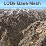
| Category: Flight Simulator 2004 - Scenery | |
| Himalayas LOD9 Base Mesh, Volume 3 - Southwestern Ranges |

|
Images related to this file:
File Description:

Detailed terrain mesh of the Southwestern Himalayan Ranges, N28-37 E78-82. The files in this package are based on Shuttle Radar (SRTM) Version 2 data but with many of the void areas, especially the most significant sections, filled with elevation data generated from topographic maps by Jonathan de Ferranti. While Jonathan's work is unrelated to flight simulation he kindly gave me permission to compile his data for use in FS. The result is a wonderful improvement in detail and accuracy over any existing mesh file, freeware or commercial, based on SRTM or DTED data alone.
Due to the large area of the Himalayas I've compiled the source data as two separate series: the "Himalayan Peaks" series covers prominent mountains and ranges in higher detail and locally overrides any existing LOD9 terrain mesh. In addition, the LOD9 "base mesh" series, with LOD8 and LOD7 "buffer" mesh files, covering the entire Himalayas, is meant for those who do not yet have an add-on terrain mesh of these beautiful mountains.
| Filename: | fs_him_b3.zip |
| License: | Freeware, limited distribution |
| Added: | 30th May 2010, 10:00:26 |
| Downloads: | 155,793 |
| Author: | Holger Sandmann, Jonathan de Ferranti |
| Size: | 62.16 MB |
| Category: Flight Simulator 2004 - Scenery | |
| Himalayas LOD9 Base Mesh, Volume 4 - Kashmir and Jammu |
|
File Description:
Detailed terrain mesh of the Kashmir and Jammu Ranges, N30-39 E76-78. The files in this package are based on Shuttle Radar (SRTM) Version 2 data but with many of the void areas, especially the most significant sections, filled with elevation data generated from topographic maps by Jonathan de Ferranti. While Jonathan's work is unrelated to flight simulation he kindly gave me permission to compile his data for use in FS. The result is a wonderful improvement in detail and accuracy over any existing mesh file, freeware or commercial, based on SRTM or DTED data alone.
Due to the large area of the Himalayas I've compiled the source data as two separate series: the "Himalayan Peaks" series covers prominent mountains and ranges in higher detail and locally overrides any existing LOD9 terrain mesh. In addition, the LOD9 "base mesh" series, with LOD8 and LOD7 "buffer" mesh files, covering the entire Himalayas, is meant for those who do not yet have an add-on terrain mesh of these beautiful mountains.
| Filename: | Himalayas_LOD9_Base_Mesh_Volume_4__Kashmir_and_Jam.zip |
| License: | Freeware, limited distribution |
| Added: | 22nd February 2006, 20:32:50 |
| Downloads: | 7,491 |
| Author: | Holger Sandmann, Jonathan de Ferranti |
| Size: | 29.24 MB |
| Category: Flight Simulator 2004 - Scenery | |
| Himalayas LOD9 Base Mesh, Volume 5 - Hindu Kush and Pamir |
|
Images related to this file:
File Description:
Detailed terrain mesh of the Hindu Kush and Pamir Ranges, N32-40 E70-76. The files in this package are based on Shuttle Radar (SRTM) Version 2 data but with many of the void areas, especially the most significant sections, filled with elevation data generated from topographic maps by Jonathan de Ferranti. While Jonathan's work is unrelated to flight simulation he kindly gave me permission to compile his data for use in FS. The result is a wonderful improvement in detail and accuracy over any existing mesh file, freeware or commercial, based on SRTM or DTED data alone.
Due to the large area of the Himalayas I've compiled the source data as two separate series: the "Himalayan Peaks" series covers prominent mountains and ranges in higher detail and locally overrides any existing LOD9 terrain mesh. In addition, the LOD9 "base mesh" series, with LOD8 and LOD7 "buffer" mesh files, covering the entire Himalayas, is meant for those who do not yet have an add-on terrain mesh of these beautiful mountains.
| Filename: | fs_him_b5.zip |
| License: | Freeware, limited distribution |
| Added: | 29th May 2010, 08:57:29 |
| Downloads: | 7,590 |
| Author: | Holger Sandmann, Jonathan de Ferranti |
| Size: | 85.72 MB |
| Category: Flight Simulator 2004 - Scenery | |
| Himalayas LOD9 Base Mesh, Volume 1 - Southeastern Ranges |
|
Images related to this file:
File Description:

Detailed terrain mesh of the Southeastern Himalayan Ranges, N26-32 E90-98. The files in this package are based on Shuttle Radar (SRTM) Version 2 data but with many of the void areas, especially the most significant sections, filled with elevation data generated from topographic maps by Jonathan de Ferranti. While Jonathan's work is unrelated to flight simulation he kindly gave me permission to compile his data for use in FS. The result is a wonderful improvement in detail and accuracy over any existing mesh file, freeware or commercial, based on SRTM or DTED data alone.
Due to the large area of the Himalayas I've compiled the source data as two separate series: the "Himalayan Peaks" series covers prominent mountains and ranges in higher detail and locally overrides any existing LOD9 terrain mesh. In addition, a LOD9 "base mesh" series, with LOD8 and LOD7 "buffer" mesh files, covering the entire Himalayas, is meant for those who do not yet have an add-on terrain mesh of these beautiful mountains.
| Filename: | fs_him_b1.zip |
| License: | Freeware, limited distribution |
| Added: | 29th May 2010, 09:01:26 |
| Downloads: | 10,274 |
| Author: | Holger Sandmann, Jonathan de Ferranti |
| Size: | 71.82 MB |
| Category: Flight Simulator X - Scenery | |
| Millau Viaduct Bridge Patch |
|
File Description:
Patch for scenery Millau Viaduct Bridge.
In order to obtain a better adaptation of the viaduct with the ground, this archive contains three choices, according to the installed add-ons in your Scenery library:
options-1 Without UTX Europe and with Mesh France of France VFR. Option-2 With UTX Europe without Mesh France of France VFR.
Option-3 Without UTX Europe and Without Mesh France of France VFR.
The scenery " millau_Viaduct_FSX.zip " is needed. Download on AVSIM File Library.
| Filename: | patch_millau-viaduct_fsx.zip |
| License: | Freeware, limited distribution |
| Added: | 31st March 2008, 17:54:03 |
| Downloads: | 4,332 |
| Author: | Jean-Claude Irle |
| Size: | 11 KB |
| Category: Orbiter - Miscellaneous Files | |
| Lifting Body .3ds |
|
File Description:
This is a .3ds mesh file for developers of Orbiter. This mesh is free to modify and use, but please give credit where credit is due. Thanx. If you make a cool add-on, please drop me a line and show off your handy work.
[email protected]
| Filename: | lifting_body.zip |
| License: | Freeware |
| Added: | 11th September 2005, 00:04:09 |
| Downloads: | 230 |
| Author: | Carlos Santos |
| Size: | 181 KB |
| Category: Flight Simulator 2004 - Scenery | |
| Great Falls - Malmstrom Long Range Radar Complex |
|
File Description:
The Great Falls Malmstrom LRR [GFA] sits on Bootlegger Ridge in Montana. The site sits 8 nm northeast of Great Falls International [KGTF]. A short range VOR [108.00] and helipad are included. Scenery sets are provided for the FSGenesis terrain mesh, and the standard fs9 terrain mesh.
| Filename: | gfa_lrr.zip |
| License: | Freeware |
| Added: | 19th October 2007, 21:07:22 |
| Downloads: | 567 |
| Author: | Brett Delana |
| Size: | 287 KB |
| Category: Flight Simulator 2002 - Scenery | |
| Bush Airstrips of California |
|
File Description:
Adds 6 challenging landing strips in the Sierra Nevada & Santa Lucia mountains. Coyote Flats and the 4 Kern Plateau strips require Steve Greenwood's Sierra mesh (fst-ca-sq-30m10.zip) and Ponciano Ridge requires Orlando Sotomayor's Monterey mesh (sns30m10.zip). Also requires Gerrish Gray's FS2000 tree library.
| Filename: | castrips.zip |
| License: | Freeware |
| Added: | 30th July 2002, 17:10:26 |
| Downloads: | 1,079 |
| Author: | James Belk |
| Size: | 2.8 MB |
| Category: Flight Simulator 2002 - Scenery | |
| Harrisburg Skyport: An Innovative Runway & Terminal Design |
|
File Description:
A six runway airport located near Harrisburg Nebraska; needs VOD and AIRPORT textures, and AFCAD/TTOOLS; This is a BETA version, and it works with default and US mesh by Eddie Demmey. (Other mesh should be OK.) This is a new airport design; not a real airport.
| Filename: | Harrisburg_Skyport_An_Innovative_Runway__Terminal_.zip |
| License: | Freeware |
| Added: | 30th September 2002, 20:55:11 |
| Downloads: | 272 |
| Author: | Ronald Pokatiloff |
| Size: | 1.55 MB |
| Category: Flight Simulator 2004 - Scenery | |
| strm Mesh for Horn Of Africa Part 2/9 |
|
File Description:
strm Mesh for Ethiopia, Erythrea, Djibouti and Somalia made by FSDEM.
Part 2 of 9
| Filename: | etherysom2.zip |
| License: | Freeware |
| Added: | 11th December 2005, 20:39:29 |
| Downloads: | 3,160 |
| Author: | Marcel "Teutonique" Wislet |
| Size: | 21.98 MB |
© 2001-2025 AVSIM Online
All Rights Reserved