
Where Flight Simulation Enthusiasts Gather from Around the World!
AVSIM Library - Search Results

| Category: Orbiter - Spaceships | |
| SaturnV High Resolution Mesh |

|
File Description:
nasa saturn5 mesh only package to replace the nassp default saturn5 launcher. two versions included, one lowres with 26000 polys and one highres version with 40000 polys. recomeded hardware for the highres is 1.4ghz/512mbram/geforce3ti or better. also included 3ds source code files. YOU NEED NASSP3 or NASSP4 addon to run this.
| Filename: | SaturnV_High_Resolution_Mesh.zip |
| License: | Freeware |
| Added: | 24th April 2003, 02:08:07 |
| Downloads: | 3,402 |
| Author: | Thomas Ruth |
| Size: | 1.77 MB |
| Category: Flight Simulator X - Scenery | |
| Mesh-South America MeSA_G04 |
|
File Description:
FSX Mesh South America Project:
This terrain mesh file is a part of a whole project covering all the Continent
of South America and some islands, divided in tiles identified in a map by its
column (letters) and rows (numbers).
Those files were multi-LOD compiled from 90m SRTM2 source data, reprocessed
with 3DEM to remove voids and spikes, providing a 76.4m (LOD9) horizontal
resolution topography intended for use only in FSX updated with SP1.
Although not well documented, to improve performance, the updated FSX loads DEM
files in threads and only the closer terrain (about 5-10 NM from the point of view)
is rendered in high detail, while at far distances FSX shows up its default low
resolution mesh, when there is not a third part terrain mesh compiled in all
others intermediate level of details (multi-LOD).
THIS FILE:
FSX_MeSA_G04 (Column G x Row 04)
covers the area inside the boundaries:
N = 0º 0' S; S = 5º 37.5' S;
W = 45º 0' W; E = 37º 30' W;
AUTHORS:
Hely Heck Junior - Magrao ( [email protected] )
and Jose Lobo ( [email protected] )
TerraBrasilis: www.terra-brasilis.org
| Filename: | MeshSouth_America_MeSA_G04.zip |
| License: | Freeware |
| Added: | 15th June 2007, 00:10:58 |
| Downloads: | 863 |
| Author: | Hely Heck Jr. and José Lôbo |
| Size: | 35.9 MB |
| Category: Flight Simulator 2004 - Scenery | |
| Bosnia and Herzegovina Mesh |
|
File Description:
Containes the mesh for bosnia and herzegovina & 90% of Montenegro . Produced by the SRTM global processor and sampled at 3 arcseconds
| Filename: | bosniamesh.zip |
| License: | Freeware, limited distribution |
| Added: | 13th November 2003, 23:55:43 |
| Downloads: | 6,020 |
| Author: | Stefan Braunewell |
| Size: | 23.14 MB |
| Category: Flight Simulator X - Scenery | |
| Egypt Mesh Scenery SRTM |
|
File Description:
This scenery is based on the collected Datas of the NASA Spaceshuttle mission SRTM
The Shuttle Radar Topographic Mission in the year 2000 made by the Spaceshuttle Endevour.
| Filename: | eg_srtm_fsx.zip |
| License: | Freeware, limited distribution |
| Added: | 2nd January 2012, 16:25:24 |
| Downloads: | 10,967 |
| Author: | Mathias Schindler |
| Size: | 129.51 MB |
| Category: Flight Simulator 2004 - Scenery | |
| Slovenia Terrain Mesh 76m |
|
File Description:
Terrain mesh file for Slovenia at LOD9 or 76.4 m resolution. Covers between N45.25 E13.25 - N47 E16.5. High resolution SRTM data was merged with resampled GTOPO30 SRTM data to correct high alpine data voids. Perfectly fits with the previously released Croatia mesh, which covers Slovenia only partially.
| Filename: | slovenia.zip |
| License: | Freeware, limited distribution |
| Added: | 1st December 2003, 15:45:51 |
| Downloads: | 3,009 |
| Author: | Hrvoje Kruhek |
| Size: | 7.02 MB |
| Category: Flight Simulator 2004 - Scenery | |
| Northern Oman SRTM mesh |
|
File Description:
This terrain mesh scenery covers northern of Oman emirate as well as some parts of United Arab Emirates (Dubai, Sharjah, Ras Al Khaima, Fujiarah...). The southern and western boundaries are approx 22°N / 54°E.
No part of Iran has been included.
Based on SRTM Data (3 arcsec, 90m) and sampled to LOD9 resolution (76m) using Matthew Styles's program "SRTM To BGL v1.04". While only tested with Fs2004, this mesh should also run with FS2002.
SRTM 3 arcsec dataset has numerous void areas in this part of the world. But thanks to John Child's beautiful and powerful "Blackart" utility it's now easy to patch these areas with lower resolution dataset: I took the coupled interpolation method to merge SRTM 3-arcsec with SRTM 30-arcsec dataset when needed. This gives the best results, as patched areas with 30-arcsec data are blending naturally with surrounding 3-arcsec mesh. Of course the resolution of patched areas is quite poor, but still a bit better than the default LOD5 mesh.
| Filename: | n_oman_srtm.zip |
| License: | Freeware, limited distribution |
| Added: | 20th June 2004, 14:11:59 |
| Downloads: | 8,198 |
| Author: | Yohann Baptiste |
| Size: | 16.44 MB |
| Category: Flight Simulator X - Scenery | |
| Mesh-South America MeSA_E10 |
|
File Description:
FSX Mesh South America Project:
This terrain mesh file is a part of a whole project covering all the Continent
of South America and some islands, divided in tiles identified in a map by its
column (letters) and rows (numbers).
Those files were multi-LOD compiled from 90m SRTM2 source data, reprocessed
with 3DEM to remove voids and spikes, providing a 76.4m (LOD9) horizontal
resolution topography intended for use only in FSX updated with SP1.
Although not well documented, to improve performance, the updated FSX loads DEM
files in threads and only the closer terrain (about 5-10 NM from the point of view)
is rendered in high detail, while at far distances FSX shows up its default low
resolution mesh, when there is not a third part terrain mesh compiled in all
others intermediate level of details (multi-LOD).
THIS FILE:
FSX_MeSA_E10 (Column E x Row 10)
covers the area inside the boundaries:
N = 33º 45' S; S = 39º 22,5' S;
W = 60º 0' W; E = 52º 30' W;
AUTHORS:
Hely Heck Junior - Magrao ( [email protected] )
and Jose Lobo ( [email protected] )
TerraBrasilis: www.terra-brasilis.org
| Filename: | fsx_mesa_e10.zip |
| License: | Freeware |
| Added: | 14th June 2007, 13:59:05 |
| Downloads: | 942 |
| Author: | Hely Heck Jr. and José Lôbo |
| Size: | 21.55 MB |
| Category: Flight Simulator 2002 - Scenery | |
| Quebec Terrain Mesh (4) |
|
File Description:
New resolution (76m) terrain mesh of province of Quebec, Canada, covering longitude W58 to W80 and latitude N45 to N53. This resolution terrain mesh is based on SRTM-3 (90m) digital elevation models, resampled to Lod of 09 (76m). Five parts: qclod09a.zip, qclod09b.zip, qclod09c.zip, qclod09d.zip, qclod09e.zip.
| Filename: | Quebec_Terrain_Mesh_4.zip |
| License: | Freeware |
| Added: | 20th March 2003, 18:22:00 |
| Downloads: | 5,430 |
| Author: | Gilles Gauthier |
| Size: | 23.33 MB |
| Category: Flight Simulator 2004 - Scenery | |
| Spain & Portugal Mesh 2004 |
|
File Description:
This scenery cover entire Spain, Portugal and south France till E005. This scenery is compatible with my Italian mesh 2004 scenery.
Based on SRTM 3 arc.sec data.
Unfortunately SRTM DATA have many holes and data loss, so I made a resampling and an oversampling with other data with lower resolution, but with better coverege with geo cad software like Grass and GlobalMapper for projection convertion.
Compression and conversion to bgl with MS Flight simulator SDK at LOD 9
| Filename: | spainmesh2004.zip |
| License: | Freeware |
| Added: | 17th November 2003, 17:04:23 |
| Downloads: | 34,256 |
| Author: | Pietro Mauri |
| Size: | 92.79 MB |
| Category: Flight Simulator 2004 - Scenery | |
| Himalayas LOD9 Base Mesh, Volume 2 - Southcentral Ranges |
|
Images related to this file:
File Description:
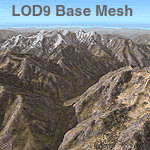
Detailed terrain mesh of the Southcentral Himalayan Ranges, N26-32 E82-90. The files in this package are based on Shuttle Radar (SRTM) Version 2 data but with many of the void areas, especially the most significant sections, filled with elevation data generated from topographic maps by Jonathan de Ferranti. While Jonathan's work is unrelated to flight simulation he kindly gave me permission to compile his data for use in FS. The result is a wonderful improvement in detail and accuracy over any existing mesh file, freeware or commercial, based on SRTM or DTED data alone.
Due to the large area of the Himalayas I've compiled the source data as two separate series: the "Himalayan Peaks" series covers prominent mountains and ranges in higher detail and locally overrides any existing LOD9 terrain mesh. In addition, a LOD9 "base mesh" series, with LOD8 and LOD7 "buffer" mesh files, covering the entire Himalayas, is meant for those who do not yet have an add-on terrain mesh of these beautiful mountains.
| Filename: | fs_him_b2.zip |
| License: | Freeware, limited distribution |
| Added: | 29th May 2010, 09:05:56 |
| Downloads: | 9,426 |
| Author: | Holger Sandmann, Jonathan de Ferranti |
| Size: | 90.25 MB |
© 2001-2025 AVSIM Online
All Rights Reserved