
Where Flight Simulation Enthusiasts Gather from Around the World!
AVSIM Library - Search Results

| Category: Flight Simulator X - Aircraft Repaints, Textures and Modifications | |
| Alaska Airlines "Fly and Ski" Boeing 737-800 |

|
Images related to this file:
File Description:
Repaint of PMDG's 737-800 WL in Alaska Airlines' Fly and Ski scheme. TExtures only for the PMDG B737-800 NGX.
| Filename: | Alaska_Airlines_Fly_and_Ski_Boeing_737800.zip |
| License: | Freeware |
| Added: | 28th November 2015, 14:08:37 |
| Downloads: | 1,172 |
| Author: | Alec Liberman |
| Size: | 22.48 MB |
| Category: Flight Simulator X - Aircraft Repaints, Textures and Modifications | |
| Alaska Airlines C-46 Commando |
|
File Description:
C-46 Commando of Alaska Airlines circa 1955ish for the Tom Gibson/Libardo Guzman C-46 Commando vers 2 in FSX.
| Filename: | Alaska_Airlines_C46_Commando.zip |
| License: | Freeware, limited distribution |
| Added: | 11th December 2016, 21:57:26 |
| Downloads: | 156 |
| Author: | Willy McCoy |
| Size: | 14.46 MB |
| Category: Flight Simulator 2004 - AI Aircraft | |
| Island Air Service. Britten-Norman BN-2A/B Islander |
|
Images related to this file:
File Description:

Island Air Service, Kodiak, Alaska. Britten-Norman BN-2A/B Islander. Two paint variants. Textures only. Model by Henry Tomkiewicz required.
| Filename: | Island_Air_Service_BrittenNorman_BN2AB_Islander.zip |
| License: | Freeware |
| Added: | 16th May 2010, 23:40:39 |
| Downloads: | 494 |
| Author: | Stefan Schroeder |
| Size: | 200.77 KB |
| Category: Flight Simulator 2004 - AI Flight Plans | |
| ConocoPhillips Winter 2010-2011 |
|
Images related to this file:
File Description:

ConocoPhillips is Alaska's largest oil and gas producer with significant ownership interests in two of North America's largest oil fields located on Alaska's North Slope & Kuparuk, which ConocoPhillips Alaska operates, and Prudhoe Bay. The company also has a significant operating interest in the Alpine field on the Western North Slope, as well as adjacent Alpine satellite fields. ConocoPhillips Alaska headquarters are located in Anchorage. Includes the Alaska fleet as well as the ERJ135LR that shuttles between Bartlesville, Oklahoma, and Houston Bush twice per day. Flights taken from FlightAware for the week of February 27- March 5, 2011.
| Filename: | ConocoPhillips_Winter_20102011.zip |
| License: | Freeware |
| Added: | 14th March 2011, 08:00:28 |
| Downloads: | 728 |
| Author: | Steve Lewis |
| Size: | 4.21 KB |
| Category: Flight Simulator X - Aircraft Repaints, Textures and Modifications | |
| FS2004/FSX Alaska Boeing 787-9 "New long haul" livery |
|
Images related to this file:
File Description:
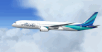
FS2004/FSX Alaska Boeing 787-9, registration N781HA, Alaska's "new" long haul livery painted on N781HA. Alaska's new livery repainted on the Tenkuu Developers Studio (TDS) B787-9 GE paint kit. The textures are currently based on the "preliminary images" and may change once out of the paint shop. The detailed textures include full night lighting, custom passenger entry, custom cargo containers & catering trucks. Textures ONLY. Add file to your existing TDS 787-9 GE model. For support of the model please TDS 787 page, https://www.facebook.com/groups/TDS.SkySpirit.B787 Repaint by Phillip Hughes.
| Filename: | FS2004FSX_Alaska_Boeing_7879_New_long_haul_livery.zip |
| License: | Freeware |
| Added: | 21st December 2025, 16:19:30 |
| Downloads: | 183 |
| Author: | Phillip Hughes |
| Size: | 12.46 MB |
| Category: Flight Simulator X - AI Aircraft | |
| Alaskan AI Package version 5 |
|
File Description:
This package will add AI aircraft to the state of Alaska, USA. It is currently in version 5 (all inclusive), including:
- Alaska Central Express
- Lynden Air Cargo
- Shared Services Aviation
- Carlin Air
- Pirate Airworks
- Seawind Aviation
- Island Wings Aviation
- Alaska Air Fuel
- Beluga air
- Division of Forestry
Future versions will include more airlines. Aircraft, paint schemes and flight-plans are all included. See the credits in the readme for a list of people who's work is included (with permission) in this package. This package is only compatible with FSX.
| Filename: | Alaskan_AI_Package_version_5.zip |
| License: | Freeware, limited distribution |
| Added: | 20th November 2014, 13:36:22 |
| Downloads: | 4,046 |
| Author: | Adam Begg (including permitted work of others) |
| Size: | 18.59 MB |
| Category: Flight Simulator 2004 - Scenery | |
| Backcountry airfields for 19m terrain mesh in Idaho USA |
|
Images related to this file:
File Description:
These four backcountry fields are for use with the FSGenesis 19m mesh of Idaho, and are Big Creek, Johnson Creek, Dixie, and Sulphur Creek Ranch. They have been revised to fit and almost certainly do not work without the 19m mesh; a quick comparison with Big Creek before and after demonstrates the difference. I also have Ultimate Terrain installed. The three ingredients of terrain mesh, UT main roads, and UT streams, along with their individual margins of error, very often create conficts of space that make a grass runway impossible to site with it's correct length. Given the choice of turning off roads or streams (the terrain mesh cannot be turned off, obviously) I chose streams; the roads are less obviously incorrect, plus it matters not if roads go uphill while a climbing stream is to be avoided. On that basis the original series is reissued here for use with the 19m terrain mesh, on the presumption that you have already downloaded the original series. There are no textures or AI included as they remain the same as the originals, and the new scenery bgl's replace the originals to get the runways and grass etc in the right positions. There will be follow-on fields that are new, and all of the new ones will be only for the 19m mesh.
| Filename: | Backcountry_airfields_for_19m_terrain_mesh_in_Idah.zip |
| License: | Freeware, limited distribution |
| Added: | 29th May 2017, 04:19:43 |
| Downloads: | 125 |
| Author: | Roger Wensley |
| Size: | 2.22 MB |
| Category: Orbiter - Spaceships | |
| Ariane MEP 1.0.1 |
|
File Description:
This is a bugfix for the Prevous version. you do not need the prevoius version. I just included the mesh with the package.
| Filename: | Ariane_MEP_101.zip |
| License: | Freeware |
| Added: | 3rd January 2004, 03:07:31 |
| Downloads: | 823 |
| Author: | Zachary Grillo |
| Size: | 482.16 KB |
| Category: Fly! II - Scenery | |
| Ferlach Airfield V1.0b |
|
File Description:
Ferlach is a small Austrian airfield south of Klagenfurt. For use with my Austria east mesh only.
Now with the missing DEX-files.
| Filename: | Ferlach_Airfield_V10b.zip |
| License: | Freeware |
| Added: | 20th November 2006, 11:16:09 |
| Downloads: | 92 |
| Author: | Kraft Harald |
| Size: | 2.92 MB |
| Category: Flight Simulator X - Scenery | |
| EGFE - Haverfordwest |
|
File Description:
Haverfordwest Airfield, Penmbrokeshire, Wales. Blended to fit Horizon GenX Scenery and Mesh. No Cliff effect. Scenery is mixture of default and Runway12 Libraries.
| Filename: | EGFE__Haverfordwest.zip |
| License: | Freeware, limited distribution |
| Added: | 10th October 2007, 12:42:14 |
| Downloads: | 1,043 |
| Author: | Tony Meredith |
| Size: | 278.2 KB |


© 2001-2026 AVSIM Online
All Rights Reserved
Privacy Policy |