
Where Flight Simulation Enthusiasts Gather from Around the World!
AVSIM Library - Search Results

| Category: Microsoft Flight Simulator (2020) - Aircraft Repaints, Textures and Modifications | |
| New! Cessna 185F N180MB |

|
Images related to this file:
File Description:
AIRFRAME & TIMES
Total Time 3,776.3 hours
Engine Continental IO-550-D — 290.1 hours since new (installed 2024)
Propeller McCauley 3-blade — manufactured 2016
Annual Current
Logs Complete
Damage History Main gear: Struck rocks and scrub brake line replaced, 2006 repaired. Bird strike: Tail fin. Northern Goshawk, dent, no repair, 2007. Floats damaged punctured. Kuskokwim river, 2012 discarded.
EQUIPMENT
Ski’s, Tundra tires included
Wing X wingtip extensions
Monarch fuel fillers and caps
RMD wing tip lights
NOTES
Low-time IO-550 on a solid 185F airframe and ready for Alaska work.
New Propeller spinner installed primed, New oil door hinge and hardware installed primed. New tires. All specs subject to verification on inspection.
Currently standard tires installed.
| Filename: | Cessna_185F_N180MB.zip |
| License: | Freeware, limited distribution |
| Added: | 13th October 2026, 21:23:06 |
| Downloads: | 3 |
| Author: | Don Elliott |
| Size: | 6.96 MB |
| Category: Flight Simulator X - Aircraft Repaints, Textures and Modifications | |
| McDonnell Douglas DC-10 - air charter airlines 4-pack |
|
Images related to this file:
File Description:
FSX McDonnell Douglas DC-10-15 air charter 4-pack repaint textures for the
freeware Thomas Ruth/Eric Cantu McDonnell Douglas DC-10 series. I use the
updated for FSX with VC models multi-pack (tomdc10.zip), which includes the -10,
-15, -30, and -40 models. With plenty of life left before heading to the boneyard,
these DC-10's are pressed into service with four small time mom and pop charter
operators... Charterlink America, Holiday Alaska Charters, Honolulu Aero Charter,
and Tropicanada Island Tours. These repaints work with any of the four Ruth/Cantu
model variations, I just chose the -15 as my painting platform. Also includes
engine exhaust smoke coordinates for FSX which you can add to your various model's
"aircraft.cfg" files if you wish. Screenshots enclosed. Easy installation.
Repaints by Tom Tiedman.
| Filename: | McDonnell_Douglas_DC10__air_charter_airlines_4pack.zip |
| License: | Freeware |
| Added: | 24th August 2013, 10:57:35 |
| Downloads: | 273 |
| Author: | Thomas Ruth, Erick Cantu, Tom Tiedman |
| Size: | 56.34 MB |
| Category: Flight Simulator 2004 - Scenery | |
| Brevoort CWOB and BAF-3 radar plus Cartwright LAB-6 radar Canada |
|
Images related to this file:
File Description:
Brevoort airstrip and the BAF-3 radar it serves is on Brevoort Island, off one of the southeastern tips of Baffin Island and 140 miles east of Iqaluit. This scenery includes the BAF-3 buildings on the hilltop and those on the airstrip below, plus the roads connecting them and down to the beach landing area on the rocky coast. This scenery is made for the FSGenesis 76m terrain mesh for northern Canada, and there will be a repost of all my northern Canada airfields to suit this; I cannot think now why I never installed this mesh before. The AI reflects the use of civil airlines for resupply and transportation of personnel. Given the terrain the wind should be from the north so that ai lands using the 02 runway. Landing from the north will involve a terrain clash while take off towards the north will not as the climb out clears the hilltop. The video shows the 600 foot cliff at the runway threshold and an Air Tindi plane on the apron. Cartwright CYCA is on the Labrador coast and has been posted by Flight Ontario as part of their Goose Bay and Labrador Regional Airports sceneries. The nearby LAB-6 radar site is included here, connected to CYCA by an extended road. The site uses the same buildings as Brevoort and Saglek (posted recently) and although I have included them here as separate sceneries the contents can be placed in the same folders as Saglek with a saving in duplicated textures. The textures here are more accurate than Saglek so say yes to over-write; a downloader with personal experience of Brevoort noted that in reality they are lighter.
| Filename: | Brevoort_CWOB_and_BAF3_radar_plus_Cartwright_LAB6_.zip |
| License: | Freeware, limited distribution |
| Added: | 20th August 2017, 15:46:36 |
| Downloads: | 177 |
| Author: | Roger Wensley |
| Size: | 4.37 MB |
| Category: Prepar3D V5 - Scenery | |
| Victoria Falls Bridge – Southern Africa |
|
Images related to this file:
File Description:
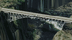
The Victoria falls bridge is located just below the spectacular Victoria water falls in the Zambezi River linking Zimbabwe and Zambia. The steel bridge was completed in 1905 and spans the 200m wide and 128 m wide gorge just below the 1708 m wide falls. This area seems to be a bit neglected in the sim despite the latest add-ons so I decided to spruce it up a little by adding a spray effect for the falls and making some changes to the surface to try to show the waterfall.
I used the P3D 5.3 SDK and tested it in P3D V5.3 using the ORBX Africa LC and Pilots NG2020 mesh products The falls and bridge is 10nm to the north of FVFA in Zimbabwe or 165 degrees from FLNH if you want to approach it from the Zambia side.
| Filename: | Victoria_Falls_Bridge___Southern_Africa.zip |
| License: | Freeware |
| Added: | 1st February 2022, 01:06:27 |
| Downloads: | 66 |
| Author: | Johan Pienaar |
| Size: | 12.78 MB |
| Category: X-Plane - Scenery | |
| WXAR Susi Air Armopa Road Airstrip v1.0.0 |
|
Images related to this file:
File Description:

This is an X-Plane 11 scenery for Armopa Road Airstrip (WXAR) in the Armopa, Papua, Indonesia. This is a fictitious airfield, located in an active road. This fictitious airfield may serve as a road challenge while flying the airstrips in Papua, as one of the destinations for "PT ASI Pujiastuti Aviation", operating as Susi Air, an Indonesia airlines established in late 2004 by Mrs. Susi Pudjiastuti. This scenery was tested and is operational (as of January 19, 2017) in "X-Plane 11 Public Beta #6 64 bit", Windows 10 Home. It was also tested and is partially operational (as of January 19, 2017) in "X-Plane 10.51 64 bit", Windows 10 Home. The issue with XP10 is the mesh again: there is no road in XP10, and no traffic, while the road and the traffic is there in XP11.
| Filename: | WXAR_Susi_Air_Armopa_Road_Airstrip_v100.zip |
| License: | Freeware |
| Added: | 20th January 2017, 07:11:16 |
| Downloads: | 53 |
| Author: | Rui Mesquita |
| Size: | 2.06 MB |
| Category: Flight Simulator 2004 - Scenery | |
| Modified SRTM Relief 76 m for Czech Republic |
|
File Description:
This Czech Republic terrain mesh 76 m (LOD9) is made from the 3arc-sec SRTM. Small voids in the source data were filled by the interpolation. Both the primary processing of the 3arc-sec data and the rendering of the terrain in the FS cause flattening and simplifying of the real shape of the terrain. This phenomenon was partially compensated by the sharpening of the source data. Made by the programs Surfer (Golden Software) and MS Terrain SDK 2000 and 2002. The relief covers the area N51.1523 E011.9531 to N48.5156 E018.9844 in the boundaries of the LOD9 quadrants. This scenery contains only the elevation data. The other elements of the basic terrain as the landclass, locally used airborne photos, vector roads, rivers and lakes are available in different sceneries by other authors and they are continuously developed.
| Filename: | Modified_SRTM_Relief_76_m_for_Czech_Republic.zip |
| License: | Freeware |
| Added: | 22nd December 2003, 21:25:07 |
| Downloads: | 6,723 |
| Author: | Vladimir Stoje |
| Size: | 20.81 MB |
| Category: Flight Simulator 2004 - Scenery | |
| EPGD 2008 - Gdansk Lech Walesa Airport, Poland |
|
Images related to this file:
File Description:

Gdansk Lech Walesa Airport (EPGD) is an international airport located in Gdansk, Poland, not far from the city centers of the Tricity metropolitan area: Gdansk (6.25 miles/10 km), Sopot (6.25 miles/10 km) and Gdynia (14.4 miles/23 km). The airport is named after Lech Walesa, the former Polish president. On the outside wall of the terminal building one can see the logo of the airport, which is Lech Walesa's actual signature, a stylized "W".
EPGD 2008 is the first Polish scenery in this quality. Main features of the scenery are:
-Airport ground high resolution textures - (five seasons + night textures);
-Highly detailed 3D objects, all photo textured;
-Animation vehicles ground services;
-Detailed autogen and photorealistic trees;
-Detail mesh.
For more details please look at the README file attached to the scenery file.
| Filename: | EPGD_2008__Gdansk_Lech_Walesa_Airport_Poland.zip |
| License: | Freeware |
| Added: | 18th May 2010, 10:37:46 |
| Downloads: | 25,753 |
| Author: | Kuba Paczek |
| Size: | 24.06 MB |
| Category: Flight Simulator 2004 - Scenery | |
| Modified SRTM relief 76 m for Slovakia |
|
File Description:
This Slovak terrain mesh 76 m (LOD9) is made from the 3arc-sec SRTM. The voids in the source data were filled by the interpolation. Both the primary processing of the 3arc-sec data and the rendering of the terrain in the FS cause flattening and simplifying of the real shape of the terrain. This phenomenon was partially compensated by the sharpening of the source data.
Made by the programs Surfer (Golden Software) and MS Terrain SDK 2000 and 2002. The relief covers the area N49.9219 E016.1719 to N47.4609 E022.9687 in the boundaries of the LOD9 quadrants. This scenery contains only the elevation data. The other elements of the basic terrain as the landclass, locally used airborne photos, vector roads, rivers and lakes are available in different sceneries by other authors and they are continuously developed.
| Filename: | Modified_SRTM_relief_76_m_for_Slovakia.zip |
| License: | Freeware, limited distribution |
| Added: | 28th May 2010, 19:40:13 |
| Downloads: | 4,612 |
| Author: | Vladimir Stoje |
| Size: | 19.36 MB |
| Category: Flight Simulator 2004 - Scenery | |
| KCRW - Charleston-Yeager 2014 |
|
Images related to this file:
File Description:
Yeager Airport KCRW in Charleston, West Virginia, is a mid-size airport surrounded by beautiful terrain (see the section on Optional Mesh). The terminal can easily accommodate 737 class airliners as well as commuter turboprops, and there are GA and West Virginia National Guard ramps. This scenery reflects the current single runway configuration, the former second runway having been converted into taxiway C. It is a complete rebuild with all custom buildings and some photo ground textures. I have also redone the instrument approaches to match the current real ones, and they will automatically be listed and displayed on your GPS. Instrument Approach Plates are included.
This work is entirely my own, but I would like to thank Brandon DePalo for his very well done earlier version of KCRW. Without that, I would not have known about this airport.
| Filename: | KCRW__CharlestonYeager_2014.zip |
| License: | Freeware |
| Added: | 26th April 2014, 07:05:30 |
| Downloads: | 650 |
| Author: | Sidney Schwartz |
| Size: | 7.29 MB |
| Category: Prepar3D V1-4 - Original Aircraft | |
| Random Flight Database 2.3.0 |
|
File Description:
Random Flight Database is a simple and easy to use application.
It will allow you to randomly choose a flight according to your criteria.
A default database is already included, but also the possibility for each user to create his own database.
But it's not all, you can also extract the flights of the day for an airport, or extract flights on a full week.
Windows Only
2.3.0
Replace winter by summer 2019 :
Air Do
Alaska Airlines
All Nippon Airways
Amakusa Airlines
ANA Cargo
ANA Wings
FlyOne
Ibex Airlines
Peach Aviation
PenAir
Skymark Airlines
Solaseed Air
Starflyer
TAP Air Portugal
TAP Express
TUI fly Belgium
Vanilla Air
Wamos Air
Install : Execute .exe
Contact [email protected]
https://mikoulprostgrandprix.wixsite.com/randomflightdatabase
Other install : execute the shortcut "Check Update Random Flight Database"
Do not hesitate to send me bugs, or proposals. Thanks
| Filename: | Random_Flight_Database_230.zip |
| License: | Freeware |
| Added: | 27th September 2019, 17:07:27 |
| Downloads: | 96 |
| Author: | mikoulprostgrandprix |
| Size: | 78.36 MB |


© 2001-2026 AVSIM Online
All Rights Reserved
Privacy Policy |