
Where Flight Simulation Enthusiasts Gather from Around the World!
AVSIM Library - Search Results

| Category: Flight Simulator 2004 - Scenery | |
| St Michael Island in Alaska-St Michael 5S8 and Stebbins WBB |

|
Images related to this file:
File Description:
St Michael Island is 50 miles southwest of Unalakleet, an island that in fact appears to be a cape and a firmly attached piece of the mainland. On the island there are two villages, St Michael on the northeast corner and Stebbins on the northwest. St Michael has a new airfield that is west of the village by around a mile or so, with a gravel runway 4,000 feet long. The old and now closed airport was known as SMK, and is now readily identifiable by the new red-roofed school building that occupies the centre of the runway. The new airfield now has an icao code of PAMK, but FS9 does not readily accept icao code changes so we are stuck with the original code it was given, 5S8. The SMK icao of the old airport will still show on your gps as if I deleted it the runway would also have to be deleted, and a substitute and unsatisfactory gravel apron made to impersonate a runway. Stebbins is 5 miles west of St Michael and next to the shore, a smaller village than St Michael with around 250 inhabitants. The airfield is at the southern end of the village and has a gravel runway that is 3,000 feet long. The icao code is WBB. There is no AI included here as it was already included in the post of Shaktoolik. There is a correction here for Shaktoolik, which I now find should have had a blue garage, not a red one; I wrongly named a photo. A note here about my scenery making. This is post number 501 and there will not be many more to follow this as I am almost at the end of the photos I took or found for scenery purposes. There is a limit to what can be located online and I have already been making use of the little there is; eg Unalakleet. So, if you are near an airfield (preferably Canadian or Alaskan) and have a camera..... Let me know.
| Filename: | St_Michael_Island_in_AlaskaSt_Michael_5S8_and_Steb.zip |
| License: | Freeware, limited distribution |
| Added: | 1st August 2019, 16:45:58 |
| Downloads: | 96 |
| Author: | Roger Wensley |
| Size: | 3.88 MB |
| Category: Flight Simulator 2004 - Scenery | |
| Bethel area airfields in southwest Alaska close to the Yukon River |
|
Images related to this file:
File Description:
This presumes you have already installed my post of Bethel PABE. In the Yukon River area of Alaska there are a lot of small villages close together, which is unusual for Alaska. Almost all of them are on the coast or a river bank, and the local economies depend on fishing. Some are larger than others and have a fish processing plant, such as in Emmonak. This is the largest such plant and it exports prepared fish by cargo planes which fly in on a daily basis, using an extended runway. This post includes airfields to the south and west of PABE, 17 of them; some of them already included and now modified. There will be more airfields to the north and northwest of Bethel in a future post. There are revisions to Bethel to include parking spaces for Yute Air (newly included here) and extra spaces for Ryan Air. Both of these flew Cessna 205 planes into the smaller village strips from Bethel (past tense as Yute Air recently went bankrupt). The northwest area is served both from Bethel and also from St Mary's PASM, which is in the northwest and at a more economical range to the local airfields (100 miles closer than Bethel). These smaller airfields have few airfield buildings or any other creature comforts; featuring heavily are a new standard blue garage building (sometimes not yet installed) and a small and old terminal shed (that has sometimes collapsed and been removed). Go to "http://vfrmap.com/" for free vfr maps of the area, There is a pic of the local chart area included here. The screenshots are a random sample. Kipnuk PAKI is the one that appears to have a second and long grass runway; what it actually has is the ground prepared for a new and long gravel runway but which hasn't been started yet as it has taken 10 years just to prepare the ground. I have no idea why.
| Filename: | Bethel_area_airfields_in_southwest_Alaska_close_to.zip |
| License: | Freeware, limited distribution |
| Added: | 16th April 2019, 22:47:47 |
| Downloads: | 156 |
| Author: | Roger Wensley |
| Size: | 5.93 MB |
| Category: Flight Simulator X - Aircraft Repaints, Textures and Modifications | |
| GOL Airlines " Smile ", Transavia, Alaska Airlines - Boeing 737-800 (3 Pack) |
|
Images related to this file:
File Description:
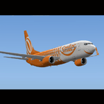
GOL Airlines " SMILE ", TRANSAVIA, ALASKA AIRLINE " Employee Powered " texture set for the TDS Boeing 737-800 (not included, must download base package). Model developed by Tenkuu Developers Studio, features high resolution textures, dynamic flexing wings, nose gear steering, rudder lock, ground spoilers, low speed aileron locks at high speed, fully animated control surfaces, fully independent suspension, trim animation, opening passenger doors, rolling wheels, animated thrust reversers with reverser block doors, detailed textures, full night lighting, ground service vehicles and more. Model design by Hiroshi Igami. Flight dynamics design by Nick Wilkinson, with assistance from David Biggar. Master textures and paint kit by Kyle Schurb. Painted by Triadi Sudarmawan for the great TDS model. Also works with FS2004.
| Filename: | GOL_Airlines__Smile__Transavia_Alaska_Airlines__Bo.zip |
| License: | Freeware |
| Added: | 23rd February 2014, 08:55:14 |
| Downloads: | 692 |
| Author: | Triadi Sudarmawan |
| Size: | 12.45 MB |
| Category: Flight Simulator X - Scenery | |
| USCG Air Station Kodiak Alaska PADQ Scenery Package with AI Aircraft |
|
Images related to this file:
File Description:
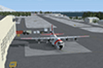
Thanks to Airport Design Editor(ADE), Military AI Works (MAIW) scenery and aircraft, along with AI Flight Planner3 (AIFP3), I did my best to re-create USCG Air Station Kodiak for FSX. Creating this airport scenery was my first BIG (for me) project in ADE, but thanks to MAIW and their Global Scenery Library Objects, I think I've succeed in re-creating the airbase. You'll need to go to MAIW's website and download the "Global Scenery" package for any of this to work for you, so I've copied that website link below (in STEP 1). I also painted Kodiak markings onto all the MAIW AI Aircraft for added realism.
And just for fun, I placed a USCG Cutter and a "fishing boat in distress" (complete with green smoke) out in the harbor as a "Practice Recue Scenario". The Cutter has a "hard deck" to land on and I've also illuminated both it and the Fishing boat for DUSK and NIGHT practice.
| Filename: | USCG_Air_Station_Kodiak_Alaska_PADQ_Scenery_Packag.zip |
| License: | Freeware |
| Added: | 31st January 2021, 06:43:03 |
| Downloads: | 1,019 |
| Author: | Daniel W Gregory |
| Size: | 25.65 MB |
| Category: Flight Simulator 2004 - Scenery | |
| 28A - Goose Creek Airport |
|
Images related to this file:
File Description:
FS2004 Scenery--Goose Creek Airport (28A), is a small GA airfield located near Indian-Trail, North Carolina (NC), USA. It is home to Pressley Aviation Inc., a popular flight-training school. This scenery package uses common objects from the Rwy12 and EZ-Scenery libraries (not included) and these are required for correct scenery display. A good high-quality terrain mesh from FSGenesis or equivalent supplier is also recommended for best results. It will work with the default FS2004 terrain engine as well.
| Filename: | 28A__Goose_Creek_Airport.zip |
| License: | Freeware |
| Added: | 30th October 2011, 14:42:17 |
| Downloads: | 738 |
| Author: | Glenn Mullis |
| Size: | 3.81 MB |
| Category: Flight Simulator 2002 - Scenery | |
| Olympic National Park Bush Scenery |
|
File Description:
Ultra-challenging bush scenery set in Washington state's Olympic National Park, just west of Seattle. Consists mainly of small mountain lakes to test the skills of floatplane pilots, but there is also a special sloping airstrip for regular planes. There are 2 groups of scenery included: one on Mount Olympus itself, and the other just a few miles North of Emma Field in the southeast corner of the Park. Requires Steve Greenwood's Olympic National Park/Emma Field mesh (fst-30m10-wa-ef.zip).
| Filename: | Olympic_National_Park_Bush_Scenery.zip |
| License: | Freeware |
| Added: | 28th January 2003, 17:26:26 |
| Downloads: | 1,286 |
| Author: | James Belk |
| Size: | 3.04 MB |
| Category: Flight Simulator 2002 - Scenery | |
| Fish Lake Fix |
|
File Description:
This is a fix for the FS2002 default scenery that surrounds the airport at fish lake USFS in Idaho. It also works with Denney's mesh (originally created for FS2000, but works fine in FS2002). The default scenery has fish lake that is situated at the approach end of of runway 21 elevated about fifty feet above the elevation of the airport. This scenery .bgl flattens the lake area to make the approach to runway 21 as it is at the real airport.
| Filename: | Fish_Lake_Fix.zip |
| License: | Freeware |
| Added: | 22nd May 2003, 21:18:32 |
| Downloads: | 362 |
| Author: | Tim Slanczka |
| Size: | 209.95 KB |
| Category: Flight Simulator 2004 - Scenery | |
| New Airport for Canadian Mountain Parks Pack |
|
File Description:
FS2004 Scenery - This file adds 1 new airport to Canadian Mountain Parks Pack (cmpcanmtpks_v1.zip available at AVSIM) . Required is: cmpcanmtpks_v1.zip, Holger Sandmann's excellent BC mesh, which was the original reason for these files in the first place, and Lago's FSE demo file. Pack designed for low level visual 30 mile scenic flights. The strip is ficticious, but the names and places are real. There is parking for you to add your own AI traffic as well. One flight included.
| Filename: | New_Airport_for_Canadian_Mountain_Parks_Pack.zip |
| License: | Freeware |
| Added: | 27th April 2004, 17:53:12 |
| Downloads: | 710 |
| Author: | Peter Vibe |
| Size: | 296.49 KB |
| Category: Flight Simulator 2004 - Scenery | |
| Mangalore Airport VOML |
|
File Description:
This scenery models Bajpe Airport, Mangalore (VOML) in Southern India (as seen in 2004). Works best when combined with my "India_76m-Mesh_Part_A" available at the AVSIM library.
Mangalore airport is known for it's infamously short runway that sits on top of a table-top mountain. This is modelled quite accurately in my mesh for Southern India. There have been quite a few near miss incidents in the past 20Yrs. So, if you're flying big tin, don't forget to step on the brakes ;-)
| Filename: | Mangalore_Airport_VOML.zip |
| License: | Freeware |
| Added: | 21st January 2006, 22:36:44 |
| Downloads: | 2,872 |
| Author: | Keith Sebastian |
| Size: | 169.52 KB |
| Category: Flight Simulator 2004 - AI Flight Plans | |
| Abaete Linhas Aereas - Summer |
|
File Description:
These are some ficticious FPs,(only the destinations and days are real, since they do not give any departure times in their site. For the use of the existing freeware repaint abaeti_emb-110.zip (avsim)
AFCAD modifications of the default airports for SBSV,SBLP,SNBR,SNGI,(ficticious) + callsign (ficticious ,but possible).
In order of the airports to be shown correctly, you will need the freeware SRTM Terrain Mesh of South America by Andy Weir (avsim)- Files: sa11.zip, sa14.zip,\ & sa17.zip
| Filename: | Abaete_Linhas_Aereas__Summer.zip |
| License: | Freeware |
| Added: | 1st September 2005, 17:28:24 |
| Downloads: | 618 |
| Author: | John Tsimas |
| Size: | 8 KB |


© 2001-2026 AVSIM Online
All Rights Reserved
Privacy Policy |