
Where Flight Simulation Enthusiasts Gather from Around the World!
AVSIM Library - Search Results

| Category: Flight Simulator 2004 - Scenery | |
| Galena PAGA Runway and Taxiway Lighting in Alaska |

|
Images related to this file:
File Description:
Galena is in Alaska, and this posting adds proper runway lighting to the gravel runway that is used in the winter by light planes on skis, and because of that is not cleared of snow; unfortunately a gravel surface that gets snow covered in winter cannot be replicated in FS9. There are also taxiway lights visible during the day and at night there will be lit taxiway lights. I did not attempt to replicate the complicated main runway lighting which is well covered anyway by FS9. First of all, download and install the Library Objects once and for all from either the Allakaket Lights or Anaktuvuk Lights postings earlier this week. Then put these new bgl's into the existing scenery folder of your previous Galena PAGA installation and say yes to replace the existing bgl's that have the same names. Add the texture folder contents to the existing texture folder as they are required for the red warning lights at the ends of the gravel runway. There will be further retro upgrades to other recent scenery that was posted with temporary lighting. Say thank you to Greg Putz for making the lighting.
| Filename: | Galena_PAGA_Runway_and_Taxiway_Lighting_in_Alaska.zip |
| License: | Freeware, limited distribution |
| Added: | 27th November 2019, 19:14:31 |
| Downloads: | 155 |
| Author: | Roger Wensley |
| Size: | 1011.22 KB |
| Category: Flight Simulator 2004 - Aircraft Repaints, Textures and Modifications | |
| Alaska Airlines, Convair CV-240 VBF CA-18 |
|
Images related to this file:
File Description:
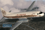
CV-240-0, reg.-id. N51331, cn 76, in colors of 1973, delivered on June 30, 1948 to American Airlines, reg.id N94238, named "Flagship Little Rock", later "Flagship Erie". Served for several operators until bought by Cordova Airlines on June 15, 1965. Cordova Airways was merged with Alaska Airlines on February 1, 1968. Bought by Pacific Nevada Airl. on January 30, 1973. Returned to Alaska Airlines in May 1973. Bought by Byco Air Services on November 30, 1973. Bought by Pacific Airl. on April 9, 1975. Repossessed by Crocker National Bank on January 1976, withdrawn from use and stored at Long Beach, California, finally broken up.
Textures and associated model file included only. Requires cv240VBFca18_basepack_010.ZIP. Original by Greg Pepper & Tom Gibson, upgraded by Georg Hauzenberger (model) and Hans Hermann (textures) Virtual Birds Factory
| Filename: | Alaska_Airlines_Convair_CV240_VBF_CA18.zip |
| License: | Freeware, limited distribution |
| Added: | 8th September 2010, 22:41:28 |
| Downloads: | 807 |
| Author: | Georg Hauzenberger, Hans Hermann |
| Size: | 4.41 MB |
| Category: Flight Simulator 2004 - Scenery | |
| Airports Northern Coast Alaska (PALU, PPIZ, PAWI, AK03) |
|
Images related to this file:
File Description:
The town of Barrow is in the far north of Alaska, and these are coastal villages or radar installations to the west of Barrow, and there will be additions. Cape Lisburne is a gravel runway right next to the coast with radar gear and accomodation buildings close by, and what was called "Top Camp" at the end of a long and steep road to the top of a nearby hill, or mountain. The runway is lit, as are most of them in this area of long dark winter nights. Barrow is 270 miles to the northeast. Point Lay PPIZ used to have a radar installation as well as a village, but the old buildings have now been removed and the gravel runway 05-23 has been lengthened to 5,000 feet to serve the village throughout the year. The population is around 270, living mostly traditionally and with an annual beluga whale hunt. Barrow is 180 miles to the northeast.
Wainwright PAWI, some 80 miles southwest of Barrow and on the coast, has a population of around 570. The PAWI runway is just under 5,000 feet long and like PPIZ is aligned 05-23, lit, and with PAPI on each end. The original runway of some 2,000 feet is still visible next to the apron. Three miles to the southeast there is a third runway, at AK03, serving the Wainwright DEW station. It was decided in 2007 to close the station and to remove the buildings both there and at Point Lay because of subsidence, but everything at Wainwright was still in place in 2009 and beyond. The villages have been "sketched" as opposed to replicated exactly. The texture folder includes the missing car textures for Barrow PABR, and the AI is modified PABR to include passenger flights by Ravn and cargo flights by Northern Air Cargo, plus limited GA. There are no flattened grassed areas at these airfields; they are runways and taxiways and aprons on a bed of gravel on permafrost.
| Filename: | Airports_Northern_Coast_Alaska_PALU_PPIZ_PAWI_AK03.zip |
| License: | Freeware, limited distribution |
| Added: | 16th June 2016, 15:59:24 |
| Downloads: | 364 |
| Author: | Roger Wensley |
| Size: | 10.84 MB |
| Category: Flight Simulator X - Original Aircraft | |
| Alaska Airlines "75th Anniversary Starliner" Boeing 737-800 |
|
Images related to this file:
File Description:

FSX B737-800 Series. Developed by Tenkuu Developers Studio (TDS). Model features high resolution textures, dynamic flexing wings, nose gear steering, rudder lock, ground spoilers, low speed aileron locks at high speed, fully animated control surfaces, fully independent suspension, trim animation, opening passenger doors, rolling wheels, animated thrust reversers with reverser block doors, detailed textures, full night lighting, ground service vehicles and more. Package contains model and all files necessary for immediate flight. Model design by Hiroshi Igami. Flight dynamics design by Nick Wilkinson and David Biggar. Master textures by Kyle Schurb. Alaska Airlines Starliner livery by AJ Nikoley.
This model features scimitar winglets and a special decal on the radome for an accurate representation of the star on the nose. Thanks to Hiroshi Igami compiling this special model!
| Filename: | Alaska_Airlines_75th_Anniversary_Starliner_Boeing_.zip |
| License: | Freeware |
| Added: | 20th September 2015, 22:39:45 |
| Downloads: | 3,157 |
| Author: | TDS | AJ Nikoley |
| Size: | 13.84 MB |
| Category: Flight Simulator X - Scenery | |
| PAED - Elmendorf-Richardson Joint U.S. Base, Alaska Update2.4 |
|
Images related to this file:
File Description:
Joint Base Elmendorf-Richardson (IATA: EDF, ICAO: PAED, FAA LID: EDF) is a United States military facility adjacent
to Anchorage. PAED Elmendorf 2011, modeled after Google Earth images. Replaced some static aircraft with frame friendly ones,
fixed ILS and GPS approaches. Full replacement..
| Filename: | PAED__ElmendorfRichardson_Joint_US_Base_Alaska_Upd.zip |
| License: | Freeware |
| Added: | 4th December 2011, 23:41:43 |
| Downloads: | 2,327 |
| Author: | Timothy T. Marson |
| Size: | 12.62 MB |
| Category: Flight Simulator 2004 - Aircraft Repaints, Textures and Modifications | |
| Alaska Airlines "Refreshed Livery" Boeing 737-900 & -900ER |
|
Images related to this file:
File Description:
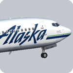
Alaska Airlines was the launch customer of the 737-900, with its first delivery in 2001. Since then the fleet has grown to also include the newer 737-900ER variant, with longer range and ETOPS certification. This package contains three variations of Alaska's 737-900 fleet; N477AS which is a new -900ER with scimitar winglets, N306AS a regular -900 with winglets, and finally N305AS one of the first -900s ever built, but never fitted with winglets. All three feature the new updated Alaska livery. Developed by Tenkuu Developers Studio (TDS). Model features high resolution textures, dynamic flexing wings, nose gear steering, rudder lock, ground spoilers, low speed aileron locks at high speed, fully animated control surfaces, fully independent suspension, trim animation, opening passenger doors, rolling wheels, animated thrust reversers with reverser block doors, detailed textures, full night lighting, ground service vehicles and more. Flight dynamics design by Nick Wilkinson and David Biggar. Master textures and livery by Kyle Schurb. Repaint only included.
| Filename: | Alaska_Airlines_Refreshed_Livery_Boeing_737900__90.zip |
| License: | Freeware |
| Added: | 3rd July 2015, 11:24:21 |
| Downloads: | 778 |
| Author: | Joe Shimmel | Tenkuu Developers Studio |
| Size: | 35.36 MB |
| Category: Flight Simulator 2004 - Aircraft Repaints, Textures and Modifications | |
| Alaska Airlines "More To Love" Boeing 737-900ER |
|
Images related to this file:
File Description:
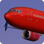
Alaska's special "More To Love" paint scheme was launched to celebrate the merger between Alaska Airlines and Virgin America. Two aircraft feature this livery, an A321NEO, and N493AS, a 737-900ER. The livery was updated was updated in 2019 removing the Virgin America logo as the merger has progressed. Model developed by Tenkuu Developers Studio, features high resolution textures, dynamic flexing wings, nose gear steering, rudder lock, ground spoilers, low speed aileron locks at high speed, fully animated control surfaces, fully independent suspension, trim animation, opening passenger doors, rolling wheels, animated thrust reversers with reverser block doors, detailed textures, full night lighting, ground service vehicles and more. Model design by Hiroshi Igami. Flight dynamics design by Nick Wilkinson, with assistance from David Biggar. Master textures and paint kit by Kyle Schurb. Painted on the great TDS model. Enjoy!
| Filename: | Alaska_Airlines_More_To_Love_Boeing_737900ER.zip |
| License: | Freeware |
| Added: | 21st July 2019, 17:57:04 |
| Downloads: | 451 |
| Author: | Joe Shimmel | Tenkuu Developers Studio |
| Size: | 10.55 MB |
| Category: Flight Simulator 2004 - AI Flight Plans | |
| Alaska Airlines Summer 2018 (incl. former Virgin America!) |
|
Images related to this file:
File Description:

This is part of our flightplans for the Summer 2018 season. The Alpha India Group team aims to provide high quality flightplans for the FS community. Each flightplan has been tested using many resources, and our goal is to make a realistic representation of each airline's route network. Please visit our forum at www.alpha-india.net/forums to read more and sometimes also updates for the plans released.
| Filename: | Alaska_Airlines_Summer_2018_incl_former_Virgin_Ame.zip |
| License: | Freeware, limited distribution |
| Added: | 3rd August 2018, 01:05:22 |
| Downloads: | 1,080 |
| Author: | Christian Hruschka & Alpha India Group |
| Size: | 128.23 KB |
| Category: Flight Simulator 2004 - Flight Plans | |
| Crossing North America Flight Adventures-Package 1 |
|
File Description:
Inspired by Michael Doherty (Difficult & Dangerous Approaches) and David Dossiere (Hopping Round the World) and their flight adventures, I have put together a series of flight plan-adventures where the aircraft used are all available as freeware. A file locator is included with each package so that you can easily find and download the aircraft used. These packages each contain 10 flight adventures and each package begins at the location the previous package ended.
All flightplans are VFR only and are designed so that you can enjoy the outstanding scenery of Alaska, Western Canada, Western and Mountain States of the lower 48, and Mexico.
The adventure, Crossing North America, begins at Pt Hope, Alaska and will conclude in the following months at Cancun, Mexico. The aircraft used are: General Aviation, Vintage, Warbirds, Bush Aircraft, and Propliners. No IFR flightplans or jets!
The flightplans are NOT designed to get you from Alaska to Mexico by the shortest route possible, but are in the spirit of David Dossiere's "Hopping Round the World" adventure flights, in that they take you into as many areas or airports as possible. Looking for some fun, flying low, and enjoying the scenery, then these flight adventures are for you.
| Filename: | Crossing_North_America_Flight_AdventuresPackage_1.zip |
| License: | Freeware |
| Added: | 4th July 2004, 23:01:02 |
| Downloads: | 7,152 |
| Author: | Steve (Bear) Cartwright |
| Size: | 1.03 MB |
| Category: Flight Simulator 2004 - Flight Plans | |
| Crossing North America Flight Adventures-Package 2 |
|
File Description:
Inspired by Michael Doherty (Difficult & Dangerous Approaches) and David Dossiere (Hopping Round the World) and their flight adventures, I have put together a series of flight plan-adventures where the aircraft used are all available as freeware. A file locator is included with each package so that you can easily find and download the aircraft used. These packages each contain 10 flight adventures and each package begins at the location the previous package ended. All flightplans are VFR only and are designed so that you can enjoy the outstanding scenery of Alaska, Western Canada, Western and Mountain States of the lower 48, and Mexico.
The adventure, Crossing North America, begins at Pt Hope, Alaska and will conclude in the following months at Cancun, Mexico. The aircraft used are: General Aviation, Vintage, Warbirds, Bush Aircraft, and Propliners. No IFR flightplans or jets!
The flightplans are NOT designed to get you from Alaska to Mexico by the shortest route possible, but are in the spirit of David Dossiere's "Hopping Round the World" adventure flights, in that they take you into as many areas or airports as possible. Looking for some fun, flying low, and enjoying the scenery, then these flight adventures are for you.
| Filename: | Crossing_North_America_Flight_AdventuresPackage_2.zip |
| License: | Freeware |
| Added: | 4th July 2004, 23:01:15 |
| Downloads: | 5,326 |
| Author: | Steve (Bear) Cartwright |
| Size: | 1.2 MB |


© 2001-2026 AVSIM Online
All Rights Reserved
Privacy Policy |