
Where Flight Simulation Enthusiasts Gather from Around the World!
AVSIM Library - Search Results

| Category: Prepar3D V1-4 - Scenery | |
| Bloukrans and Storms River (Paul Sauer) bridges – South Africa |

|
Images related to this file:
File Description:
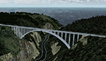
The Bloukrans and Paul Sauer (over the Storms river) bridges are on the N2 highway between Plettenberg Bay and Port Elizabeth on the scenic garden route in the Eastern Cape, South Africa. I made the custom scenery to try some Blender techniques using the P3D 4.5 SDK and tested it in P3D V5 using the ORBX Africa LC and Pilots NG2020 mesh products (I included a fix for the default V5 mesh). You will find the world's highest commercial bungee jump from the Bloukrans bridge, 216m above the river below. Take off from FAPG and fly a heading of 95 degrees for 32 km to get to the Bloukrans bridge (just off the coast). Follow the highway further east for another 26 km to get to the 120m high Paul Sauer bridge, where I included some additional eye candy.
| Filename: | Bloukrans_and_Storms_River_Paul_Sauer_bridges__Sou.zip |
| License: | Freeware |
| Added: | 14th July 2020, 19:15:53 |
| Downloads: | 179 |
| Author: | Johan Pienaar |
| Size: | 26.95 MB |
| Category: Flight Simulator 2004 - Aircraft Repaints, Textures and Modifications | |
| ATR 42-300 "USCG" |
|
Images related to this file:
File Description:
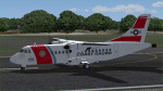
This is a repaint of the great ISDT ATR 42-300 in the real world livery of the United States Coast Gaurd (USCG)for FS9. I realise that the USCG NEVER flew ATR's, but I couldn't resist the temptation tof seeing their livery on such a great plane. This is a complete package and includes the zip file for the already installed panel by A. Bucoli. The plane has been tested in FS9 ONLY. All livery textures are in 32 bit and have been hand painted, other than the USCG Logo. Installation of the Panel is included in the Panel Zip file. Installation of the plane is in the ReadMe file along with Distribution Limitations and contact details for myself. Should you have any problems with this plackage, please don't hestitate to contact me as soon as possible.
| Filename: | ATR_42300_USCG.zip |
| License: | Freeware, limited distribution |
| Added: | 24th October 2010, 07:10:12 |
| Downloads: | 698 |
| Author: | Tony Cannon and ISDT |
| Size: | 22.99 MB |
| Category: Flight Simulator 2004 - Aircraft Repaints, Textures and Modifications | |
| US Airways Airbus A321 New Colors |
|
Images related to this file:
File Description:

Over the past two years US Airways has accepted delivery of several Airbus A321s. Most are west based with IAE engines, but a few were delivered with CFM engines to be based on the east coast. This package contains the new colors livery for both CFM and IAE variants, with registrations N196UW and N519UW, which in real life were delivered together on the same day. These deliveries mark that US Airways has the largest fleet of A321s in the world. This is my 4th remake of this repaint, and by far the best, redone from the ground up with accurate and high-quality handpainted textures that were lacking in my previous releases. If you have one of my old version you will see a huge difference. Painted on the great IFDG model, and as always, enjoy!
| Filename: | US_Airways_Airbus_A321_New_Colors.zip |
| License: | Freeware |
| Added: | 28th December 2009, 20:13:41 |
| Downloads: | 911 |
| Author: | Joe Shimmel and IFDG |
| Size: | 7.14 MB |
| Category: Flight Simulator 2004 - Scenery | |
| VFR of Lario, Area D2 - Como lake, Italy |
|
Images related to this file:
File Description:
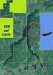
This is the seventh scenery of the "VFR of Lario" project, made with photorealistic terrain and some 3D GMax realistic objects. This scenery covers approximately an area of 7.5x6 kmt, from
north of Bellano (NW) to Casargo (NE), and from Fiumelatte (SW) to Cortenova (SE) and includes the NLC piers of Varenna and Bellano; it includes several dedicated buildings as Vezio castle (Perledo), villa Monastero, S.Giorgio church, marina, piers, hotel Olivedo, and some villas (Varenna), Tommaso Grossi square with pier and light fountain, S.Nazaro-Celso and S.Rocco-Sebastiano churches, Cantoni old cotton mill, group of houses by the lake (Bellano). There are also included four viaducts between the tunnels of the freeway 36, with moted traffic. Hydrofoil G. Marconi at Bellano pier together with other minor boats and docks alongside the lake coast; a moted traffic of motorboats is placed between Varenna's piers.
| Filename: | VFR_of_Lario_Area_D2__Como_lake_Italy.zip |
| License: | Freeware |
| Added: | 23rd July 2012, 15:45:14 |
| Downloads: | 1,259 |
| Author: | Aldo Della Vedova, Daniele Lanfranchi, Gian Mario Verga |
| Size: | 17.95 MB |
| Category: Flight Simulator 2004 - Scenery | |
| FoxPine AirPark, New Zealand. NZFP. |
|
File Description:
Welcome to FoxPine Airpark ,NZFP.
FoxPine AirPark is situated by the small provincial town of Foxton on the South West coast of New Zealand’s North Island.
This Private Airfield set in park-like grounds is sited on a broad coastal plain of mixed farming and forestry bounded by sweeping beaches,
a meandering river, and off to the East, rugged bush-clad ranges, all great places to fly.
FoxPine is also where the "Jabiru" light aircraft is assembled, sold and serviced.
This scenery contains a bonus custom AI package, comprising of seven Jabiru-2's, a Cessna 172, and a Maule M6, and a traffic file for the aircraft. (AI Aircraft are complete with all files).
The AI aircraft, and the traffic file are fully compatible with GNZLAP traffic. Scenery requires some EZ Scenery Object Sets (see INSTALL instructions for details).
| Filename: | FoxPine_AirPark_New_Zealand__NZFP.zip |
| License: | Freeware, limited distribution |
| Added: | 14th August 2008, 21:27:16 |
| Downloads: | 927 |
| Author: | Lawrie Roache |
| Size: | 5.98 MB |
| Category: Flight Simulator 2004 - Scenery | |
| Matheson Point CWMP in Nunavut, Canada |
|
Images related to this file:
File Description:
This was a DEW line I Station on the southeast shore of King William Island; the island is around 70 miles square and Gjoa Haven is also on the southeast corner, 20 miles to the south. The station was closed in 1963 and has now been totally dismantled and removed except for a fallen 300 feet communications tower. The runway is still there (mostly) and is around 3,360 feet of gravel 120' wide, aligned 146T/326T. There are no lights, signage, or windsock, or any building remaining. All of these DEW line stations are not particularly impressive or even interesting. However, you can bet that any pilot flying regularly in the north along the coast knows where all these runways are, in case one of them suddenly becomes his favourite in the whole world just after the sudden silence.
| Filename: | Matheson_Point_CWMP_in_Nunavut_Canada.zip |
| License: | Freeware, limited distribution |
| Added: | 22nd November 2012, 16:28:19 |
| Downloads: | 178 |
| Author: | Roger Wensley |
| Size: | 785.57 KB |
| Category: Flight Simulator 2004 - Flight Plans | |
| Hopping Round the World Adventure - Pack 17 |
|
File Description:
Experience Cajun country as you pilot for the first time the Cessna Citation II. This pack also features more Cessna with the likes of the 182s as well as the Amphibian. Yes, another first in the HRW Adventure is tackling some water landings. Not fair! That looks like a puddle more than a small body of water. Don't overshoot! If you know how to ground hover flying the Bell Helicopter should be a breeze. It's a short 18-mile hop to New Orleans before heading to KMGM. In the next pack, our map shows us that we make our last 2 stops in Florida before zig-zagging up the coast. Cool, we are also going to fly the Bermuda Triangle using a military jet. Mach anyone? Our flying time will zoom by in the upcoming pack. Up for a good mystery in Bermuda?
| Filename: | Hopping_Round_the_World_Adventure__Pack_17.zip |
| License: | Freeware |
| Added: | 1st December 2003, 16:02:12 |
| Downloads: | 3,355 |
| Author: | David Dossiere |
| Size: | 2.22 MB |
| Category: Flight Simulator 2004 - Scenery | |
| Juneau, Alaska |
|
File Description:
A complete redesign of the airport for Juneau, Alaska (JNU, PAJN).
Version 1.0
This is a GPS position accurate layout of the runways (land and water), taxiways and signs, ramp, roads, buildings and nearby navaids.
The buildings are very close to accurate scale with close to accurate color.
There's parking spaces for small, medium and large general aviation aircraft, military cargo aircraft (Coast Guard C-130's and AK-NG aircraft park here), parking at the terminal for 737 and MD80 size aircraft and helicopter landing pads.
Also included is a terrain BGL for the immediate area. This is by far the largest file in the download, but is critical to accurately depict the surrounding terrain (see EORold and EORnew for a comparison).
Many details are yet to be added, but this is a good starting point.
| Filename: | Juneau_Alaska.zip |
| License: | Freeware, limited distribution |
| Added: | 17th August 2006, 13:48:08 |
| Downloads: | 6,030 |
| Author: | Russ Pagenkopf |
| Size: | 2.98 MB |
| Category: Flight Simulator X - Scenery | |
| LFMA - Aix les Milles |
|
File Description:
Welcome to Aix Les Milles Airport.
Situated in the south coast of France, only few miles North East of Marignane (Marseille Provence - LFML). This is a great option for all G.A aircrafts to visit as well as Helicopters/Medical with their own base and it's even large enough to welcome the famous Alphajets from the "Patrouille de France".:)
The airport is used by those who wants to spend a great week end in the very well known city called Aix En provence and discover the beauty of Provence.
I have enhanced the entire airport with all buildings, proper taxi marking of aprons, taxisigns, Glider area/parking lot, Heli area including the medical one, replaced the tower at its own place, a military parking for the Alpha jets (Novembre West apron) and added...the LFMA VFR chart!!!
Enjoy!
| Filename: | LFMA__Aix_les_Milles.zip |
| License: | Freeware |
| Added: | 1st May 2009, 00:14:01 |
| Downloads: | 1,974 |
| Author: | Daniel Louvet |
| Size: | 1.29 MB |
| Category: Flight Simulator 2004 - Scenery | |
| Sheikh Zayed Road and Dubai Airport Surroundings |
|
File Description:
Based upon the Martin Brunken/FlyTampa open source "Dubai City" add on, this is an expanded Sheikh Zayed Road, with added skyscrapers and a few MS default buildings to fill in the gaps. There is also a BGL of default buildings to populate Dubai Marina and the Palms. If you installed our landclass add on for the palms, this will put hotels on them. This also moves Sheikh Zayed Road inland to its correct position (Martin put it on the coast). You do not need Martins open source file, this is installable "as is". If you own FT Dubai you put the files into that scenery, if not, you can still install SZ Road to get the city skyline.
After a couple of requests, we have added in a second city BGL file that omits the Burj.
| Filename: | Sheikh_Zayed_Road_and_Dubai_Airport_Surroundings.zip |
| License: | Freeware, limited distribution |
| Added: | 23rd January 2010, 23:00:40 |
| Downloads: | 7,746 |
| Author: | Richard Faith/Matthew Ministry/FT Dubai |
| Size: | 2.21 MB |
© 2001-2026 AVSIM Online
All Rights Reserved
Privacy Policy |