
Where Flight Simulation Enthusiasts Gather from Around the World!
AVSIM Library - Search Results

| Category: Flight Simulator X - Scenery | |
| Detailed Terrain Features for Southern Africa, Update 9 |

|
Images related to this file:
File Description:

Scenery consist of Updated Terrain Vector data concerning Coastlines, rivers, dams, lakes, streams, roads, traffic, railroads, power lines and extrusion bridges for Southern African countries South of the Equator. A lot of work was done from the East Coast at Dar Es Salaam, west towards the Great Lakes in the Rift Valley like Lake Malawi, Lake Tanganyika, Lake Rukwa, Zambia and the Republic of the Congo and as far down as Lusaka and the Kafue swamps. Some work was also done around Robertson in the Cape and some around Ceres, With this scenery it is important to install the previous release of "fsxWorx01" and updates 1 to 8 before this file.
| Filename: | Detailed_Terrain_Features_for_Southern_Africa_Upda.zip |
| License: | Freeware |
| Added: | 19th March 2014, 22:12:43 |
| Downloads: | 2,238 |
| Author: | Hannes Steyn, Aeroworx |
| Size: | 4.79 MB |
| Category: Flight Simulator X - Scenery | |
| ValparaÃso Provincia, Litoral 2016. Chile. For FSX |
|
Images related to this file:
File Description:
Scenery of ValparaÃso Province from North (Quintero) to South (Laguna Verde valley). About 2.000 km2 intervention that brings up to fsx the current urban density, neighborhoods, forests and the most important iconic 3d objects you can recognize from a real VFR flight. This project uses FTX Vector as it main complement (only for the shapes of the coast). Also uses satellite background DAY/NIGHT, SPRING/ FALL / WINTER Photoscenery for Ritoque, Aconcagua, Concon, Embalse Los Aromos, Salinas, Borde Costero de Viña del Mar, Tranque La Luz, Peñuelas. Recomended to use (as an option) with my airport projects. SCVM, SCER, SCRD, SCSN, SCCV, SCIR, SCEL.
| Filename: | Valparaso_Provincia_Litoral_2016_Chile_For_FSX.zip |
| License: | Freeware |
| Added: | 4th November 2016, 04:59:42 |
| Downloads: | 1,097 |
| Author: | Orlando Veas |
| Size: | 180.36 MB |
| Category: Flight Simulator X - Scenery | |
| Aerodromo de Tela - MHTE |
|
Images related to this file:
File Description:

Tela Airport (Spanish: Aeropuerto de Tela) (IATA: TEA, ICAO: MHTE) is an airport serving Tela, a town in the Atlántida Department on the northern coast of Honduras. In 2009, plans were laid to lengthen the runway from 1,346 metres (4,416 ft) to 1,600 metres (5,200 ft) and possibly to construct a new terminal building. There are hills southeast of the runway. Northeast approach and departure are over the water. The La Mesa VOR-DME (Ident: LMS) is located 31.0 nautical miles (57.4 km) southwest of the airport. The Bonito VOR-DME (Ident: BTO)is located 35.4 nautical miles (65.6 km) east of the airport.
| Filename: | Aerodromo_de_Tela__MHTE.zip |
| License: | Freeware |
| Added: | 25th January 2021, 02:29:26 |
| Downloads: | 208 |
| Author: | Luis Flores |
| Size: | 87.71 MB |
| Category: Flight Simulator 2004 - Scenery | |
| Umiujaq CYMU in Northern Quebec, Canada |
|
Images related to this file:
File Description:
Umiujaq is a small village on the east coast of Hudson Bay, in Quebec, around 140 miles south of Inukjuak and 100 miles north of Kuujjuarapik; the latter is where some 500 inhabitants moved from in 1986 to avoid the effects of a hydroelectric dam project and founded Umiujaq. The airfield is a mile and a half inland and southeast of the village, and the 3,520 feet of gravel runway is aligned 03/21, and these are magnetic bearings as Inukjuak is not in the Northern Domestic Airspace zone. There is no fuel available, unless there is some 100LL in drums. The visiting AI airline is Air Inuit from Montreal.
| Filename: | Umiujaq_CYMU_in_Northern_Quebec_Canada.zip |
| License: | Freeware, limited distribution |
| Added: | 22nd December 2011, 01:00:20 |
| Downloads: | 632 |
| Author: | Roger Wensley |
| Size: | 1.95 MB |
| Category: Flight Simulator 2004 - Scenery | |
| Australian Lighthouses - Part 5 - South Australia |
|
File Description:
Around Australia's coastline there are over 350 lighthouses.
I received a suggestion a month ago asking if I would do the locations of the lighthouses down the coast of New South Wales and when I did a bit of research I thought, why not do the whole 36,735 kilometres around Australia?
Here is Part 5 - the lighthouses located on the coastline of State of South Asutralia.
Some installations no longer exist but I included them for those of us who like historical and period flying. If it was there in 1935, it's there in this package!
A Read Me file is included. No third-party content is required.
| Filename: | Australian_Lighthouses__Part_5__South_Australia.zip |
| License: | Freeware |
| Added: | 9th February 2006, 15:18:18 |
| Downloads: | 2,485 |
| Author: | Bruce Kennewell |
| Size: | 127.72 KB |
| Category: Flight Simulator 2004 - Scenery | |
| Australian Lighthouses - Part 4 - Tasmania |
|
File Description:
Around Australia's coastline there are over 350 lighthouses.
I received a suggestion a month ago asking if I would do the locations of the lighthouses down the coast of New South Wales and when I did a bit of research I thought, why not do the whole 36,735 kilometres around Australia?
Here is Part 4 - the lighthouses located around the coastline of the island State of Tasmania.
Some installations no longer exist but I included them for those of us who like historical and period flying. If it was there in 1935, it's there in this package!
A Read Me is included. No third-party items are required.
| Filename: | Australian_Lighthouses__Part_4__Tasmania.zip |
| License: | Freeware |
| Added: | 7th February 2006, 01:56:36 |
| Downloads: | 2,399 |
| Author: | Bruce Kennewell |
| Size: | 127.44 KB |
| Category: Flight Simulator 2004 - Scenery | |
| Australian Lighthouses - Part 7 - Northern Territory |
|
File Description:
Around Australia's coastline there are over 350 lighthouses. I received a suggestion a month ago asking if I would do the locations of the lighthouses down the coast of New South Wales and when I did a bit of research I thought, why not do the whole 36,735 kilometres around Australia? Here is Part 7, the Northern Territory and the last in the sequence. There are only a handfull of lighthouses in the N.T. and most of those are more of the "beacon" style rather than the traditional design. Those installations which no longer exist have been excluded. A Read Me is included. No third-party content is required.
| Filename: | Australian_Lighthouses__Part_7__Northern_Territory.zip |
| License: | Freeware |
| Added: | 11th February 2006, 02:48:46 |
| Downloads: | 2,324 |
| Author: | Bruce Kennewell |
| Size: | 142.11 KB |
| Category: Flight Simulator 2004 - Scenery | |
| Burns Lake CYPZ in British Columbia, Canada |
|
Images related to this file:
File Description:
Burns Lake is 90 miles east of Terrace and 130 miles west of Prince George, on the eastern side of the Coast Mountains. The airfield is at 2343' ASL and the 11/29 runway is just over 7,000' of 75' wide asphalt. There are buildings, some of them new, around the apron at the west end of the runway and both JetA and 1100LL are available. There is also a weather station in a fenced area west of the apron. All apron buildings were modeled specifically for this scenery; there may be some missing if new construction has continued in the last three years.
| Filename: | Burns_Lake_CYPZ_in_British_Columbia_Canada.zip |
| License: | Freeware, limited distribution |
| Added: | 11th May 2011, 16:57:44 |
| Downloads: | 465 |
| Author: | Roger Wensley |
| Size: | 4.57 MB |
| Category: Flight Simulator 2004 - Scenery | |
| Calcinate del Pesce - Italy revision 2.0 |
|
Images related to this file:
File Description:
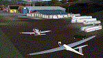
Complete revision of Calcinate del Pesce, airport for gliders. This scenery updates the previous one (Calcinate_v1) issued for FS9 standard meshes, with real meshes and photo-real terrain, multi-season and night. This scenery covers an area of about 17x9 km, from Monate lake (SW) and Medu (NW) to Arcisate (NE) and Bizzozzero/Gurone (SE). This first release includes autogen/library objects for 42% of the total terrain (center/sud-west areas).
The use of this scenery requests: Daniele Lanfranchi's meshes of West Europe for FS9; Itacoast2, italian coast lines review; TreePlanter, extra library for trees; dva51 object library, for extra object library. Enjoy.
| Filename: | Calcinate_del_Pesce__Italy_revision_20.zip |
| License: | Freeware |
| Added: | 27th March 2014, 21:36:35 |
| Downloads: | 620 |
| Author: | Aldo Della Vedova, Daniele Lanfranchi |
| Size: | 35.98 MB |
| Category: Flight Simulator 2004 - Scenery | |
| Port Hardy CYZT in British Columbia, Canada |
|
Images related to this file:
File Description:
Port Hardy airport is on the coast of Vancouver Island in BC, at the far northern end and 5 miles east of the town. The town and the airport are both gateways to local touristic attractions such as Cape Scott Provincial Park, the North Coast and BC Marine Trails, and kayaking, caving, surfing, fishing, camping, and scuba diving (and I discovered just how big orca are). Fishing, logging, and mining have been important and to an extent still are for the town population of just over 4,000. The airport, along with the ferries, connects Port Hardy to the rest of the west coast with Pacific Coastal Saab 340 or Beechcraft 1900C flights to and from Vancouver at least twice a day. There are also Grumman Goose amphibious flights to local float bases such as Port McNeill, Alert Bay, Whaletown, Surge Narrows, Echo Bay, and Minstrel Island. These are all included in the AI and previously posted. There are three runways: 11-29 of 5,000 feet with ILS on 11 and righthand circuits on 29, 07-25 of 4,000 feet with righthand circuits on 25, and 16-34 with a much shortened 3,500 feet on 34 due to a displaced threshold. There is a control tower but it is not manned 24 hours a day; a "mandatory frequency" (MF for short and a Canadian invention) is used by the tower when it is manned, and when there is no tower response the aircraft continues to announce intentions and position. Something I have been meaning to explain to those who query it, is that in real life as well as in FS9 helicopters at a mixed use airport or airfield will act as if they are planes and join downwind, turn on base and then finals, "land" along the runway and then use the taxiway to the parking. This means all aircraft are doing the same thing and an orderly queue avoids collisions. This is one of a series connected in some way with Pacific Coastal airline destinations, the first being Bella Coola. There is AI available for Pacific Coastal online.
| Filename: | Port_Hardy_CYZT_in_British_Columbia_Canada.zip |
| License: | Freeware, limited distribution |
| Added: | 11th November 2018, 16:48:50 |
| Downloads: | 234 |
| Author: | Roger Wensley |
| Size: | 19.26 MB |
© 2001-2026 AVSIM Online
All Rights Reserved
Privacy Policy |