
Where Flight Simulation Enthusiasts Gather from Around the World!
AVSIM Library - Search Results

| Category: Flight Simulator X - Scenery | |
| YNUL Nullagine, Western Australia |

|
File Description:
YNUL Nullagine - Shire of East Pilbara with added ORBX textures. Nullagine is serviced by a gravel airstrip. This facility provides a vital air link. RFDS, Police, and local charter operators all rely on this airstrip for the provision of vital services to the communities. Nullagine is an old goldrush town in Western Australia's Pilbara region. It is located on the Nullagine River 296 km south-east of Port Hedland and 1,364 km north-north-east of Perth on the old Great Northern Highway. The town originated from gold being discovered in the area in 1886 by a prospector, N.W. Cooke. The population increased sharply as a result and by the mid 1890s the community wanted to have a town declared. Lots were surveyed and released in 1897 and the state government gazetted the town in 1899. Nullagine comes from the Aboriginal name of a nearby river, the Ngullagine river; the meaning of the word is unknown. Besides gold other minerals were mined in the area including diamonds and other gemstones. Between 1895 and 1914 the town boomed and contained a number of general stores, three hotels, eight stamp mills and a population of over 3,000. Its population was 1,500 prior to World War II. Now, with the decline of gold mining, only about 200 remain. However the town still attracts fossickers and prospectors who visit the surrounding area, which is particularly rich in minerals such as agate, asbestos, antimony, beryl, chalcedony, copper, jade, jasper, manganese, tiger eye and wolfram. The town is also the place of the Yirrangadji Aboriginal Community. The Martu people make up the bulk of this population. REQUIRES Blencowe_LibraryKit.zip
REQUIRES blencowe_librarykit_309494.zip (Available HERE)
| Filename: | YNUL_Nullagine_Western_Australia.zip |
| License: | Freeware |
| Added: | 28th February 2013, 14:00:15 |
| Downloads: | 292 |
| Author: | Alan Blencowe |
| Size: | 5.72 MB |
| Category: Flight Simulator 2004 - AFCAD Files | |
| Hamburg - Fuhlsbuttel, Germany (EDDH) |
|
File Description:
This is an AFCAD file, for the Hamburg scenery by German Airports 3 (Aerosoft). This is my first try with AFCAD 2, so please enjoy!
| Filename: | Hamburg__Fuhlsbuttel_Germany_EDDH.zip |
| License: | Freeware |
| Added: | 31st October 2003, 17:01:31 |
| Downloads: | 1,694 |
| Author: | Max Adolph, German Airports 3 |
| Size: | 7.53 KB |
| Category: Flight Simulator 2004 - Aircraft Repaints, Textures and Modifications | |
| Swissair A320 Series |
|
File Description:
Once again some Swissair textures by me. This time for the A320 series by Overland, which means that I've included the A319, A320 and A321.
| Filename: | Swissair_A320_Series.zip |
| License: | Freeware |
| Added: | 29th January 2007, 03:18:37 |
| Downloads: | 590 |
| Author: | Max Hergemoeller ; Overland / Simmer's Sky |
| Size: | 6.6 MB |
| Category: Flight Simulator X - Utilities | |
| FSX Settings Editor Version 1.1 |
|
Images related to this file:
File Description:

Update! New version fixes WideViewAspect setting not working in the earlier version. It also lets you see the last profile that was applied. Please uninstall the earlier version, and then install this.
FSX Settings Editor lets you create fsx.cfg profiles for different scenarios which you can quickly apply to your fsx.cfg file. Create different settings profiles and switch between them quicker than ever before. Some of the scenarios for which profiles can be created:
- Flying Rural Areas with Light GA Aircraft (Graphics can be set High)
- Flying Dense Urban Areas (Graphics can be lowered to improve FPS)
- Different profiles for flying VFR, IFR, max weather, min weather max terrain etc
- Testing out different settings to achieve max FPS with acceptable eye-candy
I created this tool to help me quickly change my FSX settings to the type of flight I intend to perform. Manually editing the fsx.cfg file, keeping separate copies of fsx.cfg file for different scenarios, or using the limited FSX save config functionality proved cumbersome and time-consuming.
Please backup your fsx.cfg before using this tool. Comments, issues, questions or suggestions are welcome.
Requires Microsoft .Net 4.0 Client Profile Installed. To Install: Run the setup and launch the program from your desktop. Email: [email protected]
| Filename: | FSX_Settings_Editor_Version_11.zip |
| License: | Freeware |
| Added: | 27th September 2015, 20:26:01 |
| Downloads: | 1,369 |
| Author: | Vishal Agarwal |
| Size: | 268.17 KB |
| Category: Flight Simulator 2002 - Scenery Design | |
| Taxiway Signs for St-Croix (TISX) Christiansted, Virgin Islands |
|
File Description:
FS2002 Scenery--St-Croix (TISX) Henry E. Rohlsen, Christiansted, Virgin Islands. Complete with fictional numbers the taxiways, gates and parkings of the default scenery in Christianstedt/St-Croix, Virgin Islands. All signs have night textures and the taxiway middlelines are also nightlighted. AFCAD file and installer included. Addition of a fictional apron area right before runway 09 (created to hide the strange white textures near the runway) with hangar, follow-me car, fire truck and small aircraft. NOVA and NOVA Gold textures are required. By Yves Camus.
| Filename: | Taxiway_Signs_for_StCroix_TISX_Christiansted_Virgi.zip |
| License: | Freeware |
| Added: | 11th September 2004, 21:12:29 |
| Downloads: | 351 |
| Author: | Yves Camus |
| Size: | 587.71 KB |
| Category: Flight Simulator X - Scenery | |
| Death Valley National Park - California, USA |
|
Images related to this file:
File Description:
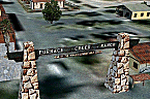
FSX Scenery--Death Valley. This scenery covers several areas of Death Valley National Park (CA). See the World's lowest golf coarse at Furnace Creek Ranch, the moving rocks at the RaceTrack, Scotty's Castle, Panamint Spring, and Stovepipe Wells. Custom designed buildings with photorealistic textures, night textures, and satellite image for the grounds. This scenery has been tested on FSX Gold Edition (FSX Deluxe and Acceleration Expansion Pack), FSGenesis 9.6 terrain mesh, and Win7 operating system. Requires RWEOBJv5.zip & RWEOBJc5.zip (or later) Object Libraries. By Ron Ezra.
| Filename: | Death_Valley_National_Park__California_USA.zip |
| License: | Freeware |
| Added: | 13th January 2016, 22:23:10 |
| Downloads: | 455 |
| Author: | Ron Ezra |
| Size: | 5.53 MB |
| Category: Flight Simulator X - Scenery | |
| California Central Coast Scenery for FSX with Megascenery Earth (Default Mesh Terrain) |
|
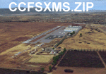
Images related to this file:
File Description:
Revised 1/7/10 for upload to Avsim.COM. CCFSXMSFix is incorporated so not required.
This is an earlier version of CCC Megascenery Earth scenery that doesn't require FSGenesis Mesh Terrain. See CCFSXMSG.ZIP for the FSGenesis Mesh version.
This scenery covers the California coastal region from N36���°10' (Coalinga) to N34���°25' (Santa Barbara) and from the coast East to W119���°40'. It is a version of my previous California Central Coast scenery redesigned and expanded to work with MegaScenery Earth from PC Aviator Inc. Many airstrips in the area covered by this scenery have been added or enhanced for a total of 27 airports/airstrips in the area. Several areas of interest such as the Santa Barbara marina, Morro Bay, etc. are also included for a total of 41 points of interest. All airports/airstrips and related structures have been adjusted and realigned to conform to actual positions and dimensions as indicated by the MegaScenery satellite textures. In addition, there are 6 invisible water runways for use by AI floatplane traffic. MegaScenery California-13, -14 and -15 are required for this scenery to make sense. I also used California-12, -28 and -29 when constructing the scenery but they could be considered optional.
| Filename: | California_Central_Coast_Scenery_for_FSX_with_Mega.zip |
| License: | Freeware |
| Added: | 7th January 2010, 21:28:45 |
| Downloads: | 1,559 |
| Author: | Al Wheeler |
| Size: | 8.12 MB |
| Category: Flight Simulator 2004 - Scenery | |
| Coast Line Update for Scotflight Scenery and Roads and Rivers of Eurpore |
|
File Description:
Updates and additions to coastlinefixes. This is an attempt to recrify the problems encountered when using both Scotflight scenery and Roads and Rivers of Europe.
| Filename: | Coast_Line_Update_for_Scotflight_Scenery_and_Roads.zip |
| License: | Freeware |
| Added: | 21st March 2006, 01:49:12 |
| Downloads: | 596 |
| Author: | stephen flannigan |
| Size: | 39.39 KB |
| Category: Prepar3D V5 - Aircraft Repaints, Textures and Modifications | |
| Cayman Airways VP-CKY 90's Retro Livery Boeing 737 MAX 8 |
|
File Description:
90s Retro livery with HD details capturing the essence of Cayman Airways. Reg: VP-CKY was originally a Boeing 737-300, the workhorse for CAL.
This repaint is intended for the iFly MAX-8 aircraft. Accurate depiction of real-world paint with curved stripes at the tail section of the fuselage.
Reworked Landing gear textures, reconstructed fan blades & a dash of HOME in the Mix. Enjoy =]
| Filename: | Cayman_Airways_VPCKY_90s_Retro_Livery_Boeing_737_M.zip |
| License: | Freeware, limited distribution |
| Added: | 9th May 2023, 14:45:16 |
| Downloads: | 11 |
| Author: | Cai Bodden |
| Size: | 15 MB |
| Category: Fly! II - Scenery | |
| Gettaway Island Beta V1 |
|
File Description:
Need a Holiday (Vacation)? This is for you. Though its my Beta test, I thought of you all and wanted to share. Its a basic Island made with 3ds Max and Photoshop. Included is one log cabin for you to stay in. One grass landing strip for your plane, 737s,757s,777s not recomended, lol. Add the Island with Terramodels or the Fly2 Built in scenery editor.
| Filename: | Gettaway_Island_Beta_V1.zip |
| License: | Freeware |
| Added: | 27th November 2004, 17:16:28 |
| Downloads: | 66 |
| Author: | Steve Brown, F2FDesign |
| Size: | 321.81 KB |
© 2001-2026 AVSIM Online
All Rights Reserved
Privacy Policy |