
Where Flight Simulation Enthusiasts Gather from Around the World!
AVSIM Library - Search Results

| Category: Flight Simulator X - AI Aircraft | |
| Norwegian Air Shuttle NAAI Fokker 50 |

|
Images related to this file:
File Description:
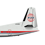
A repaint of the NAAI Fokker 50 into the colors of Norwegian Air Shuttle, circa 2000.
| Filename: | Norwegian_Air_Shuttle_NAAI_Fokker_50.zip |
| License: | Freeware, limited distribution |
| Added: | 21st May 2020, 22:54:21 |
| Downloads: | 89 |
| Author: | Joakim Zenk |
| Size: | 894.54 KB |
| Category: Flight Simulator X - AI Aircraft | |
| Impulse Airlines AIA Boeing 717 |
|
Images related to this file:
File Description:
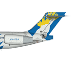
A repaint of the AI Aardvark Boeing 717 into the colors of Impulse Airlines, circa 2000.
| Filename: | Impulse_Airlines_AIA_Boeing_717.zip |
| License: | Freeware, limited distribution |
| Added: | 21st May 2020, 22:54:30 |
| Downloads: | 99 |
| Author: | Joakim Zenk |
| Size: | 1.05 MB |
| Category: Orbiter - Miscellaneous Files | |
| AlignPlane II |
|
File Description:
This is a refinement of the default Align Orbital Plane of Orbiter. It contains a fully functional FDAI which enables the positionning of the spacecraft before the maneuver. Both Inclinaison and LAN can be precisely targeted.
| Filename: | AlignPlane_II.zip |
| License: | Freeware |
| Added: | 14th November 2003, 19:41:01 |
| Downloads: | 2,614 |
| Author: | Y. Ruggeri |
| Size: | 1.36 MB |
| Category: Flight Simulator 2004 - Scenery | |
| Trapani (LICT), Sicily, Italy, Photo Real |
|
Images related to this file:
File Description:
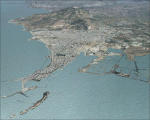
This file contains the photoreal scenery of western part of Sicily (Italy). The airport of Trapani Birgi (ICAO code LICT) is found inside the scenery. The Photo Real Scenery is wide for around 2400 squared Kms.
| Filename: | Trapani_LICT_Sicily_Italy_Photo_Real.zip |
| License: | Freeware |
| Added: | 2nd June 2010, 20:13:55 |
| Downloads: | 16,575 |
| Author: | Fulvio Mazzokan, Flynat |
| Size: | 67.03 MB |
| Category: Flight Simulator 2004 - Scenery | |
| Lamezia (LICA), Calabria, Italy, Photo Real |
|
Images related to this file:
File Description:

This file contains the photoreal scenery of central part of Calabria (Italy). The airport of Lamezia Terme (ICAO code LICA) is found inside the scenery. The Photo Real Scenery is wide for around 2500 squared Kms.
| Filename: | Lamezia_LICA_Calabria_Italy_Photo_Real.zip |
| License: | Freeware |
| Added: | 3rd June 2010, 22:43:24 |
| Downloads: | 16,839 |
| Author: | Fulvio Mazzokan |
| Size: | 71.47 MB |
| Category: Flight Simulator X - Aircraft Repaints, Textures and Modifications | |
| Orbit Airlines Boeing 777-200 LR (Revised) |
|
Images related to this file:
File Description:
Works in FSX only! I made a revision. I smoothed out some of the orange trip on the bottom part of the fuselage. It is still a bit out of sync on top towards the tail.
| Filename: | Orbit_Airlines_Boeing_777200_LR_Revised.zip |
| License: | Freeware |
| Added: | 23rd December 2016, 18:09:24 |
| Downloads: | 189 |
| Author: | Paul Rickard |
| Size: | 5.95 MB |
| Category: Flight Simulator X - Missions | |
| CatharesTour1.zip |
|
File Description:
Intermediate helicopter mission. Take passengers on a sightseeing tour of the Cathares region of France. This is tour one of two. Requires one additional download for the scenery. See the instructions included in the zip file.
| Filename: | CatharesTour1zip.zip |
| License: | Freeware |
| Added: | 11th September 2020, 19:38:28 |
| Downloads: | 79 |
| Author: | helomissionman |
| Size: | 11.76 MB |
| Category: Flight Simulator 2004 - Scenery | |
| CWCP - Cape Parry - Northwest Territories, Canada |
|
Images related to this file:
File Description:
This is a DEW line Main Station on the shore of the Canadian mainland at the far northern tip of Cape Parry. It is 60 miles north of Paulatuk, which is at the base of the Parry Peninsula, and 120 miles south of Sachs Harbour on Banks Island. The station ceased operations in 1989 and a North Warning System automated station was opened in the same year; the NWS station is not shown in this scenery as I have no information regarding it's location or layout. The runway is just over 5,000 feet of gravel 150 feet wide, aligned 037T at an elevation of 119 feet ASL. There is a large apron with a large hangar and a small shelter building for passengers. There are of course no lights, signage, or windsock. The station is up on the hill at 210 feet ASL. This is one of the more interesting stations in terms of size and complexity.
| Filename: | CWCP__Cape_Parry__Northwest_Territories_Canada.zip |
| License: | Freeware, limited distribution |
| Added: | 25th December 2012, 19:07:24 |
| Downloads: | 302 |
| Author: | Roger Wensley |
| Size: | 1.61 MB |
| Category: Flight Simulator 2004 - Scenery | |
| Hatay Airport V2 LTDA |
|
File Description:
Highly detailed scenery of Hatay New Airport V2 (LTDA) in The Turkey.
Antakya or Hatay, as its official name is today, was founded in 300 BC as Antioch-ad-Orontes by Seleucos Nicator, one of Alexander's generals. Antakya grew quickly to become a city of half a million people and, under the Romans, became one of the main centers of the Christian faith. The city survived a massive earthquake in the 5th century killing 250,000 people. It was later fought over by Persians, Byzantines, Arabs, Armenians, Seljuks, Crusaders and Mamluks. The latter literally wiped out the city and it never regained its former glory. Antakya was part of the French protectorate of Syria until 1939, became independent as the Republic of Hatay for a short period and then joined the Republic of Turkey on 23 July 1939.
| Filename: | Hatay_Airport_V2_LTDA.zip |
| License: | Freeware |
| Added: | 8th March 2008, 22:36:31 |
| Downloads: | 2,061 |
| Author: | Vedat Sencan |
| Size: | 2.07 MB |
| Category: Flight Simulator 2004 - Scenery | |
| Hall Beach CYUX in Nunavut, Canada |
|
Images related to this file:
File Description:
Hall Beach is on the Melville Peninsula, part of the mainland of Canada, south and west of Baffin Island. It is around 40 miles south of Igloolik and 50 miles west of Rowley, both of them my previous posts. The airfield was built to support the construction and operation of a main DEW line radar station and to support the rest of the associated chain. Because of the employment opportunities this brought, a village developed nearby. The airfield continues in regular use and the runway, though still gravel, is 5,400' long and 150' wide and lighted; the alignment is 124T and 304T as this is in northern domestic airspace and bearings are given as 'true" and not "magnetic". There are scenery folders for the village, roads, grass, etc, and AI for two airlines with regular service to Hall Beach.
| Filename: | Hall_Beach_CYUX_in_Nunavut_Canada.zip |
| License: | Freeware, limited distribution |
| Added: | 22nd November 2011, 14:33:08 |
| Downloads: | 456 |
| Author: | Roger Wensley |
| Size: | 3.83 MB |


© 2001-2026 AVSIM Online
All Rights Reserved
Privacy Policy |