
Where Flight Simulation Enthusiasts Gather from Around the World!
AVSIM Library - Search Results

| Category: Flight Simulator 2004 - Scenery | |
| Kotzebue PAOT on the northwestern coast of Alaska |

|
Images related to this file:
File Description:
There are four main northwestern Alaska towns which have good airports and are serviced by Alaska Airlines. From these airports local flights connect to nearby villages, "nearby" in Alaska meaning up to 150 miles away. The northernmost is Barrow. Southwest of Barrow is Kotzebue, then Nome, and the furthest south is Bethel. The town of Kotzbue is north of the Bering Strait on the northwestern coast, 320 miles southwest of Barrow. The population is just over 3,000 people. The location was for a long time a base for trading in furs, with three rivers emptying into the sea and providing routes into the interior land and villages; a meeting place between hunters and traders from Russia and elsewhere. The Kotzebue airport is called the Ralph Wien Memorial and has two runways. The modern one is aligned 08-26 and is 5,880 feet of 150 feet wide asphalt built across a shallow lagoon, with an ILS on 08 and PAPI on both ends. The second and older runway is originally military and gravel, aligned 17-35 and 3,786 feet long and used (wind allowing) by the GA planes that park alongside the runway. The prevalent wind is from the west; when the wind is from the east it is generally relatively feeble and with a much lower cloud base, possibly to the ground, hence the need for an ILS. All AI aircraft in FS9 much prefer to use a runway that has an ILS and so will continue to use 08-26 even if the wind is from the south until it reaches 30+ knots, even if they are a Cessna 150 flying VFR. So for AI realism in FS9 a northern or southern wind needs to be a strong one so that the runway is actually used. However, as Alaska Airlines, Northern Air Cargo, and Everts Air also fly to Kotzebue and can only use the east-west runway (as less than 4,000 feet of asphalt would be seriously inconvenient for a Boing 737 or DC6) it is necessary to have the northern or southern wind UNDER 30 knots at the times when they are landing or taking off. Your choice. I suppose a permanent strong wind from the west would be the most realistic on a daily basis, deterring all planes from ever using 17-35. The AI will develop along with further scenery additions in the neighbourhood.
| Filename: | Kotzebue_PAOT_on_the_northwestern_coast_of_Alaska.zip |
| License: | Freeware, limited distribution |
| Added: | 2nd August 2016, 16:47:52 |
| Downloads: | 463 |
| Author: | Roger Wensley |
| Size: | 19.32 MB |
| Category: Flight Simulator 2004 - Scenery | |
| Sisimiut (BGSS) on the west coast of Greenland |
|
Images related to this file:
File Description:
Sisimiut is on the west coast of Greenland. It is around 125 miles south of Aasiaat, and 80 miles west of Kangerlussuaq airport, which is currently the largest commercial airfield in Greenland. Sisimiut has a population of 5,500 and the main occupations are fishing, tourism, education, and a growing industrial base. It has the northernmost year-round ice-free port in Greenland, though icebergs floating down from the north are commonplace. The airport is across a bridge and along a two mile road on the north side of an inlet, northwest of the town. The runway is 2,600+ feet of asphalt almost 100 feet wide and lit, aligned 20/02 and at 33 feet ASL, with the apron and terminal building at the eastern end. The building is identical to the one at Aasiaat. Air Greenland run regular flights with a Dash-8, Dash-7, or Twin Otters; within FS9 it is impossible to land an Ai Dash-7 on a runway less than 3,000 feet long, so I used a Dash-8. There was no way to replicate both the parking facing away from the terminal AND the "through" taxiing to complete the circle back to the runway; after parking correctly the AI Air Greenland plane will reverse before heading out to take off. The surrounding area is rock with some scruffy grass and low bushes, and there is no grass around the runway; the airfield has compacted gravel instead.
| Filename: | Sisimiut_BGSS_on_the_west_coast_of_Greenland.zip |
| License: | Freeware, limited distribution |
| Added: | 28th April 2012, 22:03:35 |
| Downloads: | 853 |
| Author: | Roger Wensley |
| Size: | 3.71 MB |
| Category: Flight Simulator X - Aircraft Repaints, Textures and Modifications | |
| "Pride of the Middle East" Boeing 777-200LR |
|
File Description:
Textures only for the PMDG B777-200LR model.
Plane textures are based on one of the Emirates A320s (http://www.cardatabase.net/modifiedairlinerphotos/photos/big/00013930.jpg).
| Filename: | Pride_of_the_Middle_East_Boeing_777200LR.zip |
| License: | Freeware |
| Added: | 29th August 2014, 16:16:57 |
| Downloads: | 1,029 |
| Author: | Por Por Tapatt |
| Size: | 14.02 MB |
| Category: Combat Flight Simulator 1 and 2 - Missions | |
| Falklands-Malvinas Missions of the 21th May 1982 |
|
File Description:
This is a set of missions for CFS addon HArrier Jump Jet of Just Flight.
You have 12 missions for the 800th, 801th RN FRS.1 Harrier, RAF No.1 Squadron
Harrier GR.3, Fuerza Aerea Argentina A-4C Brigada IV, A-4B Brigada V, IAI
Dagger Brigada VI, Brigada III IA-58 Pucara, and CAN(Comando Aviación Naval)3th
Escuadrilla de Ataque.
All this missions were historical acomplished the 21-05-82 and in the missions
you have:
-Right time and geographical situation
-Right Aircrafts registrations
-Right Squadrons
-Right Indicatives Squadrons
-Right Pilots names
-Right aircraft number for each historical mission
-Relative strategical situation with the limitations CFS( some
problems for the height flight ,specially for the low altitude
of the attacks of the FAA planes)
-Right ships names and positions this day hour per hour
-Right Meteo and visibility
That was a big work of investigation to find all this informations and all corrections are welcome.There are not fantasie or fiction in this missions.
In memoriam to Lt Daniel Manzotti,Lt Néstor López,Lt Pedro Bean,TN Marcelo Marquez,
Sgt Andy Evans,LT Ken France,Lance Corporal Pat Giffin and all others were lost our life on duty in this day and tragic war.
| Filename: | FalklandsMalvinas_Missions_of_the_21th_May_1982.zip |
| License: | Freeware |
| Added: | 20th December 2003, 03:31:58 |
| Downloads: | 723 |
| Author: | Daniel Nole |
| Size: | 205.14 KB |
| Category: Prepar3D V5 - Aircraft Repaints, Textures and Modifications | |
| Douglas C-47's of the 44nd TCG |
|
Images related to this file:
File Description:
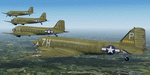
This folder contains repaints for version 3.14 of the Douglas C-47 by Manfred Jahn and colleagues in the colors of 4 aircraft of the 442nd TCG, based in airfield B24 St Andre de l'Eure in March 1945. Included are C-47A-15-DK 42-92879 J7-T of the 303th TCS, C-47A-20-DK 42-93717 V4-F "Carolina Queen" of the 304th TCS, C-47A-80-DL 43-15064 4J-O "Lady Beth" of the 305th TCS and C-53D-DO 42-68840 7H-P "Precious Cargo" of the 306th TCS. Due to the lack of adequate photo material of 442nd aircraft, I have been creative with some of these paints. Repaint by Jan Kees Blom for Manfred Jahn's C-47 version 3.14, based on the paintkit by Gman5250.
| Filename: | Douglas_C47s_of_the_44nd_TCG.zip |
| License: | Freeware |
| Added: | 23rd November 2020, 20:15:20 |
| Downloads: | 153 |
| Author: | Jan Kees Blom |
| Size: | 36.08 MB |
| Category: Flight Simulator 2004 - Scenery | |
| Nome PAOM on the northwestern coast of Alaska |
|
Images related to this file:
File Description:
There are four main northwestern Alaska towns which have good airports and are serviced by Alaska Airlines. From these airports local flights connect to nearby villages, "nearby" in Alaska meaning up to 200 miles away. The northernmost is Barrow. Southwest of Barrow is Kotzebue, then Nome, and the furthest south is Bethel. The town of Nome is south of the Bering Strait on the southern coast of the Seward Peninsula, around 185 miles south of Kotzebue, with a population of about 3,800. It is the town that led to the creation of the most famous dogsledge race in the world, the Iditarod, which is based on the delivery to Nome of diphtheria serum during the blizzard conditions of the winter of 1925. The Nome airport (it currently has no other name) was originally built as the last of the refuelling airfields for planes being ferried to Russia during WW2. It has two runways, aligned 09-27 and 02-20 in FS9 (the wandering magnetic north has recently renamed the magnetic headings) and both of them around 6,000 feet with an ILS on 27. There is a modern airport layout diagram included showing taxiway names etc. Alaska Airlines, ERA, and Bering Air (which is headquartered in Nome), along with the shared cargo terminal for Northern Air Cargo and Everts Air, are all on the southern apron. The northern apron is mainly for GA, along with maintenance facilities, a garage building that also houses a weather bureau, and at the far northern end of runway 02-20 an apron and hanger for the Alaska Air National Guard. All AI aircraft in FS9 much prefer to use a runway that has an ILS and so will continue to use 09-27 even if the wind is from the north or south, right up until it reaches 30+ knots, so for AI realism in FS9 a permanent wind from the west would be the most realistic on a daily basis. There is also a small gravel strip just north of the town and this is included (94Z), as are some old line-of-sight radio communication reflectors on the hills above the town. There is a note about making adjustments to Ultimate Terrain Alaska-Canada regarding both realistic road lighting and also auto-generation.
| Filename: | Nome_PAOM_on_the_northwestern_coast_of_Alaska.zip |
| License: | Freeware, limited distribution |
| Added: | 18th October 2016, 02:38:42 |
| Downloads: | 488 |
| Author: | Roger Wensley |
| Size: | 22.65 MB |
| Category: Flight Simulator X - Aircraft Repaints, Textures and Modifications | |
| Alaska Spirit Of the Islands Boeing B737-800 |
|
Images related to this file:
File Description:
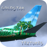
Alaska Airlines' New Scheme - Spirit of the Islands N560AS in all it's glory for the PMDG 737-800NGX. Install via the PMDG Livery manager. Read Me and screenshots included!
Enjoy!!
| Filename: | Alaska_Spirit_Of_the_Islands_Boeing_B737800.zip |
| License: | Freeware |
| Added: | 16th August 2013, 18:25:13 |
| Downloads: | 4,087 |
| Author: | Alex Farmer |
| Size: | 25.35 MB |
| Category: Flight Simulator 2004 - Scenery | |
| Democratic Republic of the Congo Scenery Pak 1 |
|
File Description:
FS2004 Scenery enhancement. This adds parking areas, buildings, and objects to 2 small airfields in the Democratic Republic of the Congo. Freeware by Dale baker.
| Filename: | Democratic_Republic_of_the_Congo_Scenery_Pak_1.zip |
| License: | Freeware |
| Added: | 26th December 2006, 10:45:36 |
| Downloads: | 1,482 |
| Author: | Dale Baker |
| Size: | 679.19 KB |
| Category: Flight Simulator X - Aircraft Repaints, Textures and Modifications | |
| Grumman F7F Tigercat (N207F) "King of the Cats" |
|
Images related to this file:
File Description:
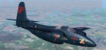
This folder contains a repaint for the freeware F7F Tigercat for FSX by Milton Shupe and team. It shows the 2-seat F7F-3P Tigercat N207F "King Of The Cats" that was on display at the Palm Springs Air Museum, Palm Springs CA, from 2001 until it was sold in 2010. I believe it is currently in Minnesota. Repaint by Jan Kees Blom, based on the original textures by Gman5250.
| Filename: | Grumman_F7F_Tigercat_N207F_King_of_the_Cats.zip |
| License: | Freeware |
| Added: | 10th November 2019, 17:50:51 |
| Downloads: | 105 |
| Author: | Jan Kees Blom |
| Size: | 25.92 MB |
| Category: Flight Simulator X - Aircraft Repaints, Textures and Modifications | |
| Modification of the power table CONTINENTAL IO-520M of Cessna C310R ALABEO. |
|
Images related to this file:
File Description:

New update of flight dynamics settings.
Corrected the indicated speed error (KIAS) vs the true speed (KTAS) according to the data suggested in the pilot's operating manual (POH).
In some cases the position of the center of gravity unladen weight is corrected for a better weight and balance of the airplane.
Actual direct references from Pilot Operations Manual (POH) for specific details, Power,
Nose or pitch position and weight and balance settings, airplane geometry, piston or turbine engine data,
propeller and everything that refers to references, also the real references of the manufacturers of sea engines whatever the specific case.
| Filename: | Modification_of_the_power_table_CONTINENTAL_IO520M.zip |
| License: | Freeware |
| Added: | 15th April 2020, 18:45:55 |
| Downloads: | 127 |
| Author: | Rafael Ledezma |
| Size: | 114.82 KB |


© 2001-2026 AVSIM Online
All Rights Reserved
Privacy Policy |