
Where Flight Simulation Enthusiasts Gather from Around the World!
AVSIM Library - Search Results

| Category: Flight Simulator 2004 - Sounds | |
| ATC Voices -Airport Names Set 8 |

|
File Description:
A collection of 28 additional and corrected airport names, for use with Flight Simulator 2004 and FS2002. Installation requires the EditVoicepack software by Lars Møllebjerg which is also available free download from the usual Flight Simulator download sites such as Avsim.
The airports represented here are:
64I: Lee Bottom (United States of America),
IWK: Wales (United States of America),
KCMX: Houghton Co Meml (United States of America),
KERR: Errol (United States of America),
KMPV: Knapp State (United States of America),
KMVL: Morrisville Stowe State (United States of America),
KSCX: Scott Municipal (United States of America),
KSHL: Sheldon Mun (United States of America),
KSIK: Sikeston Meml Mun (United States of America),
LDDP: Ploce (Croatia),
LDPV: Vrsar (Croatia),
LFLX: Deols/Chateauroux (France) - fix,
LIPV: Venice San Nicolo (Italy),
LSME: Emmen (Switzerland),
MDCR: Cabo Rojo (Dominican Republic),
OIBJ: Jam/Tohid (Iran),
OIBV: Lavan (Iran),
OISR: Lamerd (Iran),
RJSK: Akita (Japan),
RJSR: Odate-Noshiro (Japan),
UHPT: Tilichiki (Russian Federation),
ULAM: Naryan-Mar (Russian Federation),
VEJH: Jharsuguda (India),
WI72: Ellenboro (United States of America),
YAYR: Ayr (Australia),
YJAP: Jabiru (Australia),
YPAM: Palm Island (Australia), and
YWDH: Windorah (Australia).
| Filename: | ATC_Voices_Airport_Names_Set_8.zip |
| License: | Freeware |
| Added: | 8th July 2007, 20:55:00 |
| Downloads: | 2,013 |
| Author: | John Hinson |
| Size: | 20.92 KB |
| Category: Flight Simulator 2004 - Scenery | |
| Kotzebue PAOT on the northwestern coast of Alaska |
|
Images related to this file:
File Description:
There are four main northwestern Alaska towns which have good airports and are serviced by Alaska Airlines. From these airports local flights connect to nearby villages, "nearby" in Alaska meaning up to 150 miles away. The northernmost is Barrow. Southwest of Barrow is Kotzebue, then Nome, and the furthest south is Bethel. The town of Kotzbue is north of the Bering Strait on the northwestern coast, 320 miles southwest of Barrow. The population is just over 3,000 people. The location was for a long time a base for trading in furs, with three rivers emptying into the sea and providing routes into the interior land and villages; a meeting place between hunters and traders from Russia and elsewhere. The Kotzebue airport is called the Ralph Wien Memorial and has two runways. The modern one is aligned 08-26 and is 5,880 feet of 150 feet wide asphalt built across a shallow lagoon, with an ILS on 08 and PAPI on both ends. The second and older runway is originally military and gravel, aligned 17-35 and 3,786 feet long and used (wind allowing) by the GA planes that park alongside the runway. The prevalent wind is from the west; when the wind is from the east it is generally relatively feeble and with a much lower cloud base, possibly to the ground, hence the need for an ILS. All AI aircraft in FS9 much prefer to use a runway that has an ILS and so will continue to use 08-26 even if the wind is from the south until it reaches 30+ knots, even if they are a Cessna 150 flying VFR. So for AI realism in FS9 a northern or southern wind needs to be a strong one so that the runway is actually used. However, as Alaska Airlines, Northern Air Cargo, and Everts Air also fly to Kotzebue and can only use the east-west runway (as less than 4,000 feet of asphalt would be seriously inconvenient for a Boing 737 or DC6) it is necessary to have the northern or southern wind UNDER 30 knots at the times when they are landing or taking off. Your choice. I suppose a permanent strong wind from the west would be the most realistic on a daily basis, deterring all planes from ever using 17-35. The AI will develop along with further scenery additions in the neighbourhood.
| Filename: | Kotzebue_PAOT_on_the_northwestern_coast_of_Alaska.zip |
| License: | Freeware, limited distribution |
| Added: | 2nd August 2016, 16:47:52 |
| Downloads: | 463 |
| Author: | Roger Wensley |
| Size: | 19.32 MB |
| Category: Flight Simulator 2004 - Utilities | |
| LJSceneGen V 1.0 |
|
File Description: LJSceneGen is a scenery creation utility for the Microsoft (MS) Flight Simulator FS9 (aka FS2004 or Century of Flight). The program presents a series of forms where various options for VORs, NDBs, Exclusion Rectangles, Markers, Waypoints and Scenery Library objects can be entered. The program will try to connect FS9 via FSUIPC or WideFS. If a FSUIPC connection is found, the location (Lat. Long. and Alt and others if available and appropriate) will be automatically retrieved. You can also move the aircraft to a new location by entering a Lat. and Long. pair and clicking "Move Aircraft". Multiple combinations VORs, NDBs, Exclusion Rectangles, Markers, Waypoints and Scenery Library objects can be saved and each saved object can be edited. After all the desired objects are created, an XML file can be created. This file can be submitted to the FS2004 SDK BGL compiler "BGLCOMP.exe". A file with an extension of .BGL will result which you then place in your Addon Scenery/scenery/ folder to view your just created scenery object(s) after you restart FS9. This or other properly formulated .XML scenery files can be imported and reviewed. For example, the FS9 file NVNAMC0.bgl can be decompiled, imported into LJSceneGen and then viewed. Alessandro Antonini's excellent BGLXMLdecompiler program makes possible the conversion from NVNAMC0.bgl. to NVNAMC0.xml which can then be read by LJSceneGen. (This file is available at Alec's site: http://www.cpinf.net ). Each VOR and NDB found in this decompiled xml file can be reviewed and if you want, you can move your aircraft to the object's location by clicking "Move Aircraft". This program is written in MS's C# language using .NET framework 1.1. The CLR .NET Framework 1.1 must be installed on your computer before the program will run. The freeware version of Pete Dowson's FSUIPC is not supported. Users should be very familar with the FS2004 scenery SDK. This version only knows VORs, NDBs, Exclusion Rectangles, Markers, Waypoints, and Scenery Library objects. It doesn't yet know about Airports Runways ILSes etc. This is not a "What You See Is What You Get" program but instead takes a semi-automated fill-in-the-blanks approach. The program is a scenery creation utility. As such, inexperienced scenery designers may not find it user friendly.
| Filename: | LJSceneGen_V_10.zip |
| License: | Freeware, limited distribution |
| Added: | 14th March 2004, 01:10:12 |
| Downloads: | 2,411 |
| Author: | Larry Jones |
| Size: | 469.34 KB |
| Category: Flight Simulator X - Scenery | |
| Chicago Midway Airport V2 |
|
File Description:
This is my second version of Chicago Midway Airport in Chicago IL for FSX. This version was created with Airport Design Editor 1.30, which was designed exclusively for use with FSX. The following improvements have been made: 1. All commercial and GA aircraft will park at their assigned spots. All gates for all airlines are included. 2. The vehicle paths have been redesigned, which should eliminate the problem of airport vehicles using taxiways, which can cause taxiing airplanes to come to a standstill and cause traffic to back up. 3. When in tower view, the view will be from the roof of the control tower, thanks to Airport Design Editor. 4. Crosswind runways have been activated, which will open more runways to airline traffic. This is an optional feature, and will be explained in the Readme file. 5. Several fuel trucks have been added, and should serve departing aircraft quickly. 6. Settings have been changed in ADE so that all jetways will display as long as Scenery Density in FSX is set at Normal or higher. Please be aware that this scenery is for use with FSX only. It will not work with FS9.
| Filename: | Chicago_Midway_Airport__V2.zip |
| License: | Freeware, limited distribution |
| Added: | 30th June 2008, 08:50:03 |
| Downloads: | 4,811 |
| Author: | Patrick Finch |
| Size: | 39.13 KB |
| Category: Miscellaneous Files - Demos from Commercial Vendors | |
| Germany Marine, PANAVIA TORNADO |
|
File Description:
The Panavia Tornado is a family of twin-engine combat aircraft, which was jointly developed by the West Germany, United Kingdom and Italy. There are three primary versions of the Tornado; the Tornado IDS (Interdictor/Strike) fighter-bomber, the suppression of enemy air defences Tornado ECR (Electronic Combat/Reconnaissance) and the Tornado F.3 (only United Kingdom) a air fefence variant. It is one of the world's most sophisticated and capable interdiction and attack aircraft, with a long range, large payload and high survivability.
Developed and built by Panavia, a tri-national consortium consisting of MBB of West Germany, British Aerospace, and Alenia Aeronautica of Italy. The Tornado first flew on August 14, 1974, and saw action with the RAF and AMI (Italian Air Force) in the Gulf War (Operation Desert Storm). International co-operation continued after its entry into service within the Tri-National Tornado Training Establishment, a tri-nation training and evaluation unit operating from RAF Cottesmore, England. Including all variants, 992 aircraft were built for the three partner nations and Saudi Arabia (first export customer). Demoversion with banners.
Panel, GAUGES, model, sound and textures by www.afs-design.de - Author: A.Meyer.
| Filename: | Germany_Marine_PANAVIA_TORNADO.zip |
| License: | Commercial demo |
| Added: | 18th October 2008, 22:56:58 |
| Downloads: | 239 |
| Author: | Andreas Meyer |
| Size: | 3.9 MB |
| Category: Flight Simulator X - Original Aircraft | |
| Germany "Bundeswehr", Tornado IDS |
|
File Description:
****This file is a COMMERCIAL DEMO****
The Panavia Tornado is a family of twin-engine combat aircraft, which was jointly developed by the West Germany, United Kingdom and Italy. There are three primary versions of the Tornado; the Tornado IDS (Interdictor/Strike) fighter-bomber, the suppression of enemy air defences Tornado ECR (Electronic Combat/Reconnaissance) and the Tornado F.3 (only United Kingdom) a air fefence variant. It is one of the world's most sophisticated and capable interdiction and attack aircraft, with a long range, large payload and high survivability.
Developed and built by Panavia, a tri-national consortium consisting of MBB of West Germany, British Aerospace, and Alenia Aeronautica of Italy. The Tornado first flew on August 14, 1974, and saw action with the RAF and AMI (Italian Air Force) in the Gulf War (Operation Desert Storm). International co-operation continued after its entry into service within the Tri-National Tornado Training Establishment, a tri-nation training and evaluation unit operating from RAF Cottesmore, England. Including all variants, 992 aircraft were built for the three partner nations and Saudi Arabia (first export customer).
| Filename: | Germany_Bundeswehr_Tornado_IDS.zip |
| License: | Commercial demo |
| Added: | 17th December 2008, 17:07:11 |
| Downloads: | 2,009 |
| Author: | Andreas Meyer |
| Size: | 3.88 MB |
| Category: Flight Simulator X - Scenery | |
| RAF Molesworth |
|
File Description:
At the start of World War II the Air Ministry selected the area as the site for what would become RAF Molesworth. The base was built in 1940 and 1941. The first unit, Royal Australian Air Force 460 Squadron was formed at the base on November 15, 1941 with Vickers Wellington IVs. 460 Squadron departed the field on January 4, 1942. RAF Bomber Command 159 squadron moved in shortly afterwards, however this unit did not remain long, moving to the Middle East on January 12.
Molesworth was one of the early Eighth Air Force stations assigned to the United States Army Air Force (USAAF). In February 1942, General Ira Eaker and four US staff members inspected Molesworth for possible American use, and during 1942 the facility was improved to Class A airfield standard, with all of its runways extended to American specifications for heavy 4-engined bombers. The main runway was lengthened to 2,000 yards and the number of hardstands increased to fifty. It was given USAAF designation as Station 107.
From 16 September 1943 – 18 June 1945, Molesworth served as headquarters for the 41st Combat Bombardment Wing of the 1st Bomb Division.
| Filename: | RAF_Molesworth.zip |
| License: | Freeware |
| Added: | 17th January 2009, 14:00:45 |
| Downloads: | 552 |
| Author: | Scott Berge |
| Size: | 22.77 KB |
| Category: Flight Simulator 2004 - Scenery | |
| Indian Creek Farm Field CF07 near Ottawa in Ontario, Canada |
|
Images related to this file:
File Description:
Indian Creek farm field (Re-upload WITH THE MISSING TEXTURES!) is in Ontario and southeast of Ottawa, less than two miles east of two other real-life farm fields I have already posted (Russell Farm, and Russellette Strip). The creek is just north of the runway in the trees, though it doesn't show in FS with or without Ultimate Terrain.
There is a grass runway 08/26 that is 2,100 feet long and has lights; the grass could be better (I mean there could be more of it) but the drainage is good. There is a large hangar that is right by the house and is heated (wow!); this is for the owner. There are also eight other hangars which are slightly basic and without doors, which means boxes over the wheels so the tires don't get chewed by the wild life and canvas hangar fronts for the winter. All the hangar buildings are modeled specifically for this scenery. The runway has been there for 22 years, and before that (though with a large gap between) there was a military grass strip as a relief field for nearby Pendleton .
| Filename: | Indian_Creek_Farm_Field_CF07_near_Ottawa_in_Ontari.zip |
| License: | Freeware, limited distribution |
| Added: | 8th February 2010, 09:45:16 |
| Downloads: | 443 |
| Author: | Roger Wensley |
| Size: | 11.35 MB |
| Category: Flight Simulator 2004 - Scenery | |
| Kenmore Village Field CF08 near Ottawa in Ontario, Canada |
|
Images related to this file:
File Description:
Kenmore Village Field is in Ontario, at the northwest corner of the village of Kenmore. Kenmore is around 13 miles southeast of Ottawa airport and 3 miles east of Bank Farm Field. The village doesn't appear in FS as it is too small, but I have recreated it based on the roads that show in Ultimate Terrain. There is a grass runway 09/27 (actually 086/266) that is 3,100 feet long, and the grass is good, and with lights. The field is owned by a gentleman in his mid 70's who sold his plane five years ago and less than two years later discovered that he really didn't want to give up flying; he then went out and bought another slightly older and cheaper version of the one he sold. The house is in a direct line with the runway approach from the east; try to miss it. There is a large hangar and workshop behind the house and to the north of the runway center line, and a second older hangar on the same side a bit further along, both modeled specifically for this.
| Filename: | Kenmore_Village_Field_CF08_near_Ottawa_in_Ontario_.zip |
| License: | Freeware, limited distribution |
| Added: | 9th February 2010, 13:39:57 |
| Downloads: | 396 |
| Author: | Roger Wensley |
| Size: | 10.69 MB |
| Category: Miscellaneous Files - Demos from Commercial Vendors | |
| Germany Airforce, ECR Panavia Tornado |
|
Images related to this file:
File Description:
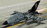
The Panavia Tornado is a family of twin-engine combat aircraft, which was jointly developed by the West Germany, United Kingdom and Italy. There are three primary versions of the Tornado; the Tornado IDS (Interdictor/Strike) fighter-bomber, the suppression of enemy air defences Tornado ECR (Electronic Combat/Reconnaissance) and the Tornado F.3 (only United Kingdom) a air fefence variant. It is one of the world's most sophisticated and capable interdiction and attack aircraft, with a long range, large payload and high survivability. Developed and built by Panavia, a tri-national consortium consisting of MBB of West Germany, British Aerospace, and Alenia Aeronautica of Italy. The Tornado first flew on August 14, 1974, and saw action with the RAF and AMI (Italian Air Force) in the Gulf War (Operation Desert Storm). International co-operation continued after its entry into service within the Tri-National Tornado Training Establishment, a tri-nation training and evaluation unit operating from RAF Cottesmore, England. Including all variants, 992 aircraft were built for the three partner nations and Saudi Arabia (first export customer). Panel, GAUGES, model, sound and textures by www.afs-design.de
| Filename: | Germany_Airforce_ECR_Panavia_Tornado.zip |
| License: | Commercial demo |
| Added: | 26th March 2010, 23:54:57 |
| Downloads: | 160 |
| Author: | Andreas Meyer |
| Size: | 4.37 MB |


© 2001-2026 AVSIM Online
All Rights Reserved
Privacy Policy |