
Where Flight Simulation Enthusiasts Gather from Around the World!
AVSIM Library - Search Results

| Category: Prepar3D V1-4 - Aircraft Repaints, Textures and Modifications | |
| North American P-51D 353rd FG (YJ-L) "Willit Run?" |

|
Images related to this file:
File Description:
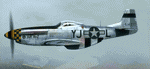
This folder contains a repaint for the A2A WoP3 P-51D Mustang, in the colors of P-51D-10-NA 44-14771 YJ-L "Willit Run?" which flew with the 351st FS, 353rd FG from Raydon in the UK, with Maj Frederick LeFebre as its regular pilot. The P-51 is named “Willit Run?â€, but the nose art on this plane is not talking about this particular aircraft or any P-51 for that matter. It’s an inside joke of WWII vintage.
During WWII, as in every big war, private industry is called upon to produce war goods rather than civilian goods – “guns vs. butterâ€. Henry Ford took on a huge project to contract-build Consolidated B-24 Liberator bombers in a new state-of-the-art manufacturing facility to be built on a farm which Henry Ford owned at Willow Run near Detroit. The facility was to be a prime example of Roosevelt’s “Arsenal of Democracyâ€, conceived and built on an unprecedented scale. Begun in April, 1941, it was the largest enclosed room in the world, with 3.5 million square feet. But Willow Run had a long and troubled construction and start-up time. So long and troubled a start-up, that after two years with little results the public became disillusioned with the project and derisively nicknamed the plant “Willit Run?â€.
Ford persevered however, and Willow Run finally hit its stride, eventually producing at the prodigious rate of 650 B-24 bombers per month by August, 1944. At war’s end, Willow Run had produced about half of the 18,000 B-24's which saw service in the war.
Repaint by Jan Kees Blom, based on the A2A paintkit.
| Filename: | North_American_P51D_353rd_FG_YJL_Willit_Run.zip |
| License: | Freeware |
| Added: | 18th November 2018, 16:21:26 |
| Downloads: | 60 |
| Author: | Jan Kees Blom |
| Size: | 12.3 MB |
| Category: X-Plane - Original Aircraft | |
| Black Cat PBY5/5A |
|
File Description:
X-Plane 6.40
The PBY Catalina is probably the best known flying boat with over 4000 produced by Consolidated aircraft and licensees. The Black Cat squadrons all done in flat black played havoc particularly for the Japanese in the Pacific in WWII. Fitted with radar, with a 15 hour endurance and 2800 mile range they hunted Japanese naval ships and bombed or torpedoed them by the hundreds. This a fairly accurate rendition of the PBY except that the retractable pontoons are missing. Why? Well basically after using all the tricks I know I ran out of parts. There are 6 engine nacelles used in the model, 2 represent the 1200 HP radial engines driving the props, the others are jets with 5 lbs of thrust, 1 is used for the rear fuselage section, 1 is used for the wing pylon, 1 is used for the flare from the fuselage to the vertical stabilizer and the last is used for the forward observation and gunner space. Two are not used. Wing sections are taken up by the main wing and the support spars so there you go. The fuel tanks are used for the side gunner pods since these can be decorated separately. The plane flies very well and is stable. Takeoffs from water are quite easy as long as you don't dip a wing tip (no floats remember). This aircraft model and the paint scheme is copyright by Robert App, January 2003. Feel free to alter the paint scheme and instrument panel as long as you give me credit for the original design. The Black Cat squadron logo used in the paint scheme is courtesy of http://www.daveswarbirds.com/blackcat/logos.htm and is from the VP-71 Black Cat squadron. E mail me with any good panels or paint schemes and I will give full credit if used.
| Filename: | Black_Cat_PBY55A.zip |
| License: | Freeware, limited distribution |
| Added: | 16th January 2003, 02:56:49 |
| Downloads: | 1,386 |
| Author: | Robert L. App |
| Size: | 12.04 MB |
| Category: Flight Simulator 2004 - Scenery | |
| CPR5 - Woodstock - Ontario, Canada |
|
Images related to this file:
File Description:
This is the first of a south Ontario series. Woodstock is a town with a population of around 38,000, located 50 miles west of Lake Ontario. The airfield is 3 miles west of the town, with a single grass runway just over 3,000 feet long and 100 plus feet wide, aligned 05/23 in FS9 (in fact it is now 06/24 due to the magnetic north wandering off during the last 10 years). There have been at different times varying amounts of gravel mixed in with the grass on both runway and taxiway; the majority surface by far is grass and I have left it all as such, as there is no visually convincing way to mix the two without unreal sharp edges. The apron is on the northern side of the runway, and is now modified in shape to maximise the area available for crops. There are 10 "T" hangars and a small clubhouse in a single long building. There is no fuel, runway lighting, or taxiway or apron lights so usage is effectively restricted to daylight hours. To the east of CPR5 and on the edge of the town is a private airstrip with 2,800 feet of asphalt runway; I have added this as a visual reference, along with several large grain silos on the other side of the road. Hidden in plain sight amid the surrounding farmland, the first sighting of CPR5 is actually always of the adjacent and far more visible buildings just to the east of the apron, which are owned by a company that deals with everything to do with boats, up to and including fishing gear. These have been included. As ditches cannot be effectively duplicated in FS9 I have included some fences which do not exist in real life, to give some needed visual clues.
| Filename: | CPR5__Woodstock__Ontario_Canada.zip |
| License: | Freeware, limited distribution |
| Added: | 8th July 2015, 13:36:05 |
| Downloads: | 185 |
| Author: | Roger Wensley |
| Size: | 5.57 MB |
| Category: Flight Simulator 2004 - Scenery | |
| Frozen Canadian & USA Rivers & Lakes Revision |
|
Images related to this file:
File Description:
This "freezes" all lakes and rivers for winter flying and means they can be landed on with skis or wheels; it is meant for low level flying rather than high level jet flights. This edition is complete in itself and now really covers all of Canada and parts of the USA along the border, including large parts of Michigan, Wisconsin, Minnesota, North Dakota, and Montana. It is reversible with an "untick" in the FS scenery library. The revision is the addition of frozen sea in the area of Baffin Island (where I and Sid & Pete have recently posted all of the Baffin Island airfields) as I missed this area last time. Sorry about that. I have spent some time making sure that the sea and the inlets along the coast in the south do not get frozen too, and also some of the lakes that are close to the coast and rarely get cold enough to freeze over. The Great Lakes do not usually totally freeze, but this is an either ON or OFF modification and partial freezing cannot be convincingly simulated, so I went for total ice. Along the north shore I went for the peak of the winter with sea ice all the way to the permanent polar cap; this is not totally realistic as there is usually a partially open lead along the coast, but as with the Great Lakes...... It will work without Ultimate Terrain, but as UT is what gets all the lakes and rivers there and in the right place (except in the far north) it is obviously much improved with UT. The pics show Rockcliffe in the winter with the frozen Ottawa River for real and in FS for comparison; without UT the river would not be in the right place.
| Filename: | Frozen_Canadian__USA_Rivers__Lakes_Revision.zip |
| License: | Freeware, limited distribution |
| Added: | 6th September 2011, 00:42:43 |
| Downloads: | 622 |
| Author: | Roger Wensley |
| Size: | 1.2 MB |
| Category: Flight Simulator 2004 - Scenery | |
| Knight Inlet CF36 float base in British Columbia, Canada |
|
Images related to this file:
File Description:
Knight Inlet is a floating lodge that organises "nature experiences", ranging from close encounters with local grizzly bears to fishing. Knight Inlet is to the north of "the narrows" where the Inside Passage gets squeezed between the mainland and Vancouver Island, and there is a chart section attached with a pointer to the location. At the bottom of the chart is Campbell River floatbase, and to the west is Port Hardy. Knight Inlet initially runs east-west, and the lodge is tucked into a smaller north-south offshoot, close to where the main inlet turns north. The water runway here is in the middle of the north-south offshoot, though of course in reality the "runway" is wherever the wind dictates it to be. The names highlighted in green on the chart are float bases to be renovated and posted with working AI. The buoyed log boom next to the lodge is to keep escaped logs from drifting in and colliding with boats; float plane pilots keep their eyes peeled too. Because of large hills adjacent to the lodge the landing of the AI may or may not take place, depending on wind direction and whether or not they fly into rock before landing. Take off and departure are far more reliable, particularly if the wind is from the south. Most of the AI is from Vancouver Harbour, Harbour Air Otters and West Coast Air Beavers, plus a SeAir Beaver from Campbell River and a private Cessna from the nearby Minstrel Island. This is the second in a series of new and renovated float bases in BC (the first being Sproat Lake) and to cope with the AI demands FSAddon have authorised the inclusion here of a bunch of AI Otters and Beavers that were originally part of a payware scenery for the area. Thanks are due there.
| Filename: | Knight_Inlet_CF36_float_base_in_British_Columbia_C.zip |
| License: | Freeware, limited distribution |
| Added: | 23rd December 2016, 08:16:24 |
| Downloads: | 218 |
| Author: | Roger Wensley |
| Size: | 16.95 MB |
| Category: Flight Simulator 2004 - Scenery | |
| Brevoort CWOB and BAF-3 radar plus Cartwright LAB-6 radar Canada |
|
Images related to this file:
File Description:
Brevoort airstrip and the BAF-3 radar it serves is on Brevoort Island, off one of the southeastern tips of Baffin Island and 140 miles east of Iqaluit. This scenery includes the BAF-3 buildings on the hilltop and those on the airstrip below, plus the roads connecting them and down to the beach landing area on the rocky coast. This scenery is made for the FSGenesis 76m terrain mesh for northern Canada, and there will be a repost of all my northern Canada airfields to suit this; I cannot think now why I never installed this mesh before. The AI reflects the use of civil airlines for resupply and transportation of personnel. Given the terrain the wind should be from the north so that ai lands using the 02 runway. Landing from the north will involve a terrain clash while take off towards the north will not as the climb out clears the hilltop. The video shows the 600 foot cliff at the runway threshold and an Air Tindi plane on the apron. Cartwright CYCA is on the Labrador coast and has been posted by Flight Ontario as part of their Goose Bay and Labrador Regional Airports sceneries. The nearby LAB-6 radar site is included here, connected to CYCA by an extended road. The site uses the same buildings as Brevoort and Saglek (posted recently) and although I have included them here as separate sceneries the contents can be placed in the same folders as Saglek with a saving in duplicated textures. The textures here are more accurate than Saglek so say yes to over-write; a downloader with personal experience of Brevoort noted that in reality they are lighter.
| Filename: | Brevoort_CWOB_and_BAF3_radar_plus_Cartwright_LAB6_.zip |
| License: | Freeware, limited distribution |
| Added: | 20th August 2017, 15:46:36 |
| Downloads: | 175 |
| Author: | Roger Wensley |
| Size: | 4.37 MB |
| Category: Flight Simulator 2004 - Scenery | |
| Dutch Harbour PADU in Alaska PLUS AI Air & Sea |
|
Images related to this file:
File Description:
This is a revised and much-added-to update of my earlier Dutch Harbor post, adding more Air & Sea AI. It is complete in itself and does not require you to have previously installed the original. New parking is for a civilian freighter, a Coast Guard C-130, and Coast Guard helicopters that fly from St Paul Island.
There is also a daily flight from Dutch Harbor to Akutan that will be by the amphibious Goose as there is no land runway at Akutan [more posts follow].
The official airport name is Unalaska, but a seat booked with airlines will be to Dutch Harbor, known from the tv series as a fishing centre with major fish and crab processing plants. In town the largest company is Unisea, taking up all of what was once Expedition Island and the adjacent shoreline. The out-of-town expansion is taking place along the shore of Captains Bay to the southwest, and here the largest is Westward with the uniform green roof for the plant and the residential buildings for seasonal workers.
The airport has just over 3,900 feet of 100 feet wide asphalt, aligned 30/12, lit, and between sea and hill with two aprons at the southeast end. There is no control tower at the airport, so don't be surprised when you are required to contact Cold Bay USAF for landing permission. Runway 30 has at its threshold a road; when a plane is landing or taking off traffic is stopped by barriers and lights. To encourage full use of the runway the fence is made up of plastic rods that bend on impact instead of chainlink topped with barbed wire that will turn a light plane upside down.
| Filename: | Dutch_Harbour_PADU_in_Alaska_PLUS_AI_Air__Sea.zip |
| License: | Freeware, limited distribution |
| Added: | 7th August 2012, 20:56:03 |
| Downloads: | 1,529 |
| Author: | Roger Wensley |
| Size: | 13.4 MB |
| Category: Prepar3D V1-4 - Scenery | |
| Anagni Frosinone Italy N41.44.33 E13.09.42 **V2** |
|
File Description:
Attention: this scenario cancels and replaces the previous Anagni scenario in which the Bergamo_City file was loaded.
Anagni Frosinone Italy N41.44.33 E13.09.42 It is known as the city of the Popes, for having given birth to four popes (Innocent III, Alexander IV, Gregory IX and Boniface VIII) and for being a long residence and papal seat. In particular, the name of Anagni is linked to the events of Pope Boniface VIII and the episode known as the "slap of Anagni", the legend attributes to Sciarra Colonna the act of slapping Pope Bonifacio VIII one of the conclusive acts of the serious conflict between the Pope and the king of France Philip IV, called "the Beautiful".Important VFR point for approaching airport Frosinone. Within the downloaded package you will find readme files for scenery installation. Good fly VFR. Pasquale Marrulli.
| Filename: | Anagni_Frosinone_Italy_N414433_E130942_V2.zip |
| License: | Freeware |
| Added: | 22nd January 2018, 02:07:47 |
| Downloads: | 208 |
| Author: | Pasquale Marrulli |
| Size: | 1.84 KB |
| Category: Flight Simulator X - Aircraft Repaints, Textures and Modifications | |
| Fairchild 24 (PH-FAI) FS537 |
|
Images related to this file:
File Description:
This folder contains a repaint for the Lionheart Fairchild 24, in the colors of FS537, a Fairchild Argus Mk.II which was built in 1939 with serial number R9-418. In the same year it was transported to Europe on SS. "Mauritania" (cargo papers were still available in Switzerland where '418' was registered as HB-EIM). First military registered 43-14459, it later was in service with the RAF as FS537. For a long time this Fairchild flew a regular mail-service in Switzerland. It is currently with the "Early Birds" in Lelystad, the Netherlands, where it has been restored to airworthy condition. I have included two versions, one (FS537) as it may have looked when flying with ATA during the war, ferrying pilots, and one (PH-FAI) as it looks today. Repaints by Jan Kees Blom, based on the paintkit by Lionheart Creations.
| Filename: | Fairchild_24_PHFAI_FS537.zip |
| License: | Freeware |
| Added: | 21st July 2018, 14:48:52 |
| Downloads: | 72 |
| Author: | Jan Kees Blom |
| Size: | 34.38 MB |
| Category: Flight Simulator X - Missions | |
| Flying the 320 |
|
Images related to this file:
File Description:
Learn to fly the next generation aircraft A 320 of Wilco/Feelthere. A guiding copilot will be on your side, going through all procedures with you and giving all important hints during the flight, so that you are able to bring the jet straight into the air and in the end safely back to the ground. The mission based on the real flight of Jet Blue Airlines 241 between Oakland International and Long Beach in Los Angele's. An additional tutorial-document is including, that shows you all gauges, switches and buttons you need for this mission and it shows you all indications of the flight management system appearing on the PFD- and SD-display, sorted by the different phases of the flight. Please notice, that this mission requires the commercial add on of Airbus Volume 1 from Wilco/Feelthere.
| Filename: | Flying_the_320.zip |
| License: | Freeware |
| Added: | 1st May 2010, 00:35:06 |
| Downloads: | 2,453 |
| Author: | Carsten Wanzelius |
| Size: | 24.93 MB |
© 2001-2026 AVSIM Online
All Rights Reserved
Privacy Policy |