
Where Flight Simulation Enthusiasts Gather from Around the World!
AVSIM Library - Search Results

| Category: Flight Simulator 2002 - Scenery | |
| Hokitika Airport, New Zealand. |

|
File Description:
Hokitika is a small town situated on the West Coast of the south island of New Zealand and
was first settled in the 1860’s following the discovery of gold. It developed into a thriving mining town and an important port. The first settlers were John Hudson and James Price who set up a store on the banks of the Hokitika River in 1865 to cater for the miners pouring in following the gold strike in 1864. In 1866, with a population of more than 6000 the town was almost twice it’s present size. People were either digging for gold along the banks of the river or servicing the gold mining industry which had spread along rivers in the region.
| Filename: | Hokitika_Airport_New_Zealand.zip |
| License: | Freeware |
| Added: | 3rd September 2002, 12:16:39 |
| Downloads: | 716 |
| Author: | Clive Ryan |
| Size: | 642.36 KB |
| Category: Flight Simulator 2002 - Flight Plans | |
| Amelia Earhart's 1937 World Flight Commemorative |
|
File Description:
Here is a set of FS2002 flights to commemorate Amelia Earhart's ill-fated 1937 World Flight. She and Navigator Fred Noonan disappeared on 2 July 1937 on their 2224 nm flight from Lae, New Guinea to Howland Island. They had already completed 19,000 nm. There are two options for flying these flights, a 29-leg version matching Earhart's with leg lengths up to 20 hours or a 107-leg version with an average leg length of one and a half hours. Best to fly this commemorative with the Lockheed Electra L10E, but can be flown by other twin-engine aircraft with less realism. Simple one-step installation. Extensive notes accompany the flight descriptions. Includes scenery for airports not available in FS2002.
| Filename: | Amelia_Earharts_1937_World_Flight_Commemorative.zip |
| License: | Freeware |
| Added: | 31st May 2006, 21:21:28 |
| Downloads: | 183 |
| Author: | Charles Wood |
| Size: | 1.74 MB |
| Category: Flight Simulator 2004 - Flight Plans | |
| The flight of Frigate Bird II |
|
File Description:
By 1951 the final ocean to be traversed for air travel was the South Pacific between Australia and South America.
On 13 March 1951 Cpt. P.G. Taylor set off from the flying boat base at Rose Bay in Sydney with a crew of four. They made a shakedown flight to Grafton, NSW, landing on the Clarence River, and next morning headed east for South America. Stops were made at Noumea; Fiji; Samoa; Cook Islands; Tahiti; and Mangareva, French Oceania and then Easter Island before arriving in Valparaiso on 26th. March 1951.
The aircraft was subsequently presented to Captain Taylor by the then Prime Minister, Sir Robert Menzies, in recognition of the first air-crossing of the South Pacific Ocean and other pioneering flights.
| Filename: | The_flight_of_Frigate_Bird_II.zip |
| License: | Freeware |
| Added: | 12th January 2006, 14:44:25 |
| Downloads: | 605 |
| Author: | Bruce Kennewell |
| Size: | 497.41 KB |
| Category: Flight Simulator X - Scenery | |
| IGT - Nightmute Airport - Alaska, USA |
|
Images related to this file:
File Description:
The airport islocated southeast of the central business district of the vellage of Nightmute.Nightmute is located on Nelson Island near Toksook Bay. The two villages connect by snowmachine trail in winter.
Runway 2/20 was changed to 3/21. Changed the length of Runway 3/21 from 50 feet wide and a legth of 1,600 feet to 75 feet wide and 3,200 feet long.Added Runway 11/29 along with custom models.Changes are based on construction plans dated 2005.
Created with Airport Design Editor by ScruffyDuck Software using current FAA documentation and Google Earth's measurements, this package offers a replacement for FSX's stock airport. All these enhancements are as close to the real airport as I can get with stock library objects and custom buildings.
| Filename: | IGT__Nightmute_Airport__Alaska_USA.zip |
| License: | Freeware |
| Added: | 3rd February 2015, 09:12:14 |
| Downloads: | 669 |
| Author: | Wayne Roberts |
| Size: | 197.17 KB |
| Category: Flight Simulator X - Scenery | |
| The French Polynesia Tuamotu Archipelago Scenery X Part A (Tuamotu-X_A) |
|
File Description:
FSX Scenery FRENCH POLYNESIA TUAMOTU ARCHIPELAGO SCENERY Part A
This scenery improves specific area (Tuamotu Archipelago) of FSX.
The archiperago scattered in the northeast of Tahiti island is composed of 78 islands.
I reproduced the 52 islands in the archipelago as add-on senery.
They are islands like a beautiful necklace sprinkled in the tropical ocean.
The French Polynesia Tuamotu Archipelago Scenery X Part A (Tuamotu-X_A)
includes west side of the whole archipelago because of the file size.
This scenery requires Tuamotu-X_B scenery (fpta-xb.zip).
Please be sure to download the Tuamotu-X_B.
When the Tuamotu-X_B scenery is installed together with this scenery,
the huge Tuamotu Archipelago including all of "The Chain Islands" will appear.
By Kazuo Kawamura
| Filename: | The_French_Polynesia_Tuamotu_Archipelago_Scenery_X.zip |
| License: | Freeware, limited distribution |
| Added: | 27th February 2010, 07:36:22 |
| Downloads: | 11,011 |
| Author: | Kazuo Kawamura |
| Size: | 81.3 MB |
| Category: Flight Simulator 2004 - Scenery | |
| Marshall Islands |
|
File Description:
Basic scenery and AFCAD files to create 21 new airstrips in the Republic of the Marshall Islands, and to add facilities to 12 of the default FS9 Marshall Island airports. Also 2 sets of AI flightplans for Air Marshall Islands.
New airstrips: AIC Airuk/Airok, AIM Ailuk, AUL Aur, BII Eneu (Bikini Atoll), EBN Ebadon, EAL Elenak, EBO Ebon, EJT Enajet/Enijet/Enejit, JAT Jabwot/Jabot, JEJ Jeh, KBT Kaben/Kapen, LIK Likiep, LML Lae, LOF Loen, MJE Majkin, NMU Namu, RNP Rongelap, TBV Tabal, UJE Ujae, WJA Woja, WTO Wotho.
Afcads for FS9 airports: 1Q9 Mili, N55 Jaluit, PKMA Enewetak, PKRO Dyess/Roi-Namur, Q30 Mejit, N36 Wotje, 3N1 Taora/Maloelap, N18 Tinak, N20 Ine, Q51 Kili, 3N0 Namorik/Namdrik, 03N Utirik.
| Filename: | Marshall_Islands.zip |
| License: | Freeware |
| Added: | 12th September 2005, 12:18:51 |
| Downloads: | 2,849 |
| Author: | Adrian Wright |
| Size: | 438.48 KB |
| Category: Flight Simulator 2004 - Scenery | |
| Sturt Point CWSP in Nunavut, Canada |
|
Images related to this file:
File Description:
Sturt Point was a DEW line I Station on the south coast of Victoria Island, 50 miles east of Cambridge Bay. It was closed in 1963 but remains in place, though a 5 man I Station has such a small impact on its surroundings that it is hardly visible. The runway is 3,420 feet of gravel aligned 117T/297T, and there are no lights, signage, or windsock, but there are ruts in the gravel. A North Warning System station was built 15 miles inland and closer to Cambridge Bay, operating from 1991 onwards. This has a short (1,280'?) gravel runway aligned 138T/318T (and named CWSX here). No ruts in the gravel, but also still no lights, signage, or windsock.
| Filename: | Sturt_Point_CWSP_in_Nunavut_Canada.zip |
| License: | Freeware, limited distribution |
| Added: | 11th November 2012, 21:07:18 |
| Downloads: | 206 |
| Author: | Roger Wensley |
| Size: | 1.35 MB |
| Category: Flight Simulator 2004 - Aircraft Repaints, Textures and Modifications | |
| SGA DC9-10 TAT-Touraine Air Transport |
|
File Description:
TAT textures for the wonderful FFX/SGA DC-9 10 by Erick Cantu (model) and Fraser Turner (FDE).
You must have the SGA DC-9 10 installed into your FS 2004 library.TAT leased this aircraft from Finnair in 1982/1983 to add capacity on its French domestic network (Mainland and Corsica) and to Sardinia island as well.TAT was the second french domestic carrier after Air Inter and operated regional aircraft like Fokker Nord 262,F27/Fairchild 227 and Fokker28.Some aircraft (F28) were operated on behalf of Air France in Air France color scheme .
Later,Touraine Air Transport was renamed Transport aérien Transrégional.Old aircrafts were sold and were replaced by ATR 42/72,Fokker 100 and 737-200.
TAT merged into Air Liberté October 26,1997.
| Filename: | SGA_DC910_TATTouraine_Air_Transport.zip |
| License: | Freeware |
| Added: | 28th August 2005, 22:37:15 |
| Downloads: | 791 |
| Author: | Patrick Lattarullo |
| Size: | 942.51 KB |
| Category: Flight Simulator 2002 - AFCAD Files | |
| Southern Europe Charter Destinations Pack 2 |
|
File Description:
Second pack of AFCAD files made by myself !
Providing much more parking spaces on these airports, or even enabling AFCAD, for Araxos LGRX !
22 AFCAD files for mediterranean (or further) holidays destinations, for use with DEFAULT FS2002 Scenery
So, here are they : GMAD, Agadir, Morocco ;
LIPR, Rimini, Italy ;
LBWN, Varna, Bulgaria ;
LBBG, Burgas, Bulgaria ;
LCPH, Paphos, Cyprus ;
LDPL, Pula, Croatia ;
LCLK, Larnaka, Cyprus ;
HEBL, Abu-Simbel, Egypt ;
HESN, Aswan, Egypt ;
DTTZ, Tozeur, Tunisia ;
MDPC, Punta Cana, Dominican Republic ;
VAGO, Goa, India ;
HTZA, Zanzibar Island, Tanzania ;
HKMO, Mombasa, Kenya ;
LFTH, Toulon, France ;
LFKJ, Ajaccio, Corsica ;
LFKF, Figari, Corsica ;
LFKB, Bastia, COrsica ;
DTKA, Tabarka, Tunisia ;
LGRX, Araxos Peloponnesos, Greece.
Bonus :-)
LFQQ, Lille, France
OMSJ, Sharjah, United Arab Emirates
I SAY AGAIN : Afcad files for DEFAULT FS2002 scenery !
| Filename: | Southern_Europe_Charter_Destinations_Pack_2.zip |
| License: | Freeware |
| Added: | 20th February 2004, 22:43:42 |
| Downloads: | 1,681 |
| Author: | Philippe Stoffel |
| Size: | 44.73 KB |
| Category: Flight Simulator X - Scenery | |
| Chatham Islands: Updated Airports, Landclass, Water Data, and Flight Plans |
|
Images related to this file:
File Description:
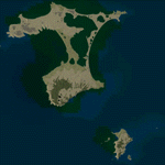
This project significantly updates New Zealand's Chatham Islands and includes more accurate coastlines, lakes, road and river data, as well as corrected landclass and a fully updated Chatham Islands/Tuuta Airport (NZCI). Napier (NZNR) aprons and terminal are also updated to more closely reflect the actual airport and accommodate Air Chathams, and the Pitt Island Airstrip (NZPI) is added to FSX. All updates were done in a manner which carefully aligned airport data with current satellite imagery. These airports are served by Air Chathams. Scenery was created using Airport Design Editor X v1.47.07, SBuilderX 3.13, and the FSX Object Placement Tool. Scenery objects were added and modified from stock FSX scenery to resemble as closely as possible the actual airports.
| Filename: | Chatham_Islands_Updated_Airports_Landclass_Water_D.zip |
| License: | Freeware |
| Added: | 8th July 2011, 21:44:02 |
| Downloads: | 1,674 |
| Author: | Carlyle Sharpe |
| Size: | 17.78 MB |
© 2001-2026 AVSIM Online
All Rights Reserved
Privacy Policy |