
Where Flight Simulation Enthusiasts Gather from Around the World!
AVSIM Library - Search Results

| Category: Flight Simulator X - Scenery | |
| Ascension Island Scenery |

|
File Description:
FHAW- RAF AscenSion Island. Just a basic upgrade of the default scenery. Thnigs added: Terminal building, Airport vehicles, Changed one gate to heavy and one to medium, I've added a concrete section to the apron, I've made the runway the correct length by adding 9 feet, I've put in a smaller tower, I've added a windsock. Built using ADE 1.37.
| Filename: | Ascension_Island_Scenery.zip |
| License: | Freeware, limited distribution |
| Added: | 16th February 2009, 20:18:52 |
| Downloads: | 2,006 |
| Author: | James Parkes |
| Size: | 17.94 MB |
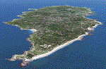
| Category: Prepar3D V1-4 - Scenery | |
| Niue Airport + Island |
|
Images related to this file:
File Description:
Niue is an island country in the South Pacific Ocean, northeast of New Zealand, east of Tonga, south of Samoa, and west of the Cook Islands. Niue's land area is only about 261 square kilometres. Niue International Airport also known as Hanan International Airport, is located near the town of Alofi and currently only serves Air New Zealand, flying to and from Auckland twice a week.
| Filename: | Niue_Airport__Island.zip |
| License: | Freeware, limited distribution |
| Added: | 24th July 2019, 18:55:00 |
| Downloads: | 1,057 |
| Author: | Robert Fluke |
| Size: | 61.22 MB |
| Category: Flight Simulator X - Scenery | |
| Island of Ouessant |
|
File Description:
This scene has been made as a complement for France FVR Bretagne FSX + alro creation Britany Lighthouses paywares.
It covers extensivelly the island of Ouessant and add stuff to ile de Sein and ile of molene. (more than 1000 non generic detailled objets added, some of them stupidly highly detailled, still a concerted effort was made not too affect the FPS)
| Filename: | Island_of_Ouessant.zip |
| License: | Freeware |
| Added: | 3rd May 2010, 06:43:21 |
| Downloads: | 2,466 |
| Author: | etienne v |
| Size: | 7.1 MB |
| Category: Flight Simulator 2004 - Scenery | |
| Kish Island 2004 |
|
File Description:
Kish Island 2004 (OIBK)/
Finally after 7 months of developing and in the following of producing succssecfull sceneries for Iran and after one of the most succssecfull sceneries, "Tehran Scenery 2003", Kish Island 2004 is ready. It is new add-on scenery for Microsoft Flight Simulator 2004 with many new features Include: Complete scenery of the Kish Island, Kish Island Landclass, Waterclass, Very detailed objects, Frequency controlled animation, distance controlled animation, Dynamic scenery, Static Scenery, New and more realistic AFCAD, New roads and night lighting, Corrected navigational data, corrected runways data, Corrected apron and runways lighting system, All in Gmax for better performance, Apron Marshaller, certain number of objects in different scenery complexity setting and ….The scenery replaces the Default scenery of Kish Island which is really terrible. This add-on was developed according to the satellite images of the island provided by the "Kish Free Zone" company and contains 3 packages, the complete scenery of Kish Island, New and More realistic Landclass and Waterclass of the island and New Afcad file which is provided according to jeppesen airport chart. By Touradg Morassaei (www.touradg.tk)
| Filename: | Kish_Island_2004.zip |
| License: | Freeware |
| Added: | 15th December 2003, 05:42:57 |
| Downloads: | 10,066 |
| Author: | Touradg Morassaei |
| Size: | 5.34 MB |
| Category: Flight Simulator 2004 - Scenery | |
| Wake Island 2010 |
|
File Description:
Wake Island scenery (ICAO PWAK) military USAF base in the middle of Pacific ocean. In real life this base was destroyed by typhoon in 2006. In my scenery it is still alive))
| Filename: | Wake_Island_2010.zip |
| License: | Freeware |
| Added: | 6th September 2010, 18:24:00 |
| Downloads: | 1,019 |
| Author: | Alexander Serebryakov 'Sereb' |
| Size: | 22.48 MB |
| Category: Flight Simulator X - Scenery | |
| Yeu island - LFEY |
|
Images related to this file:
File Description:
The island of Yeu (LFEY) is located in the west of France, in the south-west of Nantes. Its main runway is located on the wild coast, near the great lighthouse.
It is made up of :
- A new mesh based ASTER compiled in LOD11 and a very local mesh for the airport, compiled in LOD13 to get a good compatibility with the specific payware meshes.
- Photorealistic texture at 0.5 m/pixel based on aerial photography.
- The airfield and runway. The runway is flat, allowing to preserve the AI traffic. The grass strip is modeled with its relief. There is therefore no AI traffic on the grass strip.
- The port of Port-Joinville and several notable buildings made with Gmax (churches, chapel, castle, fort, ruins, beacons, etc)
- Generic or custom objects created with Gmax (boats, buildings).
| Filename: | Yeu_island__LFEY.zip |
| License: | Freeware |
| Added: | 29th December 2012, 04:03:47 |
| Downloads: | 1,717 |
| Author: | marc guitteny |
| Size: | 217.78 MB |
| Category: Flight Simulator 2004 - Scenery | |
| Margarita Island (SVMG) |
|
File Description:
This is the latest scenery file for Margarita Island (SVMG) - the seventh base of Margarita Air Club.
Margarita Air Club is a virtual flying club based in the Caribbean that beleives that flying on the simulator should be FUN, not a chore. If you like what you see, please visit our website at http://www.margaritaair.com.
DESCRIPTION:
This file is intended to COMPLETELY replace the older versions of SVMG (AVSIM old file name 'svmg.zip'). This file, written in xml language and compiled using the new FS2004 SDK's should be compatible with all near-future versions of MSFS (or at least thats what they promise - LOL).
Once installed, you will see the Margarita Air Club ramp at Del Caribe Airport, and all the TMAC buildings.
AI Aircraft traffic has also been added to the airport. Planes in company colors will be performing T+G's and scheduled cargo runs to some of the neighboring islands several times per day.
| Filename: | Margarita_Island_SVMG.zip |
| License: | Freeware, limited distribution |
| Added: | 27th April 2006, 01:54:21 |
| Downloads: | 4,055 |
| Author: | Todd Lucas |
| Size: | 2.46 MB |
| Category: Flight Simulator X - Scenery | |
| Puerto Rico Island |
|
Images related to this file:
File Description:
Scenery of Puerto Rico island. See readme
| Filename: | Puerto_Rico_Island.zip |
| License: | Freeware |
| Added: | 7th September 2010, 20:14:43 |
| Downloads: | 2,104 |
| Author: | Toni Agramont |
| Size: | 19.26 MB |
| Category: Flight Simulator X - Scenery | |
| Pagasa Island, Philippines |
|
Images related to this file:
File Description:
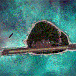
Pagasa Island is a jewel in the South China Sea. It is the one pictured - an emerald splash in an azure sea slashed by a coral runway - whenever new collisions or confrontations are reported in the news for the region. Occupied continuously by the Philippines since 1971, historical use dates back to the Han dynasty, which many believe forms the basis of the Chinese claim to the island. Each country has it's own interpretation of international law and the Filipinos are clearly banking on the precedence of continuous occupation, at no small expense, as Rancudo Field is the farthest airport from Manila within the Philippine sphere of control.
Surprisingly, the geography of the island serves to capture and retain rainwater, although the aquifer is stagnant and the water must be treated for consumption. Sea life remains abundant, poachers take coral heads and sea turtles. There is a solar farm and recently installed solar street lights, fuel for the generators is a precious commodity this far from the mainland.
Sadly, nature may solve the struggle for possession by withdrawing the island from the arena. It is believed that the construction of the runway may have compromised the islands basic integrity, allowing it to crumble into the sea. Whatever the cause, the evidence is clear. Bunkers built during the Japanese occupation in WWII are already slipping beneath the waves and the rate of salt water encroachment has been recorded at close to 6" per day.
There are some things to explore, the grounded BRP Laneo Del Norte to the west; over to the north near the resort grounds are a dugout fishing canoe and some authentic Philippine bangka boats; you may want to load up and head east to do some low warning passes over the Chinese fishing fleet. Standing at the east end of the field, you can just barely spot the China Coast Guard cutter's smoke on the horizon.
The tower is marked by a bright strobe that fires once every five seconds and at night it is bright enough to guide you back to the island from the distance of the fleet. There are no published procedures and the tower is not staffed. Airport ICAO is RPPN.
| Filename: | Pagasa_Island_Philippines.zip |
| License: | Freeware, limited distribution |
| Added: | 10th May 2014, 12:21:19 |
| Downloads: | 1,851 |
| Author: | Rick Keller |
| Size: | 16.17 MB |
| Category: Flight Simulator 2004 - Scenery | |
| Maurice Island Mesh |
|
File Description:
This is a mesh in lod9 for maurice island, based on 3' africa srtm data.
enjoy.
| Filename: | Maurice_Island_Mesh.zip |
| License: | Freeware, limited distribution |
| Added: | 1st April 2004, 16:48:16 |
| Downloads: | 2,162 |
| Author: | Laurent Jean Gabriel |
| Size: | 218.74 KB |
© 2001-2026 AVSIM Online
All Rights Reserved
Privacy Policy |