
Where Flight Simulation Enthusiasts Gather from Around the World!
AVSIM Library - Search Results

| Category: Fly! II - Scenery | |
| Visby Airport (Sweden) |

|
File Description:
Visby is a beautiful Swedish city on the island of Gotland in the Baltic Sea. It is surrounded by an old city wall from medevial times. In the summer tourists are invading the city and the marina is filled with beautiful sailing and motor yachts. The airport (ESSV) is located not far from the city. Some approach and departure plates (SID's STAR's, ILS etc) are enclosed in the "Plates" folder.
| Filename: | Visby_Airport_Sweden.zip |
| License: | Freeware |
| Added: | 19th August 2003, 16:55:18 |
| Downloads: | 239 |
| Author: | Krister Renard |
| Size: | 332.18 KB |
| Category: Flight Simulator 2004 - AI Aircraft | |
| Cessna 421 ZK-LOY |
|
File Description:
ZK-LOY is a privately operated Cessna 421 operated from Ardmore Airfield in the Auckland region of the North Island of New Zealand. (Note: this uses the 402 model - to get tip tanks). Textures only. This repaint is based on Henry Tomkiewicz's payware model and paintkit.
Make sure you visit the New Zealand Flightsim Forums (www.nzff.co.nr) and see how the Great New Zealand Light AI Project is progressing.
| Filename: | Cessna_421_ZKLOY.zip |
| License: | Freeware |
| Added: | 5th August 2006, 05:23:30 |
| Downloads: | 397 |
| Author: | Steve Jenks, Henry Tomkiewicz |
| Size: | 69.52 KB |
| Category: Flight Simulator 2004 - Aircraft Repaints, Textures and Modifications | |
| Matsakoni Airlines Virtual 737-600 |
|
File Description:
Textures only for PMDG Boeing NG 737 600 in Matsakoni Airlines Virtual colours) registration SX-MAV. Matsakoni Airlines was founded in early 2002 and its HQs is based on Corfu island. It has affiliates and hubs on other major Greek and in European cities. It is a brand new operator connecting the Greek islands to major European and over Atlantic cities on a daily base with scheduled and non-scheduled flights.
| Filename: | Matsakoni_Airlines_Virtual__737600.zip |
| License: | Freeware |
| Added: | 19th April 2007, 02:44:35 |
| Downloads: | 178 |
| Author: | Nikos Oikonomidis, Dimitris Pastarmatzis |
| Size: | 8.27 MB |
| Category: Flight Simulator 2004 - Aircraft Repaints, Textures and Modifications | |
| Matsakoni Airlines Virtual 737-700 |
|
File Description:
Textures only for PMDG Boeing NG 737 700 in Matsakoni Airlines Virtual colours, registration SX-MAV. Matsakoni Airlines was founded in early 2002 and its HQs is based on Corfu island. It has affiliates and hubs on other major Greek and in European cities. It is a operator connecting the Greek islands to major European and over Atlantic cities on a daily base with scheduled and non-scheduled flights.
| Filename: | Matsakoni_Airlines_Virtual__737700.zip |
| License: | Freeware |
| Added: | 19th April 2007, 02:45:36 |
| Downloads: | 97 |
| Author: | Nikos Oikonomidis, Dimitris Pastarmatzis |
| Size: | 7.3 MB |
| Category: Flight Simulator 2004 - Aircraft Repaints, Textures and Modifications | |
| Matsakoni Airlines Virtual 737-800 |
|
File Description:
Textures only for PMDG Boeing NG 737-800 in Matsakoni Airlines Virtual colours, registration SX-MAV. Matsakoni Airlines was founded in early 2002 and its HQs is based on Corfu island. It has affiliates and hubs on other major Greek and in European cities. It is a operator connecting the Greek islands to major European and over Atlantic cities on a daily base with scheduled and non-scheduled flights.
| Filename: | Matsakoni_Airlines_Virtual__737800.zip |
| License: | Freeware |
| Added: | 19th April 2007, 02:46:07 |
| Downloads: | 87 |
| Author: | Nikos Oikonomidis, Dimitris Pastarmatzis |
| Size: | 8.07 MB |
| Category: Navigation and ATC - Navigation | |
| Papua New Guinea Charts 2 of 3 |
|
Images related to this file:
File Description:
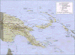
Calibrated for FSMap, but scanned images can be used in other map software, such as FSM Moving Map (FSMMM) by Rana Hossain. Chart source: Topographic Maps U.S. Army Map Service, Series T504, original scale 1:250,000, date 1964-. Courtesy of the University of Texas Libraries, The University of Texas at Austin. Missing: I could not find equivalent charts for New Britain; for this island, a lower-quality chart is included.
| Filename: | Papua_New_Guinea_Charts_2_of_3.zip |
| License: | Freeware |
| Added: | 7th May 2010, 10:45:02 |
| Downloads: | 795 |
| Author: | David Wilson-Okamura |
| Size: | 34.63 MB |
| Category: Navigation and ATC - Navigation | |
| Papua New Guinea charts 1 of 3 |
|
Images related to this file:
File Description:

Calibrated for FSMap, but scanned images can be used in other map software, such as FSM Moving Map (FSMMM) by Rana Hossain. Chart source: Topographic Maps U.S. Army Map Service, Series T504, original scale 1:250,000, date 1964-. Courtesy of the University of Texas Libraries, The University of Texas at Austin. Missing: I could not find equivalent charts for New Britain; for this island, a lower-quality chart is included.
| Filename: | Papua_New_Guinea_charts_1_of_3.zip |
| License: | Freeware |
| Added: | 5th June 2010, 03:40:04 |
| Downloads: | 1,213 |
| Author: | David Wilson-Okamura |
| Size: | 34.25 MB |
| Category: Flight Simulator 2004 - Scenery | |
| Tiksi bay, Russia (as it appears before 1940). |
|
Images related to this file:
File Description:
MSFS2004 scenery: Tiksi bay (as it appears before 1940) - settlement in Bulunsky Ulus of the Sakha Republic, Russia - situated on the Arctic Ocean coast. Freeware (c) 2009 Alexander Belov.
This scenery represents the Tiksi bay in the late of 1930-th years. It includes Tiksi airstrip and seaplane mooring positions, Tiksi polar station and Muostakh Island polar staton. Also Tiksi seaport, Tiksi and Sogo villages are presented.
| Filename: | Tiksi_bay_Russia_as_it_appears_before_1940.zip |
| License: | Freeware, limited distribution |
| Added: | 31st May 2010, 12:57:13 |
| Downloads: | 189 |
| Author: | Alexander Belov |
| Size: | 3.12 MB |
| Category: Flight Simulator 2004 - AI Flight Plans | |
| Airlines of Tasmania and Par Avion - amended |
|
Images related to this file:
File Description:

The following flightplans are to accompany my recent repaints of the Tasmanian services, Airline of Tasmania and ParAvion. They are in raw text format, and should be compiled for FS2004 using Traffic Tools. AFCADs are enclosed for fields lacking them from other sources.
THESE ARE CORRECTED PLANS AS OF 15 Nov 2011 due to an overlooked miscode of Cape Barren Island as YCBN, when it should have been YCBI.
| Filename: | Airlines_of_Tasmania_and_Par_Avion__amended.zip |
| License: | Freeware, limited distribution |
| Added: | 15th November 2011, 19:16:56 |
| Downloads: | 458 |
| Author: | John Burford |
| Size: | 90.69 KB |
| Category: Flight Simulator 2004 - Scenery | |
| McCord's Landing |
|
File Description:
McCord's Landing is a small 1000' dirt strip located on Kodiak Island. This is a land strip only, and has no lake facilities. There is water nearby if you choose to hike to the cabins. At McCord's cabin, there is a radio for emergencies. Watch your approaches from either direction, as there are some good size trees that make it a little tight. Have fun. Tight bush is back!
| Filename: | McCords_Landing.zip |
| License: | Freeware, limited distribution |
| Added: | 16th December 2003, 01:12:45 |
| Downloads: | 2,790 |
| Author: | Don Moser - Alaska By Don |
| Size: | 769.79 KB |
© 2001-2026 AVSIM Online
All Rights Reserved
Privacy Policy |