
Where Flight Simulation Enthusiasts Gather from Around the World!
AVSIM Library - Search Results

| Category: Flight Simulator 2004 - Original Aircraft | |
| Perry Institute Douglas DC3 |

|
File Description:
FS2004 Original Aircraft DC3 Perry Institute
Lee Stocking Island (See myxe9.zip) - For
the photo real island scenery. King Air
forward panel with DC3 cabin views giving
full autopilot features!!!Brakes have been
tweaked giving better ground steering and
stopping. Idle throttle set back to 750rpm.
Features full autopilot. Complete with
Perry Marine logos. Special thanks to Perry
Marine for their full cooperation. You see
them on Explorer and Discovery Channel.
Modified from default DC3.
Unzip directly into your FS9 aircraft folder!
See readme. WATCH FOR REPAINTS IN REPAINT SECTION.
Featured in the Abacus Publishing Gallery Oct 6, 2003!
| Filename: | Perry_Institute_Douglas_DC3.zip |
| License: | Freeware |
| Added: | 7th October 2003, 23:31:12 |
| Downloads: | 7,352 |
| Author: | jimmy R martin |
| Size: | 17.86 MB |
| Category: Flight Simulator X - Scenery | |
| Caribbean SeaPlane Tours, Bahamas |
|
File Description:
Part 3 of a 5 part series cover the Caribbean with custom airports and Seaplane Docks. "Caribbean SeaPlane Tours, Florida Operations" and Caribbean SeaPlane Tours, Caribbe West" are required for the scenery to display correctly. Please read the "Read-Me" files of all sceneries for installation information and hints. This scenery pack includes the following airports and seaplane docks: The airports - Nassau International, Walker's Cay, Deep Water Cay, Grand Bahamas International, Spanish Cay, Treasure Cay, Marsh Harbor Airport, Castaway Cay, Little Whale Cay, Exuma International, Hog Cay, Arthur's Town, Cutlass Bay, Rum Cay, Deadman's Cay, Duncan Town, Colonel Hill, Pittstown Point, Parrot Cay, Pine Cay, Conch Bay, Salt Cay, Mayaguna Island and a hidden Smuggler's scenery near Crooked Island. SeaPlane Docks - Nassau Lakeside, Nassau Oceanside, Paradise Island, Walker's Cay, Grand Bahamas, Treasure Cay, Castaway Cay, Hog Cay, Cutlass Bay, Rum Cay, Deadman's Cay, Parrot Cay, Pine Cay, Conch Bay, and Salt Cay. There are navigational aids included....Make sure you read the "Read-Me" File!
| Filename: | Caribbean_SeaPlane_Tours_Bahamas.zip |
| License: | Freeware, limited distribution |
| Added: | 24th November 2007, 17:16:16 |
| Downloads: | 5,457 |
| Author: | Chris Carel |
| Size: | 47.12 MB |
| Category: Flight Simulator 2004 - Scenery | |
| Canlaon Volcano Eruption Scenery |
|
File Description:
Canlaon Volcano is located at the center of Negros Island,Philippines.The twin-peaked massif of Canlaon Volcano (aka Mt. Kanlaon) rises 2,465 meters above the island of Negros just 40-km southwest of the capital Bacolod.This file will add the crater to Canlaon Volcano and will enhance the Landclass surrounding the crater.The crater is real with water.This also adds Visual Effects such as steam,volcanic ashes and lava that will erupt every now and then.Ash falls will fall in the vulnerable surrounding villages of Pula, Malaiba, and Lumanao.The last volcanic activity of Canlaon Volcano recorded by Phivolcs was on June 1-18,2003.
Fly from Bacolod City(RPVB)to Tagbilaran City(RPVT)or Mactan(RPVM) and pass through the highest point of the Island of Negros and behold the beauty of the Canlaon Volcano eruption.
Special steam,ash,and lava effects are visible at daytime and at nighttime.The new Philippine Mesh by Jacques Marie is recommended for achieving realistic topography.You may find it here at avsim,too.
| Filename: | Canlaon_Volcano_Eruption_Scenery.zip |
| License: | Freeware |
| Added: | 10th December 2003, 22:41:38 |
| Downloads: | 3,876 |
| Author: | Ver Walter L. Gulfan |
| Size: | 5.04 KB |
| Category: Flight Simulator 2004 - Scenery | |
| Campbell River CAE3 in BC Canada, textures and revised AI with Beaver aircraft |
|
Images related to this file:
File Description:
Campbell River CAE3 float base is in the middle of the eastern shore of Vancouver Island, six miles from the airport of the same name and where the channel between island and coast narrows down. Coril Air and Vancouver Island Air are both based there, but any number of other company planes can be seen on a daily basis, for instance Harbour Air which runs a regular service from Vancouver. This post provides all the textures required for the original post (some were missing, as I was told recently after some years had passed) plus a revised traffic file for Campbell River which has Beaver float planes flying between Campbell River and Vancouver Harbour. The Beaver planes are included, with permission, from the payware Alaska scenery by FSAddon. The layout of the dock moorings has been revised and the AFCAD included here replaces the one previously provided. The date of the scenery is around 2010, before a lot of the holiday trailers had been removed.
| Filename: | Campbell_River_CAE3_in_BC_Canada_textures_and_revi.zip |
| License: | Freeware, limited distribution |
| Added: | 19th November 2018, 18:06:42 |
| Downloads: | 248 |
| Author: | Roger Wensley |
| Size: | 7.68 MB |
| Category: Flight Simulator 2004 - AFCAD Files | |
| King County International (Boeing Field - KBFI) |
|
File Description:
King County International Airport is located 5 miles south of downtown Seattle and has the distinction of being the Boeing Company's final test site for the 737, 757, and 777 aircraft. Flight plans are included for 14 aircraft undergoing final tests prior to delivery to their respective airlines. Each aircraft will fly Monday through Friday for flights of approximately 3-1/2 hours. Since FS9 doesn't support flights that depart and arrive at the same airport, I've added a waypoint where the a/c can stop over for 15 minutes. The stopover is at Annette Island, Alaska, and I've included an AFCAD for an upgraded Annette Island "International" airport that, of course, doesn't really exist. If you wish to visit Annette Island International, there are runways equipped with the latest in ILS instrumentation. See the additional documentation I've included in the READ MEs. Commercial flights from Boeing Field are also provided by Helijet and San Juan Airlines.
| Filename: | King_County_International_Boeing_Field__KBFI.zip |
| License: | Freeware |
| Added: | 15th March 2004, 06:30:36 |
| Downloads: | 4,179 |
| Author: | Steve Lewis |
| Size: | 637.02 KB |
| Category: Flight Simulator X - Scenery | |
| Chatham Islands for Vector Land Class New Zealand |
|
Images related to this file:
File Description:
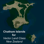
This project is a modified version of the Chatham_Islands.zip project which allows my landclass and airports to work seamlessly with the free Chatham Islands scenery available from Vector Land Class New Zealand. This package allows the user to switch back and forth easily between the different scenery combinations and also provides standalone Chatham and Pitt Island airports which can be used with the Vector Land Class (VLC) scenery on its own. It also allows the user to take advantage of the 15m terrain mesh and added water detail that comes with the VLC scenery. A modified Pitt Island AI runway is also included that is compatible with the 15m mesh. Chatham Islands/Tuuta Airport (NZCI), Napier (NZNR), and the Pitt Island Airstrip (NZPI) are included here. Scenery was created using Airport Design Editor X v1.47.07, SBuilderX 3.13, and the FSX Object Placement Tool. Scenery objects were added and modified from stock FSX scenery to resemble as closely as possible the actual airports.
| Filename: | Chatham_Islands_for_Vector_Land_Class_New_Zealand.zip |
| License: | Freeware |
| Added: | 15th July 2011, 21:54:43 |
| Downloads: | 931 |
| Author: | Carlyle Sharpe |
| Size: | 3.78 MB |
| Category: Flight Simulator 2004 - Scenery | |
| Gjoa Haven CYHK, on King William Island, Nunavut, Canada, |
|
Images related to this file:
File Description:
Gjoa Haven is a village of 1,200 or so inhabitants at N 68 38 W 95 51 on the southeast corner of King William Island, around 155 miles north of the Arctic Circle. It's Inuit name is Uqsuqtuuq; the Gjoa Haven name was given by the Norwegian explorer Roald Amundsen when he spent two years there from 1903 to 1905 during his exploration of the northwest passage from east to west. His boat was called Gjoa and the cove was named Gjoa Harbour, in Norwegian. The village has been added in this scenery with approximately the right shape; though the coastline with Ultimate Terrain does have the small cove that serves as a harbor the coast shape is wrong. The airfield runway is 4,400 feet of gravel 100 feet wide at 154 feet above sea level. There is no LL100 available, only JetA1, delivered once a year by ship along with all the other requirements of the town. There is also a nearby CAM-B remotely operated defence radar station with its three protective domes. The old terminal building is still there, albeit repainted and spruced up, along with the far larger and newer one alongside it.
One of the screen shots shows Gjoa Haven as it appears for at least 8 months of the year, with snow on the ground and sea ice all around. If you want the ice then download my recent post of All Canada frozen lakes, rivers, and the northern seas, reversible with an untick in the FS scenery library.
| Filename: | Gjoa_Haven_CYHK_on_King_William_Island_Nunavut_Can.zip |
| License: | Freeware, limited distribution |
| Added: | 19th February 2011, 15:42:51 |
| Downloads: | 550 |
| Author: | Roger Wensley |
| Size: | 2.68 MB |
| Category: Flight Simulator X - Scenery | |
| YLEA Leeman, Western Australia (Snag Island) airstrip and town |
|
File Description:
YLEA Leeman - formerley Snag Island is a tiny fishing village which is ideal for fishermen and holiday makers eager to get away from the more commercialised centres. Calling itself the 'Home of Western Australia's Dhufish' the settlement boasts huge and dramatic white sand dunes, good beach and offshore fishing, safe beaches for surfing, swimming and sailboarding, and superb displays of wildflowers in the spring. Leeman is home to a crayfish (lobster) fishing fleet which plies the fishing grounds off the coast in the season. The industry developed in the 1950s and has since become one of the most important on the Central West coast. It is also a dormitory suburb for the nearby sand mining town of Eneabba. REQUIRES Blencowe_LibraryKit.zip
REQUIRES blencowe_librarykit_309494.zip (Available HERE)
| Filename: | YLEA_Leeman_Western_Australia_Snag_Island_airstrip.zip |
| License: | Freeware |
| Added: | 28th February 2013, 13:54:58 |
| Downloads: | 229 |
| Author: | Alan Blencowe |
| Size: | 1.39 MB |
| Category: Flight Simulator X - Scenery | |
| KPVD, T. F. Green State Airport, Providence, Rhode Island |
|
Images related to this file:
File Description:
Complete new setup with ADE, from satellite images. T.F. Green Airport is 6 miles south of Providence. It is a public international airport, categorized by the FAA as a small hub primary commercial service facility.
| Filename: | KPVD_T_F_Green_State_Airport_Providence_Rhode_Isla.zip |
| License: | Freeware |
| Added: | 21st November 2017, 22:44:01 |
| Downloads: | 540 |
| Author: | Tim van Ringen |
| Size: | 829.15 KB |
| Category: Flight Simulator 2004 - Aircraft Repaints, Textures and Modifications | |
| Rhode Island ANG (143rd AW) Lockheed C-130H Hercules |
|
File Description:
Lockheed C-130H Hercules of the Rhode Island Air National Guard, 143rd Airlift Wing, utilizing Mike Stone's C-130H aircraft; and painted in 16-bit textures. This is a delight to fly, and is polygon-low enough to work as an AI aircraft. Textures only, requires base pack available here on AVSIM or Mike Stone's website. Aircraft repaint by Michael Pearson ([email protected]).
| Filename: | Rhode_Island_ANG_143rd_AW_Lockheed_C130H_Hercules.zip |
| License: | Freeware |
| Added: | 14th November 2004, 23:25:59 |
| Downloads: | 287 |
| Author: | Michael Pearson |
| Size: | 1.13 MB |
© 2001-2026 AVSIM Online
All Rights Reserved
Privacy Policy |