
Where Flight Simulation Enthusiasts Gather from Around the World!
AVSIM Library - Search Results

| Category: Flight Simulator 2004 - AFCAD Files | |
| MATVA Pacific |

|
File Description:
Afcad2 files for more of the Pacific airfields used by ourselves. These Afcads are designed for FS2004 default airfields only. While most of them add more gates etc to the default airfields some of them are required to allow AI aircraft to operate from/to them as there are no landing facilities. Airfields included are Nauru (ANAU), Vanuatu airfields Bauerfield (NVVV), White Grass (NVVW), Sangafa (NVSE) and Santo Pekoa (NVSS). New Caledonian Group, Tontouta (NWWW), Ounaham (NWWL), La Roche Aero (NWWR), Ouloup (NWWV) and Moue (NWWE). I have also included Maroochydore Airfield (YBMC). I haven't made any changes to the airfield but I have moved the ATIS frequency as FS9 has it sharing/colliding with Brisbane ATC making it difficult to contact/answer Brisbane. Especially when approaching from the East.
| Filename: | MATVA_Pacific.zip |
| License: | Freeware |
| Added: | 13th October 2005, 23:00:30 |
| Downloads: | 2,008 |
| Author: | Louie Maclennan MATVA |
| Size: | 20.6 KB |
| Category: Flight Simulator 2004 - Scenery | |
| North Manitoba Airfields 20# in Canada |
|
Images related to this file:
File Description:
These are 20 airfields in north Manitoba, Canada. They were all previously posted individually But not on Avsim. There is a screenshot of Google Earth showing their names and locations amid other airfields. "Lodge" indicates the fact that there is a fishing lodge and airfield at that location but that I have no information to enable me to make the scenery. There are also some airfields that I downloaded years ago and are part of my FS9 set up, such as Flin Flon. There is AI with the supply flights that are vital for these isolated outposts. Gillam is a northern airfield that is connected to the rest of Canada by a railroad that continues north to Churchill Manitoba on the Hudson Bay coast and is used for grain exports during the ice-free summer months. A large number of the supply flights originate from Gillam. You may wonder about the numbers of fuel tanks at these airfields. These are not for the airfield use, they are for the settlement to be able to generate electricity and also to provide heating in the winter. If you find an error email me please, and note that my email address has been changed to rogwens at Gmail dot com.
| Filename: | North_Manitoba_Airfields_20_in_Canada.zip |
| License: | Freeware, limited distribution |
| Added: | 7th April 2021, 17:09:34 |
| Downloads: | 80 |
| Author: | Roger Wensley |
| Size: | 35.99 MB |
| Category: Flight Simulator 2004 - Scenery | |
| Northern Canada Mining CYOA & CHB3 in Canada |
|
Images related to this file:
File Description:
These are two airfields in northern Canada, serving two mining operations. The furthest north is Hope Bay CHB3 in Nunavut. It is in a sheltered inlet less than 3 miles from the northern mainland coast and around 65 miles southwest of Cambridge Bay. The owner is Hope Bay Mining Ltd, and their operation mines gold out of a tunnel rather than open cast. The airfield is incorporated into the road that leads north to the sea; traffic is halted by traffic lights when a flight is expected. The runway is 3,000 feet of gravel aligned 01-19 and with PAPI at both ends.
The second airfield serves the Ekati diamond mine and is some 265 miles southwest of Hope Bay, in the Northwest Territories. Ekati was the first Canadian diamond mine and is 195 miles northeast of Yellowknife and less than 20 miles north of a later mine, Diavik (by Sid and Pete). CYOA reflects the relative value of the two mining operations and is far better equipped than Hope Bay. It can be described as an airport while Hope Bay remains an airfield. The runway is 6,400 feet of gravel aligned 36-18 with PAPI and strobe approach lights at both ends. The scale of the mining operation can only be described as huge.
| Filename: | Northern_Canada_Mining_CYOA__CHB3_in_Canada.zip |
| License: | Freeware, limited distribution |
| Added: | 11th August 2018, 22:59:06 |
| Downloads: | 215 |
| Author: | Roger Wensley |
| Size: | 8.24 MB |
| Category: Flight Simulator 2004 - Scenery | |
| Silver City CFQ5 in Yukon Territory Canada |
|
Images related to this file:
File Description:
Silver City is a ghost town in the Yukon Territory, Canada, amid the Rocky Mountains and around 35 miles northwest of Haines Junction. It is on the southern end of Kluane Lake and in the Kluane National Park and this probably explains it's (minimal) survival after what appears to have been the shutdown of mining for silver. There is little information readily available. The date of this scenery is, as usual, around 2010. There was no recent regular service by Yukon Air North or any other airline, and the primary user of the airfield adjacent to the lake is a company called Icefield Discovery Tours. Their activity is probably very similar to the company at Haines Junction and involves trips to the National Park amid mountains and glaciers. There is also another organisation at the airfield, the Kluane Lake Research Station of the Arctic Institute. They have four buildings there but it is unclear how much aerial activity they generate, or if in fact they fly at all for their work. The runway is 3,000 feet of unlit gravel, aligned north-south. This post will be followed by Burwash, which is at the far northwestern end of the lake. There is no video of the Silver City airfield on Youtube, and it is not the most exciting airfield in the world, but the location is enough in real life for a visit to be made. On YouTube there is a series of posts by Angle of Attack showing the preparation and then the flight of an old Cessna 172 from Homer to Oshkosh for the installation of modern instruments. Interesting for me as they visit or fly over airfields I have made: Homer, Merrill, Tok Junction, Burwash, Silver City, Haines Junction, Watson Lake, Fort Nelson, and Grande Prairie. But they fly in the winter so it all looks very different.
| Filename: | Silver_City_CFQ5_in_Yukon_Territory_Canada.zip |
| License: | Freeware, limited distribution |
| Added: | 22nd January 2022, 21:57:41 |
| Downloads: | 95 |
| Author: | Roger Wensley |
| Size: | 9.86 MB |
| Category: Flight Simulator 2004 - Scenery | |
| Nanisivik CYSR and Arctic Bay CJX7 in Nunavut, Canada |
|
Images related to this file:
File Description:
Nanisivik is an airfield in the north of Baffin Island, 470 miles north of the Arctic circle. It was built to service a zinc and lead mine that was opened in 1976 as Canada's first Arctic mine, now closed and dismantled. The deep water Strathcona Sound has been ear-marked by the Canadian government for development as a naval base, so I have left the large ore storage shed and the jetty in place. The airfield is at 2,106 feet on the top of the Borden Peninsula hills with a lighted 6,400 feet of 150 feet wide gravel runway runway aligned 11/29. There is a terminal and other maintenance buildings, and First Air have a building there from when the mine generated a lot of traffic and jets were used. Arctic Bay is a village 11 miles west of Nanisivik airfield with a population of around 690 which also uses the Nanisivik airfield. There is another gravel strip much closer to the village that is called Arctic Bay CJX7, but this is smaller with only 1,500' of 50' wide gravel and has no facilities of any sort. The village is partly dependent on visiting sports hunters and other limited tourist visits. At almost 73 degrees north the average year will have only four or even three months where the average high is above freezing. The buildings on the field have been modelled specifically for this scenery, and as in real life there is only JetA available. The AI visiting aircraft are a Kenn Borek Twin Otter and a First Air 42-300. As Nanisivik is in the "Northern Domestic Airspace" the runway is signed in "true" bearings and not magnetic as magnetic compasses become unreliable close to the magnetic pole.
| Filename: | Nanisivik_CYSR_and_Arctic_Bay_CJX7_in_Nunavut_Cana.zip |
| License: | Freeware, limited distribution |
| Added: | 28th May 2011, 19:59:18 |
| Downloads: | 493 |
| Author: | Roger Wensley |
| Size: | 2.64 MB |
| Category: Flight Simulator 2004 - Scenery | |
| Airstrips of Austria |
|
Images related to this file:
File Description:

Probably the last of my Airstrips of Western Europe project, herewith 30+ sceneries for smaller airfields in Austria, a particularly scenic area of Europe, many of which are not included in FS2004, each enhanced with taxiways, parking spaces, buildings etc. and aprons as appropriate, to further facilitate the generation of lightweight AI traffic in the area, without overloading the more major airfields.
Again, there's no photo-realism here, just a selection of basic 'generic' buildings, more or less accurately sized and placed to reflect the airfield layout as seen on on-line satellite imagery and aerial photography. These buildings have minimal effect on frame-rates, so are ideal for this kind of job. The airfields are aligned as well as possible with the roads etc. in UT Europe and the Genesis Europe mesh, but should mostly be fine in a default installation or other configuration.
As before, the files for each airfield can be easily identified by the ICAO code, even if the airfield names vary slightly, so you can pick and choose and mix and match to suit any sceneries you already have, should you so wish. There is no requirement for any other download. Each airfield will exist as a stand-alone entity should you only want a few of them.
Very few basic library objects are used ... you can add "eye-candy" to suit your own taste should you wish, or just leave them as vague shapes in the scenery that can put a few more small aircraft into the air. As with other airfields in this series, now these are "ai-activated" you might expect to see the occasional little aircraft turn up at some of them if you've got any third-party traffic installed.
| Filename: | Airstrips_of_Austria.zip |
| License: | Freeware |
| Added: | 26th April 2025, 13:59:32 |
| Downloads: | 82 |
| Author: | Chris Eve |
| Size: | 1.04 MB |
| Category: Flight Simulator X - Aircraft Repaints, Textures and Modifications | |
| Supermarine Spitfire Mk. IIb (MH434) |
|
Images related to this file:
File Description:
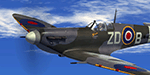
This repaint is for the A2A Wings of Power III Spitfire Mk2b, representing the MkIX MH434, the personal aircraft of South African fighter ace Flt Lt Henry Lardner-Burke DFC.
Today, MH 434 is based at the historic airfield, Duxford (now home to the Imperial War Museum), where it is maintained and operated by the Old Flying Machine Company (OFMC).
| Filename: | Supermarine_Spitfire_Mk_IIb_MH434.zip |
| License: | Freeware |
| Added: | 2nd September 2014, 13:36:10 |
| Downloads: | 226 |
| Author: | Steve Landau |
| Size: | 26.71 MB |
| Category: Prepar3D V1-4 - Aircraft Repaints, Textures and Modifications | |
| North American P-51D 506th FG #539 'Lil Ole Meanie II' |
|
Images related to this file:
File Description:
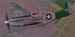
This folder contains a repaint for the A2A WoP3 P-51D Mustang (with AccuSim), in the colors of P-51D-25 44-73379, 457th FS/506 FG, #539 'Lil Ole Meanie II" as flown by lts Hetland and Hinkle. It was based at Airfield No 3, Iwo Jima, Summer 1945. Repaint by Jan Kees Blom, based on the paintkit by A2A.
| Filename: | North_American_P51D_506th_FG_539_Lil_Ole_Meanie_II.zip |
| License: | Freeware |
| Added: | 1st November 2018, 22:13:38 |
| Downloads: | 61 |
| Author: | Jan Kees Blom |
| Size: | 11.72 MB |
| Category: Prepar3D V1-4 - Aircraft Repaints, Textures and Modifications | |
| Consolidated B-24J Liberator (#133) 307th BG "This is it!" |
|
Images related to this file:
File Description:
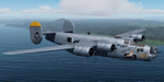
This folder contains a repaint for the Consolidated B-24J by Flight Replicas, adapted for use in P3Dv5. It shows B-24J-195-C0 44-41133 'This is it!', which flew with the 372nd BS/ 307th BG, based at Kornasoren Airfield, Noemfoor Island, Schouten Islands, Indonesia in November 1944. Repaint by Jan Kees Blom, based on the paintkit by Flight Replicas.
| Filename: | Consolidated_B24J_Liberator_133_307th_BG_This_is_i.zip |
| License: | Freeware |
| Added: | 25th April 2020, 17:28:07 |
| Downloads: | 48 |
| Author: | Jan Kees Blom |
| Size: | 54.3 MB |
| Category: Prepar3D V1-4 - Aircraft Repaints, Textures and Modifications | |
| Vans RV7(G-DMBO) |
|
Images related to this file:
File Description:
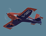
Built at home in the back garden, it had to be craned over the roof of the house before he could take it to an airfield! Colin Goodwin's RV7. The DMBO registration is a homage to his father or, more specifically, the flying elephant that was painted on the side of his Wellington bomber. Textures only for Bay Tower's RV7
| Filename: | Vans_RV7GDMBO.zip |
| License: | Freeware |
| Added: | 10th July 2020, 21:31:03 |
| Downloads: | 32 |
| Author: | Ron Attwood |
| Size: | 4.49 MB |
© 2001-2026 AVSIM Online
All Rights Reserved
Privacy Policy |