
Where Flight Simulation Enthusiasts Gather from Around the World!
AVSIM Library - Search Results

| Category: Flight Simulator X - Scenery | |
| Alf's UK airfields volume 26-Lashenden v2 |

|
Images related to this file:
File Description:
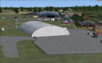
Lashenden EGKH is a grass airfield just SE of Headcorn in Kent. Both light aircraft movements and freefall parachuting take place and there is a museum on site. This is a new version of the one I did some years ago and uses photo textures on the buildings and includes the new large hangar.
| Filename: | Alfs_UK_airfields_volume_26Lashenden_v2.zip |
| License: | Freeware |
| Added: | 26th February 2013, 20:39:16 |
| Downloads: | 1,217 |
| Author: | Alf Denham |
| Size: | 13.76 MB |
| Category: Flight Simulator 2002 - Scenery | |
| Scenery Saxonia V23 |
|
File Description:
FS2002 scenery Saxonia/Germany V23.
The archive contains the airports Leipzig-Halle (EDDP),Dresden (EDDC),
the airfield Langhennersdorf (EDOH) and much more with many vfr-objects
arround, afcad-files, LandClass and AI-traffic. The archive comes with a
self installing wizard by ClickTeam a documentation in pdf and much more
information at www.edoh.de/fs/.
| Filename: | Scenery_Saxonia_V23.zip |
| License: | Freeware, limited distribution |
| Added: | 16th January 2003, 14:01:14 |
| Downloads: | 2,865 |
| Author: | Stefan Brand, Stefan Kaudelka, Helfried Miersch, Rolf-Uwe Hochmuth |
| Size: | 3.76 MB |
| Category: Flight Simulator X - Scenery | |
| LFLV - Vichy Charmeil |
|
Images related to this file:
File Description:
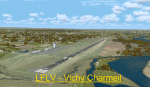
Scenery LFLV Vichy Charmeil V1.0 for FSX
Tested with SP2 Acceleration + UTX Europe.
V1.0: Initial version
This file modifies the airfield Vichy Charmeil in FSX. It was made with ADE (Airport Design Editor), SbuilderX and Whisplacer.
Thank you to the respective authors.
Vichy is a French commune in the Allier department in Auvergne region.
| Filename: | LFLV__Vichy_Charmeil.zip |
| License: | Freeware |
| Added: | 15th September 2010, 19:10:56 |
| Downloads: | 2,193 |
| Author: | Stephane Gouzon |
| Size: | 6.99 MB |
| Category: Flight Simulator X - Scenery | |
| Blue Canyon Wind Farm |
|
File Description:
Scenery adding the Blue Canyon Wind Farm (Phase 1) north of Lawton, Oklahoma with antimated windmills and upgrading the nearby Jennings Ranch and airfield (OL09). This scenery was created with Airport Design Editor, utilizes an antimated windmill model posted at the FS Developer Community by hcornea, and has been tested using Ultimate Terrain X.
| Filename: | Blue_Canyon_Wind_Farm.zip |
| License: | Freeware |
| Added: | 28th October 2008, 20:40:19 |
| Downloads: | 609 |
| Author: | Art Poole |
| Size: | 335.25 KB |
| Category: Flight Simulator 2004 - Scenery | |
| Nulato NUL in Alaska |
|
Images related to this file:
File Description:
Nulato is a small village on the west bank of the Yukon River, around 8 miles south of where the river turns from north-south to east-west, east being upstream towards the distant Fairbanks. The population is just under 300 and living from fishing and the land. During the late 1800's the village lived by the spin off from gold mining, such as supplying cut wood as fuel for the boats plying the Yukon River. In 1900 a measles epidemic cut the population down by a third, and in the early 1900's the gold mining moved to Nome and Fairbanks, with obvious results for local prosperity. The airfield is close by and has a gravel runway aligned 2-20 and just under 4,500 feet long. Apart from the airfield itself, and it's buildings, this scenery modifies the local land class, adds village buildings while reducing the village size to reality, and creates a new airfield background. Don't ask me about the odd arrangement of the airfield buildings, I have no idea why they are like that. Nulato is served by Wright Air from Fairbanks in the east and this is included in the AI. A note here about my scenery making. This is post number 508 and there will not be many more to follow this as I am almost at the end of the photos I either took or found for scenery purposes. There is a limit to what can be located online and I have already been making use of the little there is; eg Unalakleet. So, if you are near an airport (preferably Canadian or Alaskan) and have a camera..... Let me know.
| Filename: | Nulato_NUL_in_Alaska.zip |
| License: | Freeware, limited distribution |
| Added: | 25th August 2019, 17:34:25 |
| Downloads: | 103 |
| Author: | Roger Wensley |
| Size: | 3.05 MB |
| Category: Flight Simulator X - Scenery | |
| RAF Keevil |
|
File Description:
The airfield was built on a site previously ear-marked for the purpose in the mid-1930s. Consisting of 3 long concrete
runways the airfield was used by the Royal Air Force and the United States Army Air Forces Eighth and Ninth Air
Forces.
In 1942 Keevil airfield was provided to the USAAF and it was assigned USAAF designation 471 (KV). Squadrons based at
the unit transported military freight and supplies using C-47 and C-53 aircraft.
RAF Fighter Command use
Short Stirlings of Nos. 196 and 299 Squadrons RAF lining the runway at RAF Keevil on the evening of 5 June 1944 before
emplaning paratroops of the 5th Parachute Brigade Group for the invasion of Normandy With the departure of the
Americans, the RAF used Keevil beginning in March 1944 for 196 and 299 Squadron Short Stirling glider tugs of No. 38
Group RAF arrived followed by a large number of Horsa gliders, crewed by Army pilots of the Glider Pilot Regiment.
The RAF Stirling aircraft were crewed by RAF, RCAF, RAAF, RNZAF and SAAF personnel and were engaged in SOE and SAS
drops. largely in France, and in glider towing. Their involvement in the Normandy invasion of France and Operation
Market-Garden is well remembered by Keevil and Steeple Ashton villagers. Casualties of army and air force personnel
were heavy and a number of aircraft were lost.
With the end of military control, Keevil airfield is virtually complete with all of its runways, perimeter track and
many of the hardstands still in place. It is used occasionally for British Army and RAF exercises. The airfield is
still frequently used by the RAF for training purposes such as air drops and parachuting, the gate is always locked
and access is restricted to authorized key holders only. Ref ~ http://www.wdrcfc.org.uk/wp/about-2/clubrules/
Since 1992 it has been home to the Bannerdown Gliding Club, an RAF Gliding and Soaring Association Club, affiliated to
RAF Brize Norton since the closure of nearby RAF station at Lyneham. The airfield is also used as a motorsport circuit
for various events. It is also the home of the Warminster and District Radio Control flying club.
In September 1994 the Keevil Society, organised by Paul Vingoe, held a Commemorative Day to mark the 50th anniversary
of the D-Day and Arnhem operations and to dedicate a memorial to all who served at Keevil, especially those who flew
from there and lost their lives.
Source:Wikipedia
| Filename: | RAF_Keevil.zip |
| License: | Freeware |
| Added: | 5th February 2017, 19:55:43 |
| Downloads: | 174 |
| Author: | Terry Boissel |
| Size: | 24.39 KB |
| Category: Flight Simulator X - AFCAD Files | |
| SAVT-Almirante Marcos A. Zar Airport-Chubut Province, Argentina & SA34-Trelew Airfield |
|
File Description:
Almirante Marcos A. Zar Airport (Welsh: Almirante Marcos A. Zar Maes Awyr, Spanish: Aeropuerto Almirante Marcos A. Zar) (IATA: REL, ICAO: SAVT) is an airport in Chubut Province, Argentina, named after the Argentine Navy Admiral and
naval aviator Marcos Andres Zar. The airport serves the cities of Trelew and Rawson. Two airlines operate regularly to the airport, LADE and Aerolineas Argentinas, and in May 2009 the latter is supposed to start direct international
flights to Sao Paulo, Brazil.
Trelew Airfield (Spanish: Trelew Aeroparque ) (ICAO: SA34) is located in Trelew at Almirante Marcos A. Zar Airport neighbourhood.
This work is dedicate to Tiziano Fiori who lives in Trelew.
| Filename: | SAVTAlmirante_Marcos_A_Zar_AirportChubut_Province_.zip |
| License: | Freeware |
| Added: | 27th September 2012, 23:44:20 |
| Downloads: | 342 |
| Author: | Anwar Gonzalez |
| Size: | 142.92 KB |
| Category: Prepar3D V1-4 - Scenery | |
| ALDERNEY2019 (ORBX) Enhancements |
|
File Description:
REQUIRED FOR MOST OF THE ADDITIONS TO WORK IS - "S.O.D.E."--
Surf effects, Bird flocks, Smoke palls, Grass cutting tractors, 4 Static boats/ships (all vary with time and/or weather).
Also - Adjusted Airfield parking for "no pushback" and extra parking (G reg traffic flightplan coming soon)., Two fishing vessels routing from Alderney and back to harbour.
| Filename: | ALDERNEY2019_ORBX_Enhancements.zip |
| License: | Freeware, limited distribution |
| Added: | 28th December 2019, 19:51:57 |
| Downloads: | 276 |
| Author: | john watts |
| Size: | 290.16 KB |
| Category: Flight Simulator 2002 - Scenery | |
| People to Terrains Sceneries, Dijonnais, Tournus, Monaco, Algiers, Geneva |
|
Images related to this file:
File Description:
That series is adding varied people at G. Guichard FS2002 Terrains Sceneries, namely the Dijonnais' terrains, Tournus airfield, Monaco heliport, Algiers' Houari Boumediene and Geneva-Cointrin airports as contained in the darois.zip, tournus.zip, monaco.zip, houabou.zip, and geneve.zip files, respectively. Such files are adding a little more life to that sceneries. Comes with a French readme too. Freeeware
| Filename: | People_to_Terrains_Sceneries_Dijonnais_Tournus_Mon.zip |
| License: | Freeware |
| Added: | 30th March 2016, 08:40:40 |
| Downloads: | 39 |
| Author: | G. Guichard |
| Size: | 342.14 KB |
| Category: Flight Simulator X - Aircraft Repaints, Textures and Modifications | |
| Piper PA-24 Comanche (G-BAHJ) |
|
Images related to this file:
File Description:
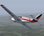
Previously PH-RED, G-BAHJ was re-registered in 1972. Built in 1960, she is owned by Keith Cooper and as far as I can tell is kept at Wellesbourne Mountford airfield (EGBW) in Warwickshire. That's Waricksheer for U.S. readers. :-)
Textures only for A2A's PA24 Comanche. Available from a dealer near you for only $49.99! A steal.
| Filename: | Piper_PA24_Comanche_GBAHJ.zip |
| License: | Freeware |
| Added: | 28th June 2015, 00:54:36 |
| Downloads: | 538 |
| Author: | Ron Attwood |
| Size: | 41.33 MB |
© 2001-2026 AVSIM Online
All Rights Reserved
Privacy Policy |