
Where Flight Simulation Enthusiasts Gather from Around the World!
AVSIM Library - Search Results

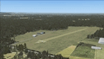
| Category: Flight Simulator 2004 - Scenery | |
| Moffet Federal Airfield (KNUQ) - Mountain View, California |

|
Images related to this file:
File Description:
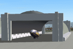
Moffet Federal Airfield (KNUQ) version 2. Now with open blimp hangar, improved models and texturing, and AI Goodyear blimp courtesy of David (Opa) Marshall and Bill Lyons. This is a complete scenery and no other downloads are required.
| Filename: | Moffet_Federal_Airfield_KNUQ__Mountain_View_Califo.zip |
| License: | Freeware |
| Added: | 2nd February 2010, 10:58:59 |
| Downloads: | 2,536 |
| Author: | John Stinstrom & David "Opa" Marshall |
| Size: | 6.65 MB |
| Category: Flight Simulator X - Scenery | |
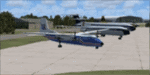
| KFLV - Sherman Army Airfield - Fort Leavenworth, KS |
|
Images related to this file:
File Description:

Re-upload. By request, here is an improved version of the stock Sherman Army Air Field. I added Military_Cargo, Military_Combat,and GA parking spaces. I removed and replaced most default buildings. Added roads, buildings, the control tower, static airplanes and vehicles. Added, removed, or adjusted taxiways and aprons as needed.
| Filename: | KFLV__Sherman_Army_Airfield__Fort_Leavenworth_KS.zip |
| License: | Freeware |
| Added: | 28th May 2010, 04:15:53 |
| Downloads: | 1,237 |
| Author: | Jim Cook |
| Size: | 5.19 KB |
| Category: Flight Simulator X - Scenery | |
| Arnot Power Station Airfield (FAAP), South Africa |
|
Images related to this file:
File Description:
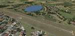
Arnot is situated at an altitude of 5580 ft. It's runway is 1158m long and only 9m wide. The airfield is owned by Escom, the sole producer of all the electricity used in South Africa. The airfield is limited to aircraft with a MAUW of 5700kg or less. The trees just short of the threshold of Runway 13 makes for an interesting approach and you better be sure about your take-off weight when taking off from Runway 31. Runway lights are also available.
Please install fsxWorx01.zip, fsxWorx02.zip and all the updates for these, before this scenery.
| Filename: | Arnot_Power_Station_Airfield_FAAP_South_Africa.zip |
| License: | Freeware |
| Added: | 2nd December 2012, 18:59:48 |
| Downloads: | 2,643 |
| Author: | Kobus van Wyk, Aeroworx |
| Size: | 7.48 MB |
| Category: Flight Simulator X - AFCAD Files | |
| SSMW - Ica Airfield - Peruibe, Sao Paulo - Brazil |
|
Images related to this file:
File Description:
This airfield is located in the city of Peruibe, State of Sao Paulo, Brazil. It has a runway (headboards 08-26) with about 600 m long, sandy, and operated exclusively for agricultural aircraft.
| Filename: | SSMW__Ica_Airfield__Peruibe_Sao_Paulo__Brazil.zip |
| License: | Freeware |
| Added: | 2nd December 2014, 00:01:15 |
| Downloads: | 125 |
| Author: | Wellington Silva de Farias |
| Size: | 27.75 KB |
| Category: Flight Simulator X - Scenery | |
| Duxford Airfield Scenery for FSX SP2/Acceleration |
|
Images related to this file:
File Description:
Scenery for Duxford Airfield, Cambridgeshire, UK, home of Imperial War Museum Duxford. This scenery includes almost all of the buildings, and ample parking for AI. It also includes flightplans to set up two resident dragon rapide aircraft and museum aircraft on the ramp. Many thanks to David Garwood for his help, and the use of his custom buildings. Further downloads are required-please see readme for details. Designed for the default scenery, feedback when it is used with products like UTX Europe, Justflight VFR or Genx would be appreciated.
| Filename: | Duxford_Airfield_Scenery_for_FSX_SP2Acceleration.zip |
| License: | Freeware, limited distribution |
| Added: | 11th April 2011, 05:49:28 |
| Downloads: | 1,477 |
| Author: | Tom Arnold |
| Size: | 933.86 KB |
| Category: Flight Simulator X - Scenery | |
| EDHO - Airfield Ahrenlohe, Schleswig-Holstein, North Germany |
|
File Description:
FSX-Scenery of Airfield Ahrenlohe, Schleswig-Holstein, North Germany
Small landing place NE of the mostly better known Uetersen/EDHE
Photorealistic underground from Google Earth mit Winter season and autogen.
| Filename: | EDHO__Airfield_Ahrenlohe_SchleswigHolstein_North_G.zip |
| License: | Freeware |
| Added: | 6th March 2008, 21:56:23 |
| Downloads: | 2,094 |
| Author: | Uwe Schweitzer |
| Size: | 2.25 MB |
| Category: Flight Simulator 2004 - Scenery | |
| Tongass Remote Airfield v2 - for Tongass Fjords |
|
Images related to this file:
File Description:
Tongass Remote Airfield v2 - for Tongass Fjords (FS9)
"Tongass Remote Airfield" v2 (RATR) Alaskan bush flying scenery (Fictitious).
This airstrip is for Flight Simulator 2004 and for the "Tongass Fjords" (FS9) addon by Holger Sandmann & Bill Womack; you must have "Tongass Fjords" (FS9) for this to work. Version 2 is a detailed, stand alone, remake of the first version, see PDF file.
Field history and description:
In the early days this area was well known to prospectors and hunters. A small mine was established and later abandoned. Around the late 40s a crew was contracted to clear a small landing area to gain easier access for hunters and campers. Due to the extreme remoteness of this area that clearing took several years. The last phase was the approach, clearing by hand a descending glide slope through just the tops of the tall trees. There is now just enough room for a very experienced pilot to get in and out of this field. The airfield is 26 miles north of Petersburg Alaska (PAPG). This is a tricky narrow approach with a left hand dogleg and then an immediate right hand dogleg turn just before the final approach. Not much time to set up your approach; also, it's a very short runway. For experienced pilots only, and make sure that your life insurance is up to date. Good luck.
| Filename: | Tongass_Remote_Airfield_v2__for_Tongass_Fjords.zip |
| License: | Freeware, limited distribution |
| Added: | 22nd March 2010, 13:16:16 |
| Downloads: | 626 |
| Author: | Jay Langham |
| Size: | 6.18 MB |
| Category: Flight Simulator X - Scenery | |
| Error update for Viborg airfield EKVB scenery |
|
File Description:
This is an update, that fix the error that effect file Campfire_3 gives, so just copy these 2 effects files into your FSX effect folder and overwrite the earlier files
| Filename: | Error_update_for_Viborg_airfield_EKVB_scenery.zip |
| License: | Freeware |
| Added: | 2nd June 2019, 16:14:48 |
| Downloads: | 148 |
| Author: | otto Knudsen |
| Size: | 2.66 KB |
| Category: Flight Simulator X - AFCAD Files | |
| LFFX - The Tournus-Cuisery Airfield - Burgundy, France |
|
Images related to this file:
File Description:
That freeware scenery for FSX represents the small, Tournus-Cuisery airfield (LFFX) in Burgundy, France, which is located between Chalon and Macon. Comes with a French readme too.
| Filename: | LFFX__The_TournusCuisery_Airfield__Burgundy_France.zip |
| License: | Freeware |
| Added: | 6th August 2014, 18:38:05 |
| Downloads: | 570 |
| Author: | Gerard Guichard |
| Size: | 307.75 KB |
| Category: Flight Simulator X - Scenery | |
| LFQF - Autun Bellevue (France) |
|
File Description:
Airfield Autun Bellevue LFQF (France - Saone-et-Loire) FSX AFCAD corrected - airport relocated to its real coordinates, compatible photorealistics scenes, compatible with any version FSX
| Filename: | LFQF__Autun_Bellevue_France.zip |
| License: | Freeware |
| Added: | 30th December 2011, 15:39:36 |
| Downloads: | 1,001 |
| Author: | Emmanuel Lucion |
| Size: | 2.91 MB |
© 2001-2026 AVSIM Online
All Rights Reserved
Privacy Policy |