
Where Flight Simulation Enthusiasts Gather from Around the World!
AVSIM Library - Search Results

| Category: Flight Simulator 2004 - Scenery | |
| St. George (KSGU) / Mesquite (67L), Utah/Nevada, Photo-Scenery (FS9 & FSX) |

|
Images related to this file:
File Description:
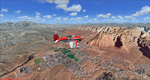
Covers the area between St. George, Utah and Mesquite, Nevada. To the north of St. George
the Pine Valley Mountains with their foothills of scenic red sandstone loom over the city.
St. George Municipal Airport (KSGU) is mostly used for general aviation but is also served by SkyWest Airlines
on behalf of Delta Connection. Because of it's location on a mesa this airport can't be expanded and so a new
airport is currently being built southeast of the city at the site of an abandoned airfield. The opening
is expected in 2011. To the south of the city make sure, you don't miss the Virgin River Gorge where the
Virgin River winds thru a long winding canyon in the transition zone between the red rocks of southern Utahs
Colorado Plateau and Nevadas Mojave Desert. Shortly afterwards you reach Mesquite which is situated just
west of the Arizona stateline. Like nearly all Nevada cities near the stateline Mesquite is home to several
Casinos. Mesquite Airport (67L) lies just north of the city.
High resolution versions of this scenery for FS9 and FSX (much sharper, but larger and multiple downloads)
are available at www.blueskyscenery.com/CNY_South3West6.html . The screenies are taken from the high-res versions,
so expect this version to be slightly more blurry. Thanks to Joop Mak for providing custom AFCADs that
correct airport layouts so that they align with the photo-textures! They are available at www.blueskyscenery.com/AFCADs.html .
YourDonation@Work: Dedicated to Werner, Ralf-Peter and Nels.
| Filename: | St_George_KSGU__Mesquite_67L_UtahNevada_PhotoScene.zip |
| License: | Freeware, limited distribution |
| Added: | 24th March 2010, 19:41:43 |
| Downloads: | 1,649 |
| Author: | Gottfried Razek - blueskyscenery.com |
| Size: | 95.58 MB |
| Category: Combat Flight Simulator 1 and 2 - Missions | |
| Missions for the USAF F-51D of Flight1 'Sabre Vs MiG' (CFS2) |
|
File Description:
Five missions for the USAF F-51D of the "Sabre Vs MiG"add-on of Fligh1.Included Scenery of the main Mustangs base in the Korean war: K-10 Chinhae and a revision of the DP file for the Yak-9.
The missions were acomplished in the first days of November 1950 and are quite veridical; geographical,coordinates, units, dates, airfield bases,meteo,squadrons, pilots,etc.
No real is the standard Yak-9 supplied by Fligh1. The aircraft paint represent a V-VS(Russian Air Force)
fighter with the typical Russian camouflage; actually no Yak-9 were operated with Russian insignias in
Korea. The planes, models Yak-9P and Yak-9U, were assigned to the KPAFAC(North Korean Air Force) and
flew by crews of this nacionality, his painting scheme was a Russian post-war light blue grey with the
KPAFAC roundels under of the wings and in fuselage sides.The pilots were rookies but some success was achieved: one USAF F-80C of the 36 FBS,was shot down the 19-Jul-1950 by one Yak-9(Actually the first Korean war victory of a one piston fighter over a Jet);B-29s,F-51s,F-82s, were others victories of the Yaks in the early phase of the Korean war.V-VS had operated with a few LA-11.I have planned a repaint of the Yak-9 with the real colours of the KPAFAC and eventually convert to flight.
| Filename: | Missions_for_the_USAF_F51D_of_Flight1_Sabre_Vs_MiG.zip |
| License: | Freeware |
| Added: | 6th February 2004, 15:01:51 |
| Downloads: | 360 |
| Author: | Daniel Nole |
| Size: | 116.29 KB |
| Category: Flight Simulator X - Aircraft Repaints, Textures and Modifications | |
| De Havilland DH89A Dragon Rapide - G-AHAG - Four Repaints |
|
Images related to this file:
File Description:

These four repaints are of G-AHAG from various times in her career. This is from the freeware Dave Garwood model of the DH89, an aircraft that I thoroughly recommend you to download if you have not.
G-AHAG was built in 1945 as one of 335 Dominies built by Loughborough based Brush Coachbuilders. She was owned by Blackburn aircraft of Brough. I have included one of its liveries from this spell in this package. She then did a spell at the original Scillonia airways, being painted in the livery promoting Scenic Flights, another one that I have included in this package. After Scillonia Airways ceased operations in 1969, she was sold and subsequently leased to The Army Parachuting Association. Here, she was painted in the orange livery included. However, there only appears to be one photo online of her in this livery, from 1975, after being unofficially written off, following an incident involving someone ending up in the radio bay after jumping from a Britten-Norman Islander above. I have used this photo as a basis for the livery, so it may be incorrect.
After a very lengthy rebuild of 30 years at Membury Airfield in Berkshire, she was repainted in a scheme based on the original Scillonia Airways livery. This is the fourth repaint included in this pack.
Repaint by Adam Loader
Model by Dave Garwood (Available for free download from Classic British Flight Sim and Avsim)
| Filename: | De_Havilland_DH89A_Dragon_Rapide__GAHAG__Four_Repa.zip |
| License: | Freeware, limited distribution |
| Added: | 15th June 2018, 00:41:49 |
| Downloads: | 180 |
| Author: | Adam Loader |
| Size: | 13.94 MB |
| Category: Flight Simulator 2004 - Scenery | |
| Repulse Bay CYUT in Nunavut Canada |
|
Images related to this file:
File Description:
This is a scenery that I started in 2013, temporarily abandoned when I found there was a fault in the coastline that reduced it all to straight lines, and then totally forgot about. Until now, when I discovered that while I had made the Repulse Bay terminal building I had mysteriously not made the scenery. Investigation revealed the reason why and here it is with a coastline that has been repaired to the extent that the fault allowed. Repulse Bay has a population of around 1,100 and since 2015 has been officially named Naujaat, the traditional Inuit name. It is located exactly on the arctic circle on the northern extension of the western side of Hudson Bay, in a large bay off the northern tip of Southampton Island. Coral Harbour is on the far side of the island, 180 miles to the south. The airfield is alongside the town and the coast, with the runway 3,400 feet of gravel with PAPI at both ends, aligned 161T-341T with "T" standing for true as opposed to the unreliable magnetic bearing this far north. The regular scheduled flights are by Air Baffin (an Air Nunavut subsiduary), connecting to Iqaluit some 550 miles to the east. The helicopters are there in the summer with their own fuel in drums around their own parking apron. They land directly on the apron, which cannot be replicated in AI, so they are present only as parked choppers and not flying ones.
| Filename: | Repulse_Bay_CYUT_in_Nunavut_Canada.zip |
| License: | Freeware, limited distribution |
| Added: | 6th September 2018, 00:34:38 |
| Downloads: | 179 |
| Author: | Roger Wensley |
| Size: | 7.87 MB |
| Category: Flight Simulator 2004 - Scenery | |
| RAF Upper Heyford EGUA 1955-1962 |
|
File Description:
EGUA RAF Upper Heyford 1955-1962
The airfield was originally built in 1918 by the Royal Air Force on land owned by New College Oxford, closed briefly after the end of the First World War and then re-opened in the 1920s. During the Second World War it was used by units of RAF Bomber Command but these were training rather than operational forces, even if aircraft of the 16th OTU (Operational Training Unit) may sometimes have taken part in bombing operations against the Third Reich. New runways were laid in 1942. During the Cold War Upper Heyford was chosen as one of the airfields used to operate bomber aircraft belonging to the US Strategic Air Command, and in 1950 the main runway was extended while new hardstandings were constructed for the bombers concerned. However, units were not stationed there permanently, but did Temporary Duty Assignments from their bases in the US. They included the 93rd Bomb Wing, 97th Air Refueling Squadron, 509th Air Refueling Squadron, 301st Bomb Wing, 8th Air Sea Rescue Squadron, 2nd Bomb Wing, 5th Bomb Wing Detachment, and the 22nd Bomb Wing. Aircraft included the B-50 Superfortress, (briefly) the B-36 Peacemaker, the B-47 and from 1960 the B-52. There were further significant developments after 1962 which fall outside the remit of this scenery, Upper Heyford being finally returned to the British Ministry of Defence in 1994 after the end of the Cold War.
| Filename: | RAF_Upper_Heyford_EGUA_19551962.zip |
| License: | Freeware |
| Added: | 7th October 2022, 03:40:20 |
| Downloads: | 152 |
| Author: | Al Von Pingel, Ken Lawson |
| Size: | 42.75 MB |
| Category: Flight Simulator 2004 - Scenery | |
| Squamish CYSE in British Columbia Canada |
|
Images related to this file:
File Description:
Squamish is a town with a population of just under 20,000, located at the northern end of Howe Sound where the Squamish River reaches the sea. Howe Sound is 25 miles deep and around 10 miles northwest of downtown Vancouver. It was for years based on the surrounding timber and a pulp mill, but with the closure of the saw and pulp mills now is more tourist oriented and the escape for Vancouver residents looking for (relative) peace and quiet. The runway is 2,400 feet of asphalt aligned 14-32. The buildings are built on differing levels of terrain, and the taxiways are sloped access ramps between the levels. This, of course, cannot be replicated in FS9, but it explains what at first sight appears to be a strange layout. The buildings are fairly well replicated. This is not an airport, it is an airfield meant for summer use as there is no lighting of any sort for runway or taxiways. The AI includes both GA and the helicopter flights by the two companies with bases at Squamish, Black Tusk and Blackcomb, the latter having several bases in this area with a HQ in Whistler. If you have the Vancouver scenery by FSAddon then you will need to move some of their bgl's aside; there are screenshots so that you can see which ones I have relocated. The UT settings are optional; I have been asked for my personal preferences. If you find a defect, email me.
| Filename: | Squamish_CYSE_in_British_Columbia_Canada.zip |
| License: | Freeware, limited distribution |
| Added: | 16th November 2020, 19:15:12 |
| Downloads: | 121 |
| Author: | Roger Wensley |
| Size: | 15.9 MB |
| Category: Flight Simulator 2004 - Scenery | |
| Ulukhaktok (Holman) CYHI in the Northwest Territories, Canada |
|
Images related to this file:
File Description:
Ulukhaktok (Holman) is an airfield on the west side of Victoria Island, off the northern coast of Canada. It is 320 miles west of Cambridge Bay (and you should download and install the recent post of CYCB by Sid and Pete, as I use it for the AI included in this post) and around 400 miles east of Inuvik (my post of a few months ago). It has been officially called Ulukhaktok since 2006, and before that it's name was Holman.
The village of Ulukhaktok has been placed around the bay and is approximately the right shape; it houses some 460 people who used to rely solely on hunting and fishing. The village is close to 71 degrees north, and there are only four months of the year when the average high is above zero centigrade. The photograph with snow (and of course a frozen sea) is typical; for the frozen sea download my Frozen Rivers & Lakes post which will provide this. The buildings on the field have been modelled specifically for this scenery, and as in real life there is only JetA available. The AI visiting aircraft are an Aklak Air DC3 (based in Inuvik and operated by Kenn Borek Air) and a Canadian North Dash 8-100. Note that the runways are signed as "true" headings instead of magnetic; in the Canadian Northern Domestic Airspace all headings are given as true. Unfortunately FS9 doesn't accommodate this in ATC.
| Filename: | Ulukhaktok_Holman_CYHI_in_the_Northwest_Territorie.zip |
| License: | Freeware, limited distribution |
| Added: | 24th May 2011, 20:05:47 |
| Downloads: | 452 |
| Author: | Roger Wensley |
| Size: | 2.3 MB |
| Category: Prepar3D V1-4 - Aircraft Repaints, Textures and Modifications | |
| Douglas C-47 (X-1) Dutch Air Force |
|
Images related to this file:
File Description:
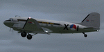
This folder contains a repaint for P3Dv4.5 PBR version of the Douglas C-47 by Manfred Jahn and colleagues in the colors of X-1 of the Dutch Air Force. The Dutch Air Force received her first Dakota's in 1952, although they owned one in 1946, but that crashed near Katwijk the same year and was destroyed. That one carried the registration X-1, but that is not the subject of my paint... The Air Force later leased one C-47 from the KLM, gave it the military registration X-2, but it kept its civil registration, PH-TBV, on the tail. Later they leased a few more, and clearly they liked them, because they bought a few more in 1952. The first one was taken on charge in 1952 and was numbered X-1 as depicted in this repaint. The makers badge with its construction number was missing however, and nobody seems to know where this aircraft came from. The logbook mentions the aircraft was 'found'. There was a rumour that the aircraft had been used by refugees from the east and landed at Valkenburg airfield without registration. About a year later, the aircraft made an emergency landing near Valkenburg after taking off for a relief flight for the flooded areas in the south of the Netherlands on 6 februari 1953 and was written off. Repaint by Jan Kees Blom for Manfred Jahn's C-47 for P3Dv4.5, with PBR, Rivet and bump detail by Ted (Tufun) Wolfgang."
| Filename: | Douglas_C47_X1_Dutch_Air_Force.zip |
| License: | Freeware |
| Added: | 26th January 2020, 17:55:48 |
| Downloads: | 152 |
| Author: | Jan Kees Blom |
| Size: | 25.1 MB |
| Category: Flight Simulator 2004 - Scenery | |
| Gjoa Haven CYHK, on King William Island, Nunavut, Canada, |
|
Images related to this file:
File Description:
Gjoa Haven is a village of 1,200 or so inhabitants at N 68 38 W 95 51 on the southeast corner of King William Island, around 155 miles north of the Arctic Circle. It's Inuit name is Uqsuqtuuq; the Gjoa Haven name was given by the Norwegian explorer Roald Amundsen when he spent two years there from 1903 to 1905 during his exploration of the northwest passage from east to west. His boat was called Gjoa and the cove was named Gjoa Harbour, in Norwegian. The village has been added in this scenery with approximately the right shape; though the coastline with Ultimate Terrain does have the small cove that serves as a harbor the coast shape is wrong. The airfield runway is 4,400 feet of gravel 100 feet wide at 154 feet above sea level. There is no LL100 available, only JetA1, delivered once a year by ship along with all the other requirements of the town. There is also a nearby CAM-B remotely operated defence radar station with its three protective domes. The old terminal building is still there, albeit repainted and spruced up, along with the far larger and newer one alongside it.
One of the screen shots shows Gjoa Haven as it appears for at least 8 months of the year, with snow on the ground and sea ice all around. If you want the ice then download my recent post of All Canada frozen lakes, rivers, and the northern seas, reversible with an untick in the FS scenery library.
| Filename: | Gjoa_Haven_CYHK_on_King_William_Island_Nunavut_Can.zip |
| License: | Freeware, limited distribution |
| Added: | 19th February 2011, 15:42:51 |
| Downloads: | 550 |
| Author: | Roger Wensley |
| Size: | 2.68 MB |
| Category: Flight Simulator 2004 - Scenery | |
| Anahim Lake CAJ4 in British Columbia, Canada |
|
Images related to this file:
File Description:
Anahim Lake is around 55 miles east of Bella Coola by air, and clear of the deep and rugged valley that connects the two with a road that is over 75 miles long. The two are also linked by a daily Pacific Coastal flight. A further 150 miles east is Williams Lake (200 miles by road). The town of Anahim Lake is small, but renowned for numerous surrounding fishing lodges on the lakes and the enjoyment of "nature" in what is known as the Chilcotin Wilderness. The Anahim Lake airport is an odd one. It appears to have fallen into disuse over a period of years, but is now in the process of being upgraded, with some new hangars (though oddly situated, and with only dirt track taxiway access) and a recently completed terminal building. There is also a plan to upgrade the runway (lights etc, there are currently no runway or taxiway lights) and in general to greatly improve the facilities on offer. The only current airline to fly there is Pacific Coastal. The runway is just under 4,000 feet of asphalt aligned 13-31 and 75 feet wide. There used to be another runway which is still visible but is now unusable, gravel that has not been maintained for several years. The notes for Anahim Lake airfield in the Nav Canada manual warn of "Extensive float plane activity at Nimpo Lake to the south" and of "possible large animals within the airport perimeter". Nimpo Lake activity will follow in further posts.
| Filename: | Anahim_Lake_CAJ4_in_British_Columbia_Canada.zip |
| License: | Freeware, limited distribution |
| Added: | 29th November 2018, 19:21:59 |
| Downloads: | 152 |
| Author: | Roger Wensley |
| Size: | 5.72 MB |
© 2001-2026 AVSIM Online
All Rights Reserved
Privacy Policy |