
Where Flight Simulation Enthusiasts Gather from Around the World!
AVSIM Library - Search Results

| Category: Flight Simulator 2004 - Scenery | |
| KGFL - Glens Falls, Floyd Bennett Memorial (v2.2) |

|
Images related to this file:
File Description:
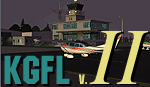
KGFL - Glens Falls, Floyd Bennett Memorial v2.2, located in the foothills of the Adirondack Mountains in upstate NY USA, this facility is owned by Warren County and run by RichAir. Although it has a 5000 ft main rwy, KGFL is a Non-controlled airfield catering to small engine a/c up to a few private jet daily traffic serving 'The Northcountry' New York. KGFL recently received several upgrades including 4 new GA hangars large enough to accommodate the needs of business jets.
All Objects fully designed and completely redone in GMAX using high resolution custom photo-real 32bit textures. Optional DXT textures included. Also includes new AFCAD file, more accurate airport grounds perimeter, satellite photo-real grounds, custom taxiways, taxi-signs and taxi lights, area roads, animated hangar doors, and near area landclass. No AI traffic tracks included with this release, but afcad designed to support several AI. Rwy12 objects required for a few static a/c and parking lot cars. v2.2 Includes mipmapped textures, reduced trees for better performance, and increased, more accurate taxiway light density. This v2.2 package is a full-install.
| Filename: | KGFL__Glens_Falls_Floyd_Bennett_Memorial_v22.zip |
| License: | Freeware, limited distribution |
| Added: | 5th February 2010, 16:52:44 |
| Downloads: | 2,348 |
| Author: | Ed 'Geneer' Cox |
| Size: | 74.81 MB |
| Category: Flight Simulator 2004 - AI Aircraft | |
| MAIW Offutt AFB |
|
Images related to this file:
File Description:

This freeware AI package, produced by Military AI Works, contains everything needed to activate Offutt Air Force Base in FS2004.
Offutt AFB is the home of the USAF Strategic Command (STRATCOM) and hosts the 55th Wing flying the famous "White Tops", a collection of intelligence,
surveillance and reconnaissance aircraft all derived from the Boeing C-135 airframe. The 55th Wing's mission is to provide dominant intelligence,
surveillance, reconnaissance; electronic attack; command and control; and precision awareness to national leadership and warfighters across the spectrum
of conflict any time, any place. This package contains seven different aircraft models along with custom made scenery for Offutt AFB,
customized flight plans for each aircraft, aircraft textures, a comprehensive airfield file, aircraft call signs and much more.
This package also includes the E-4B Nightwatch aircraft of the 1st Airborne Command and Control Squadron.
Credits: AFD's: MAIW Development Team & Giacomo Gramazio, Models: MAIW Development Team & Jan Martin, Flight Dynamics Design: Michael MacIntyre &
AI Aardvark, Effects: John Stinstrom & Michael MacIntyre, Repaints: Mark Walsh & Graham King, Voicepacks: Stewart Pearson, Flightplans: Giacomo Gramazio
& Desmond Burrell, Custom Scenery: MAIW Development Team, John Stinstrom & Paul Mitchell, Special thanks to Barry Taylor for extensive aircraft
research for this project.
| Filename: | MAIW_Offutt_AFB.zip |
| License: | Freeware |
| Added: | 22nd January 2014, 03:08:31 |
| Downloads: | 828 |
| Author: | MAIW Development Team |
| Size: | 24.42 MB |
| Category: Flight Simulator X - Scenery | |
| AR09 - Bella Vista Field - Arkansas, USA |
|
Images related to this file:
File Description:
This is my first attempt at creating an airport for FSX. This airfield is located in Gravette, Arkansas, and is currently owned by Hendren Aviation. I added a few assets, so that it would appeal more to the casual simmer. Such changes, for example, is adding a helicopter pad, when in real life there isn't one. The changes are very mild, and are pointed out on the included BMP. This airport should definitely appeal to anyone who is a bush pilot. The approach from the south is a bit challenging.
You must have the Acceleration addon. This is version 2.0, which supersedes version 1.0.Version 1.0 was given to only 2 people for testing purposes, and it shouldn't have found it's way onto the internet. Please contact me if you ever come across version 1.0.
Future updates will include accurate models of the buildings, accurate night lighting (it's a grass airstrip, and as of right now, the only lighting comes from street lights and buildings), and a few changes to the airport background.
I hope everyone enjoys this scenery as much as I enjoyed learning and creating it.
| Filename: | AR09__Bella_Vista_Field__Arkansas_USA.zip |
| License: | Freeware, limited distribution |
| Added: | 14th May 2015, 17:25:41 |
| Downloads: | 294 |
| Author: | JackRiordan |
| Size: | 8.25 MB |
| Category: Flight Simulator X - Scenery | |
| RAF Tarrant Rushton (1944) - Dorset, England |
|
File Description:
RAF Tarrant Rushton was a Royal Air Force station near the village of Tarrant Rushton east of Blandford Forum in Dorset, England from 1943 to 1947. It was used for glider operations during World War II and later revived for civilian operations. It is currently disused, though some buildings survive.
Horsa gliders from Tarrant Rushton left for France on the eve of D-Day, to begin Operation Tonga with an action that would later become known as Pegasus Bridge. Among the glider pilots was Jim Wallwork, on a Horsa nicknamed Lady Irene. The Tarrant Rushton gliders landed in occupied France shortly after midnight. Wallwork's aircraft was the first to touch down, but it landed heavily: the force of the impact catapulted both Wallwork and his co-pilot John Ainsworth through the front of the cockpit. Although stunned, this made them the first Allied troops to touch French soil on D-Day.
Other gliders were later flown from the airfield to Arnhem to take part in Operation Market Garden. During the closing stages of WWII, aircraft were used for SOE operations.
| Filename: | RAF_Tarrant_Rushton_1944__Dorset_England.zip |
| License: | Freeware |
| Added: | 22nd April 2016, 22:27:09 |
| Downloads: | 174 |
| Author: | Terry Boissel |
| Size: | 1.18 MB |
| Category: Flight Simulator 2004 - Scenery | |
| Airstrips of South-West France |
|
File Description:
Part two of my "Airstrips of Western Europe" project, these 90+ sceneries are mostly default basic airstrips from FS2004, enhanced with taxiways, parking spaces and aprons as appropriate, to facilitate the activation of lightweight GA AI traffic, primarily over the south-west of France. Hopefully these will allow a degree of continuity between my previous upload (Airstrips of North-West Europe) and the existing freeware releases for Spain and Portugal.
Again, there's no photo-realism here, just a selection of basic 'generic' buildings, more or less accurately sized and placed to reflect the airfield layout as seen on on-line satellite imagery and aerial photography. These buildings have minimal effect on frame-rates, so are ideal for this kind of job. The airfields are aligned as well as possible with the roads etc. in UT Europe and the Genesis Europe mesh, but should mostly be fine in a default installation or other configuration.
A good number of airfields in this area have been neatly implemented in the "Occitania_VFR" package, so I've not duplicated their work.
Also included are some "bonus" sceneries from further north that weren't included in my previous upload. Just copy them over as appropriate if required.
| Filename: | Airstrips_of_SouthWest_France.zip |
| License: | Freeware |
| Added: | 16th July 2024, 18:20:44 |
| Downloads: | 111 |
| Author: | Chris Eve |
| Size: | 274.73 KB |
| Category: Flight Simulator X - AI Flight Plans | |
| Mount Everest Expedition |
|
File Description:
Two flightplans for an expedition to Mount Everest (8852 m). The first flightplan takes you from Lukla (VNLK) airfield at 10000 ft to Mount Everest Climb North: Base Camp. A distance of about 40 km. The recommended inbuilt aircraft for this trip is the "Maule Orion on skis". Be aware that you must climb to about 15000 ft before entering the GPS-path. Also, you should try to land across the slope. Otherwise it could be difficult to stop the aircraft from skiing down the inclined ground!
The second flightplan takes you from Base Camp to Yak Camp* (at about 19000 ft MSL) sitting at a bend of the East Rongbuk Glacier. This is the first camp on the North Route. You should use a helicopter able to climb to about 20000 ft for this route. For example, the inbuilt Bell 206B JetRanger. Though, it will indeed be a challenge with this aircraft!
*= It is called the Yak Camp because it is the point at which the yak herders overnight their yaks on the route up to Advance Base Camp (ABC) at 21300 ft.
| Filename: | Mount_Everest_Expedition.zip |
| License: | Freeware |
| Added: | 1st May 2007, 23:20:13 |
| Downloads: | 1,671 |
| Author: | Ulf Norlinger |
| Size: | 127.04 KB |
| Category: Flight Simulator X - Scenery | |
| Teterboro KTEB version 2.0 |
|
File Description:
FSX Scenery--Teterboro Airport (KTEB), NJ. Teterboro Airport is located across the Hudson River in New Jersey, just 12 miles from midtown Manhattan. Teterboro Airport is considered a general aviation reliever airport. As a reliever airport, it does not offer scheduled airline service, nor does it permit operations of any aircraft in excess of 100,000 pounds on any airport surface. Teterboro Airport has five Fixed Base Operators (FBOs), Atlantic Aviation, Jet Aviation, First Aviation, Meridian, and Signature Aviation. Teterboro - KTEB version 2 includes the latest google earth photo texture that depics the completed construction work of the taxiways and aprons. Photo texture includes summer, fall, winter, and spring variance textures. Night textures also included,along with snow textures in the winter months. Vegetation autogen has been re-worked. All taxiways, taxisigns are present and depicted to real-life. Custom taxilights and runway ground markings included, the ground detail is exact. All stock FSX hangars have been replaced with custom hangars. Animated people and birds are found on the airfield. Numerous SAMM generated static business jets and some light general aviation aircraft are present. Enjoy!
| Filename: | Teterboro_KTEB_version_20.zip |
| License: | Freeware |
| Added: | 14th April 2011, 16:57:39 |
| Downloads: | 2,618 |
| Author: | Eric McCloud |
| Size: | 52.63 MB |
| Category: Flight Simulator 2004 - Scenery | |
| CYCS - Chesterfield Inlet - Nunavut, Canada Modified V1 |
|
Images related to this file:
File Description:
This version of Chesterfield Inlet corrects the VASI position on the runway, and also updates the taxiway edge lights to a newer and smaller version which is more realistically sized. This is a complete version and does not require you to have installed the old version. There is new AI, which is for Arviat, Whale Cove, and Chesterfield Inlet; this enlarges on and replaces the version posted with Whale Cove so use this one. The First Air and Calm Air flights also visit Rankin Inlet (made by Sid) and the GA flights originate in Rankin Inlet. There is a revised Rankin Inlet bgl so that the planes are allowed to use the gates. Chesterfield Inlet is a small village on the west coast of Hudson Bay, with a population of 340 or so. It is the oldest community in Nunavut and was established around a Hudson Bay Company post in 1911. It is 55 miles north of Rankin Inlet (Sid and Pete's post). The airfield is close to the village and has a gravel runway 3,600 feet long aligned 124T/304T (true, not magnetic).
| Filename: | CYCS__Chesterfield_Inlet__Nunavut_Canada_Modified_.zip |
| License: | Freeware, limited distribution |
| Added: | 23rd August 2014, 11:22:36 |
| Downloads: | 198 |
| Author: | Roger Wensley |
| Size: | 3.3 MB |
| Category: Flight Simulator 2004 - Scenery | |
| Wrigley CYWY - Northwest Territories, Canada |
|
Images related to this file:
File Description:
Wrigley is the next in a series of airfields that follow (approximately) in a southward direction that early access route to the Canadian northern shore, the Mackenzie River. At the far northern end there is Tuktoyaktuk, then Inuvik, Fort McPherson, Fort Good Hope, and Deline, all posted. Wrigley is at 489 feet asl and on the east bank of the the Mackenzie, around 135 miles due south of Deline. The town of Wrigley has a population of only 125 or so folks, and was relocated to its current position in 1965 from Fort Wrigley to be near the WW2 era airfield; I have no idea where Fort Wrigley is, or was. The airport is just over a mile south of the town, and has 3,500 feet of gravel runway. North Wright Air have scheduled flights to here and other airfields up and down the Mackenzie (including Deline, Fort Simpson, and Fort Good Hope etc) which is reflected in the revised AI. There is again a mandatory radio frequency but I have set the "tower" as unmanned so you will announce intentions and join downwind. There is no fuel available.
| Filename: | Wrigley_CYWY__Northwest_Territories_Canada.zip |
| License: | Freeware, limited distribution |
| Added: | 5th July 2014, 21:01:37 |
| Downloads: | 211 |
| Author: | Roger Wensley |
| Size: | 3.81 MB |
| Category: Flight Simulator 2004 - Scenery | |
| Deline CYWJ - Northwest Territories, Canada |
|
Images related to this file:
File Description:
This is the third in a series of airfields that follow in a southward direction that early access route to the Canadian northern shore, the Mackenzie River. Deline is south of Tuktuk, Inuvik, Fort McPherson, and Fort Good Hope, all already posted. Deline is at 704 feet asl and around 50 miles east of the the Mackenzie, where the Great Bear River flows out of the western end of Great Bear Lake on its way to the Mackenzie. This lake is huge. The town of Deline has a population of around 500, and the first trading post (of the North West Company) was established there as early as 1799. The Hudson Bay Company opened an outpost in 1825 to support the Franklin Arctic Exploration expedition, and it was then called Fort Franklin. The name was changed to Deline in 1993. The airport is just over a mile north of the town, and has almost 4,000 feet of gravel runway. There is no fuel available. The original airfield is still visible just to the north of the town, from before it was rebuilt on higher ground (better drainage) and away from the houses. AI will follow with later posts.
| Filename: | Deline_CYWJ__Northwest_Territories_Canada.zip |
| License: | Freeware, limited distribution |
| Added: | 5th July 2014, 14:47:36 |
| Downloads: | 240 |
| Author: | Roger Wensley |
| Size: | 2.54 MB |
© 2001-2026 AVSIM Online
All Rights Reserved
Privacy Policy |