
Where Flight Simulation Enthusiasts Gather from Around the World!
AVSIM Library - Search Results

| Category: Flight Simulator 2004 - Scenery | |
| Kimmirut CYLC on Baffin Island in Nunavut, Canada |

|
Images related to this file:
File Description:
Kimmirut is a village of some 400 folks at the southern end of the southwest-facing coast of Baffin Island, 75 miles southwest of Iqaluit. It is on the northern side of the Hudson Strait between Baffin Island and Quebec, opposite Kangiqsujuaq on the Quebec shore. The airfield is served by two flights per week, one on Monday and another on Friday, only half fueled to be able to use the 1,899' of gravel 75' wide runway. The terminal building is small and there is a garage building for airport maintenance vehicles (snow clearing). There are some nearby buildings that I have included. The village is "represented" (not "modeled") with approximately the right shape and road layout. Take enough fuel so that you can leave again, as fuel is no longer for sale here. The Cape Dyer bgls are to make a small correction, it is explained in the text. I will not be posting new sceneries in the future and this is the last one for Avsim; it completes Baffin Island.
| Filename: | Kimmirut_CYLC_on_Baffin_Island_in_Nunavut_Canada.zip |
| License: | Freeware, limited distribution |
| Added: | 25th July 2011, 17:36:57 |
| Downloads: | 534 |
| Author: | Roger Wensley |
| Size: | 2.53 MB |
| Category: Flight Simulator 2004 - Scenery | |
| Alaska South Slope 4; Selawik PASK |
|
Images related to this file:
File Description:
There are four main northwestern Alaska towns which are serviced by Alaska Airlines, and from which local flights spread out. The northernmost is Barrow. Southwest of Barrow is Kotzebue, then Nome, and the furthest south is Bethel. This series is for the flights from and around Kotzebue, mostly on the South Slope of the Brooks Range of mountains. There will be further additions. Selawik is a village (population now around 760) around 75 miles east of Kotzebue on three of the delta islands of the Selawik River where it flows into Selawik Lake. The delta forms part of the Selawik National Wildlife Refuge for migratory birds. The airfield is just next to the village, with two runways, 3,450 feet of lit gravel aligned 03-21 and 3,100 feet of gravel aligned 09-27. There are scheduled flights by Era (now renamed Ravn) and by Bering Air, both of them originating in Kotzebue and routing east to Noorvik, Kiana, Selawik, etc, and then back again. The AI includes these flights along with Everts Air and GA.
| Filename: | Alaska_South_Slope_4_Selawik_PASK.zip |
| License: | Freeware, limited distribution |
| Added: | 9th October 2016, 04:17:52 |
| Downloads: | 212 |
| Author: | Roger Wensley |
| Size: | 4.34 MB |
| Category: Flight Simulator X - Scenery | |
| Essweiler Gliderfield, Germany Ver. 1.0 |
|
Images related to this file:
File Description:
Essweiler is actually a classic glider field, but also engine aircrafts up to 2t are approved.
The field is situated in the region Rheinland-Pfalz/Germany at a hillside eastly of the village Essweiler, approximately 7,5 nautical miles north of the well known US-Airbase Ramstein.
The environment of the airfield is adapted by land classes. Surrounding villages and major roads are initially implemented.
As well the field is covered by a photo background, which includes four different images , each for one of the four seasons: spring, summer, autumn and winter. The buildings in this scenery should match quite good the originals. But also a lot of objects from three very popular freeware libraries are used.
If these libraries are not installed, many objects are not visible!
The following libraries are used:
1. FS-Piloten_Objektlibrary:
http://www.fs-piloten.de/thread.php?threadid=1063
2. FSX_FlightPortLib
http://www.flightport.de/libraries/flightport-library/
3: 3d People Library
http://library.avsim.net/download.php?DLID=192454
| Filename: | Essweiler_Gliderfield_Germany_Ver_10.zip |
| License: | Freeware |
| Added: | 29th November 2016, 19:15:50 |
| Downloads: | 605 |
| Author: | Wolfgang Allers |
| Size: | 168.18 MB |
| Category: Flight Simulator X - Scenery | |
| EGXJ - RAF Cottesmore - Rutland, England |
|
File Description:
RAF Cottesmore (ICAO EGXJ) is a former Royal Air Force station in Rutland, England, situated between Cottesmore and Market Overton.
The Stationed opened on 11 March 1938 and was used mainly for training, and the first squadrons were equipped with Vickers Wellesley aircraft, but soon converted to Fairey Battles. Later RAF Bomber Command took over the airfield, again as a training station, flying Handley Page Hampdens. These units remained in residence until a few days before the outbreak of war in 1939 when they were sent to RAF Cranfield to serve as a pool providing replacements for combat losses. Their place at Cottesmore was taken by Nos. 106 and 185 Squadrons, moving in from RAF Thornaby with Hampdens. However, with the outbreak of war, the aircraft and crews were sent to locations in the north and west, as enemy air attacks were expected over the southern half of England. As these never materialised, the Hampdens returned in the spring of 1940 and No. 185 Squadron became the Hampden operational training unit, No. 14 Operational Training Unit RAF.
RAF Cottesmore's Hampdens' first trespass into hostile airspace was a leaflet dropping operation over northern France. In October 1940, 106 Squadron moved to RAF Finningley while No. 14 OTU remained training crews for Bomber Command, its Hampdens and HP.53 Herefords being replaced by Vickers Wellingtons in 1942. Training continued for three years and three months until August 1943 when No. 14 OTU moved to RAF Market Harborough.
In early December 2009, it was announced the station would close due to funding cut-backs, in part to help pay for additional helicopters for British operations in Afghanistan.
In 2010, No. 4 Squadron RAF disbanded, with No. 20 Squadron RAF re-badging as No 4 (Reserve) Squadron.
The station became a satellite to RAF Wittering on 31 March 2011 with a civic parade and flypast to mark the disbandment of No 1 Sqn RAF, 800 NAS, 801 NAS and JFH.
In July 2011 Defence Secretary Liam Fox announced plans for it to be the airfield for one of five of the Army's Multi-Role Brigades. In April 2012 it was renamed Kendrew Barracks after Major General Sir Douglas Kendrew.
Source: Wikipedia
| Filename: | EGXJ__RAF_Cottesmore__Rutland_England.zip |
| License: | Freeware |
| Added: | 19th March 2016, 12:15:07 |
| Downloads: | 344 |
| Author: | Terry Boissel |
| Size: | 1.66 MB |
| Category: Flight Simulator 2004 - Scenery | |
| CYCE - James T. Field Memorial at Centralia, Ontario, Canada V1 updated |
|
Images related to this file:
File Description:
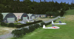
This is an updated version of the original post, revising and adding to AI, parking, rear fences, paths from apron to hangar doors, etc. The Lockheed Constellation was downloaded from the web site California Classics, and with the knowledge and permission of Tom Gibson the modified plane is included here complete with its Air Alaska textures and a modified .cfg file so that it will imitate a lightly loaded plane and squeeze the landing run to suit the runway length of 10-28. The airfield is in southern Ontario, 55 miles west of Kitchener and 25 miles northwest of London, close to the shore of Lake Huron. The airfield is ex-military and was previously listed as Huron Airpark before being officially named the James T. Field Memorial; for me it will always be Huron Airpark. The field is owned by Goderich Aircraft Inc, a company that fits out aircraft with new interiors including instrumentation, seating, and paint schemes. Their main customers are business jet owners, which is why the AI here is oriented towards Lear etc. There are now two runways in use, the third being closed and marked as such (though still listed in the AI for you to select one to land on). The main runway is 10-28 and just over 5,000 feet. The second runway is 16-34 and 4,400 feet, with only identification numbers and centreline markings. There appear to be no apron lights, taxiway lights or runway signage currently installed. There is a small club hangar (and club room) adjacent to the main apron at the southern end, with GA parking, and there are two large hangars (one new) used by Goderich at the northern end. The remainder of the original large hangars are now in use as light industrial units unrelated to aviation, the most obvious of which is a garbage collection company with numerous parked garbage trucks. One of the hangars adjacent to the apron does incorporate what appears to be a new set of hangar doors (the red one) but it is unclear if this is actually in use for a plane. The control tower is no longer in use, and there is only limited snow clearance in the winter by Goderich; presumably they only clear it when they need to use it themselves.
| Filename: | CYCE__James_T_Field_Memorial_at_Centralia_Ontario_.zip |
| License: | Freeware, limited distribution |
| Added: | 24th November 2016, 22:20:37 |
| Downloads: | 324 |
| Author: | Roger Wensley |
| Size: | 13.92 MB |
| Category: X-Plane - Scenery | |
| US MI KBTL - WK Kellogg Airport Battle Creek v2.0.0 |
|
Images related to this file:
File Description:
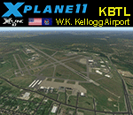
This is an X-Plane 11 and X-Plane 10 scenery package for the W.K. Kellogg Airport (IATA: BTL, ICAO: KBTL, FAA LID: BTL), which is a city owned, public use, joint civil-military airport located three nautical miles (6 km) west of the central business district of Battle Creek, a city in Calhoun County, Michigan, United States. v2.0.0 completely replaces the KBTL v1.0.2, with a brand new scenery, including orthophoto and city building for downtown Battle Creek. For better performance, only the default X-Plane libraries, by Laminar Research, are needed. No third party libraries are used. It includes corrected aprons, ramps, gates, taxiways, lighting system, city downtown buildings, ortho-photoscenery for the airfield area, and (XP11 only) airport ground services (like push back). This scenery was tested and is operational (as of March 20, 2017) in "X-Plane 11 Public Beta #15 64 bit", Windows 10 Home. It was also tested and is also operational (as of March 20, 2017) in "X-Plane 10.51 64 bit", Windows 10 Home. Only the default X-Plane libraries, by Laminar Research, are needed. No third party libraries are used.
| Filename: | US_MI_KBTL__WK_Kellogg_Airport_Battle_Creek_v200.zip |
| License: | Freeware |
| Added: | 22nd March 2017, 00:06:30 |
| Downloads: | 69 |
| Author: | Rui Mesquita |
| Size: | 22.38 MB |
| Category: Flight Simulator X - Scenery | |
| RAF Barkston Heath - 1944 |
|
File Description:
At the time of its construction, RAF Barkston Heath in common with a number of other airfields in the Grantham area had been planned for the RAF's No. 7 Group. In late 1943, Barkston Heath was made available to the United States Army Air Forces Ninth Air Force and designated as USAAF station 483. It was earmarked for basing troop carrier units scheduled to be transferred from Sicily to participate in the forthcoming cross-Channel invasion, Operation "Overlord"
American 61 TCG aircraft based at Barkston Heath carried British paratroops on the ill-fated operation Market Garden.
The USAAF returned control of the airfield to the Air Ministry in June 1945 when the war in Europe ended. Barkston Heath was used by No 256 Maintenance Unit and No 2 RAF Regiment. Beginning in May 1948.,
RAF Barkston Heath has the Naval and Army Elements of No. 3 Flying Training School (3 FTS) which, for a period between approximately 1995-2010 operated the Slingsby T67M260 Firefly two-seat trainer. The school now operates the Grob Tutor T1. A secondary role of RAF Barkston Heath is as a Relief Landing Ground for the flying training activities at RAF Cranwell.
Source: Wikipedia
| Filename: | RAF_Barkston_Heath__1944.zip |
| License: | Freeware |
| Added: | 10th March 2017, 07:13:15 |
| Downloads: | 150 |
| Author: | Terry Boissel |
| Size: | 1.05 MB |
| Category: X-Plane - Scenery | |
| BR SP SBST - Santos Airport v1.0.0 |
|
Images related to this file:
File Description:
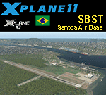
This is an X-Plane 11 and X-Plane 10 scenery package for Nero Moura Airport, also know as Santos Air Base, or BAST, (IATA: SSZ, ICAO: SBST), which is an airport and base of the Brazilian Air Force located in the city of Guarujá, state of São Paulo, in Brazil. The operation of civil aircraft for refueling may be possible upon authorization of the commander of Santos Air Base.
It includes corrected aprons, ramps, gates, taxiways, lighting system, city buildings, the Santos Harbour and Port area, ortho-photoscenery for the airfield area, and (XP11 only) airport ground services (like push back).
On June 22, 2015, the airport received a concession for a commercial airport in the city, named Guarujá Metropolitan Civil Aerodrome, to serve the Baixada Santista metropolitan area. The new structure will divide space with BAST and will have the widening of the airstrip.
This scenery was tested and is operational (as of January 24, 2018) in "X-Plane 11.11 64 bit", Windows 10 Home. It was also tested and is also operational (as of January 24, 2018) in "X-Plane 10.51 64 bit", Windows 10 Home.
| Filename: | BR_SP_SBST__Santos_Airport_v100.zip |
| License: | Freeware |
| Added: | 2nd February 2018, 00:11:48 |
| Downloads: | 72 |
| Author: | Rui Mesquita |
| Size: | 146.08 MB |
| Category: Flight Simulator 2004 - Aircraft Repaints, Textures and Modifications | |
| Bonanza Airlines Douglas DC-3 |
|
File Description:
FS2004. Texture sets only, requiring the base model of the GMAX MAAM-SIM R4D/DC-3 available from www.maam.org. Based on original textures by Jan Visser. Bonanza Air Services (BAS) was formed in early in 1945 by Edmund Converse, a former lieutenant commander in the U.S. Navy; Charlie Keene, once an operator of a small charter operation in Santa Paula, California; and June Simon, daughter of "Pop" Simon the former secretary-director of the Las Vegas Chamber of Commerce. BAS located its home base at the Sky Haven Airfield, now known as the North Las Vegas Air Terminal, and began operating with just one single-engine, four-seat Cessna. The company offered charter flights to several small Nevada towns but needed a place to promote its product. The trio struck a deal with the El Rancho Vegas Hotel and Casino to set up a ticket counter in the lobby. Bonanza Air Lines was the aviation pioneer in the western United States and proved to be a vital link in the air transportation industry. In it's 23 years of operation BAL growth continued up until the time of the merger. Bonanza will be remembered as a successful airline.
| Filename: | Bonanza_Airlines_Douglas_DC3.zip |
| License: | Freeware |
| Added: | 22nd September 2005, 18:07:43 |
| Downloads: | 2,865 |
| Author: | Tim Trivett |
| Size: | 5.15 MB |
| Category: Flight Simulator X - Scenery | |
| RAF Scorton |
|
File Description:
RAF Scorton was opened in October 1939 as part of 13 Group Fighter Command and a satellite station of RAF Catterick. It was located near the village of Scorton in North Yorkshire. It was used by the Royal Air Force, the Royal Canadian Air Force, and the United States Army Air Forces Ninth Air Force during the war.
The location was chosen for its flat terrain and its situation close to the now disbanded Eryholme-Richmond branch line that had a sub branch line to Catterick Garrison and RAF Catterick.
The famous No. 56 Squadron RAF flew Spitfires from Scorton during the Second World War. Also the USAAF 422d and 425th Night Fighter Squadrons were stationed at Scorton flying the Northrup P-61 "Black Widow" fighter.
The Aerodrome closed in 1945 and most of the concreted areas have been extensively quarried away for sand and gravel extraction. Most of what was the airfield is now under a lake or a quarry. There are a few military pre-fab buildings remaining in the area – they were dismantled after the war and moved to local farms to be used as agricultural buildings.
Source:Wikipedia
| Filename: | RAF_Scorton.zip |
| License: | Freeware |
| Added: | 26th February 2017, 07:30:57 |
| Downloads: | 86 |
| Author: | Terry Boissel |
| Size: | 2.52 MB |
© 2001-2026 AVSIM Online
All Rights Reserved
Privacy Policy |