
Where Flight Simulation Enthusiasts Gather from Around the World!
AVSIM Library - Search Results

| Category: Flight Simulator 2004 - Scenery | |
| Warnervale, NSW, Australia |

|
File Description:
This version is a major update of this fine little airport
with the permission of Greg Archer, the original author.
Upgrades include the Terminal building, Booking office,
some hangars, lights and trees all featuring photo real textures.
An AFCAD file and AI traffic are now included.
Warnervale NSW, is a small airfield not included in FS2002 or 2004.
It is however a busy little field run by the Central Coast Aero Club
and incorporates the Drop Zone Skydiving Centre, as well as
Joy Flights over the Beautiful Central Coast of NSW.
The field is very close to Aeropelican Airport home of
Aeropelican Airways which has regular services to
Sydney Kingsford Smith International using Twin Otters.
in fact you can see Aeropelican Airstrip 8NM to the
north once you take off from Warnervale.
You can download Aeropelican from this site (aero2004.zip).
Both airfields complement each other, just follow the sail boats north.
Textures required. Airport 2.6, VOD, Nova and Nova Gold.
| Filename: | Warnervale_NSW_Australia.zip |
| License: | Freeware |
| Added: | 4th June 2004, 14:04:15 |
| Downloads: | 1,769 |
| Author: | Clive Marriott |
| Size: | 1.9 MB |
| Category: Flight Simulator 2004 - Scenery | |
| CYEK - Arviat - Nunavut, Canada v 1.1 |
|
Images related to this file:
File Description:
This version of Arviat corrects the VASI position on the runway, and also updates the taxiway edge lights to a newer and smaller version which is more realistically sized. This is a complete version and does not require you to have installed the old version. You can just replace the existing .bgl's and the existing textures in the scenery and texture folders if you already have this scenery. Arviat is a small town on the west coast of Hudson Bay in Nunavut, around 90 miles south of Whale Cove, 130 miles south of Rankin Inlet, and 160 miles north of Churchill. The airfield is just south of the town, and the 4,000 feet of gravel runway is aligned 149T/329T, as these are true bearings and not magnetic, as Arviat is just inside the Northern Domestic Airspace zone. There is 100LL fuel available in drums, with 2 hours prior notice. The visiting AI airline is Calm Air, plus a cargo delivery by Buffalo Air.
| Filename: | CYEK__Arviat__Nunavut_Canada_v_11.zip |
| License: | Freeware, limited distribution |
| Added: | 23rd August 2014, 11:20:05 |
| Downloads: | 226 |
| Author: | Roger Wensley |
| Size: | 2.33 MB |
| Category: Flight Simulator 2004 - Scenery | |
| CYZS - Coral Harbour - Nunavut, Canada Modified V1 |
|
Images related to this file:
File Description:
This modified version of Coral Harbour corrects the PAPI postion on the runway, installs new taxiway lights and windsocks, and modifies the AI. This is a complete version and does not require you to have installed the original. Coral Harbour is on Southampton Island, which partly blocks the northern end of Hudson Bay and is around the size of Switzerland. The village has a population of just under 800 people and is some 200 miles from Cape Dorset, Ivujivik, and Repulse Bay, and 230 miles from Chesterfield Inlet to the southwest. The airfield is inland from the village and the 5,000 feet of gravel runway is aligned 155T/335T where T stands for "true" as opposed to magnetic in the Northern Domestic Airspace. JETA-1 fuel is officially available, and in practice so is 100LL, though the latter will be in drums. The visiting AI airlines are First Air and Calm Air, and there is a GA plane too that is stock FS9.
| Filename: | CYZS__Coral_Harbour__Nunavut_Canada_Modified_V1.zip |
| License: | Freeware, limited distribution |
| Added: | 23rd August 2014, 11:25:23 |
| Downloads: | 222 |
| Author: | Roger Wensley |
| Size: | 12.92 MB |
| Category: Flight Simulator 2004 - Scenery | |
| Waskaganish CYKQ in James Bay, Quebec, Canada |
|
Images related to this file:
File Description:
Waskagansh is a village with 2,500 or so inhabitants at N51 28 W78 45 on the southeast shore of James Bay. It was founded in 1668 as Fort Charles (later it became Fort Rupert) and was the first Hudson's Bay Company trading post in the James Bay area. The village's current name means Little House in the Cree language. The village does not feature in FS9 but is included in this scenery with approximately the right shape; just think of it as a hand-made auto-generated village.
I also had to add the roads (the file called "waskROADS"), delete the stock airfield background ("WaskDELETE"), and add a new background ("WaskGRASS") plus of course there is the usual scenery file and the AFCAD and AI. There is also a note in here on what to do about a possible texture problem for the village that I have discussed with two downloaders and solved. I hope.
| Filename: | Waskaganish_CYKQ_in_James_Bay_Quebec_Canada.zip |
| License: | Freeware, limited distribution |
| Added: | 21st October 2010, 23:32:16 |
| Downloads: | 541 |
| Author: | Roger Wensley |
| Size: | 1.38 MB |
| Category: Flight Simulator X - Scenery | |
| KGFL - Floyd Bennett Memorial - Glens Falls, New York v3.0 |
|
Images related to this file:
File Description:
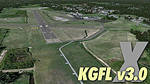
KGFL - Glens Falls, Floyd Bennett Memorial v3.0, located in the foothills of the Adirondack Mountains in upstate NY USA, this facility is owned by Warren County and run by RichAir. Although it has a 5000 ft main rwy, KGFL is a Non-controlled airfield catering to small engine a/c up to a few private jet daily traffic serving 'The Northcountry' New York. KGFL recently received several upgrades including 4 new GA hangars large enough to accommodate the needs of business jets. All Objects fully designed and completely redone in GMAX using high resolution custom photo-real textures. Complete rebuild from the ground up for FSX since v2.2 for Fs9. Also includes new ADE file, more accurate airport grounds perimeter, satellite photo-real grounds, custom taxiways, 3D taxi-signs and taxi lights, area roads, animated hangar doors, and near area landclass. No AI traffic tracks included with this release, but ADE designed to support several AI. FSX Acceleration required.
| Filename: | KGFL__Floyd_Bennett_Memorial__Glens_Falls_New_York.zip |
| License: | Freeware, limited distribution |
| Added: | 5th February 2013, 06:14:14 |
| Downloads: | 2,294 |
| Author: | EdGeneer Cox |
| Size: | 143.72 MB |
| Category: Flight Simulator 2004 - Scenery | |
| Inukjuak CYPH - Northern Quebec, Canada |
|
Images related to this file:
File Description:
Inukjuak is a fairly large village on the east coast of Hudson Bay, in Quebec, around 115 miles south of Puvirnituq. The usual Hudson Bay Company post was established there in 1920, and with the opening of a school in 1951 the population grew as the nomadic way of life faded away; the population is now around 1350. Some of the population was forcibly relocated to Resolute and Grise Fiord in 1953 as "human flagpoles", a shameful act by the Canadian government that is hard to believe could ever happen. The airfield is a mile inland from the village and the 3,520 feet of gravel runway is aligned 07/25, and these are magnetic bearings as Inukjuak is not in the Northern Domestic Airspace zone. Both JETA-1 and 100LL fuel is available, though there may be only a limited quantity of 100LL, and probably in drums. The visiting AI airline is Air Inuit.
| Filename: | Inukjuak_CYPH__Northern_Quebec_Canada.zip |
| License: | Freeware, limited distribution |
| Added: | 12th December 2011, 14:44:32 |
| Downloads: | 539 |
| Author: | Roger Wensley |
| Size: | 1.81 MB |
| Category: Flight Simulator 2004 - Scenery | |
| Niederrhein - Laarbruch 2009 v0.8 |
|
Images related to this file:
File Description:
Along the Dutch border, four airbases were built. All four of them had about the same shape and dimensions. All four of them were RAF bases, operated by RAF Germany, serving in the cold war. Slowly, one by one, they either closed or were converted for other uses. Geilenkirchen became a NATO base with AWACS aircraft operating, Wildenrath closed in 1990 to be converted into a Siemens train testing center. Brueggen closed in 2002 and I think it is now being used as army base. Laarbruch closed in 1999, to reopen as a civil airfield in May 2003.
------------
This scenery is a kind of beta version, I kindly ask you to read all about that in the readme word document. This scenery features all new 3D objects, including photorealistic elements. In my opinion this scenery captures the EDLV - ETUL atmosphere very well. The airport is located near Weeze in Germany.
Please forget about my previous EDLV versions - this one is way better.
| Filename: | Niederrhein__Laarbruch_2009_v08.zip |
| License: | Freeware |
| Added: | 3rd March 2010, 03:36:30 |
| Downloads: | 2,408 |
| Author: | Nils Lips |
| Size: | 5.55 MB |
| Category: Flight Simulator 2004 - Scenery | |
| Airstrips east of the Alps |
|
File Description:
A collection of over 70 small airfields in Hungary, Slovakia, Slovenia and Croatia, many of which aren't featured in FS2004, each enhanced with taxiways, parking spaces, buildings etc. and aprons as appropriate, to fill in a few gaps to the north-east of Italy and to allow the generation of lightweight GA AI traffic in this area and into the adjacent countries.Again, there's no photo-realism here, just a selection of basic 'generic' buildings, more or less accurately sized and placed to reflect the airfield layout as seen on on-line satellite imagery and aerial photography. These buildings have minimal effect on frame-rates, so are ideal for this kind of job. The airfields are aligned as well as possible with the roads etc. in UT Europe, where applicable, and the Genesis Europe mesh, but should mostly be fine in a default installation or other configuration.
| Filename: | Airstrips_east_of_the_Alps.zip |
| License: | Freeware |
| Added: | 12th September 2025, 13:29:14 |
| Downloads: | 56 |
| Author: | Chris Eve |
| Size: | 785.49 KB |
| Category: Flight Simulator X - Aircraft Repaints, Textures and Modifications | |
| P-40N Warhawk "Little Jeanne" (F-AZKU) |
|
Images related to this file:
File Description:
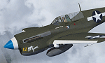
A repaint only for the payware Flight Replicas P-40N Warhawk. This repaint depicts the restored P-40N 42-105915, "Little Jeanne", registered F-AZKU. This aircraft operated in the Pacific during WWII, with the 7th FS, 49th FG, flown by Lt. Robert Warren. In the 1970's the aircraft was recovered along with several other WWII combat vet aircraft from Tadji Airfield in New Guinea. Displayed for many years in Australia, the aircraft eventually found its way to Murray Griffith and a restoration to airworthy at Precision Aerospace. Finished in its original wartime markings, the aircraft flew again in 2002, registered VH-KTI. The aircraft was operated in Australia until being sold in 2007 to the French Amicale Jean-Baptiste Salis association, based at La Ferte Alais. The aircraft is a regular air show participant at various European air shows, including Duxford's annual "Flying Legends" show and the annual "Meeting Aerien la Ferte Alais".
| Filename: | P40N_Warhawk_Little_Jeanne_FAZKU.zip |
| License: | Freeware |
| Added: | 28th July 2013, 18:32:37 |
| Downloads: | 141 |
| Author: | John Terrell |
| Size: | 8.46 MB |
| Category: Flight Simulator 2004 - AFCAD Files | |
| EBOS Oostende/Brugge International Airport, Ostend, Belgium (includes modified twy signs!) |
|
File Description:
These files are for the FS9 default. The "AF2_EBOS_DF.BGL" file is based on the Microsoft Virtual Earth aerial photography (via "Flash Earth"). It is an extensive modification of a file by Jean-Philippe Delwiche (merci Monsieur!). The "EBOS_twy_signs.BGL" file corrects the taxiway sign positions and content, and the exclude files prevent any default scenery from obstructing the airfield. Because I like the interesting variation and "East meets West" feel of the Oostende traffic, I like to pass through once in a while. Therefore, it is important to me that the layout is at least proportionally genuine, and a better reflection of reality than the default.
My thanks to Jean-Philippe Delwiche (aka JeePee) for his kind permission for my use of his work.
Also, thanks to Jan Martin for his guide to taxiway sign editing, which I hope I have used to good effect.
This release complements my Air Charter Express and MK Airlines flightplans well.
| Filename: | EBOS_OostendeBrugge_International_Airport_Ostend_B.zip |
| License: | Freeware |
| Added: | 11th May 2009, 01:06:04 |
| Downloads: | 725 |
| Author: | Dan Foster |
| Size: | 1.5 MB |
© 2001-2026 AVSIM Online
All Rights Reserved
Privacy Policy |