
Where Flight Simulation Enthusiasts Gather from Around the World!
AVSIM Library - Search Results

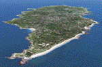
| Category: Flight Simulator X - Scenery | |
| Bembridge X-HD |

|
Images related to this file:
File Description:

Bembridge is one of only two airports on the Isle of Wight, it is small but a very picturesque area. This scenery is provided with photo real surround to give you a smoother transition from HD to default scenery.
The airport offers pleasure flights for a small fee and of course a flight school operates at the airport.
This scenery is perfect for anyone with a love of GA flying, the surrounding photo scenery allows for VFR operations and the airport is accurately placed in the virtual world.Feature include:
High definition ground image.
High definition ground detailing.
Filler objects from "SFC Airfield Objects".
Precision placed trees and vehicles.
Fuel trucks hidden inside closed hangars.
Real water in the pond.
Hold short guards.
Many static vehicles and details.
Accurate BN Aviation hangars.
Very low frame impact.
| Filename: | Bembridge_XHD.zip |
| License: | Freeware, limited distribution |
| Added: | 8th January 2017, 23:55:14 |
| Downloads: | 1,565 |
| Author: | Mark Piccolo - Soarfly Concepts |
| Size: | 30.34 MB |
| Category: Flight Simulator X - AFCAD Files | |
| CYQQ - CFB Comox, British Columbia, Canada. |
|
File Description:
Canadian Forces Base Comox (IATA: YQQ, ICAO: CYQQ), commonly referred to as CFB Comox, is a Canadian Forces Base located 2.5 NM (4.6 km; 2.9 mi) north northeast of Comox, British Columbia. It is primarily operated as an air force base by Canadian Forces Air Command and is one of two bases in the country using the CP-140 Aurora anti-submarine/maritime patrol and surveillance aircraft. Its primary lodger unit is 19 Wing.
CFB Comox's airfield is also used by civilian aircraft, with civilian operations at the base referring to the facility as Comox Airport. The airport is classified as an airport of entry by NAV CANADA and is staffed by the Canada Border Services Agency. CBSA officers at this airport currently can handle general aviation aircraft only, with no more than 15 passengers.
| Filename: | CYQQ__CFB_Comox_British_Columbia_Canada.zip |
| License: | Freeware |
| Added: | 5th November 2009, 02:16:02 |
| Downloads: | 602 |
| Author: | Robert Catherall |
| Size: | 1.22 MB |
| Category: Flight Simulator 2004 - Scenery | |
| Coral Harbour CYZS in Nunavut, Canada |
|
Images related to this file:
File Description:
Coral Harbour is on Southampton Island, which partly blocks the northern end of Hudson Bay and is around the size of Switzerland. The village has a population of just under 800 people and is some 200 miles from Cape Dorset, Ivujivik, and Repulse Bay, and 230 miles from Chesterfield Inlet to the southwest. Cape Dorset and Ivujivik have already been posted and Chesterfield Inlet will be posted later this month. The airfield is inland from the village and the 5,000 feet of gravel runway is aligned 155T/335T where T stands for "true" as opposed to magnetic in the Northern Domestic Airspace. JETA-1 fuel is officially available, and in practice so is 100LL, though the latter will be in drums. The visiting AI airlines are First Air and Calm Air.
| Filename: | Coral_Harbour_CYZS_in_Nunavut_Canada.zip |
| License: | Freeware, limited distribution |
| Added: | 29th November 2011, 00:43:08 |
| Downloads: | 369 |
| Author: | Roger Wensley |
| Size: | 3.83 MB |
| Category: Flight Simulator 2004 - Scenery | |
| Altitude adjustment for Dawson City CYDA |
|
Images related to this file:
File Description:
I discovered that the Northern Canada Terrain Mesh that I installed a while back was dumping part of my Dawson City Airport CYDA into a deep hole. I tried making a flatten to reduce the height of the terrain mesh land but that did not look at all realistic. So, the solution is to raise CYDA to 1,457 feet above sea level instead of the correct (correct according to the Nav Canada Supplement) level of 1,215 feet so that it melts into the surrounding terrain. There are still some rocky faces but at least they are not in the airfield. Do you need it? Not if your version looks ok. If it doesn't look ok then try this, but save your current version so you can go back to it if you need to.
| Filename: | Altitude_adjustment_for_Dawson_City_CYDA.zip |
| License: | Freeware, limited distribution |
| Added: | 23rd July 2019, 17:24:26 |
| Downloads: | 103 |
| Author: | Roger Wensley |
| Size: | 855.58 KB |
| Category: Flight Simulator X - Scenery | |
| Yeu island - LFEY |
|
Images related to this file:
File Description:
The island of Yeu (LFEY) is located in the west of France, in the south-west of Nantes. Its main runway is located on the wild coast, near the great lighthouse.
It is made up of :
- A new mesh based ASTER compiled in LOD11 and a very local mesh for the airport, compiled in LOD13 to get a good compatibility with the specific payware meshes.
- Photorealistic texture at 0.5 m/pixel based on aerial photography.
- The airfield and runway. The runway is flat, allowing to preserve the AI traffic. The grass strip is modeled with its relief. There is therefore no AI traffic on the grass strip.
- The port of Port-Joinville and several notable buildings made with Gmax (churches, chapel, castle, fort, ruins, beacons, etc)
- Generic or custom objects created with Gmax (boats, buildings).
| Filename: | Yeu_island__LFEY.zip |
| License: | Freeware |
| Added: | 29th December 2012, 04:03:47 |
| Downloads: | 1,717 |
| Author: | marc guitteny |
| Size: | 217.78 MB |
| Category: Prepar3D V1-4 - Aircraft Repaints, Textures and Modifications | |
| Japan Universal System Transport 1993 AI Package |
|
File Description:
Japan Universal System Transport (JUST) was a Japanese cargo airline that operated a single 747-200F with a whale on the tail named "Yu-Chan" starting in 1991. The airline hauled freight between Tokyo-Haneda(HND) and New Chitose(CTS) and Nagoya Airfield(NKM). It found some success on this route, and JAL Cargo decided to purchase the carrier and merge it into their operation by 1995. Yu-Chan continued to fly in full JUST colors as a JAL Cargo special livery through their route system into the late 1990s. These flightplans represent the airline from 1991 until the aquisition, as the route remained the same. Repaint by Ranmori Scythe included for the FAIB 747-200F PW. Flightplans by Chasen Richardson. For more Retro AI, check out the forums at: http://retroai.proboards.com/
| Filename: | Japan_Universal_System_Transport_1993_AI_Package.zip |
| License: | Freeware, limited distribution |
| Added: | 9th December 2019, 18:05:08 |
| Downloads: | 85 |
| Author: | Ranmori Scythe, Chasen Richardson/Bayviation |
| Size: | 907.52 KB |
| Category: Prepar3D V5 - Aircraft Repaints, Textures and Modifications | |
| Douglas C-47's of the 44nd TCG |
|
Images related to this file:
File Description:
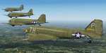
This folder contains repaints for version 3.14 of the Douglas C-47 by Manfred Jahn and colleagues in the colors of 4 aircraft of the 442nd TCG, based in airfield B24 St Andre de l'Eure in March 1945. Included are C-47A-15-DK 42-92879 J7-T of the 303th TCS, C-47A-20-DK 42-93717 V4-F "Carolina Queen" of the 304th TCS, C-47A-80-DL 43-15064 4J-O "Lady Beth" of the 305th TCS and C-53D-DO 42-68840 7H-P "Precious Cargo" of the 306th TCS. Due to the lack of adequate photo material of 442nd aircraft, I have been creative with some of these paints. Repaint by Jan Kees Blom for Manfred Jahn's C-47 version 3.14, based on the paintkit by Gman5250.
| Filename: | Douglas_C47s_of_the_44nd_TCG.zip |
| License: | Freeware |
| Added: | 23rd November 2020, 20:15:20 |
| Downloads: | 151 |
| Author: | Jan Kees Blom |
| Size: | 36.08 MB |
| Category: Flight Simulator 2004 - Aircraft Repaints, Textures and Modifications | |
| Wings of Power A6M5 - Planes of Fame A6M5 |
|
File Description:
Airshow clean A6M5 for the Wings of Power A6M5
The original that this repaint is based on is one of the "Planes of Fame Collection".
Manufactured in May 1943, Zero No 61-120 was the 2,357th aircraft of its type to come off the Nakajima production line and was first assigned to the 261st Japanese Naval Air Corps (JNAC) under the command of LtCdr Takatora Ueda on the Japanese home island of Honshu. Within a few months the unit moved to Iwo Jima Island for air defense duties and, in March 1944, was reassigned to the air defense of the islands of Saipan, Tinian, Rota and Palau. Under the command of Capt Ibusuki, Zero No 61-120 and the 261st JNAC operated from Asilito Airfield on Saipan until the island was invaded by US Marines.
| Filename: | Wings_of_Power_A6M5__Planes_of_Fame_A6M5.zip |
| License: | Freeware |
| Added: | 19th July 2006, 20:20:18 |
| Downloads: | 581 |
| Author: | Martin Catney |
| Size: | 3.79 MB |
| Category: Flight Simulator X - AFCAD Files | |
| KMSP - Minneapolis-St. Paul Intl |
|
File Description:
Building on the work of Carlyle Sharpe, this file set updates Minneapolis-St. Paul Intl Airport adding runway 17/35 along with other features. The west end of the airfield now has default buildings representing the facilities for Mesaba, Sun Country and Champion Air along with the west-end cargo-ops. Buildings have been removed from the runway 35 end of 17/35 as they were relocated to the L5 apron. This set includes a reworked set of approaches based in part on what was in the FSX default and also the work Jim Vile did for fs9 used here by permission and adjusted for FSX with a few additions. As a result the star runway technique is in use. Please consult the readme for proper operation. Additional airport detail scenery is also provided.
| Filename: | KMSP__MinneapolisSt_Paul_Intl.zip |
| License: | Freeware, limited distribution |
| Added: | 25th December 2007, 05:15:14 |
| Downloads: | 2,009 |
| Author: | John Lupori |
| Size: | 40.74 KB |
| Category: Flight Simulator 2004 - Scenery | |
| Alaska South Slope 9; Wales IWK |
|
Images related to this file:
File Description:
There are four main northwestern Alaska towns which are serviced by Alaska Airlines, and from which local flights spread out. The northernmost is Barrow. Southwest of Barrow is Kotzebue, then Nome, and the furthest south is Bethel (not yet made). This is the second in a series for local flights from Nome, and it is on the furthermost mainland western point of Alaska, Wales IWK. It is 110 miles northwest of Nome and on the eastern shore of the Bering Strait, with a view of the two Diomede Islands. Wales is a small village with a population of only around 145, strung along the beach on a single road. The airfield is at the northwestern end of the village, with a runway of 4,500 feet of lit gravel aligned 35-17 and an apron at the southern end. There are scheduled flights by the usual Era and Bering Air, both of them originating in Nome and also visiting Shishmaref. The AI includes these flights along with Northern Air Cargo and GA. The runway is just long enough to accomodate a DC6 (as is Shishmaref) and I have revised the AI to include this, along with a revision of the parking at Shishmaref. To the southeast of Wales is Tin City, which was built as a base for the support of radar on the hills between the two. The radar is now automatic and unmanned and the base is unused except for the annual maintenance and fuel supply; I have left the airfield untouched but I have added the hilltop radar and the remains of the cable lift, which was used to get the material for the original station up to the top from the beach below.
| Filename: | Alaska_South_Slope_9_Wales_IWK.zip |
| License: | Freeware, limited distribution |
| Added: | 22nd October 2016, 01:26:24 |
| Downloads: | 569 |
| Author: | Roger Wensley |
| Size: | 3.77 MB |
© 2001-2026 AVSIM Online
All Rights Reserved
Privacy Policy |