
Where Flight Simulation Enthusiasts Gather from Around the World!
AVSIM Library - Search Results

| Category: Flight Simulator 2004 - Utilities | |
| Kneeboard Tool v1.0 |

|
File Description:
Kneeboard Tool v1.0 for FS2004 -
This is a small tool that adds the following functions in the FS Kneeboard window:
audio check-list playing, navigation charts display, airport informations,
temperature and pressure unit converter, runway circuit heading calculator,
notepad for clearences and frequencies. Freeware by Lionel Selosse.
| Filename: | Kneeboard_Tool_v10.zip |
| License: | Freeware, limited distribution |
| Added: | 15th August 2004, 23:13:30 |
| Downloads: | 9,996 |
| Author: | Lionel Selosse |
| Size: | 2.31 MB |
| Category: Fly! II - Aircraft | |
| Scottish Aviation Twin Pioneer |
|
File Description:
This model of the Scottish Aviation Twin Pioneer was produced using Truespace 4.0 and Chris Wallace's 3ds to S3d converter. It features fowler flaps and fullspan leading edge devices, opening main entry door. Landing can be challenging.
I hope it gives added enjoyment to your simming.
| Filename: | Scottish_Aviation_Twin_Pioneer.zip |
| License: | Freeware, limited distribution |
| Added: | 9th June 2010, 02:12:59 |
| Downloads: | 372 |
| Author: | Roger Mazengarb |
| Size: | 6.31 MB |
| Category: Flight Simulator 2004 - Scenery | |
| Sierra Nevada Mesh. |
|
File Description:
Terrain mesh from SRTM 3 arc second (90m) data for Sierra Nevada Mountains.
This file covers the area of latitude N35-39 and longitude W117-119. Its lenght roughly from Bakersfield California to Reno Nevada, and width from the edge of Death Valley to Fresno.
| Filename: | Sierra_Nevada_Mesh.zip |
| License: | Freeware |
| Added: | 4th January 2004, 20:54:47 |
| Downloads: | 5,675 |
| Author: | Bart Dylkiewicz |
| Size: | 15.86 MB |
| Category: Flight Simulator 2002 - Scenery | |
| Quebec Terrain Mesh (2) |
|
File Description:
New resolution (76m) terrain mesh of province of Quebec, Canada, covering longitude W58 to W80 and latitude N45 to N53. This resolution terrain mesh is based on SRTM-3 (90m) digital elevation models, resampled to Lod of 09 (76m). Five parts: qclod09a.zip, qclod09b.zip, qclod09c.zip, qclod09d.zip, qclod09e.zip.
| Filename: | Quebec_Terrain_Mesh_2.zip |
| License: | Freeware, limited distribution |
| Added: | 20th March 2003, 14:54:09 |
| Downloads: | 5,136 |
| Author: | Gilles Gauthier |
| Size: | 21.45 MB |
| Category: Flight Simulator 2002 - Scenery | |
| Quebec Terrain Mesh (3) |
|
File Description:
New resolution (76m) terrain mesh of province of Quebec, Canada, covering longitude W58 to W80 and latitude N45 to N53. This resolution terrain mesh is based on SRTM-3 (90m) digital elevation models, resampled to Lod of 09 (76m). Five parts: qclod09a.zip, qclod09b.zip, qclod09c.zip, qclod09d.zip, qclod09e.zip.
| Filename: | Quebec_Terrain_Mesh_3.zip |
| License: | Freeware, limited distribution |
| Added: | 20th March 2003, 14:54:48 |
| Downloads: | 5,047 |
| Author: | Gilles Gauthier |
| Size: | 21.94 MB |
| Category: Flight Simulator 2002 - Scenery | |
| Quebec Terrain Mesh (4) |
|
File Description:
New resolution (76m) terrain mesh of province of Quebec, Canada, covering longitude W58 to W80 and latitude N45 to N53. This resolution terrain mesh is based on SRTM-3 (90m) digital elevation models, resampled to Lod of 09 (76m). Five parts: qclod09a.zip, qclod09b.zip, qclod09c.zip, qclod09d.zip, qclod09e.zip.
| Filename: | Quebec_Terrain_Mesh_4.zip |
| License: | Freeware |
| Added: | 20th March 2003, 18:22:00 |
| Downloads: | 5,431 |
| Author: | Gilles Gauthier |
| Size: | 23.33 MB |
| Category: Flight Simulator 2002 - Scenery | |
| Quebec Terrain Mesh (5) |
|
File Description:
New resolution (76m) terrain mesh of province of Quebec, Canada, covering longitude W58 to W80 and latitude N45 to N53. This resolution terrain mesh is based on SRTM-3 (90m) digital elevation models, resampled to Lod of 09 (76m). Five parts: qclod09a.zip, qclod09b.zip, qclod09c.zip, qclod09d.zip, qclod09e.zip.
| Filename: | Quebec_Terrain_Mesh_5.zip |
| License: | Freeware, limited distribution |
| Added: | 20th March 2003, 18:59:53 |
| Downloads: | 5,637 |
| Author: | Gilles Gauthier |
| Size: | 18.93 MB |
| Category: Miscellaneous Files - General Utilities | |
| AgimSearch (Airport General Information Search) |
|
Images related to this file:
File Description:
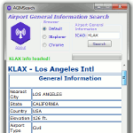
Airport General Information Search provides information such as,
General Info: Nearest City, Country, Elevation, Airport Type, Operation Type, Time Zone, Latitude, Longitude.
Airport Info: Heading, Length, Width, Altitude, Surface, ILS Frequency.
Communication Info: ATIS, APP, DEP, GND, TWR.
NavAid Info and Current Weather
AGIMSearch used data courtesy of smithplanet
| Filename: | AgimSearch_Airport_General_Information_Search.zip |
| License: | Freeware |
| Added: | 17th August 2017, 07:12:41 |
| Downloads: | 440 |
| Author: | Christopher Hall |
| Size: | 353.36 KB |
| Category: Flight Simulator 2002 - Scenery | |
| Quebec Terrain Mesh (1/5) |
|
File Description:
Re-uploaded file. New resolution (76m) terrain mesh of province of Quebec, Canada, covering longitude W58 to W80 and latitude N45 to N53. This resolution terrain mesh is based on SRTM-3 (90m) digital elevation models, resampled to LOD of 09 (76m). Five parts: qclod09a.zip, qclod09b.zip, qclod09c.zip, qclod09d.zip, qclod09e.zip.
| Filename: | Quebec_Terrain_Mesh_15.zip |
| License: | Freeware, limited distribution |
| Added: | 11th May 2010, 21:26:59 |
| Downloads: | 6,750 |
| Author: | Gilles Gauthier |
| Size: | 18.26 MB |
| Category: AVSIM File Library - Navigation and ATC | |
| vasFMC to MS Flight Simulator flightplan converter V2.8 (fmc2PLN) |
|
File Description:
New version! This tool lets you convert saved vasFMC flightplans into native MSFS flightplans. This way you can use the standard GPS that comes with FS9/FSX with up to date navigational information for autopilot navigation and for offline ATC using the built-in ATC in MSFS. Works with both FS9 (=FS2004) and FSX. Works with both vasFMC V1.10 and V2. This version now supports the extended flightplan capabilities of FSX compared to FS9 (there is no need to have an airport at the end of the route for FSX export anymore so that you can add go-around fixes at the end; but FS9 is still supported of course), and some minor bugs have been fixed, too. Please note that Alex Wemmer's software vasFMC will be needed (www.vas-project.org). Please be advised that now there is a tool for the other way round conversions available as well here on AVSIM (PLN2fmc).
| Filename: | vasFMC_to_MS_Flight_Simulator_flightplan_converter.zip |
| License: | Freeware |
| Added: | 20th January 2009, 23:02:12 |
| Downloads: | 1,114 |
| Author: | Jens-Arne Reumschuessel |
| Size: | 492.66 KB |
© 2001-2026 AVSIM Online
All Rights Reserved
Privacy Policy |