
Where Flight Simulation Enthusiasts Gather from Around the World!
AVSIM Library - Search Results

| Category: Flight Simulator X - Scenery | |
| Cairo City X 1.0 |

|
File Description:
This freeware Scenery is made to let Cairo looking a little bit more realistic. In a very very friendly framerate mode! Requires the linked file!
- Corrected coastline of the nile and the elevation
- Corrected the default buildings in Cairo
- Corrected Gizah plateau
- Added trees along the Nile alleys in the city
- Added city parks and famous places
- Added all new Satelites Citys around Cairo
- Added many missed wather channel
- All road and rail bridges added crossing river nile
- Corrected railroads
| Filename: | Cairo_City_X_10.zip |
| License: | Freeware, limited distribution |
| Added: | 9th January 2012, 01:05:28 |
| Downloads: | 13,294 |
| Author: | Mathias Schindler |
| Size: | 4.87 MB |
| Category: Flight Simulator X - Scenery | |
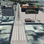
| Dragon Peaks AFB (AW56), South Africa |
|
Images related to this file:
File Description:
A Gmax representation of Dragon Peaks Air Force Base also referred to as CL van Wyngaard Airfield (fictional ID: AW56), Northern Drakensberg, South Africa withphotoreal textures.
AFB Dragon Peaks is a small airfield nestled between the hills on the slopes of the Northern Drakensberg of South Africa. The airfield is situated only a few hundred meters from the Dragon Peaks Mountain resort as well as the home of the famous Drakensberg Boys Choir.
The grass runway is aligned 06/24 and 458m long and sits at an elevation of 3 986ft.
| Filename: | Dragon_Peaks_AFB_AW56_South_Africa.zip |
| License: | Freeware |
| Added: | 18th November 2017, 16:04:29 |
| Downloads: | 595 |
| Author: | Kobus van Wyk and Frits Beyer |
| Size: | 9.52 MB |
| Category: Flight Simulator X - Scenery | |
| Knoxville Municipal Airport KOXV |
|
Images related to this file:
File Description:
FSX Scenery - The Knoxville Municipal Airport, (KOXV) renamed Jim Bellamy Field, serves the greater Knoxville community and the surrounding areas of Marion County, Iowa. The airport is comprised of 120 acres, and is located at the southern edge of Knoxville, adjacent to the Highway 14 & Highway 5/92 interchange. The 4,000 foot (by 75 foot) single runway is constructed of concrete, with parallel taxiway. The facility is at an elevation of 928 feet at a distance of about 2 miles from Knoxville. Created for your flying pleasure by John B Loney, Jr.
| Filename: | Knoxville_Municipal_Airport_KOXV.zip |
| License: | Freeware, limited distribution |
| Added: | 13th October 2012, 17:18:20 |
| Downloads: | 540 |
| Author: | John B. Loney, Jr. |
| Size: | 31.45 MB |
| Category: Flight Simulator 2004 - Scenery | |
| Joe Foss-Sioux Falls Regl KFSD |
|
File Description:
FS2004 Scenery-Joe Foss Field - Sioux Falls Regional Airport (KFSD) serves Sioux Falls and Minnehaha County and is owned by Sioux Falls Regional Airport Authority. The airport has more than one runway. The longest is a paved runway extending 8999 feet. The facility is at an elevation of 1429 feet at a distance of about three miles from Sioux Falls. South Dakota's 114th Fighter Group, nicknamed the Lobos, is stationed at Joe Foss Field, Sioux Falls, SD. Created entirely with EZ Scenery. New AFCAD2 file with AI flight plans. By John B. Loney, Jr.
| Filename: | Joe_FossSioux_Falls_Regl_KFSD.zip |
| License: | Freeware |
| Added: | 17th July 2006, 01:30:18 |
| Downloads: | 2,309 |
| Author: | John B. Loney, Jr. |
| Size: | 1.39 MB |
| Category: Flight Simulator 2004 - Scenery | |
| Reservoirs and Lakes of Lesotho and Western Natal, South Africa |
|
File Description:
Replacement files for water bodies of eastern South Africa, in and near the Drakensberg Range (S28.1-29.5 E28.3-30.0). Natural and man-made lakes are now in their accurate position and elevation. Includes the Katse Dam reservoir in Lesotho as well as about 100 smaller lakes in Lesotho and western Natal not present in the FS default scenery. Based on a watermask derived from Landsat 7 ETM+ satellite data and compiled with a beta version of Jim Keir's "Slartibartfast" utility. Meant to be used with the Aeroworx SRTM LOD9 South Africa mesh.
| Filename: | Reservoirs_and_Lakes_of_Lesotho_and_Western_Natal_.zip |
| License: | Freeware, limited distribution |
| Added: | 8th May 2004, 02:43:38 |
| Downloads: | 6,202 |
| Author: | Holger Sandmann, Aeroworx |
| Size: | 464.27 KB |
| Category: Flight Simulator X - Scenery | |
| LGMM2 Athinaiko Airport |
|
Images related to this file:
File Description:
AS REAL AS IT GETS.
Athinaiko Airport.
Combined with AthensBlds2.
This revamped and completely refurbished version contains exclusion
polygons and ELEVATION CHANGE FILES which I forgot to upload with the original version.
In this version I have included a detailed photoscenery files of the surrounding area in case you haven't installed my Athens3 and Athens4 photoscenery.( It would work with or without my Athens photoscenery).
ALSO, I have combined a revamped and totally reworked AthensBlds scenery containing 135 original buildings in the surrounding area.
(A lot of work indeed)
IMPORTANT: See details bellow for installation instructions.
| Filename: | LGMM2_Athinaiko_Airport.zip |
| License: | Freeware |
| Added: | 2nd July 2011, 03:39:57 |
| Downloads: | 579 |
| Author: | Angelo Tassoglou |
| Size: | 149.52 MB |
| Category: Flight Simulator 2004 - Scenery | |
| Joplin Regional Airport |
|
Images related to this file:
File Description:
FS9 Scenery - Joplin Regional Airport (IATA: JLN, ICAO: KJLN) is a public airport located four miles (6 km) north of the central business district (CBD) of Joplin, a city in Jasper County, Missouri, USA. The airport covers 970 acres (393 ha) and has three runways. It offers commercial airline service subsidized by the Essential Air Service program. Joplin Regional Airport is owned by the City Of Joplin. The longest runway is a paved runway extending 6503 feet. The facility is at an elevation of 981 feet. This scenery was created using Instant Scenery by John B. Loney, Jr.
| Filename: | Joplin_Regional_Airport.zip |
| License: | Freeware, limited distribution |
| Added: | 30th December 2009, 21:53:28 |
| Downloads: | 618 |
| Author: | John B. Loney, Jr. |
| Size: | 1019.39 KB |
| Category: Flight Simulator 2002 - Scenery | |
| Lower Mainland of Southern British Columbia, Canada Mesh |
|
File Description:
New high-resolution (76-m) terrain mesh of the Lower Mainland area of British Columbia, covering a 4-degree longitude by 1.5-degree latitude transect (N48.5-50, W120-124) from Bowen Island to Manning Park. It gives a much better representation of the subtle terrain in Vancouver and the Fraser Valley, the beautiful North Shore Mountains, and the extreme topography of the North Cascades southeast of Chilliwack. Made from 100-m digital elevation data, resampled to LOD9 (76-m) horizontal spacing. Designed as an add-on to my LOD7 mesh of the entire province but can be used independently. By Holger Sandmann.
| Filename: | Lower_Mainland_of_Southern_British_Columbia_Canada.zip |
| License: | Freeware, limited distribution |
| Added: | 20th January 2003, 18:17:35 |
| Downloads: | 6,160 |
| Author: | Holger Sandmann |
| Size: | 8.29 MB |
| Category: Civil Flight Simulators - Looking Glass Flight Unlimited 3 | |
| UK South Real Airports Definitions |
|
File Description:
Thanks to the hard work of many, we now have a lot of the major UK airports to fly to.
This set of packages for the UK-South region gives you basic definitions for many of
the lesser airfields in this region. It is not intended that these airports are finished
products by any means, although several of them have basic layouts. It is mostly intended
as a guide for future development, but most of the airports here can be flown into
sucessfully. Those that are not so good can be fixed later by classification and elevation updates.
| Filename: | UK_South_Real_Airports_Definitions.zip |
| License: | Freeware |
| Added: | 13th October 2003, 05:18:10 |
| Downloads: | 390 |
| Author: | David Reeves |
| Size: | 143.42 KB |
| Category: Flight Simulator 2004 - Scenery | |
| Panama City - Bay Cty 2 |
|
File Description:
FS2004 Scenery-Panama City-Bay Co Intl Airport (KPFN) serves Panama City and Bay County and is owned by Panama City-Bay Co Arpt Dist. The airport has more than one runway. The longest is a paved runway extending 6304 feet. The facility is at an elevation of 21 feet at a distance of about 3 miles from Panama City. Version 2 includes dynamic scenery, Totally redone static scenery taken from Google Earth Satellite Images. All Runways in use. Created with FSDS2.10, Rwy12, EZ Scenery, with a new AFCAD2 file and Traffic Tools. FSDS2 scenery textures included. (Previous version had 1186 downloads)
| Filename: | Panama_City__Bay_Cty_2.zip |
| License: | Freeware |
| Added: | 27th February 2006, 00:48:28 |
| Downloads: | 3,313 |
| Author: | John B. Loney, Jr. |
| Size: | 1000.19 KB |
© 2001-2026 AVSIM Online
All Rights Reserved
Privacy Policy |