
Where Flight Simulation Enthusiasts Gather from Around the World!
AVSIM Library - Search Results

| Category: Prepar3D V1-4 - Scenery Design | |
| Sao Tome International Airport - FPST |

|
Images related to this file:
File Description:
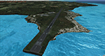
Sao Tome International Airport (FPST) v0.1 BETA
This release of Sao Tome International Airport (FPST) is for FSX and P3d v4.5.
This is a Beta release. Included:
- More realistic elevation/shoreline
- New Photoreal Ground Poly
- Custom 3d models (Old/New Terminal, Hangars, Tower)
- New Landclass for Island (FSX only)
Missing from this Beta release:
- Some airport buildings
- More detail,3d grass, the abandoned Connie etc
- Night textures! I recommend that you fly at day time!
| Filename: | Sao_Tome_International_Airport__FPST.zip |
| License: | Freeware |
| Added: | 31st May 2020, 20:52:32 |
| Downloads: | 1,038 |
| Author: | C Diver |
| Size: | 81.77 MB |
| Category: Flight Simulator X - AFCAD Files | |
| FKYS - Yaounde Nsimalen Intl Airport - Cameroon |
|
File Description:
Yaounde Nsimalen International Airport (French: Aeroport international de Yaounde-Nsimalen) (IATA: NSI, ICAO: FKYS) is an airport serving Yaounde, the capital of Cameroon. The airport is located south of Yaounde, near Nsimalen in Cameroon's Centre Province. In 2004, the airport served 190,487 passengers.
Airport elevation and runway were corrected also the jetways, aprons and buildings. Airport charts courtesy of www.ais-asecna.org/en/ad/ad2.htm.
This work is dedicated to West Wind Airlines.
| Filename: | FKYS__Yaounde_Nsimalen_Intl_Airport__Cameroon.zip |
| License: | Freeware |
| Added: | 24th May 2013, 22:41:40 |
| Downloads: | 1,329 |
| Author: | Anwar Gonzalez |
| Size: | 1.16 MB |
| Category: Flight Simulator 2004 - Scenery | |
| AI-China China Scenery Package |
|
File Description:
This package includes all Chinese airports, including the new ZSPD (with 2 runways) and the ZGGG also built in Huadu GuangZhou. These sceneries are little bit more advanced than the default but obviously do not have the quality of a payware scenery. This package also include the high elevation airports such as ones in Tibet. If you have any problems, please contact the developers whos email will be in the package readme.
| Filename: | AIChina_China_Scenery_Package.zip |
| License: | Freeware |
| Added: | 6th June 2006, 14:21:40 |
| Downloads: | 26,428 |
| Author: | AI-China |
| Size: | 12.69 MB |
| Category: Flight Simulator 2002 - Scenery Design | |
| LandCalc2 |
|
File Description:
This package is for FS2002 and CFS2 LandClass and photoreal scenery designers.
LandCalc2 is a utility that will derive all the necessary information needed to create LandClass BGLs using CUSTOM textures, as outlined in the FS2002 Terrain SDK. It also gives latitude, longitude and ground elevation. All this is done automatically, through the use of FSUIPC.
FSUIPC must be installed as a module to FS2002, or CFS2, in order for this utility to work.
| Filename: | LandCalc2.zip |
| License: | Freeware |
| Added: | 22nd October 2002, 21:48:58 |
| Downloads: | 1,196 |
| Author: | Richard Ludowise |
| Size: | 233.2 KB |
| Category: Flight Simulator 2004 - Scenery | |
| FS2004 Scenery - Elizabeth Field 0B8 |
|
File Description:
FS2004 Scenery - Elizabeth Field Airport (0B8) serves Fishers Island and Suffolk County Long Island, N.Y. and is owned by Town Of Southold. The airport has more than one runway. The longest is a paved runway extending 2328 feet. The facility is at an elevation of 9 feet. The scenery objects were placed using Instant Scenery using the EZ Scenery libraries. Instructions for Ultimate Terrain users included. Created in collaboration with Ray Lunning by John B. Loney, Jr.
| Filename: | FS2004_Scenery__Elizabeth_Field_0B8.zip |
| License: | Freeware, limited distribution |
| Added: | 21st December 2007, 04:36:10 |
| Downloads: | 814 |
| Author: | John B. Loney, Jr. |
| Size: | 219.35 KB |
| Category: Flight Simulator 2004 - Scenery | |
| Millard Municipal Airport, NE |
|
File Description:
FS2004 Scenery-Millard Airport (KMLE) serves Omaha and Douglas County and is owned by Omaha Arpt Authority. The paved runway extends for 3800 feet. The facility is at an elevation of 1050 feet at a distance of about 7 miles from Omaha. Dynamic scenery via Lago's FSE. Rwy12 and EZ Scenery along with FSDS3 also used. Textures for FSDS3 included in download. Modified AFCAD2 file and AI traffic via Traffic Tools. By John B. Loney, Jr.
| Filename: | Millard_Municipal_Airport_NE.zip |
| License: | Freeware |
| Added: | 14th March 2006, 04:04:43 |
| Downloads: | 600 |
| Author: | John B. Loney, Jr. |
| Size: | 858.51 KB |
| Category: Flight Simulator 2004 - Scenery | |
| Brewster Field KHDE |
|
File Description:
FS2004 Scenery-Brewster Field Airport (KHDE) serves Holdrege and Phelps County and is owned by Holdrege Airport Auth. The airport has more than one runway. The longest is a paved runway extending 4700 feet. The facility is at an elevation of 2313 feet at a distance of about 2 miles from Holdrege. Created using FSDS3, EZ Scenery, Rwy12 and Lago's FSE. Modified AFCAD2 file and AI traffic with Traffic Tools. For interesting story behind facility, read readme file.
| Filename: | Brewster_Field_KHDE.zip |
| License: | Freeware |
| Added: | 27th January 2006, 05:44:15 |
| Downloads: | 455 |
| Author: | John B. Loney, Jr. |
| Size: | 552.61 KB |
| Category: Flight Simulator 2004 - Scenery | |
| Alexandria Airport N85 |
|
File Description:
FS2004 Scenery - Alexandria Airport (N85) serves Pittstown and Hunterdon County in New Jersey and is owned by Leah Fritsche. The airport has more than one runway. The longest is a paved runway extending 2550 feet. The facility is at an elevation of 480 feet at a distance of about 2 miles from Pittstown. Alexandria Field is home to over 100 planes, and has an active flight school and maintenance shop. Created with EZ Scenery. EZ Scenery libraries required.
| Filename: | Alexandria_Airport_N85.zip |
| License: | Freeware, limited distribution |
| Added: | 17th June 2007, 23:39:52 |
| Downloads: | 692 |
| Author: | John B. Loney, Jr. |
| Size: | 943.55 KB |
| Category: Flight Simulator 2004 - Scenery | |
| Sumter Municipal Airport KSMS |
|
Images related to this file:
File Description:
FS2004 Scenery - Sumter Municipal Airport (IATA: SMS, ICAO: KSMS, FAA LID: SMS) Sumter, South Carolina, United States, serves Sumter and Sumter County and is owned by the City & County Of Sumter. The airport has more than one runway. The longest is a paved runway extending 5500 feet. The facility is at an elevation of 183 feet at a distance of about 4 miles from Sumter. Created with Instant Scenery. For FSX version, see ksms_fsx.zip. By John B. Loney, Jr.
| Filename: | Sumter_Municipal_Airport_KSMS.zip |
| License: | Freeware, limited distribution |
| Added: | 2nd November 2009, 20:00:23 |
| Downloads: | 203 |
| Author: | John B. Loney, Jr. |
| Size: | 463.24 KB |
| Category: Flight Simulator 2004 - Scenery | |
| Airborne Airpark KILN |
|
File Description:
FS2004 Scenery Airborne Airpark (KILN) Wilmington, Oh. The airport serves Wilmington and Clinton County and is owned by DHL (Was formerly owned by Airborne Express Inc.. The airport has more than one runway. The longest is a paved runway extending 10701 feet. The facility is at an elevation of 1077 feet at a distance of about 2 miles from Wilmington. Designed entirely with Rwy_12 and EZ Scenery. New AFCAD2 file and AI Traffic. By John B. Loney, Jr.
| Filename: | Airborne_Airpark_KILN.zip |
| License: | Freeware |
| Added: | 11th June 2006, 05:00:33 |
| Downloads: | 1,933 |
| Author: | John B. Loney, Jr. |
| Size: | 381.11 KB |
© 2001-2026 AVSIM Online
All Rights Reserved
Privacy Policy |