
Where Flight Simulation Enthusiasts Gather from Around the World!
AVSIM Library - Search Results

| Category: Flight Simulator 2002 - AI Flight Plans | |
| Airports of the World Database |

|
File Description:
Airports of the World Database
Well, here is a comprehensive database of nearly 1,000 of the world's major airports. The database includes airport 4-letter code, 3-letter code, airport name, city name, country, airport elevation, runway length and latitude/longitude. Great for AI Traffic.
All we ask for is that the source is credited wherever it is possible.
Darren Paul Rhodes/ Victor Cabral
| Filename: | Airports_of_the_World_Database.zip |
| License: | Freeware |
| Added: | 3rd October 2002, 00:40:42 |
| Downloads: | 1,621 |
| Author: | Darren Paul Rhodes/ Victor Cabral |
| Size: | 145.79 KB |
| Category: Flight Simulator 2004 - Scenery | |
| Opa Locka Airport (KOPF) |
|
File Description:
FS2004 Scenery-Opa Locka Airport (KOPF) serves Miami and Dade County and is owned by Dade County Aviation Dept. The airport has more than one runway. The longest is a paved runway extending 8002 feet. The facility is at an elevation of 10 feet at a distance of about 10 miles from Miami. This scenery was created with FSDS2, Rwy12, FSE, AFCAD2 and Traffic Tools2x. Textures included.
| Filename: | Opa_Locka_Airport_KOPF.zip |
| License: | Freeware |
| Added: | 11th September 2005, 23:00:11 |
| Downloads: | 2,104 |
| Author: | John B. Loney, Jr. |
| Size: | 1.27 MB |
| Category: Flight Simulator 2004 - Scenery | |
| Hammonton Municipal, New Jersey (N81) |
|
File Description:
FS2004 Scenery-Hammonton Municipal Airport (N81) serves Hammonton and Atlantic County and is owned by the Town of Hammonton. The paved runway extends for 3,004 feet. The facility is at an elevation of 69 feet at a distance of about 3 miles from Hammonton. Dynamic scenery created with Lago's FSE. FSDS3 textures included. Modified AFCAD2 file. AI traffic. Need EZ Scenery and Rwy12 libraries.
| Filename: | Hammonton_Municipal_New_Jersey_N81.zip |
| License: | Freeware |
| Added: | 4th March 2006, 00:33:51 |
| Downloads: | 1,278 |
| Author: | John B. Loney, Jr. |
| Size: | 637.35 KB |
| Category: Civil Flight Simulators - Looking Glass Flight Unlimited 3 | |
| Apex Airpark fix for "Seattle 2008" users |
|
File Description:
Apex Airpark was not originally part of this set however, the old airport and packages were included. This means that the runway is not usable, except by 4WDs! Those of you wanting to use Apex should download and install this update. This update includes elevation, airport and packages. You will need to use GeoTilesViewer (included) but it's pretty simple ;-)
As with everything, this is freeware.
| Filename: | Apex_Airpark_fix_for_Seattle_2008_users.zip |
| License: | Freeware |
| Added: | 2nd January 2008, 04:47:20 |
| Downloads: | 93 |
| Author: | Jon Point |
| Size: | 193.9 KB |
| Category: Flight Simulator 2004 - Scenery | |
| KEKM - Elkhart Municipal Airport - Elkhart, Indiana |
|
Images related to this file:
File Description:
FS2004 Scenery - Elkhart Municipal Airport serves Elkhart and Elkhart County and is owned by the City Of Elkhart, Indiana. The airport has more than one runway. The longest is a paved runway extending 6500 feet. The facility is at an elevation of 778 feet at a distance of about 3 miles from Elkhart. For the enjoyment of the FS community, by John B. Loney, Jr.
| Filename: | KEKM__Elkhart_Municipal_Airport__Elkhart_Indiana.zip |
| License: | Freeware, limited distribution |
| Added: | 22nd March 2013, 19:02:41 |
| Downloads: | 386 |
| Author: | John B. Loney, Jr. |
| Size: | 77.88 MB |
| Category: Flight Simulator 2004 - Scenery | |
| Vandenberg Airport (KVDF) |
|
Images related to this file:
File Description:
FS2004 Scenery - Vandenberg Airport (KVDF) serves Tampa and Hillsborough County and is owned by Hillsborough Co Avia Auth. The paved runway extends for 3260 feet. The facility is at an elevation of 20 feet at a distance of about 6 miles from Tampa. Requires Nova, NovaGold and NovaSim Textures. Created with FSDS2, Rwy12 and Lago's FSE. AFCAD2 and Traffic Tools a must. By John B. Loney, Jr.
| Filename: | Vandenberg_Airport_KVDF.zip |
| License: | Freeware, limited distribution |
| Added: | 17th May 2010, 22:23:20 |
| Downloads: | 1,357 |
| Author: | John B. Loney, Jr. |
| Size: | 1.15 MB |
| Category: Flight Simulator 2004 - AFCAD Files | |
| Samedan LSZS Switzerland |
|
File Description:
AFCAD file for FS2004 default scenery of Samedan LSZS airport near St. Moritz in southeast Switzerland.
Update by permission to Andreas Hegi scenery (lszs2004.zip)
Removes approach & night lighting as in the real airport.
Samedan is Europe's highest elevation airport (5600 ft.) with surrounding terrain of the swiss alps.
There is no night lighting at this airport. Visual approach vicinity charts included.Update to lszs2004.zip
| Filename: | Samedan_LSZS_Switzerland.zip |
| License: | Freeware, limited distribution |
| Added: | 19th March 2010, 09:08:32 |
| Downloads: | 522 |
| Author: | Kyprianos Biris |
| Size: | 689.29 KB |
| Category: Flight Simulator X - Scenery | |
| Richmond Municipal Airport KRID |
|
Images related to this file:
File Description:
FSX Scenery - Richmond Municipal Airport (KRID), Richmond, IN serves Richmond and Wayne County and is owned by Richmond Boac. The airport has more than one runway. The longest is a paved runway extending 5200 feet. The facility is at an elevation of 1140 feet at a distance of about 5 miles from Richmond. Created for your flying pleasure with Instant Scenery 2 by John B. Loney, Jr.
| Filename: | Richmond_Municipal_Airport_KRID.zip |
| License: | Freeware, limited distribution |
| Added: | 3rd August 2010, 22:22:55 |
| Downloads: | 674 |
| Author: | John B. Loney, Jr. |
| Size: | 5.1 MB |
| Category: Flight Simulator X - Scenery | |
| Kasane (FBKE), Botswana V2 |
|
File Description:
Elevation fix, corrected airport layout, scenery enhancements and GA AI traffic.
New in Version 2:
I try to learn modeling and FSX Materials to build my own airport buildings. I hope it's acceptable for the first try.
Furthermore, heading of the windsocks has been corrected, tower view has been corrected, minor improvements to the scenery and i made a freeway traffic exclude for the airport area.
| Filename: | Kasane_FBKE_Botswana_V2.zip |
| License: | Freeware |
| Added: | 18th January 2009, 17:46:56 |
| Downloads: | 1,875 |
| Author: | Nils Besemer |
| Size: | 4.14 MB |
| Category: Flight Simulator X - Scenery | |
| FAPF - Piet Retief Airfield - South Africa |
|
Images related to this file:
File Description:
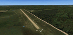
Gmax representation of Piet Retief Airfield (FAPF), Mpumalanga, South Africa with photoreal textures. Piet Retief airfield is a small airfield with a grass/dirt runway measuring 1 371m. The airfield is situated between the trees of the lush Sappi forests between the town of Piet Retief and the Swaziland border at an elevation of 4 420ft. There is an NDB for a "Breakcloud" procedure onto rwy 15.
| Filename: | FAPF__Piet_Retief_Airfield__South_Africa.zip |
| License: | Freeware |
| Added: | 17th August 2014, 22:03:31 |
| Downloads: | 1,096 |
| Author: | Kobus van Wyk, Aeroworx |
| Size: | 27.17 MB |
© 2001-2026 AVSIM Online
All Rights Reserved
Privacy Policy |