
Where Flight Simulation Enthusiasts Gather from Around the World!
AVSIM Library - Search Results

| Category: Flight Simulator 2004 - Scenery | |
| Carroll County-Tolson KTSO |

|
Images related to this file:
File Description:
FS2004 Scenery - Carroll County-Tolson Airport (KTSO) serves Carrollton and Carroll County, OH USA and is owned by Carroll County Arpt Auth. The paved runway extends for 4300 feet. The facility is at an elevation of 1163 feet at a distance of about one mile from Carrollton. Created with Instant Scenery by John B. Loney, Jr.
| Filename: | Carroll_CountyTolson_KTSO.zip |
| License: | Freeware, limited distribution |
| Added: | 2nd November 2009, 19:59:13 |
| Downloads: | 200 |
| Author: | John B. Loney, Jr. |
| Size: | 409.91 KB |
| Category: Flight Simulator 2004 - AFCAD Files | |
| Sucre SLSU Bolivia |
|
Images related to this file:
File Description:
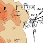
AFCAD file for FS2004 default scenery of Sucre SLSU Juanna A. De Padilla airport in Bolivia.
Brings runway to proper dimensions and adds approach (PAPI) lighting as in the real airport.
High elevation airport (9430 ft.) with surrounding terrain of the Bolivian Andes.
There is no night lighting at this airport. Approach charts included. Recommended mesh terrain: mesh_fermandois003_265585.zip
| Filename: | Sucre_SLSU_Bolivia.zip |
| License: | Freeware, limited distribution |
| Added: | 19th March 2010, 08:55:01 |
| Downloads: | 561 |
| Author: | Kyprianos Biris |
| Size: | 683.9 KB |
| Category: Flight Simulator X - Scenery | |
| Lebanon TerrainX V1.5 |
|
Images related to this file:
File Description:

Lebanon Terrain X V1.5 for FSX by Lebor Simulations, improves the following landscape aspects of Lebanon: Elevation, coastline, waterclass, region class / Population, Snow coverage in winter, vector class for towns around Beirut etc. It also features the major roads of Lebanon with moving traffic.
This scenery package is a MUST have for our scenery OLBAXV1.0
| Filename: | Lebanon_TerrainX_V15.zip |
| License: | Freeware |
| Added: | 3rd February 2013, 05:04:52 |
| Downloads: | 12,040 |
| Author: | Lebor Simulations (Jad Abizeid, Michel Karam) |
| Size: | 26.33 MB |
| Category: Flight Simulator 2004 - Scenery | |
| Blairstown Airport NJ |
|
File Description:
FS2004 Scenery-Blairstown Airport (1N7) in New Jersey, serves Blairstown and Warren County and is owned by Steve Parker (Blair Air). The paved runway extends for 3100 feet. The facility is at an elevation of 372 feet at a distance of about 2 miles from Blairstown. Please read the readme file. Created with EZ Scenery by John B. Loney, Jr.
| Filename: | Blairstown_Airport_NJ.zip |
| License: | Freeware, limited distribution |
| Added: | 25th March 2007, 04:08:18 |
| Downloads: | 793 |
| Author: | John B. Loney, Jr. |
| Size: | 7.01 MB |
| Category: Flight Simulator 2004 - AFCAD Files | |
| Comoros Airports Tower Views and Helipads |
|
File Description:
- FOR USE WITH DEFAULT SCENERY !
- A proper tower view - either "in the control tower room" or "on top of the control tower" - for the 4 airports of Comoros islands.
- Included are two series of AF2_XXXX.bgl files : one for each position of the "tower cam".
- Also included is a text file with the data ( longitude, latitude and elevation ) used to create the views .
| Filename: | Comoros_Airports_Tower_Views_and_Helipads.zip |
| License: | Freeware |
| Added: | 6th July 2004, 14:56:57 |
| Downloads: | 328 |
| Author: | Marc Renaud |
| Size: | 104.89 KB |
| Category: Flight Simulator 2004 - AFCAD Files | |
| Seychelles Airports Tower Views Pack 1 |
|
File Description:
Added a proper "tower view" ( the cam is where it should always have been : in the control tower ! ). Corrections were applied to Coetivy so that airplanes do not take off from the water or the woods anymore ! This package contains 13 AF2_XXXX.bgl files and one text file with the data ( longitude, latitude and elevation ) used to create the tower views.
| Filename: | Seychelles_Airports_Tower_Views_Pack_1.zip |
| License: | Freeware |
| Added: | 29th April 2004, 17:01:59 |
| Downloads: | 437 |
| Author: | Marc Renaud |
| Size: | 10.59 KB |
| Category: Flight Simulator 2004 - Scenery | |
| FS2004 detailed KWYS Yellowstone |
|
File Description:
FS2004 EZ-LAGO KWYS Yellowstone
This detailed scenery replaces my previous KWYS and is FSX ready.
Covers airport and some surrounding area. Area outside of
airport needs FS Global or Abacus Extreme Landscapes for
elevation mesh. LAGO registered version AND free EZ scenery library
necessary for all items to show. If you do not have LAGO
try anyway you can still enjoy it.
| Filename: | FS2004_detailed_KWYS_Yellowstone.zip |
| License: | Freeware |
| Added: | 8th June 2006, 03:00:48 |
| Downloads: | 1,317 |
| Author: | Jimmy R Martin |
| Size: | 711.88 KB |
| Category: Flight Simulator 2004 - Scenery | |
| El Plumerillo Airport (SAME) - Argentina |
|
File Description:
This is very operative airport of El Plumerillo (SAME), in Mendoza, Provincia de Mendoza, Republica Argentina, with all navaids and the objects in the correct place. This is not photorealistic scenery. ONLY FOR FS2004. Building with SceneGenX 1.0 Build 54 by Tom Hiscox and some objects by RWY12.
This scenery fix the MS FS problem with SAMQ (correct elevation but incorrect position).
| Filename: | El_Plumerillo_Airport_SAME__Argentina.zip |
| License: | Freeware |
| Added: | 30th April 2006, 22:06:01 |
| Downloads: | 3,505 |
| Author: | carlos maida |
| Size: | 2.66 MB |
| Category: Flight Simulator X - AFCAD Files | |
| FPST - Sao Tome International Airport - Sao Tome Island |
|
File Description:
Sao Tome International Airport (Portuguese: Aeroporto Internacional de Sao Tome) (IATA: TMS, ICAO: FPST) is an airport located on Sao Tome Island, 5 kilometres (3 mi) from the city of Sao Tome. It is the main airport serving Sao Tome
and Principe. Airport elevation and runway was corrected also the aprons and buildinds.
This work is dedicated to West Wind Airlines.
| Filename: | FPST__Sao_Tome_International_Airport__Sao_Tome_Isl.zip |
| License: | Freeware |
| Added: | 3rd May 2013, 18:42:54 |
| Downloads: | 1,047 |
| Author: | Anwar Gonzalez |
| Size: | 9.24 KB |
| Category: Flight Simulator X - Scenery | |
| KEKM - Elkhart Municipal Airport - Elkhart, Indiana |
|
Images related to this file:
File Description:
Elkhart Municipal Airport serves Elkhart and Elkhart County and is owned by the City Of Elkhart, Indiana. The airport has more than one runway. The longest is a paved runway extending 6500 feet. The facility is at an elevation of 778 feet at a distance of about 3 miles from Elkhart. For the enjoyment of the FS community, by John B. Loney, Jr.
| Filename: | KEKM__Elkhart_Municipal_Airport__Elkhart_Indiana.zip |
| License: | Freeware, limited distribution |
| Added: | 22nd March 2013, 19:01:03 |
| Downloads: | 571 |
| Author: | John B. Loney, Jr. |
| Size: | 86.56 MB |
© 2001-2026 AVSIM Online
All Rights Reserved
Privacy Policy |