
Where Flight Simulation Enthusiasts Gather from Around the World!
AVSIM Library - Search Results

| Category: Flight Simulator X - AFCAD Files | |
| GCFV (corrected) - Fuerteventura, Spain |

|
File Description:
This AFCAD file changes only the elevation of the airport from 140.82 meters to 20 meters which visually seems to be a good compromise with the FSX default scenery. Note: In the original submission of this airport to the AVSIM Library, the GCFV_ADE_DKR_ALT file was omitted.
| Filename: | GCFV_corrected__Fuerteventura_Spain.zip |
| License: | Freeware |
| Added: | 23rd February 2009, 21:14:32 |
| Downloads: | 1,338 |
| Author: | Dan Reynolds |
| Size: | 5.42 KB |
| Category: Flight Simulator X - Scenery | |
| Bellefonte Airport N96 |
|
Images related to this file:
File Description:
FSX Scenery - Bellefonte Airport (N96) serves Bellefonte and Centre County and is owned by John & Marina Elnitski. The paved runway extends for 3600 feet. The facility is at an elevation of 1080 feet at a distance of about 3 miles from Bellefonte. By John B. Loney, Jr.
| Filename: | Bellefonte_Airport_N96.zip |
| License: | Freeware, limited distribution |
| Added: | 27th February 2011, 04:40:55 |
| Downloads: | 365 |
| Author: | John B. Loney, Jr. |
| Size: | 1.69 MB |
| Category: Combat Flight Simulator 1 and 2 - Scenery | |
| CFS2 Coast Pacific |
|
File Description:
CFS2 has no flattening of the coastal areas. This creates mesh problems, as the coastal water will not always be at elevation 0.
These BGLs will correct that problem for the Pacific Theatre. Areas include Hawaii, Japan, Australia, New Zealand, the Western Pacific islands, and SE Asia.
| Filename: | CFS2_Coast_Pacific.zip |
| License: | Freeware |
| Added: | 13th August 2002, 20:30:11 |
| Downloads: | 1,411 |
| Author: | Richard Ludowise |
| Size: | 3.45 MB |
| Category: Civil Flight Simulators - Looking Glass Flight Unlimited 3 | |
| FU3 Outer Terrain GTL Tile Editor v2.0 |
|
Images related to this file:
File Description:
This spreadsheet allows you to view, edit and save changes to the outer terrain's GTL tiles. Tiles are loaded into a 256x256 grid and the 13 default terrain textures are represented by cell background colours, i.e. the Mesa texture is represented by a reddish-brown background colour. The controls for loading and saving tiles are deliberately located on a separate worksheet. When loading and saving tiles I recommend that you do NOT select the main FU3 GTL Editor worksheet until a message box informs you that the load/save has finished. Otherwise, load/saves times (approx. 30 seconds for an average tile) will increase dramatically if you watch the tile while it is being populated or saved.
This 2.0 version also allows you to load a tile's terrain elevation. This is useful because the rules-based approach to modifying the OT was based on altitude constraints and it helps to be able to view the elevation (on the same scale as the tile itself) when modifying the terrain. However, in order to load the elevation you must first load the corresponding GTL tile. There is no provision to modify or save the elevation, because we already have Andre's excellent tools for that.
A complete map of the outer terrain's 2296 GTL files (plus Andre's 164 tile extension to the north) is provided in a separate worksheet. This includes a search facility you can use to identify tiles based on FU3 world co-ordinates.
| Filename: | FU3_Outer_Terrain_GTL_Tile_Editor_v20.zip |
| License: | Freeware |
| Added: | 26th December 2009, 02:11:13 |
| Downloads: | 49 |
| Author: | Jonathan Stonehouse |
| Size: | 103.36 KB |
| Category: Miscellaneous Files - General Utilities | |
| AgimSearch (Airport General Information Search) |
|
Images related to this file:
File Description:
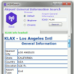
Airport General Information Search provides information such as,
General Info: Nearest City, Country, Elevation, Airport Type, Operation Type, Time Zone, Latitude, Longitude.
Airport Info: Heading, Length, Width, Altitude, Surface, ILS Frequency.
Communication Info: ATIS, APP, DEP, GND, TWR.
NavAid Info and Current Weather
AGIMSearch used data courtesy of smithplanet
| Filename: | AgimSearch_Airport_General_Information_Search.zip |
| License: | Freeware |
| Added: | 17th August 2017, 07:12:41 |
| Downloads: | 440 |
| Author: | Christopher Hall |
| Size: | 353.36 KB |
| Category: Civil Flight Simulators - Looking Glass Flight Unlimited 3 | |
| Flat and dry Heathrow Airport classification file |
|
File Description:
Robert Driscoll makes a wonderful Heathrow package.
My automatic classification generator expected the UK weather as very rainy and
so Heathrow is not only not flat enough for runways but also very wet.
This file and description will modify the classification and elevation of Heathrow airport to 78ft.
| Filename: | Flat_and_dry_Heathrow_Airport_classification_file.zip |
| License: | Freeware |
| Added: | 18th December 2002, 02:46:16 |
| Downloads: | 122 |
| Author: | André Meystre |
| Size: | 13.01 KB |
| Category: Flight Simulator 2002 - Scenery | |
| Quebec Terrain Mesh (1/5) |
|
File Description:
Re-uploaded file. New resolution (76m) terrain mesh of province of Quebec, Canada, covering longitude W58 to W80 and latitude N45 to N53. This resolution terrain mesh is based on SRTM-3 (90m) digital elevation models, resampled to LOD of 09 (76m). Five parts: qclod09a.zip, qclod09b.zip, qclod09c.zip, qclod09d.zip, qclod09e.zip.
| Filename: | Quebec_Terrain_Mesh_15.zip |
| License: | Freeware, limited distribution |
| Added: | 11th May 2010, 21:26:59 |
| Downloads: | 6,750 |
| Author: | Gilles Gauthier |
| Size: | 18.26 MB |
| Category: Flight Simulator 2004 - Scenery | |
| Cape Farvel, Greenland 76m SRTM Terrain Mesh |
|
File Description:
USGS SRTM 3 arc-second, resampled to LOD9 (76 meters). This is a terrain mesh scenery of Cape Farvel in southern Greenland. Coverage area: From West 45.6° to West 42.8° and North 59.6° to North 60.4°. (Cape Farvel is the only part of Greenland available as SRTM elevation model)
| Filename: | Cape_Farvel_Greenland_76m_SRTM_Terrain_Mesh.zip |
| License: | Freeware, limited distribution |
| Added: | 17th April 2004, 23:35:14 |
| Downloads: | 4,183 |
| Author: | Andreas Trawny |
| Size: | 1.55 MB |
| Category: Flight Simulator 2004 - Scenery | |
| Long Beach KLGB Version 4.0 (New Terminal Construction) |
|
Images related to this file:
File Description:

This is a transitional version of Long Beach Daugherty Field. A brand new terminal is currently under construction and due to open in 2013. This version of the scenery shows the terminal as built but not yet operational which reflects current operations as of November 2012. All parking stands have been moved from their original staggered locations to positions surrounding the new terminal complex. Airlines serving the airport have been updated, and other heavy modifications have also taken place. In addition, Signal Hill has been converted from the giant rock scenery object to a correct elevation change file. The hill now has autogen and proper positioning and elevation. A future update with the fully operational terminal will be forthcoming.
| Filename: | Long_Beach_KLGB_Version_40_New_Terminal_Constructi.zip |
| License: | Freeware |
| Added: | 28th October 2012, 12:58:03 |
| Downloads: | 2,628 |
| Author: | FRFStudio.net / William Morgan / Sheryar Ansari |
| Size: | 81.5 MB |
| Category: Flight Simulator X - Scenery | |
| Aurora Muni - Greater Kankakee |
|
File Description:
FSX Scenery - Aurora Municipal Airport serves Chicago/Aurora and Kane County and is owned by the City Of Aurora. The airport has more than one runway. The longest is a paved runway extending 6500 feet. The facility is at an elevation of 706 feet at a distance of about 38 miles from Chicago. Greater Kankakee Airport serves Kankakee and Kankakee County and is owned by Kankakee Valley Arpt Auth. The airport has more than one runway. The longest is a paved runway extending 5979 feet. The facility is at an elevation of 629 feet at a distance of about 3 miles from Kankakee. Created with Instant Scenery. By John B. Loney, Jr.
| Filename: | Aurora_Muni__Greater_Kankakee.zip |
| License: | Freeware, limited distribution |
| Added: | 2nd November 2009, 20:05:32 |
| Downloads: | 500 |
| Author: | John B. Loney, Jr. |
| Size: | 1.11 MB |
© 2001-2026 AVSIM Online
All Rights Reserved
Privacy Policy |