
Where Flight Simulation Enthusiasts Gather from Around the World!
AVSIM Library - Search Results

| Category: Flight Simulator X - Scenery | |
| GPS Enabled Oil Rig Platform |

|
File Description:
An FSX Oil rig placed at the correct real life coordinates about 100+ miles from Aberdeen and Peterhead. The landing pod has GPS facilities and a code of RIG1 Meaning you can start at the pod and/or fly to it by entering RIG1 into the GPS Direct To. A Cargo Ship sails from the tidal Aberdeen Harbour at 06:18 Local time and heads for Peterhead which is an hour away. It joins another Cargo ship there and the two set sail for the Piper alpha rig some 5 hours away. Sailings are twice a day and can be followed by boat plane. The rig landing pod is excellent for landing practice in a helicopter and especially with the built in GPS coordinates.
| Filename: | GPS_Enabled_Oil_Rig_Platform.zip |
| License: | Freeware |
| Added: | 20th November 2011, 00:43:58 |
| Downloads: | 575 |
| Author: | Steve Brooks |
| Size: | 6.26 KB |
| Category: Flight Simulator X - Original Aircraft | |
| Culver Cadet |
|
Images related to this file:
File Description:
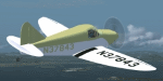
Here's the 1941 Culver Cadet for FSX. It's a major revision of the Culver Cadet I created back in 2004 for FS9. The improvements are too numerous to list, but I'll at least list a few: Much better flight model--validated by someone with 39 hours of actual Culver Cadet time (me!), better textures (four different Cadets included), full panel, and a detailed virtual cockpit. Pressing "A" cycles between several custom cameras (right seat, 3-point landing over-nose view, gear retraction view). Trackir 5 and/or Ezdoc recommended, to see everything. A 2d panel is also included. Sounds were obtained by recording an actual Cadet in-flight (engine, landing gear manual retraction, etc.). Four different paints included, for four different N numbers.
| Filename: | Culver_Cadet.zip |
| License: | Freeware |
| Added: | 13th May 2016, 08:11:35 |
| Downloads: | 585 |
| Author: | Dan Cowan |
| Size: | 19.26 MB |
| Category: Flight Simulator X - Scenery | |
| RAF Upper Heyford "1940s" - Oxfordshire, England |
|
File Description:
RAF Upper Heyford was a Royal Air Force station located 5 miles (8 km) north-west of Bicester near the village of Upper Heyford, Oxfordshire, England.
| Filename: | RAF_Upper_Heyford_1940s__Oxfordshire_England.zip |
| License: | Freeware |
| Added: | 21st May 2016, 20:33:23 |
| Downloads: | 157 |
| Author: | Terry Boissel |
| Size: | 1.27 MB |
| Category: Flight Simulator 2004 - Aircraft Repaints, Textures and Modifications | |
| TUI Airlines Belgium Boeing 767-341ER Winglets (OO-TUC) |
|
Images related to this file:
File Description:
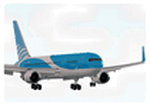
Jetairfly / TUI Airlines Belgium repaint for the LDS 767-300ER (Winglet model). This Belgian airline is part of the TUI group and uses two B767 's for its long haul operations to various destinations in the Caribbean (Montego Bay, Varadero, Punta Cana, Puerto Plata, Cancun & Costa Rica), Africa (Mombasa & Zanzibar), Colombo and Male.
Ex-Varig Boeing 767-341ER OO-TUC (cn 24844) joined the company in February 2005 and is configured with 257 seats in two classes. In April 2011 the OO-TUC has been retrofitted in Taipei with Aviation Partners Blended Winglets improving fuel economy by 5%.
Note: Textures only, Level-D Simulations 767-300ER add-on with winglet update required. Easy install with the Flight1 767 Repaint Manager.
| Filename: | TUI_Airlines_Belgium_Boeing_767341ER_Winglets_OOTU.zip |
| License: | Freeware, limited distribution |
| Added: | 19th May 2011, 21:16:12 |
| Downloads: | 1,280 |
| Author: | Sylvain Coolsaet - Level-D Simulations |
| Size: | 10.17 MB |
| Category: Microsoft Flight Simulator (2020) - Aircraft Repaints, Textures and Modifications | |
| Goodyear FG-1D Corsair VF-17 #29 Lt Kepford |
|
Images related to this file:
File Description:
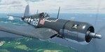
This folder contains a repaint for the FG-1D Corsair by Milviz, in the colors of F4U-1 BuNo 55995 of VF-17, the aircraft flown by Lt (jg) Ira C. Kepford, Bougainville, February 1944. Ira Cassius Kepford was born in Harvey, Illinois, on May 29, 1919, son of George Raymond and Emma McLaughlin Kepford. His family moved to Muskegon, Michigan, shortly after he was born. An all-around athlete at Muskegon High School from 1935-1937, he capped his prep career by being named an All-State back in his senior year. He enrolled at Northwestern University in 1938 to study for a dentistry career.
He enlisted in the U.S. Naval Reserve on August 18, 1941, and was honorably discharged on April 29, 1942, to accept appointment as Aviation Cadet, U.S.N.R. After flight training at the Naval Air Stations, Corpus Christi, Texas, and Miami, Florida, he became a Naval Aviator on November 5, 1942, and was commissioned Ensign, U.S.N.R., with date of rank October 16, 1942.
Detached from Naval Air Station, Miami, Florida, in December 1942, he served with Fighting Squadron 17 in the Pacific War Area until March 1944, where he became the U.S. Navy's leading ace, scoring a record 16 confirmed Japanese planes destroyed. That squadron won the Navy Unit Commendation and he was personally awarded the Navy Cross, a Gold Star in lieu of the second Navy Cross, the Silver Star Medal and the Distinguished Flying Cross.
From March until June he was attached to the Fleet Air, Alameda, Command, and the last six months of that year served with Fighting Squadron 84. In December 1944 he was transferred to the staff of Commander Fleet Air, West Coast, and remained in that assignment throughout the remaining period of hostilities. Repaint by Jan Kees Blom.
| Filename: | Goodyear_FG1D_Corsair_VF17_29_Lt_Kepford.zip |
| License: | Freeware |
| Added: | 4th April 2021, 15:38:23 |
| Downloads: | 63 |
| Author: | Jan Kees Blom |
| Size: | 41.83 MB |
| Category: Flight Simulator X - Original Aircraft | |
| Piaggio P-149D FS-X DX9 Edition |
|
File Description:
This is a re-edition of the Piaggio P-149D with FS-X retail\SP1\2\Accel DX9 compatibility (DX10 users need to convert textures). The original model for FS-2004 is MN_P149D.zip + P149_FIX.zip available on AVSIM & www.mariopilot.6x.to. P_149_fix.zip is already included in this FS-X update.
The Piaggio P-149 is a trainer-laison aircraft. It first flew in June 19th, 1953. I'ts a development of the P-148 model, with increased seat cpacity, tricycle retractable landing gear and a more powerful engine, featuring a three-bladed constant speed propeller. It was mainly used by German Luftwaffe as a training aircraft, that oredred 75 examples in 1955. Later in 1957 another 190 were manufactured under licence by Focke-Wulf. The D version is the one employed by Luftwaffe, while later some few P-149CH variants were used by Swissair as flying schools, and a few P-149U variants, with a new tailplane section to allow more rotation clearance on takeoff were used by Ouganda's Air Force. The P-149 Has a seating capacity of 4 with some examples being certified for 5 (both cases including pilot) and it's fully aerobatic, having G-limits set at +7\-4.5. After training activities ceased with Luftwaffe, several are still flying under civilian operators. This gMAX model features completely 3-D virtual cocpkit and cabin with advanced night lighting and custom special effects, plus a sound package recorded from the real thing. Simulates all systems onboard the real aircraft, coming with panel instructions. Flight Dynamics are built using only real data based on the 1% spreadsheet plus lots of manual tweaking for fine tuning. Read Notes before flying please... Enjoy!
Notes and documentation are the htm files in the P-149D aircraft folder.
| Filename: | Piaggio_P149D_FSX_DX9_Edition.zip |
| License: | Freeware |
| Added: | 11th October 2008, 13:10:16 |
| Downloads: | 7,242 |
| Author: | Mario Noriega |
| Size: | 16.61 MB |
| Category: Flight Simulator X - Gauges | |
| TCAS and Traffic Display Gauge V2.0 |
|
Images related to this file:
File Description:
This TCAS and Traffic Display Gauge Version 2.0 includes significant improvements from V1.0. It has been developed for the FSX Flight Simulator SP1/2 also. It should also work with Acceleration.The functionality for the TCAS part is based on general specs for commercial aircrafts. It does not provide in detail the function for a specific aircraft model. It is a generic gauge, and can be simple added to any aircraft as a standalone popup window.
In addition the gauge provides a AI traffic display in the ranges of 10,20, and 40 miles.Within this display mode, no TCAS rules are valid, which means all AI aircraft are displayed independent of any altitude or distance.
Improvements in V2.0 are: 1: Full TCAS and traffic display capability is provided even though your aircraft is on the ground. Only the trigger of the alarm/warn sound and the blinking lamp display willbe blocked. 2: An AI HDG pointer will be displayed. It shows in which direction the AI is moving. 3: A bearing pointer has been introduced. It allows the pilot to point to a specific AI.4: The AI additional text info display follows the structure of an ATC text.5:The AI additional text can be selected individually per AI with a mouse click.
6: Each AI display contains a ID index number (0 � 20).7: The design of the TCAS and Traffic Display Box has been updated.8: Increased the number of AIs displayed on the screen in display mode.
For installation and functional description look at the doc inside the ZIp.
CREDIT goes to :
Stefan Schneider for his support on special XML issues and TCAS functionality.
Bob Familton for his review of the documentation and testing for SP1 FSX.
Doug Dawson for his dsd-XML-sound interface in order to generate the sounds.
| Filename: | TCAS_and_Traffic_Display_Gauge_V20.zip |
| License: | Freeware |
| Added: | 25th October 2010, 13:37:36 |
| Downloads: | 3,762 |
| Author: | Dietmar Loleit |
| Size: | 981.32 KB |
| Category: Prepar3D V1-4 - Scenery | |
| KLVN - Airlake Airport - Lakeville, MN, USA |
|
File Description:
KLVN - Airlake Airport beta version .4 - by Jason Boche
This is an update of the default P3Dv4.5 KLVN airport. Aside from the original 12/30 runway, everything else at this airport has been completely ripped and replaced.
Enhancements include:
-Extended runway on each end to depict current configuration
-Accurate taxiways including Hamburg Ave. and buildings representing the current general aviation hangars
-Added navigational equipment on the field
-Added a few asphault and dirt service roads
-Added FBO and other buildings as close as I could match them
-Added some general aviation aircraft, civilians, vehicles at the FBO and hangars, and two fuel trucks
-Moved fuel station to where I believe it is currently according to Google maps with 100LL fuel trigger functional
-Moved the windsock to accurate location
-Moved the beacon to accurate location
-Moved GA parking spots
-Added trees around FBO and beacon
-Added utility poles
-Added a few square miles of Lakeville city, farm, and residential land class and autogen according to Google maps. This is probably the biggest improvement. It now looks like people live, work, and shop north/northwest of KLVN.
-Reworked the runway 12/30 blast pads to what I believe is the "proper" method. Instead of freehand polygon asphault, they are now actual runway extensions on both ends with yellow chevron markings
-Reworked the land class on the southwest end of the airport where I believe hangar expansion is intended. Prior to this, there was a sharp contrast between where the KLVN airport boundary ended and where generic farm landclass began which was right in the middle of the southwest taxiways and it looked bad. Now that whole region is grass and looks to be part of the airport parcel.
-Minor building adjustments west of the FBO to better match actual placement.
-Fixed a gap on the southeast end of Hamburg ave taxiway where it rounds the corner for the rwy 30 hold short line
-Randomized the directional facing of some of the cars parked at GA hangars
-Renumbered the parking spots 1-4 with #5 being the refueling spot
-Reversed the start direction of parking spots 1-3.
-Pulled the refueling parking "start" spot back because on start the engine cowling & prop were too far forward inside the fuel pump equipment
-Added an autogen exclusion to the rwy 12 short final due to trees popping up on short final path.
-KLVN tower viewpoint 25 meters above FBO.
-Removed the perimeter fence around the entire field
| Filename: | KLVN__Airlake_Airport__Lakeville_MN_USA.zip |
| License: | Freeware |
| Added: | 13th May 2020, 17:18:40 |
| Downloads: | 84 |
| Author: | Jason Boche |
| Size: | 14.81 KB |
| Category: Flight Simulator X - AFCAD Files | |
| KLVN - Airlake Airport - Lakeville, MN, USA |
|
File Description:
KLVN - Airlake Airport beta version .3 - by Jason Boche
This is an update of the default FSX KLVN airport. Aside from the original 12/30 runway, everything else at this airport has been completely ripped and replaced.
Enhancements include:
-Extended runway on each end to depict current configuration
-Accurate taxiways including Hamburg Ave. and buildings representing the current general aviation hangars
-Added navigational equipment on the field
-Added a few asphault and dirt service roads
-Added FBO and other buildings as close as I could match them
-Added some general aviation aircraft, civilians, vehicles at the FBO and hangars, and two fuel trucks
-Moved fuel station to where I believe it is currently according to Google maps with 100LL fuel trigger functional
-Moved the windsock to accurate location
-Moved the beacon to accurate location
-Moved GA parking spots
-Added trees around FBO and beacon
-Added utility poles
-Added a few square miles of Lakeville city, farm, and residential land class and autogen according to Google maps. This is probably the biggest improvement. It now looks like people live, work, and shop north/northwest of KLVN.
-Reworked the runway 12/30 blast pads to what I believe is the "proper" method. Instead of freehand polygon asphault, they are now actual runway extensions on both ends with yellow chevron markings
-Reworked the land class on the southwest end of the airport where I believe hangar expansion is intended. Prior to this, there was a sharp contrast between where the KLVN airport boundary ended and where generic farm landclass began which was right in the middle of the southwest taxiways and it looked bad. Now that whole region is grass and looks to be part of the airport parcel.
-Minor building adjustments west of the FBO to better match actual placement. Will only be shown on high scenery detail.
-Fixed a gap on the southeast end of Hamburg ave taxiway where it rounds the corner for the rwy 30 hold short line
-Randomized the directional facing of some of the cars parked at GA hangars
-Renumbered the parking spots 1-4 with #5 being the refueling spot
-Reversed the start direction of parking spots 1-3.
-Pulled the refueling parking "start" spot back because on start the engine cowling & prop were too far forward inside the fuel pump equipment
-Added an autogen exclusion to the rwy 12 short final due to trees popping up on short final path.
-KLVN tower viewpoint 25 meters above FBO.
-Removed the perimeter fence around the entire field
| Filename: | KLVN__Airlake_Airport__Lakeville_MN_USA.zip |
| License: | Freeware |
| Added: | 22nd November 2013, 23:26:10 |
| Downloads: | 226 |
| Author: | Jason Boche |
| Size: | 446.33 KB |
| Category: Flight Simulator 2004 - AFCAD Files | |
| Metro Oakland with Active Crosswind Runways |
|
File Description:
A high spec AFCAD2 for the FS2004 Metro Oakland Int'l Airport (KOAK) scenery by the Mach-1 Design Group. This afcad has been built using FAA Charts, various aerial photographs and information from the Airport Website. All taxiways are named and all aprons are reworked to be as real as possible according to photos. All gates are named and have airlines assigned to them. As per real life, only Southwest Airlines will use Terminal 2, all other airlines being allocated to Terminal 1. The Fedex and UPS aprons are represented and can accomodate many cargo aircraft. The final parking area is random GA parking to the north of the airport. Overflow parking is also available for rush hour periods. This airport features a tower view and also night and approach lighting. Finally, by using the crosswind runway technique, runways 9L/27R, 9R/27L and 11/29 can all be used simultaniously for take-off and landing. Runway 15/33 is closed as it is not used in real life. An extra taxiway "Zulu" has been added (not real life) to avoid AI conflicts when using runway 29 for Takeoffs and landings. Enjoy!! Requires that you install m1dg_oak2007.zip from this site.
| Filename: | Metro_Oakland_with_Active_Crosswind_Runways.zip |
| License: | Freeware |
| Added: | 1st June 2007, 17:44:02 |
| Downloads: | 1,461 |
| Author: | Lee Brompton |
| Size: | 203.67 KB |


© 2001-2026 AVSIM Online
All Rights Reserved
Privacy Policy |