
Where Flight Simulation Enthusiasts Gather from Around the World!
AVSIM Library - Search Results

| Category: Flight Simulator 2004 - AI Aircraft | |
| SKJ Antonov An-12 updated repaints in 32bit format |

|
File Description:
SKJ Antonov An-12 updated repaints for AI traffic. Thanks to Valeriy Storozshko (aka "ALFER") for adapting his paintkit for me. These updates are from my earlier paints when I first started painting the SKJ An-12. The newer repaints as follows are all OK: AeroVis fleet, Kabul Air fleet, Meridian Airlines fleet and the TAPO-Avia fleet. The earlier paints are wrong in as much as I disliked the paintkit's main EXIT door on the port side of the aircraft, it was way to square looking at the bottom and all these have been changed to a more rounded look as they are in reality. I also amended a few of those 3 little 'objects' at the top of the tail as most (apart from British Gulf) are either painted white or a pale grey. This is not really an important update, but to me it is as I have thing about windows and exits, a bit sad eh! Billy.
| Filename: | SKJ_Antonov_An12_updated_repaints_in_32bit_format.zip |
| License: | Freeware |
| Added: | 12th September 2008, 17:02:56 |
| Downloads: | 502 |
| Author: | Billy Rutherford |
| Size: | 9.93 MB |
| Category: Flight Simulator 2004 - Scenery | |
| Big Creek U60 public use airfield in Idaho USA |
|
File Description:
This airfield is in the mountains of Idaho, 30 miles south of Dixie A05, which was the first in the series to be posted. Big Creek is now regularly used for picnic fly-ins and overnight camping, or for just a day of fishing in the creek; the creek does not appear in FS9 as it is not exactly huge, and within the Ultimate Terrain USA settings I have in fact turned streams off as in some cases they cross the grass or (in conjunction with the roads) left insufficient runway space. The U60 runway is at 5,743 feet ASl, 3,550 feet long, aligned 01-19, and in good condition. At the southern end there is the new replica of the old original Big Creek Lodge which was built in 1935. This burned down in 2008, and is now being rebuilt by a group of pilots, pilots having formed a large part of the early clientel courtesy of the grass strip. It is shown here as still under construction. There are also Forest Service buildings on the west side of the runway. All of this is located in the Frank Church Wilderness area and the Payette National Forest. The AI is increased at the weekends, reflecting reality, and also revised to use Boise as one of the starting places. Dixie is also reissued here with a revised positioning to fit with the roads. I had concluded that the roads were wrong, while in fact the position of the airstrip was at fault.
| Filename: | Big_Creek_U60_public_use_airfield_in_Idaho_USA.zip |
| License: | Freeware, limited distribution |
| Added: | 25th May 2017, 17:53:58 |
| Downloads: | 132 |
| Author: | Roger Wensley |
| Size: | 11.06 MB |
| Category: Flight Simulator 2004 - Scenery | |
| Nanisivik CYSR and Arctic Bay CJX7 in Nunavut, Canada |
|
Images related to this file:
File Description:
Nanisivik is an airfield in the north of Baffin Island, 470 miles north of the Arctic circle. It was built to service a zinc and lead mine that was opened in 1976 as Canada's first Arctic mine, now closed and dismantled. The deep water Strathcona Sound has been ear-marked by the Canadian government for development as a naval base, so I have left the large ore storage shed and the jetty in place. The airfield is at 2,106 feet on the top of the Borden Peninsula hills with a lighted 6,400 feet of 150 feet wide gravel runway runway aligned 11/29. There is a terminal and other maintenance buildings, and First Air have a building there from when the mine generated a lot of traffic and jets were used. Arctic Bay is a village 11 miles west of Nanisivik airfield with a population of around 690 which also uses the Nanisivik airfield. There is another gravel strip much closer to the village that is called Arctic Bay CJX7, but this is smaller with only 1,500' of 50' wide gravel and has no facilities of any sort. The village is partly dependent on visiting sports hunters and other limited tourist visits. At almost 73 degrees north the average year will have only four or even three months where the average high is above freezing. The buildings on the field have been modelled specifically for this scenery, and as in real life there is only JetA available. The AI visiting aircraft are a Kenn Borek Twin Otter and a First Air 42-300. As Nanisivik is in the "Northern Domestic Airspace" the runway is signed in "true" bearings and not magnetic as magnetic compasses become unreliable close to the magnetic pole.
| Filename: | Nanisivik_CYSR_and_Arctic_Bay_CJX7_in_Nunavut_Cana.zip |
| License: | Freeware, limited distribution |
| Added: | 28th May 2011, 19:59:18 |
| Downloads: | 494 |
| Author: | Roger Wensley |
| Size: | 2.64 MB |
| Category: Flight Simulator 2004 - Aircraft Repaints, Textures and Modifications | |
| Saab Viggen in Swedish air force AJS "Martin 57" |
|
Images related to this file:
File Description:
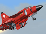
Re-uploaded ALPHASIM Saab Viggen in Swedish air force AJS "Martin 57" all red paint scheme.
| Filename: | Saab_Viggen_in_Swedish_air_force_AJS_Martin_57.zip |
| License: | Freeware |
| Added: | 13th May 2010, 21:08:02 |
| Downloads: | 290 |
| Author: | Repaints by pierre lheureux - Plane by Alphasim |
| Size: | 4.99 MB |
| Category: Flight Simulator 2004 - Scenery | |
| Arctic Runway Signs in the "Northern Domestic Airspace", Canada |
|
Images related to this file:
File Description:
These are scenery bgl's to replace those previously posted for Cape Dorset, Gjoa Haven, Igloolik, and Whale Cove. All of these airfields are within what is marked on the chart as "Northern Domestic Airspace" and their runway signage is not given as a magnetic bearing but as a true bearing. This is because at those latitudes, close to magnetic north, the magnetic field is more vertical than horizontal and magnetic readings become unreliable. Planes report their course as a true course, and fly at a height that reflects their true course instead of their magnetic course. The picture shows the runway sign for Qikiqtarjuaq CYVM (which used to be called Broughton Island) which I am working on right now, and I realised that my training was so far behind me that I had forgotten all of the above. The boundary line of the two air spaces is not a straight line; the furthest south it reaches is on the west coast of Hudson Bay just north of Churchill. To the east it passes through the southern end of Baffin Island, and to the west it is north of the coast at the Alaskan border, and there is an illustration included here.
| Filename: | Arctic_Runway_Signs_in_the_Northern_Domestic_Airsp.zip |
| License: | Freeware, limited distribution |
| Added: | 11th June 2011, 03:06:36 |
| Downloads: | 307 |
| Author: | Roger Wensley |
| Size: | 1.21 MB |
| Category: Flight Simulator 2004 - Scenery | |
| Hicks Farm Field CF12 near Ottawa in Ontario, Canada |
|
Images related to this file:
File Description:
Hicks Farm is in Ontario and around 8 miles west of Rideau Valley Airpark CPL3 (which did not appear in FS9, probably because it was then mainly used by gliders, but is a post of mine). CPL3 is 15 miles south of Ottawa Airport, tucked into a right angle bend of the Rideau River. Ultimate Terrain puts the river into place, and I am not sure of how or if either CPL3 or CF12 work without UT, maybe somebody can let me know. Fly west from CPL3 along the river and Hicks Farm will be on the south side. It has a (mainly) grass runway 34/16 with a section of asphalt and totals some 5,500 feet overall. Alan, the owner of Hicks Farm, is in his mid 80's and was told last year that his insurance company no longer felt comfortable with him flying his Lear off a farm strip. The result of his enforced retirement from flying his Lear is that the grass has been allowed to take over somewhat, though there is still sufficient space to land most single engine light aircraft.
| Filename: | Hicks_Farm_Field_CF12_near_Ottawa_in_Ontario_Canad.zip |
| License: | Freeware, limited distribution |
| Added: | 11th February 2010, 00:50:23 |
| Downloads: | 271 |
| Author: | Roger Wensley |
| Size: | 1.43 MB |
| Category: Flight Simulator 2004 - Scenery | |
| Kenmore Village Field CF08 near Ottawa in Ontario, Canada |
|
Images related to this file:
File Description:
Kenmore Village Field is in Ontario, at the northwest corner of the village of Kenmore. Kenmore is around 13 miles southeast of Ottawa airport and 3 miles east of Bank Farm Field. The village doesn't appear in FS as it is too small, but I have recreated it based on the roads that show in Ultimate Terrain. There is a grass runway 09/27 (actually 086/266) that is 3,100 feet long, and the grass is good, and with lights. The field is owned by a gentleman in his mid 70's who sold his plane five years ago and less than two years later discovered that he really didn't want to give up flying; he then went out and bought another slightly older and cheaper version of the one he sold. The house is in a direct line with the runway approach from the east; try to miss it. There is a large hangar and workshop behind the house and to the north of the runway center line, and a second older hangar on the same side a bit further along, both modeled specifically for this.
| Filename: | Kenmore_Village_Field_CF08_near_Ottawa_in_Ontario_.zip |
| License: | Freeware, limited distribution |
| Added: | 9th February 2010, 13:39:57 |
| Downloads: | 394 |
| Author: | Roger Wensley |
| Size: | 10.69 MB |
| Category: Flight Simulator 2004 - Scenery | |
| Killaloe CYXI near the Ottawa River in Ontario Canada |
|
File Description:
Killaloe is an old military airfield built for jet fighters in the 1950's,and now officially abandoned. It is 12 miles north of Madawaska Valley Airpark and just to the west of Round Lake, and there is no trouble spotting it as even from 20,000 feet (see the pic) it is very visible. This is mainly because it has a single 6,600 feet runway 29/11, which is likely to be useful if it all goes quiet and you need to land! So it is worth knowing about, even though the asphalt is not in a very good condition. It also continues to be used by the odd passing pilot who cannot resist adding another destination to his log book, though I have no personal knowledge of that. I understand local residents also use it for occasional drag racing, presumably unofficially.
| Filename: | Killaloe_CYXI_near_the_Ottawa_River_in_Ontario_Can.zip |
| License: | Freeware |
| Added: | 27th May 2008, 19:37:07 |
| Downloads: | 422 |
| Author: | Roger Wensley & Jim Turner |
| Size: | 593.04 KB |
| Category: Flight Simulator 2004 - Scenery | |
| Road 7 farm strip near Lake Ontario in Canada |
|
File Description:
Road 7 farm strip is some 15 miles east of Oshawa and 7 miles north of Lake Ontario, and as its name suggests it is next to county road 7. Just one of the hundreds that are waiting to be included into FS; if only there was more time in the day!
| Filename: | Road_7_farm_strip_near_Lake_Ontario_in_Canada.zip |
| License: | Freeware |
| Added: | 2nd August 2007, 00:31:13 |
| Downloads: | 433 |
| Author: | Roger Wensley and Jim Turner |
| Size: | 474.82 KB |
| Category: Flight Simulator 2004 - Aircraft Repaints, Textures and Modifications | |
| XB70 VALKYRIE in SST PAN AM fictionnal later livery |
|
File Description:
Fictionnal SST PAN AM later livery for Alphasim XB70 Valkyrie. These two Pan AM repaints ( early & later ) are a "one shot", just wanted to try such schemes on this beautiful bird.
In the 60's, North American did a study to develop the possibilities for an early American SST based on the XB-70 airframe, with a seating potential between 36 and 76 passengers.
Plane by Alphasim
Both textures sets work in FS9 and X.
| Filename: | XB70_VALKYRIE_in_SST_PAN_AM_fictionnal_later_liver.zip |
| License: | Freeware |
| Added: | 3rd August 2007, 22:20:16 |
| Downloads: | 686 |
| Author: | Repaint by pierre lheureux |
| Size: | 4.69 MB |
© 2001-2026 AVSIM Online
All Rights Reserved
Privacy Policy |